I unpack two prized possessions and tell the story of why they’ve been in boxes for three full years.
On Wednesday, I finally unpacked two of my most prized possessions: my antique lamps.
I have two of them, a Jefferson and a Handel (no, not a “Pairpoint Puff,” whatever that is). Their style is called “reverse painted” — scenes are hand-painted on the inside of a glass lampshade. When the lightbulbs under the shades are turned on, they light up the scene. They’re absolutely gorgeous, especially when lighted in an otherwise dark room. They date back to the 1920s, when they could be had for about $20-$30. They’re worth considerably more now.
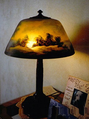
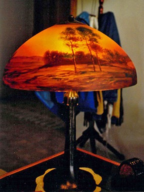
Photos of my two lamps in my old home. These must be old shots; the coatrack behind the Handel was replaced in the mid 2000s with a lodgepole coatrack my wasband gave me for Christmas.
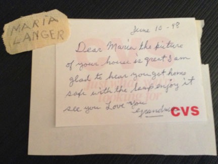
I took a picture of this note from my grandmother as a keepsake and it’s a good thing I did. It was evidence that I’d gotten the lamp prior to my marriage. The piece of tape with my name on it was stuck on the lamp for years; my grandmother wanted everyone to know that I should get the lamp when she died. In the end, she gave it to me four years before she died and I brought it from New Jersey to Arizona on the plane.
I got the Jefferson (the smaller blue one) from my grandmother before she died in 2002. I bought the Handel from my godfather, an antique dealer who specialized in lamps, a year or two later. The two lamps were accent pieces in the living room of my Arizona home.
Until I packed them.
When I got home from Washington in September 2012, my main concern was packing up my belongings in preparation to leave my home. You see, my husband at the time had found himself a new mommy/girlfriend online while I was gone, a desperate old whore 8 years older than him — yes, I know because everyone says it: bizarre — who would take my place in his life. (Or try to.) My now wasband had assured me that he wanted a quick settlement so we could save money on legal fees and get on with our lives. I figured I had just a few weeks to pack up my belongings and move out. The ones that meant the most to me would be packed first: the lamps and my Navajo rug.
My divorce was finally settled about a month ago — more than three years after my husband told me, on my birthday, that he wanted a divorce. It was a crazy, traumatic part of my life that I’m still in disbelief about. How can a good and reasonable man become so angry, vindictive, and delusional?
Back in 2013, I blogged about the contract I’d been offered for a book about the divorce. The book was delayed until the divorce was completely settled. For a while, I didn’t want to write it anyway — there was too much pain when I thought about how my wasband had thrown away the incredible life we were on the verge of having together. (As Adele says in this song, we could have had it all.) But as my new life got better and better and I saw how much I’d been able to achieve without him, I realized how much he’d held me back. I was truly so much better off without him. And while the pain of his betrayal will always be with me to some extent, I can now laugh with my friends over the things he and that old whore did to try to force me to settle, especially during the first year of the divorce process. And the appeal. And his attempt to get the appeals court to reconsider their decision. He’s crazy — that’s clear. And the story is incredible. It would make good reading.
A project for this winter? I think so. I think it’s time. And I have plenty of blog posts, email messages, and court documents to back up my tale. I think I might even get a chance to reveal the slutty 30-year-old lingerie photos the old whore sent him as part of her seduction routine. The playing cards I had made with those images are a real hit with friends. I wonder if he uses the two decks I left behind for him?
It’s a shame, really. As it turned out, my wasband wasn’t the least bit interested in a reasonable settlement. Not only did he want the paid-for house and everything in it, but he expected me to pay off the $30K balance on the home equity line of credit, give him another $50K in cash, and walk away with my business assets and retirement funds — most of which had been acquired before our six-year marriage. When I refused, and he refused my generous counteroffer, the lengthy (and costly) divorce battle began, made even lengthier by his repeated failure to comply with court orders and his delaying of the divorce court dates. So, as a result, I was stuck in the house until May 2013, with plenty of time to pack. I could have packed the lamps last and enjoyed them those last eight and a half months at home.
(And if you’re wondering how it all turned out, my wasband lost. And he lost his appeal, too. And he wound up paying me more than I’d asked for in my counteroffer back in December 2012. So much for saving money on legal fees. It cost him more than $200K than it could have to end the marriage, and he didn’t even get to keep the house. What an idiot. I swear he wasn’t this stupid — or greedy — when I married him. He must have picked up those traits from the old whore.)
Anyway, my lamps and rug were packed first. I packed them carefully, with plenty of packing paper and bubble wrap in a huge box. I nestled the two shades, one inside the other, with bubble wrap between them. The lamp bases went below them with their tops boxed up and cardboard separating their part of the big packing box from the glass shades. The rug went on top. I also packed the wooden “building” that goes with my Hummel nativity set — another heirloom item — along one side of the same box. (The figurines were also packed early on, but in a separate box better suited for their size.)
I stored my possessions in my old hangar until they could be moved to Washington. This shot was taken the day I moved out of my Wickenburg home: May 30, 2013.
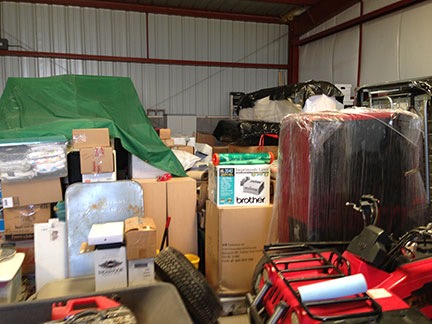
The box with the lamps went right from the house to the hangar I rented at Wickenburg Airport. They sat there, on a pallet in case of flooding, for a full year.
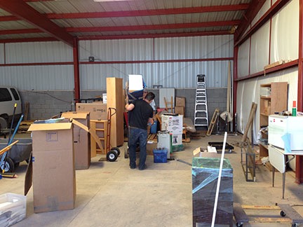
The movers to my Wickenburg hangar in September 2013.
In September (no, not June) of 2013, movers transported everything in the hangar from Wickenburg Airport to Wenatchee Airport, where I was renting another hangar. The boxes remained stacked up in the new hangar.
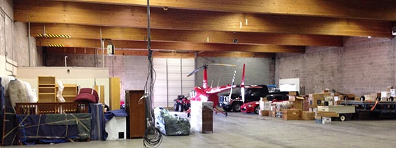
Most of my worldly possessions were stored in a hangar I rented in Wenatchee from September 2013 through June 2014. Boxes, vehicles, cargo trailer, and boat on right, furniture on left, helicopter with ATV in center for easy access to door.
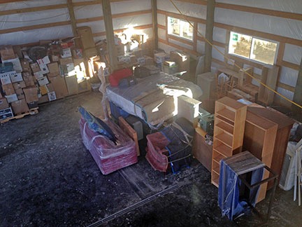
Here’s a shot from above after my friends helped me move everything into my building in June 2014. What a mess!
In June 2014, my friends helped me move everything from that hangar into my new building at my new home. The boxes were stacked haphazardly all over the back of the building. I moved them into the middle of the building and later, when I needed to get the RV in, moved them to the shop area. Sometime during the winter, I organized them by room so I could find things I needed to get at.
With all of these moves, the lamps’ box had been somewhat crushed by having other boxes stacked on top of it. I became a bit afraid to open it up. I was worried that the lamp shades — remember, they’re made of glass — had been damaged.
But this week, I decided that it was time. I had some friends coming from Auburn for a visit to see my new home. I’d already had custom end tables made and they’d been in my living room, looking bare, for about a month. There were only three things the living room needed to be finished: windowsills, a coffee table, and the lamps. The room would look more finished with the lamps. I wanted the room to look as finished as possible before my friends arrived so I had to get the lamps in place.
I unpacked the lamps on Wednesday. I still can’t believe how much paper was in that box. I certainly do know how to pack! And I’d worried for no reason: they were in perfect condition.
It took me four trips to bring them up from the garage: one each for the lamp bases and one each for the shades. I wasn’t taking any chances. I’d carry each one carefully.
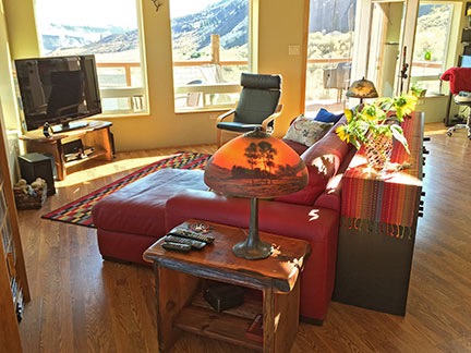
I put the Handel on the table closest to the kitchen and the Jefferson on the table closest to the deck door and my desk. (Another heirloom lamp, my monkey lamp, is already on my desk.)
They looked beautiful in my nearly finished room. I took a picture. On Friday, I shot a video of the room and shared it here on Saturday.
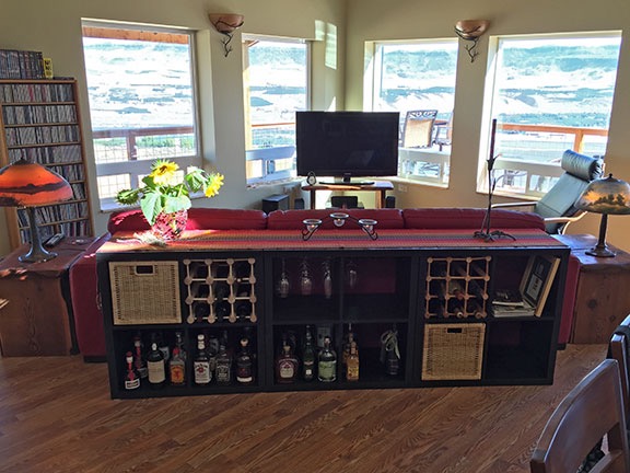
The lamps, one on either end of the nine-foot sofa, almost complete the living room.
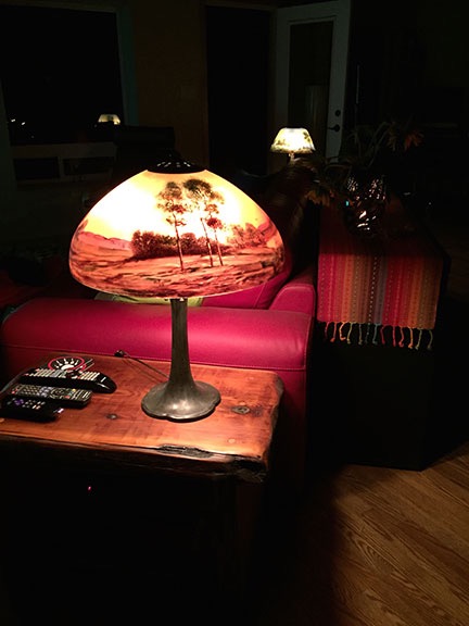
My lamps look best at night, when they provide the only illumination in a room.
Last night, I settled down for an hour or so on the sofa in front of the TV. I remembered the lamps. I killed all the lights in the room and turned on both lamps. They cast the perfect amount of light for an evening of relaxation in my new living room.
After three years in a box, I finally get to really enjoy them.
The ironic part about all this: I’ll get more use and enjoyment out of them here, in a room I use every day, than I got during the 10+ years they were in my Arizona living room, a room I only used when I had guests. And every time I light them up, I’ll think about the people I got them from: my grandmother and godfather, both now gone.
Thanks Grandma and Jackie! I’m taking good care of them.