My First Great Loop Adventure Comes to an Early End

I leave the boat after 35 days because of a crew member conflict.

I know I haven’t been blogging here for a long time, but that’s because I’ve been blogging on the My Great Loop Adventure website. For 35 days, I blogged every single day, falling behind more than once and managing to catch up. If you haven’t read any of those posts, I highly recommend that you do. Here’s a handy index in date order.

But I’m home now and back to work around my house. I’ve even managed to arrange to attend two art shows for selling my jewelry — shows that I would not have been able to do if I’d stayed on board the boat.

And that’s my point: I’m home about three weeks early. I had a huge problem with the other crew member and it got to the point where the trip just wasn’t fun anymore. I will expand on this in another blog post — I learned a lot about myself and dealing with other people. I will also blog a summary of the things I learned on the trip. And a summary of what was good and bad about the trip.

In other words, the 35 days I was on board Nano has given me plenty to write about. So stay tuned. I’m hoping to continue my one-post-a-day routine here in this blog — at least for a while.

Great Loop 2021: Tracking My Ride

I use the Nebo app to keep track of Nano’s progress as it makes its way to our rendezvous point in the NYC area.

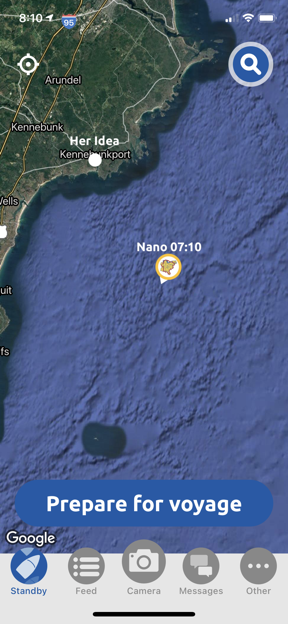
Nano, the boat I’ll soon be boarding for a nearly 2-month trip from New York to Chicago by way of the Hudson River, Erie Canal, and three Great Lakes, left the Portland area of Maine yesterday morning. I’ve been tracking it using the Nebo boating app since then.

Nano Off the Coast of Maine
I first picked up Nano in transit yesterday morning on my iPhone. It had left Portland an hour before and was off the coast of Kennebunkport.

Nebo is a popular system for boaters, especially those doing the Great Loop. I suspect it’s because the American Great Loop Cruisers’ Association (AGLCA), which I discussed in this blog post, offers discounts on the hardware you can install on your boat to automate tracking and trip logging. Indeed, most of the boats I’m seeing on the Nebo app are sporting the AGLCA logo as their profile pic — this is kind of cool because it makes it easy to see who may be on the same route as you. But while the automated features require hardware and a paid subscription to the service — which I assume offers additional features — anyone with a smart phone can set up the mobile app on a phone and enable manual tracking. It looks like that’s what First Mate Dianne did, since her account popped up on Nano as a crewmember yesterday, too.

Around midday, I checked their location again. They were at a marina near Gloucester, MA, at the end of a waterway that cuts the small Rockport peninsula from the mainland. They were done traveling for the day.

I sent Dianne a friend request and she accepted it. We exchanged a handful of messages yesterday. She sent a few photos — including a lobster tank in a supermarket and a fishing boat from a NatGeo channel show — and reported that the ocean was choppy but sunny and “delightful.” I was delighted just reading her comments.

(Capt Paul has not accepted my friend request. Not quite sure why. Maybe it’s because he knows he’ll soon get his fill of me. I’m going to try hard to behave.)

This morning, I checked again, keeping in mind that I’m three hours behind them — Pacific Daylight Time here and Eastern Daylight Time there. They were under way, off the coast of Boston. I started taking note of other Looper boats in the area. Curiosity had remained behind in Gloucester, but Done Tacking was ahead of them in Cape Cod Bay. I began wondering if I’d see these boats along the way once I boarded.

Nano off the Coast of Boston
This morning, Nano was off the coast of Boston.

Nano in Cape Cod Bay
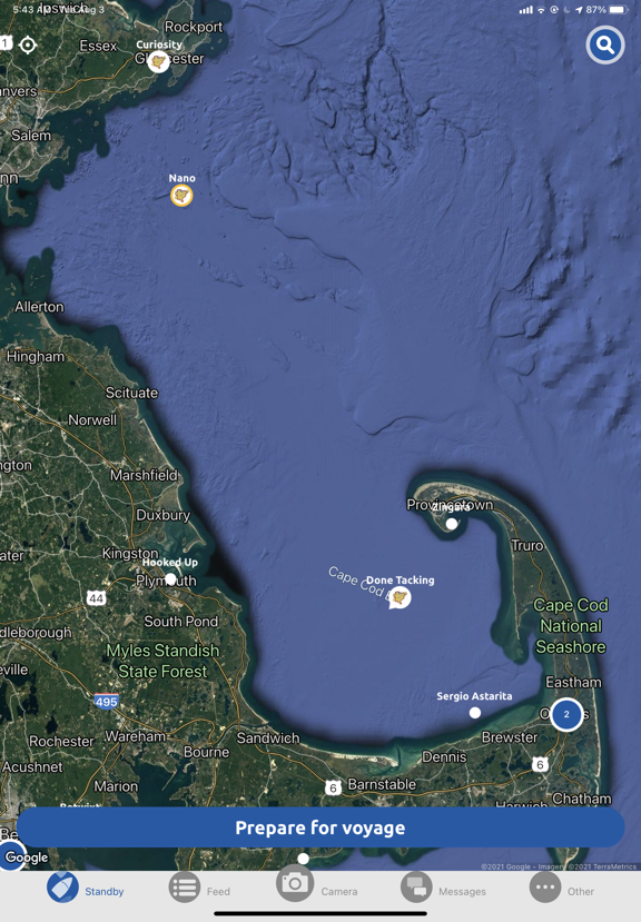
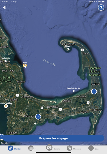
As I write this, Nano is close to shore inside Cape Cod Bay.

A little while ago, I checked again. Nano was now much closer to shore in Cape Cod Bay. (Done Tacking had already gone through the canal that separates Cape Cod from the mainland; you can see it near the bottom on the left.) I think Capt Paul’s plan had to been to spend the night at the mouth of the canal, but I don’t expect him to stick exactly to plan. My preliminary look at the weather shows rain in the area for the next few days; he might try to make some distance today in case he gets stuck at a marina waiting for weather to clear. I’m sure he’s considering the conditions and his options — much the way I consider weather and options when I’m doing a long cross-country flight in my helicopter.

Anyway, I’ll be tracking Nano as I continue to prep my home for my house sitter and pack up what I hope will fit into my luggage for the trip. I hope First Mate Dianne sends more photos. I believe she said she was going to blog the trip; I’ll try to get her blog’s URL so readers can see what she has to say about the trip as it happens.

Great Loop 2021: The Log Books

I create a custom log book to track my time on the water.

One of my goals as I head into my “golden years” is to get charter boat captain certification. The endorsement I’m interested in is commonly known as a “six pack,” meaning that I can take up to six passengers for hire on a boat. While I don’t expect to make charter boating my fourth (or fifth?) career, I’d like the ability to be able to cover my boating costs by occasionally taking paying passengers on day or overnight trips.

(And yes, I know I don’t have an appropriate boat yet. I’m working on that, too.)

About the Six Pack

The official name for the captain’s certification I’m looking for is National Operator of Uninspected Passenger Vessel (OUPV) of Less Than 100 GRT. The common abbreviation is OUPV 6-pack. According to the US Coast Guard, which oversees these certifications:

This officer endorsement is most appropriate for uninspected passenger vessels which by law are limited to six or less passengers for hire. These are usually smaller vessels and normally engage in charter fishing, whale watching, SCUBA diving, and tour cruises.

OUPV Near Coastal endorsements may be limited to 100 miles offshore, Inland or Great Lakes in accordance with 46 CFR 11.467 and the service provided. No OUPV endorsement is valid for International voyages.

There are a number of requirements to get this certification. Here’s a simplified list; you can download a more detailed list here:

  • U.S. Citizienship
  • 18 Years or age or older
  • Medical certificate
  • Drug testing compliance
  • Mariner fees paid
  • Sea service accumulated – 360 days
  • Sea service recency – 90 days in past 3 years
  • First aid course
  • CPR course
  • Exam or course completion certificate

Sea Service

The sea service requirement will be the toughest to meet and since it must be documented on the application, I’m motivated to keep track of it.

I’ve spoken to numerous people who have told me a variety of things about what constitutes “sea service.” One person I spoke to said that because he’d grown up boating with his family, all of those day trips could be logged as sea service. He said that even though he didn’t have a record of all of those days, he could make a reasonable estimate.

I’m in the same boat — no pun intended. My family had a boat that we’d often take on day trips on the Hudson River near New York City. In fact, a common outing would be a ride around Manhattan Island or down to the Statue of Liberty or up as far north as West Point. Later, when my family moved to Long Island, my family boated out in Long Island Sound. I have no idea how many outings we did as I was growing up, but I don’t think that 50 is an unreasonable estimate.

I also have boating experience as an adult on a variety of inland bodies of water including Lake George, Lake Powell, Lake Mead, Lake Pleasant, the Colorado River, the Columbia River, Lake Chelan, and Lake Roosevelt (in WA). Some of these trips involved overnight stays on the boat. Added up, I’m sure that would account for another 50 days.

And then there’s the Learn to Navigate the Inside Passage cruise that I went on back in 2019. This was the real deal: I was one of four people on a 65-foot, 90-year-old wooden boat that cruised at the breakneck speed of 6 knots up the Inside Passage between Bellingham, WA and Ketchikan, AK. For 12 days, I was a “crew member” while we learned about navigation and piloting from Captains Jeffrey and Christine. The following year, I joined them again for another 4 days on the water in the San Juan Islands. According to Captain Jeffrey, all this time could be logged.

David B at Garrison Bay
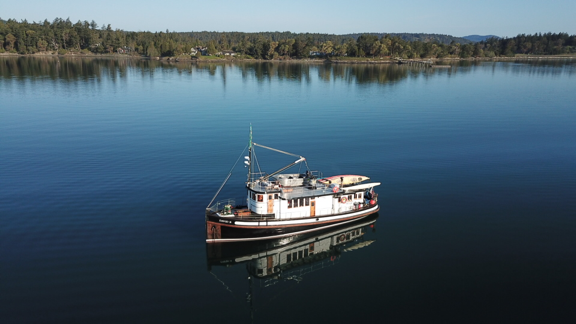
The David B at anchor in Garrison Bay.

It’s that time that was most valuable given that of the 360 days I needed on the water, 90 days of service had to be on Ocean, Near Coastal, or Great Lakes waters, depending on the kind of charter services I wanted to offer. Because I wanted to offer Near Coastal charter services in the San Juan Islands and possibly on portions of the Great Loop, I needed that Near Coastal time.

And my upcoming trip would be a huge addition to my sea service time. After all, I expected to be on the boat for about two months. That’s a lot of days of near coastal and Great Lakes time.

Finding a Book to Log Time

Of course, the best way to keep track of the time I could include in my sea service submission to the Coast Guard was to log it — much like I already log the time I fly to maintain a record of currency for my pilot certificate. With that in mind, I started looking for a “captain’s log” or “crew log” book.

And I found a lot of books that I just couldn’t see working for me.

The trouble is, most books were designed for either commercial boat captains or pleasure boaters:

  • The commercial captains’ logs had lots of form fields for entering daily boat and engine check information, weather, departure, destination, and miscellaneous paperwork information. This is the information you’d expect to be part of a legal record of every single day or trip on a commercial vessel. I simply didn’t need all of those form fields.
  • The pleasure boaters captains’ logs had less detailed forms but not much space for including a narrative of the trip. They didn’t seem concerned with logging time as much as logging where the boat went and who was on board.

I wanted something that combined features from both flavors of books, something where I could log each day of the journey and take notes for blog posts or other written accounts. And rather than enter detailed vessel information on each page — after all, I expected to be on the same handful of boats as I built my time — I wanted vessel details listed separately. I also wanted pages that summarized the days logged by month and by vessel.

So I designed my own book.

My Captain/Crew Log Book

Creating my own book pages wasn’t a big deal once I knew what I wanted on each page. After all, from about 1995 to 2012, I did layout of about half the books I wrote using a variety (over the years) of desktop publishing software: QuarkExpress, PageMaker, FrameMaker, and InDesign.

I’ve had a love/hate relationship with desktop publishing software for a while now. In my later days of writing books, I used Adobe InDesign to do page layout and then to generate PDFs and ebook format files for publishing. But when InDesign went from a pay once software package to a subscription software package, I simply stopped using it. I couldn’t see paying monthly for a software package that I only used a few times a year.

Just before I began tackling this design project, however, I got my hands on Affinity Publisher, a desktop publishing package that was inexpensive and didn’t require a subscription to use. I decided to try my hand at using it while doing this project.

It went remarkably well. Affinity Publisher was similar enough to InDesign that the learning curve was relatively easy for me. When I got stumped, I used its online help feature to figure out how to do what I needed to do. Little by little, I built up the master page styles that would make up my book. Then it was just a matter of adding pages.

Some of the design choices I made include:

  • 8.5 x 5.5 page size. This is half a standard “letter size” sheet of paper. It makes the book relatively small.
  • Spiral binding. This makes it easy to lay the book open and, if necessary, to remove pages.
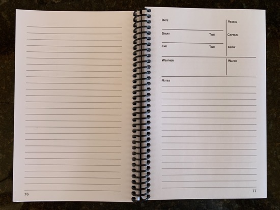
  • Double sided log pages. The recto (right side) page has the form to detail the entry and it’s followed by half a page of lines for notes. The back of each page has more room for notes. Again, I wanted to be able to include a lot of notes for each logged day. I chose this format instead of spreads — where the start of each entry would be on the verso (left) side and the rest on the recto side — because I wanted to be able to remove pages if necessary. I’m still not 100% sure about this decision; I think it would work either way.

    Log Book Pages
    A log page spread. The entry starts on the recto page and ends on the following verso page.

  • Simple summaries at the beginning of the book. I could add entries here as time went on.
  • Vessel Info
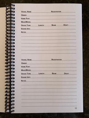
    There are three double-sided Vessel Info pages that I can use to enter details about up to 12 boats.

    Vessel details at the beginning of the book. Each vessel could be listed on a half-page form at the beginning of the book. This keeps those details off the log pages. I write the vessel name in the log page and then can cross reference it to details in the vessel list.

Log Book Cover
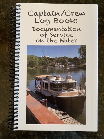
Here’s the book’s cover, with a nice photo of Nano on it.

I got a high-res photo of the boat I’ll be on this summer, Nano, to put on the cover.

I used a service called Printivity to print my books. I submitted a properly prepared PDF, made my payment, and waited. At my request, a representative got back to me to answer some questions and, with the information she provided, I fine-tuned some options.

Although the books were affordable to print, shipping was costly. To get the most bang for my buck, I ordered four copies. I figured I’d give the extras away to my fellow crew members, if they’re interested.

The books arrived two weeks after I submitted the PDF and paid for them. They looked pretty darn good for a first effort. I’m looking forward to making entries in mine during the trip.

Great Loop 2021: Plotting the Course

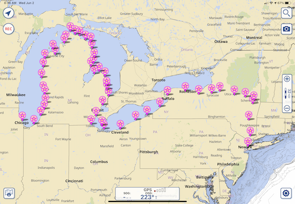
I put the planned overnight stops into a navigation app to get a general idea of the route.

When Capt Paul was interviewing crew members for his trip from Maine to Chicago by way of the Hudson River, Erie Canal, and Great Lakes, he sent each of us a PDF of a spreadsheet that he had created that listed the days of the journey, the expected stopping point each night, the distance between points, and expected dates of arrival and departure. I had taken a look at the list and had even tried once or twice to plot the route, but it wasn’t until today that I sat down and entered each planned stop as a waypoint in a navigation app.

What changed? Well, I tried a different, more user-friendly marine navigation app, Aqua Map.

A Tale of Two Marine Navigation Apps

TZ iBoat
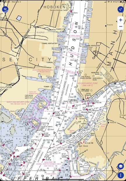
Here’s New York Harbor as it appears in TZ iBoat. This is a raster (“r” = “real” is my way to remember it) chart. TZ iBoat will automatically switch to the view magnification that’s appropriate for the scale I’ve zoomed to.

Years ago, when I did the Learn to Navigate the Inside Passage cruise with Northwest Navigation, I looked for (and found) an app that would run on my iPad and display our position on real nautical charts. That app was TZ iBoat. I chose it because it (1) enabled me to download charts so I didn’t need an active Internet connection and (2) it supported raster charts, which are basically scanned and location encoded versions of traditional printed NOAA (or, in the case of that trip, Canadian) charts. I wanted raster charts because I wanted something that looked like the paper I’d need to consult when actually cruising. Call me old fashioned, but I’m the same way with aeronatuical navigation apps like Foreflight — I always consult the sectional chart version because that’s what I’m used to.

TZ iBoat wasn’t terribly expensive. The app was free but I’d need an annual subscription to get the charts. That’s showing as $19.99 today on the App store but I’m pretty sure I paid more. I’m thinking $35. Still a lot cheaper and easier than buying printed charts.

When this Great Loop trip came up, I renewed my subscription for USA coverage. I already knew the software pretty well, so it would be easy enough to use it on this trip.

Aqua Map
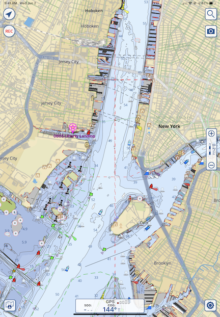
Aqua Map’s view of New York Harbor at roughly the same magnification. Because this is a vector chart, the more I zoom in, the more details are displayed.

But then Capt Paul told me about Aqua Map. I downloaded it to give it a try. I immediately realized that it had some major benefits over TZ Boat: it could display data overlays from other sources, including Waterway Guide. So in addition to charts, it would give me data about marinas, anchorages, locks, and other facilities that either aren’t included on charts or have limited information on charts. The app was free; a subscription for the US and Canada, including charted lakes, rivers, and canals, was $14.99. I subscribed and linked it with my Waterway Guide subscription. (This, I’m pretty sure, makes it unnecessary for me to subscribe to the digital version of Waterway Guide in that app.)

The only drawback to Aqua Map: it uses vector charts instead of the raster charts I prefer.

But is that really a drawback? Maybe I just need to face it: vector charts, with their customizable display layers, are probably the future of navigation, whether it’s marine or aviation. Maybe it’s time for me to move into the 21st century after all.

Of course, I’ll have both with me on the trip. My new iPad has plenty of room for both of them and the downloaded charts I’ll need along the way.

Plotting the Route

There were two ways I could plot out the planned route:

  • Create waypoints for each stop along the way.
  • Create a route with connected waypoints for each stop along the way.

I decided to just create the waypoints. I wasn’t going to steer the boat and, even if I did need a route laid out between obstacles, I could always create it on the day of the trip. All this data could easily be stored in the app. For now, all I really wanted to know was the general planned route and I figured that would show up well enough once the waypoints had been entered.

I did that this morning while I had my coffee and breakfast. It took quite a while. There were 51 overnight stops on the plan — some planned for more than one night — and they had to be located and created individually. I quickly learned to use Aqua Map’s search feature to find one point after another and create the waypoint. I named them with the 4-digit planned date (which I already knew was no longer accurate because we planned a later departure from New York) and the stop name. So the first waypoint I created was 0805 Liberty Landing for August 5 Liberty Landing Marina.

I only had one problem and that was when putting in the waypoints for Liverpool and Onodaga (in New York on the Canal). It seemed to me that they were the same place; I’m still waiting for Capt Paul to get back to me on my query.

Once I zoomed out, the route became clear. While it looks like we’re boating across dry land as we cross New York, it also clearly shows which side of each of the Great Lakes we’ll be cruising along and the fact that points seem closer together on the Lakes than in the Canal.

IMG 0081
Here’s the big picture look at our original planned route.

Of course, Capt Paul and his crew will be doing more than this. He’s starting in Portland, ME and finishing up in Stuart, FL. What I did here represents a fraction of his cruise. But since I’m not going to be on board for anything beyond this, I didn’t bother plotting it.

Keep in mind that this is the general plan — a starting point for knowing where we’re going and how long it will take. I seriously doubt we’ll follow this to the letter. Capt Paul is already making changes to overnight stops along the way so we can enjoy a dinner at the Culinary Institute of America in Hyde Park after leaving New York City. I’ll be making an updated version of the route as we travel.

I’m also starting to consider turning the breadcrumbs subscription back on for my ancient Spot Messenger — if I can find it — so friends and family members can track me in real time. It might be worth it if I can get a pay-as-you-go monthly subscription and buy those lithium batteries it sucks down in bulk.

My Thoughts on the American Great Loop Cruisers’ Association

Some thoughts after about a month of membership.

I’m writing this blog post mostly because I said I would elsewhere. I’ll try to keep it brief.

Great Loop Logo
The AGLCA logo and a map of the route(s) on the home page of the organization’s website.

If you’ve been following my blog, you know I’m interested in completing the Great Loop. In an effort to learn all I can about it in preparation for the year-long journey, I began looking for resources online. The American Great Loop Cruisers’ Association was one of the resources I found.

At first, there were just two organizational resources that interested me: videos about the Loop and the Rendezvous.

The Videos

There are a lot of videos and most were tagged $25 each, which really put me off. I honestly couldn’t imagine them charging members a fee to watch existing content, many of which appeared to be narrated PowerPoint slide shows. I assumed that the videos were free to members and it was one of the reasons I joined up.

I was wrong. The $25 per video fee was on top of annual membership. Yes, there are a handful of videos that I could watch for free and my registration to the Rendezvous (see below) included credits I could apply to two (I think) more. So simply joining the organization wasn’t going to get me much closer to seeing educational video content unless I was willing to dish out more money.

Video for a Fee
Is it worth paying another $25 to watch this webinar? I don’t know.

Understand this: I don’t mind paying for content I can learn from. But the price has to be related to the actual quality of the content. $25 to watch a 45-minute narrated PowerPoint slide show seems excessive to me. I understand that videos cost money to produce and host, but I also believe that they’d get a lot more views and likely take in a lot more money if they made the price more reasonable — maybe $5 or $10 each. At this point, I’m not terribly interested in spending $25 on a video that might or might not provide information I can benefit from.

The Rendezvous

The Rendezvous is an event held twice (or maybe three times?) a year. Normally, it’s held live at a location along the loop. For example, they’re planning an autumn rendezvous in Alabama and a new (I think) winter rendezvous in Florida. It’s designed for folks getting ready to start the journey, but it also seems like a good way to just pack in a lot of information.

Because of COVID, this spring’s rendezvous was held as webinars. That was actually good for me because it meant that I could attend without having to travel.

The Rendezvous includes social and educational activities: “docktail” parties, seminars, a vendor expo, etc. It seems like a good opportunity to network with other cruisers, learn about new products, get route briefings, and build a base of information about the trip.

I signed up for the spring rendezvous. It was conducted over a three week period with sessions on Tuesdays and Thursdays. There was a midday (EDT) “Lunch and Learn” which was basically a vendor talking about his/her products. I learned about Waterway Guide, which I wound up subscribing to. In the evening (afternoon for me), there were route briefings, each segment focusing on a different part of the loop. The presenters were actual loopers who narrated their slide decks either in a recording or live. Some were excellent — the couple who talked about the Chesapeake Bay and the guy who covered the Erie Canal were very good. Others were good but could have been better. (These were not professional speakers.) At the end of each presentation, they answered questions we’d ask either live or via text.

There were also two “small group” sessions, which were handled like Zoom meetings. Those were nice because you got a chance to chat with a small handful of other loopers. In person social events would (of course) be better, but this was a good substitute.

There was an online Expo and Q&A sessions concentrating on specific topics. Unfortunately, they were held at the same time. I chose the Q&A session for the Erie Canal so I missed other sessions I might of benefited from, as well as the Expo.

I did learn a lot and the good presentations really fed my desire to do the trip. Unfortunately, I missed or arrived late for some presentations. I didn’t get the links I needed a few times and had to scramble to contact the office to get them. Other times, I simply couldn’t take time off to attend — after all, this was in the morning or afternoon for me because of the time difference. What’s good is that I can apparently watch (or rewatch) any of the presentations as videos without having to pay for them again.

Overall, I think it was worth the cost to attend: $165 (on top of the $89 AGLCA membership fee; you must be a member to attend).

Other Benefits

Of course, the annual membership fee includes other benefits that are listed on the website. The funny thing about membership benefits is that they’re really not worth much if you don’t need/want/use them.

But one of the benefits is discounts at certain sponsor locations. Waterway Guide is one of those sponsors and I used my AGLCA discount to buy my Waterway Guide membership, thus getting two very detailed guides about parts of the loop. I also used the discount to buy another book about the loop. If I use enough discounts, it should (theoretically) cover the cost of membership.

Another benefit is access to a member forum where members ask and answer questions. This is a typical forum like you’d find for any group, but these folks are mature adults who don’t troll and act like assholes. So if you have a question — no matter how basic — you can be assured that someone will give you a good answer for it without humiliating you. They also share information about problems along the route — for example, lock closures or fuel unavailability. They even share opinions about marina service and anchorages. There’s lots there and it can be found on the website or delivered to you via daily emails.

Full access to classified ads is also a benefit, and it’s one I took advantage of to get on the crew of a boat doing part of the loop starting later this summer.

There are Looper Lifestyle seminars held a few times a year at various locations along the loop. I suspect that these have been put on hold during COVID, but they do appear on the calendar for the future, so they might actually happen. Keeping in mind that a lot of folks live full-time on their boats, this is probably pretty informative for them.

Worth It?

I’m pretty leery of “associations.” I’ve been conned into joining more than a few that weren’t what I expected them to be.

Helicopter Association International (HAI) is a perfect example. This organization seems to cater to big helicopter operators while pretty much ignoring the needs of the little guy. I honestly believe that it was started by a bunch of guys who saw a way to make a living traveling around the country to host events while occasionally acting as spokespeople for the helicopter community. I got sucked into joining twice and let my membership lapse with a very bad taste in my mouth both times.

I’ve also had an unsatisfactory experience with Whirly Girls, an organization of female helicopter pilots. I blogged about my experience here, so I won’t cover it again.

So while I like being part of groups of people who share similar backgrounds or interests, I’m not the kind of person who will just pay up to be a member. I need the organization to satisfy my needs.

In this case, my need is for information. The AGLCA does satisfy my need, but there’s a lot of pay-as-you-go along the way. I’m starting out, my knowledge base was nearly blank. They’re helping me fill it in and I believe the forums will be very useful for getting questions answered.

The fee is $89/year with discounts for longer terms or a lifetime membership. Is it worth it? I think it might be, at least right now. If those videos were free to members, it would definitely be worth it.

Footnote:

Last night, I watched one of the webinars that normally costs $25 but was free for AGLCA members. To watch it, I had to follow a link to get a promo code, then log into Vimeo, click to Rent the video, and enter the promo code. It took about 10 minutes for the video to appear in the Vimeo app on my television, but when it did, was able to watch it on the big screen.

It was an Aqua Map app demonstration by the developers. Although the video quality started out pretty bad (on a 4K TV), either I got used to it or it improved because it didn’t seem so bothersome after the initial shock. The developers had recorded and edited a tutorial style video that showed finger tapping on a smaller screen and results on a bigger screen. That was pretty effective, despite the strong Italian accents of the presenters. They gave a good tour of the app, but spent (in my opinion) too much time on the “Master” features that I don’t think will appeal to average users. I still don’t know how they got river mileage to display; they showed the feature but not how to enable it. When the tutorial video was over, they answered questions that had been posted live during the webinar. This didn’t go as smoothly as it could have, but they were definitely trying hard.

On a scale of 1 to 5, I’d give the webinar a 3. That score reflects the length of time they spent on Master features and the difficulty they had answering questions quickly and effectively. It wasn’t a waste of my time, but I sure wish it hadn’t been 90 minutes long.

Was it worth $25? I say no. I hope the other ones I get a chance to view are better.