Joy-Flying on a Saturday Afternoon

It’s days like this when I feel very privileged.

I spent most of yesterday morning at my desk, editing videos I recorded the previous afternoon. It was boring, tedious work, made even more unpleasant by a stupid little nagging headache I’d had for more than 24 hours. In general, I was feeling under the weather and I couldn’t understand why. It was a nice day and I had most of the windows in my RV open for fresh air. Even Alex the Bird was behaving.

I worked on a book for a while, then decided I needed a break. I’d head into town and pick up a few groceries, along with an ice cream sundae. That would make me feel better.

The supermarket parking lot was unusually crowded. That’s when I realized it was Memorial Day Weekend. (One of the oddities of being a freelancer is being completely oblivious to things like weekends and holidays.) The parking lot was crowded and so was the store. I realized that many of the people shopping for their holiday weekend groceries were young people who were likely camped out at Crescent Bar.


View Quincy, WA in a larger map

Crescent Bar is a mostly manmade island extending down along the Columbia River just before it enters a gorge. There’s a campground, a few trailer parks, some condos, a golf course, boat ramps, and a cherry orchard (belonging to one of my clients) down there. On weekends, it’s a popular destination for water lovers.

Seeing these people filling their shopping carts with chips and salsa and hamburger buns gave me a brainstorm. Why not take a little flight down to the river and around Quincy Lakes? And maybe even past the Gorge Amphitheater? Hell, I was a helicopter pilot. I had a helicopter parked at an ag strip within sight of my RV. Why the hell wasn’t I flying it?

(For the record, one reason I wasn’t flying it is because it costs a fortune to fly and I’m not made of money — although too many people think I am. Still, occasionally I do need to treat myself to a flight that doesn’t have a “mission” attached to it. Today would be that day.)

So I drove back the RV, stowed my groceries, and hopped back in the truck. A while later, I was standing on the truck’s bed, gently pulling off the blade covers. After a quick preflight, I climbed on board, and started the engine. I did some paperwork while everything was warming up. Then I donned my headset, waved to the ag pilots who were hanging out by the office door, and took off.

Where I live in Quincy is a good 700 feet higher in elevation than the Columbia River. The river flows in a gorge carved out by massive ice age flooding. Quincy sits on a sort of shelf full of irrigated farmland; there’s another, higher shelf to the north covered with wheat fields. The area is fascinating from a geologic perspective. You can really appreciate it when you fly over and through it in a helicopter — which I’d done numerous times in the past two years. I like flying along the towering basalt cliffs and over the various formations formed by those floods.

I hooked up with the road and descended with it through a valley that dropped in steps down to the river. I was cruising at 110 knots. I slipped over the final step and descended down to about 200 feet over the river. There were lots of boats and jet skis speeding around. The campground was full. I circled a small island where some people were camped out, then sped off downriver.

Crescent Bar

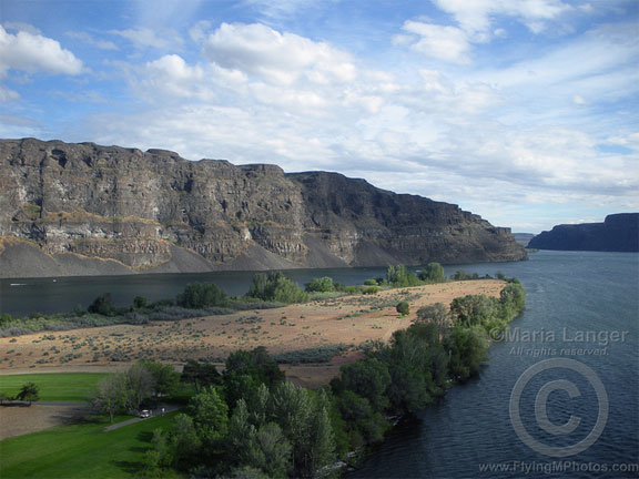
I snapped this photo of the south end of Crescent Bar as I left the area. Quincy’s farmland is spread out on the shelf above the cliffs on the left side of this photo. (View a larger version in my photo gallery.)

Farther downriver, I swung to the east and climbed over the edge of the gorge. I sped over Dusty Lake, where Mike and I had gone hiking with Mike’s cousin Rick and his friend last year. A few fishermen stood on the southwest side of the lake and looked up at me as I zipped past. Then, dodging wires, I climbed back up to Quincy’s level and headed southwest. The Gorge Amphitheater was packed with cars, tents, and people. A show was going on. I kept my distance as I swooped past, then dropped behind the stage and headed back upriver over a rock shelf covered with ancient potholes. Then I was abeam Quincy Lakes again and chose another of the two flood-carved canyons to fly up.

Quincy Lakes

This is Ancient Lake, fed by a waterfall that, in turn, is fed by runoff irrigation water. Quincy’s farmland is spread out on the shelf beyond these cliffs. (View a larger version in my photo gallery.)

I zipped back over the farmland south of Quincy. I noticed that my GPS wasn’t working quite right — a restart was required to fix it — but I knew my way back to the ag strip without it. The ag pilots were just leaving when I touched down. I’d been out for just a half hour. My mood was considerably brightened and my headache was just about gone.

Because of a gusty little wind coming out of the west, flying wasn’t smooth enough to make the flight perfect, but it was good to get out and about. What I really like is flying on those windless mornings or afternoons, when the river is glassy, reflecting the cliffs and clouds. When it’s like that, I can fly low over the water and around the canyons in effortless control of the aircraft. That’s magic.

As you can see, I got two reasonably good photos of the area while I was flying. I used a Nikon Coolpix camera for these shots. Although I really don’t like the camera in general — it doesn’t seem to work as well as the Canon Powershots I had before it — it’s easy enough to use with one hand (my left) as I fly. I can’t really frame a shot — I literally point and shoot and hope for the best. On these shots, the light was low and soft enough to prevent glare through the cockpit bubble. I lucked out.

Light Matters

Two shots prove it.

We spent Monday night camped out along the east shore of the Snake River in Hell’s Gate State Park, just south of Lewiston, ID. The river is held back by a dam downstream to form a long, meandering lake that has plenty of boat traffic, including the “jet boats” that take people upriver through Hell’s Canyon. All that traffic makes for rough water, but I reasoned that early in the morning, around dawn, the water could be pretty calm. With first light on the gold-colored hills across the river from our campsite, I might be able to photograph some interesting reflections without a lot of effort.

While the idea of waking before dawn to take a few photos might seem like a chore to some folks, it isn’t usually a big deal to me. I’m usually awake by 6 AM anyway, and that was certainly the case on Tuesday morning. So I threw on some clothes, grabbed my camera and tripod, and went out along the path behind the camper to see what I could shoot.

What I ended up with was a great example of how the quality and color of light can change a photo.

Before the Sun

This first shot reveals an interesting scene in gray light. Photo details: 1/50 sec, f4.8, ISO 200, 35mm

I set up and framed my shot. The reflections were as good as I’d hoped and the shots achieved the almost mirror-like look of land reflected on water. But the light wasn’t quite right for the first bunch of shots. Even after the sun rose, it failed to cast its rays on the scene before me. For a while, it was the high hills behind me, to the east, that kept the sunlight off my scene. Then it was a cloud. The light was gray and colorless.

After the Sun

This shot was taken a minute later, when the cloud had moved away, revealing the sun. Photo details: 1/80 sec, f4.8, ISO 200, 35mm

Then, suddenly, the cloud slipped away and the low sun shone directly on the scene before me. It lit up with a golden glow and I snapped another photo. This shot was taken exactly one minute after the previous one. Rather than slowly creep down the scene to illuminate it, the sun shined full on the scene, all at once.

It wasn’t until I reviewed these two shots in quick succession in my camera that I noticed the dramatic difference you see here. These images were not manipulated in any way in an image editing program other than to downsize them for the Web. I think they speak for themselves as they are.

I’ve read a lot about photography, especially in the past year or so. One of the things I read recently was a “tip” by a photographer who basically said not to bother shooting in bad light. These two photos do a pretty good job of explaining why light is so important. And while I won’t tell anyone not to shoot in bad light, I hope these photos help them understand how light can make a difference in their photography.

Leaving Red Creek

Another helicopter video.

I’m finding a bunch of gems on my hard disk. Figured I’d share them online.

We’d stopped at the Red Creek landing strip on our way down the Verde River when we saw another helicopter parked there. We were working on a video project and wanted to interview the pilots. They must have been down by the river because they weren’t anywhere near the helicopter. So after screwing around on the ground for a while, we took off back down the strip and turned downriver to complete our flight. This video was taken with a nose-mounted POV.1 camera.

Skycrane

In Wickenburg.

Sikorsky S-64 SkycraneIn May 2006, a Sikorsky S-64 Skycrane stopped at Wickenburg for fuel on its way to Tucson. Three of Wickenburg’s four resident helicopter owners — including me — were on hand, attracted to the helicopter like bees to honey.

The helicopter, painted bright orange and carrying a crew of three and firefighting equipment, landed at Wickenburg Municipal Airport just after 10 AM on a Sunday morning. It had flown directly to Wickenburg from its last refueling stop at Bullhead City on the Colorado River near Laughlin, NV.

The crew took some time to chat with onlookers and provide information about the rare helicopter. At the time, Tanker 733, as this helicopter was designated for firefighting, was one of only three Skycranes operating in the United States. All other Skycranes were abroad on other missions.

According to the crew, the Skycrane, which weighs over 20,000 pounds, can lift over 25,000 pounds. Its firefighting equipment enables it to suck several thousand gallons of water from a water source at least 18 inches deep in less than a minute. The water is then mixed on board with fire retardant chemicals and sprayed with precision over fires. The helicopter burns approximately 500 gallons of fuel per hour — and you thought your SUV was a gas hog!

Could it Be? Monsoon Season?

Heat’s not enough. I want humidity and rain, too.

This morning, when I woke at 5:30 AM to the whistles of my parrot, I was surprised to see that Mike hadn’t opened the French door between our bedroom and the upstairs patio. He always opens it during the night this time of year. That’s the only time it’s cool.

But when I opened it, I realized why: it wasn’t cool. For the first time this season, the outside temperature remained in the 80s overnight. And that’s the first sign of what everyone in Arizona is waiting for this time of year: monsoon season.

A Monsoon? In the Desert?

Sure. I can’t make this stuff up.

Monsoon season in Arizona is marked by a number of meteorological events:

  • Dew point reaches at least 55°F for at least three days in a row. That’s the official indicator of the start of monsoon season in Phoenix. That means it gets humid outside. The “dry heat” isn’t so dry anymore.
  • The winds shift to bring moist air off the Sea of Cortez and Gulf of Mexico in a counterclockwise flow. This is why the storms, when they come to Wickenburg, come from the north or east during monsoon season.
  • My WebCamStorms build just about every afternoon. I can see them coming from my office window. (You can check out the WebCam image here; it’s usually available during daylight hours.) They’re isolated, severe thunderstorms, packed with high wind, lightning, and the occasional microburst.
  • It rains. That’s if we’re lucky. The clouds have lots of moisture, but if the ground is too dry, the rain dries up before it hits the ground, resulting in virga and, often, dust storms. But once monsoon season is underway, we get rain — although never enough of it to quench the thirst of our golf courses and swimming pools.
  • We get flash floods. That’s if we get enough rain all at once. A dry wash runs through our property and, with enough rain, it can turn into a raging river. For about an hour. Then it’s just a wet riverbed that, within 24 hours, turns dry again.

Want more info, you can get it here, here, and here.

And this is what most Arizonans are waiting for.

My Monsoons

I’ve experienced Arizona monsoons in three different places over the years.

Wickenburg
I’ve lived in Wickenburg for ten years now, and although I’ve been wanting to escape, like the snowbirds, in the summertime, I haven’t usually been able to. That means I’ve lived through a good bunch of monsoon seasons.

My office has always faced the mountains to the north (even when it was in a condo I own downtown). I’d be sitting at my desk, working away, occasionally glancing up out the window. I’d see the storm clouds building over the Bradshaw and Weaver Mountains, making their way southwest toward Wickenburg. The sky would get dark out there — while it remained sunny at my house — and lightning would flash. If the storm reached us before sunset, we were in for it. But in too many instances, the storm was just too slow and got to us after the sun set. Then it was a 50-50 chance that we’d get some storm activity — including welcome rain — before the storm dissipated.

Sometimes, the storms moved in more quickly — probably more moisture in the air. In those cases, we’d get a storm in the afternoon. What a treat! I’d stand under the overhang by my front door or on the patio at the condo and listen to the rain fall. Sometimes, if it looked rainy enough to get the washes flowing, I’d jump in my Jeep and head out into the desert, looking for a stream where streams don’t normally appear. I don’t drive through these — mind you — that’s dangerous. I just watch all that flowing water, remembering what it was like to live in a place where flowing water is a lot more common than dry streambeds.

On very rare occasions, a storm would move in just before dawn. I can’t remember this happening more than a few times, though. One time, it was the morning I was supposed to report back for work at the Grand Canyon, where I was flying helicopter tours. I had planned to take my helicopter up — the 1-1/2 hour flight sure beat the 3-1/2 hour drive. But with a thunderstorm sitting on top of Wickenburg, flying up was not a safe option. So I had to drive. I left two hours earlier than I would have and still got to work an hour late.

If you want to read more about the monsoon in Wickenburg, I recommend Lee Pearson’s excellent article for wickenburg-az.com, “The Monsoon Is Near“. It includes links to video footage he’s made available online.

Grand Canyon
In the summer of 2004, I worked as tour pilot at the Grand Canyon. I flew Long Ranger helicopters over the canyon 10 to 14 times a day on a 7 on/7 off schedule from April through the end of September.

My introduction to monsoon season came on my return from a flight in July. The storms had built up and were moving in toward the airport. I was about 5 miles out when a bolt of lightning came out of the sky less than 1/4 mile from where I was flying and struck the top of a Ponderosa pine tree. The treetop exploded into flames. I got on the radio, on our company frequency, and said, “It’s lightning out here. It just hit a tree about a quarter mile away from me.” The Chief Pilot’s voice came on and said, “Better get used to it.”

When you learn to fly, they teach you the danger of flying near thunderstorms. They advise you to stay at least 20 miles away. 20 miles! So you can imagine my surprise when I realized that the tour company had no qualms about continuing flight in the vicinity of thunderstorms.

And they were right — it didn’t seem to be dangerous at all. The storms were all localized — you could see them coming and usually fly around them if they were in your way. The rule we used was that if you could see through the rain, you could fly through it. Although it occasionally got a little bumpy, there were no serious updrafts or downdrafts. And although we were told that if things ever got too rough during a flight, we could land until the storm passed, I never had to. (Thus passing up my only opportunity to legally land a helicopter inside the Grand Canyon.)

The Grand Canyon with CloudsI do recall one other monsoon-related incident, though. The company I worked for had about ten helicopters on duty to do flights. Because of this, the company was very popular with tour companies, which would bus large groups of foreign tourists to the airport for helicopter flights. These flights were booked years in advance, so the company always knew when they’d need all helicopters to fly for a single group. One of these groups arrived late in the day during August. Nine other pilots and I were sitting out on our helipads, engines running, blades spinning, when the bus pulled up. Moments later, the loaders were bringing groups of five and six Japanese tourists to the helipads and loading us up.

It had been stormy most of the afternoon, with isolated thunderstorms drifting across the canyon. Farther out to the east, a controlled burn was sending low clouds of smoke our way. At the airport, however, the visibility was fine. We were scheduled to do a tour on the west side of the canyon, in the Dragon Corridor. One by one, we took off and headed west, making a long line of ten helicopters, all going the same way.

I was about six back from the front and could see we had a problem about five miles short of the rim. The north end of the Dragon Corridor was completely socked in with low clouds and falling rain. We couldn’t see across the canyon.

The lead helicopter announced on the company frequency that he was going to switch to an east canyon tour. He made a 180° turn. One by one, we all announced the same intentions and followed him. Now we were all heading back to the airport. We got permission from the tower to transition to the east, crossed about 1/2 mile south of the airport, and continued on.

Now we were in the smokey area. It wasn’t bad. Not yet, anyway. We crossed over the canyon and my passengers let out the usual oohs and ahs. And we proceeded to do the east canyon tour, which was reserved for weather situations because it normally ran about 35 minutes (and our passengers paid for a 25 minute tour). Of course, with the initial false start, their tours would be 45 minutes long.

The thing about flying at the Grand Canyon is that you have to stay on established routes. The only time I’d ever done that route was in training four months before, so I really wasn’t too clear on where I was supposed to go. Fortunately, there was a helicopter about 1/2 mile in front of me to follow. Unfortunately, the weather was closing in. It started to rain and visibility got tough. I focused on the other helicopter’s strobe light and followed it back across the canyon to the rim. Then I lost it in the smoke.

I pointed the helicopter in the direction I thought the airport might be and flew as if I knew where I was going. About a mile out, I saw the tower and other landmarks. I was only about a half mile off course. I landed safely, my passengers got out, and I shut down for the day.

I used to ask the Chief Pilot why we flew scenic tours in weather like that. His response: “If they’re willing to pay for it and it’s safe, why not?”

Howard Mesa
Howard Mesa is a mesa north of Williams and south of the Grand Canyon. It stands 300 feet above the Colorado Plateau. Our vacation property, with its camping shed, is at the very top of the mesa, with 360° views stretching out for 50 to 100 miles, depending on sky and dust conditions.

In the summer of 2005, I spent about a month at Howard Mesa, preparing our camping shed for its future duties. I lived in our old horse trailer with living quarters, a cramped space that was fine for one person, a dog, and a parrot. Mike came up on weekends to help out and escape Wickenburg’s heat.

Monsoon season atop Howard Mesa is a real treat. The clouds start building at around 11 AM and, because you can see in every direction, you can monitor their progress as they move across the desert. By 1 or 2 PM (at the latest), you can see rain (or virga) falling somewhere. This is where you can really get an idea of the individual storms because you can see them all, individually. I took this shot one afternoon around sunset. The view is out to the northwest. The mountain you see in silhouette is Mount Trumbull on the Arizona strip, 80+ miles away.

Monsoon Rain

The great thing about the monsoon up north is that when the rain comes, the temperature drops at least 20°F. I remember one day doing some work around our place in the morning. The temperature was in the 90s, which is pretty hot for up there. I was wearing a pair of gym shorts and a tank top. I hopped in the truck and drove down to Williams to do some laundry and shopping. While I was there, a storm moved in. In minutes, the temperature dropped down to the 50s. Needless to say, I nearly froze my butt off.

Of course, there’s also hail up there. Some friends of mine were on top Bill Williams Mountain south of Williams one summer day when a storm moved in. The golf ball-sized hail that fell did some serious damage to their car. And the fear of hail like that is what keeps me from leaving my helicopter at Howard Mesa, unprotected in the summertime. Rotor blades cost $48K a pair.

This Year’s Monsoon

Anyway, it looks like this weekend might be the start of the 2007 Monsoon Season here in Arizona. I’m hoping for lots and lots of rain — we really need it. And I’ll try to share some photos throughout the season. Sadly, I think all my old monsoon season photos were lost in my big hard disk crash earlier this year.