Day 12 takes me through two national parks on my way south.
I slept better at Lynn’s house than anywhere I’d been so far. The bed was warm and cosy, the air was clean and fresh, and the sound of the creek rushing by the house was the perfect white noise for sleep.
I got up my usual time and soon realized that Lynn was awake, too. I had some coffee and Lynn had some tea and we chatted. Then I went up to take a shower while she put the horses back out to pasture.
She drove me to a town called Alder for breakfast. On the way, we stopped at a town called Laurin (which is not pronounced the way it’s spelled, but I can’t remember how to pronounce it) where Lynn showed me two small houses that had been built inside metal grain silos. She said that when she and Ray had farmed down near Klamath Falls, they’d had a bunch of those silos and never knew what to do with them — they didn’t grow grain and no one else in the area did either, anymore. This seemed to be a perfect solution.
We had egg sandwiches at a local farmer cafe and I picked up the tab. Then we went back to her place, where I packed up the car, said goodbye, and headed out.
I gassed up in Sheridan, at the only gas station. I then retraced our miles through Laurin and Alder on route 278. Along the way, I saw a bald eagle. It looked exactly like all the photos I’d seen of bald eagles, but it was picking on some road kill when I approached. It flew off to wait atop a fence post until I was gone so it could continue its meal.
I passed Nevada City along the way. My map indicates that it’s a ghost town, but there was plenty of activity there. Perhaps someone had fixed up the buildings alongside the road as a tourist attraction? Or built them from scratch to look like old western buildings? In either case, there were an awful lot of them and they were right on the road. A sign said that there would be living history events that day. A bunch of tourists had already gathered, including three motorcyclists who had found it necessary to take up a full parking spot for each of their Harleys. Ah, the good old American “I’m all that matters” attitude in action.
A few minutes later, I passed Virginia City, which has to be the most authentic western town I’ve seen so far. There were plenty of old buildings, in wonderful condition, housing shops and museums. Makes me sick to remember how Wickenburg tries to promote itself as “the west’s most western town,” when I pass through one that makes Wickenburg look like a shadowy imitation of something out of a sixties western. Somehow, the fast food joints ruin the effect.
 I reached Ennis, which Lynn had told me was very touristy. I didn’t really notice that, but I made my turn there, so I may have missed that part of town. I was still on route 287, but it was heading southbound now. After a while, the road joined up with the Madison River, which I followed for quite some time. When I got to the turnoff for Quake Lake, I turned in. Lynn had told me a little about the place and said she’d wanted to see it when she and Ray had driven past. Ray hadn’t been interested at the time, so they’d gone past without stopping. The place was situated in a canyon where the Madison River flows. In the late 1950s, an earthquake had caused a landslide that dumped debris into the river bed. Twenty-eight people had been killed, although I don’t know how. Perhaps they were on the road there? In any case, the natural dam caused by the landslide had created Quake Lake. I read all this on the sign outside the visitor center. It was all I needed to know, so I didn’t go in. I took a picture of the little lake, then got back into the car and continued on the road as it wound alongside it. There were lots of dead trees sticking out of the water. I imagined a heavily forested canyon suddenly filled with water and the slow death of the trees that were submerged.
The road passed on the north side of Hebron Lake, a manmade lake along the Madison River. There were lots of homes on its shores, a few marinas, and some fishermen. Then, at the junction for route 191, I turned right, heading south.
My car’s odometer turned 14,000 miles about a mile outside of West Yellowstone, MT.
I was going to just drive through West Yellowstone when I spotted an IMAX theater. I enjoy IMAX movies — except the 3D ones, which look blurry to me — so I pulled in. They were showing three different movies: Yellowstone, Lewis and Clark, and Coral Reef. Although I wanted to see Lewis and Clark, Yellowstone was next up, so I bought a ticket to that. Since my cell phone finally had a decent signal, I called Mike while I waited and left him a message telling him where I was and where I was going.
The movie was good. Grand Canyon, which plays at Tusayan near the South Rim, was better, though.
 I headed into the park, crossing over the border into Wyoming, the eighth state I’d visited so far. My National Parks pass got me in without a fee. (It works at Yellowstone but not Mt. St. Helens? What kind of bull is that?) I took the map and gave it a quick look. My objective was not to visit the park. My objective was to take a nice, scenic ride south toward Salt Lake City. The problem was, it was a Saturday in August. The park was full. And the tourists were of the most annoying variety: drive-through tourists who will stop their car anyplace someone else has stopped, just to take a picture of whatever that other person is taking a picture of. When I wanted to drive slowly, there was someone on my butt. When I wanted to drive faster, there was someone in front of me. When I wanted to stop in a place where no one else was stopped, two or three other cars immediately appeared, spewing occupants armed with cameras to take the same picture I was trying to take. At one point, I reached a traffic jam on a narrow, one-way road as at least 30 cars had stopped to photograph a grizzly bear on the other side of a creek. I was so wigged out by the crowd that I neither stopped nor saw the bear.
 I did see plenty of elk, though. The first herd was right inside the park, grazing along the Madison River. I guess seeing tourists have tamed them, to a certain extent, because some very gutsy tourists were approaching quite close and the elk didn’t seem to care. I also saw a few bison. Most of the bison, as I recall, are on the grassy east side of the park. I was on the west side. I saw four individual animals, each of which were the subject of many tourist photos. But the one that amazed me the most was the one walking alongside the road in a forested area. I think he was lost. But he was walking on the pavement, forcing vehicles to go around him. That, of course, caused a traffic jam because everyone wants the thrill of driving alongside a walking bison. When it was my turn to pass him, I didn’t stop. I just aimed my camera and pushed the button while I kept driving. He was so close that someone sitting in my passenger seat could have reached out and touched him. Although he didn’t seem interested in me (or anyone else), I could imagine what those horns would do to my car’s paint job if he decided he didn’t like the color red. I wondered what he thought of the long line of campers and SUVs and cars filing past him in slow motion. I also wondered where he was going. Probably to the administrative offices to complain about all the traffic and exhaust.
 I took the exit to the Old Faithful Inn, in search of a decent lunch. I got a great parking spot in the shade and got out with my camera. There was a huge crowd of people sitting on benches, facing the Old Faithful Geiser, which was spewing out various amounts of steam to keep them entertained. I tried two places and found a cafeteria and a buffet. I checked out the buffet and was surprised to find that the cafeteria food had looked better (although it didn’t smell better). As I was walking back to my car, Old Faithful let go and I managed to get a bunch of good photos. It was still bubbling water when I left.
 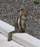 I also managed to get a photo of this little fellow. It’s unfortunate, but people at national parks find it necessary to feed the wildlife. As a result, they become tame, like this guy probably was, and they forget how to forage for themselves. In the winter, when there are fewer tourists around, they starve. That is if they don’t get sick and die from the junk the tourists feed them.
I found a restaurant with table service at the Snow Lodge. I had a nice salad with warm goat cheese cakes on it. Tasty. Then I got back into the car and made my way out, before a new post Old Faithful eruption could start another traffic jam.
I followed the signs to Grant Village, crossing the Continental Divide twice along the way. At one point, I caught a glimpse of Yellowstone Lake. I was surprised — I didn’t remember it being so big. And I saw plenty of evidence of forest fires: where I’d first come into the park, near Old Faithful, and now as I left the park, driving toward the South Entrance. I passed Lewis Falls, on the Snake River, the first waterfall Mike and I had seen when we’d come into the park from the south years before. I clearly remember the fresh forest fire damage at the falls — there was nothing alive back then. Now the dead trees were still there, but new pines were growing in. It would take a long time for the park’s forests to recover.
 The road followed the Snake River down to Jackson Lake and Grand Teton National Park. The main feature of Grand Teton is the mountain with the same name, on the southwest side of the lake. It’s 13,770 feet tall, very rocky, and has a glacier not far from the top. In this photo, it’s the mountain that’s farthest away. It was after 3 PM and the sun was moving to the west, making it difficult to get a good photo of the mountains from the east. I followed the road, choosing the path that kept me close to the lake rather than the faster road that went direct to Jackson. A scenic drive.
I passed through the southern boundary of the park and, a while later, was approaching Jackson. By this time, I was exhausted. I’d left the top down most of the day and I had been slow-roasted by the sun. All I wanted was a clean, quiet motel room. I stopped about about a half-dozen places on the north side of town and was told that they only rooms left were either smoking or very expensive. I drove through Jackson, figuring I’d find a place somewhere outside of town, on the south side. Jackson, WY, is a tourist processing plant. Tourists go there, park their vehicles, and then proceed through a series of shops and restaurants and tourist attractions designed to wring their money out of them. I couldn’t believe the number of people on the streets. Traffic was horrendous. And I couldn’t understand what attracted these people, like flies to honey. The real tourist attraction was north of town, the lakes and mountains and wildlife. Gift shops and cheap t-shirt joints can be found anywhere. When I finally got out of town, I was glad I hadn’t found a room there.
I wound up at a motel along a creek, just where the creek merges with the Snake River. I took an upstairs room facing the creek. After getting some dinner at a restaurant 3 miles away, I sat on my patio with my maps and a bottle of wine, trying to figure out where I’d go next. I was on my way home — that was for sure. After nearly two weeks and over 3,000 miles on the road, I was ready for my own bed.