An escape from the heat takes my Jeep to the limit.
Since I got my Nikon D80 digital SLR a few months ago, I’ve rekindled my interest in photography. (For most people, it would be the other way around: rekindle interest, then dump huge sums of money on equipment they don’t need. But I have a tendency to go about things bass ackwards.) I’ve been wanting to do a few day trips to interesting places to see what images I can come home with.
And of course, with daily temperatures in the 100s (that’s the 40s for the rest of the world), any outdoor activity would have to be done in higher elevations, where it’s cooler.
So when I suggested a trip up to the Bradshaw Mountains by Jeep and Mike agreed it was a good idea, we didn’t dawdle. Within an hour, I had topo maps for all of Arizona back on my Garmin GPSmap 60c (Alaska had been on it from our recent vacation), ice and food in a cooler, and my camera and a change of clothes in a canvas bag. We were good to go.
The West Slopes of the Bradshaw Mountains
The Bradshaws are a small mountain range south of the town of Prescott, AZ. They start at Granite Mountain, just west of the town and stretch southeast toward Phoenix, ending just north of Lake Pleasant. Most mountains are in the 5000 to 7000 foot range, with plenty of deep valleys and canyons between them.
The Hassayampa River, which flows through Wickenburg — well, mostly underground, at least — has it source up in those mountains and it cuts a deep canyon not far from where Route 89 winds north from Yarnell to Prescott. I fly over the canyon routinely on my way to Prescott or Sedona from Wickenburg, so I know it well.
On the west side of the Bradshaws, the manzanita-covered slopes fall down toward the dry riverbed and nearby Weaver Mountains. That valley is high desert, with sparse vegetation and few shade trees. Up on top of the Bradshaws is the area most folks refer to as “the pines.” It’s where you can find tall pine trees and, in the winter, snow. The whole area is dotted with abandoned mine sites, connected by a network of unmaintained dirt roads and trails.
It was these mining roads that we wanted to explore.
The Drive
Mike, Jack the Dog, and I set off from Wickenburg at about 10 AM. It was hot — in the 90s — and partly cloudy. The usual monsoon season late morning weather. We headed northwest on Route 93, then north on route 89. We passed through Congress, AZ and climbed the west side of the Weaver Mountains to Yarnell. We made a brief stop for baked goods at Yarnell’s excellent Cornerstone Bakery, then continued on to Peeples Valley, where we stopped for gas. (I like having at least a half tank when we go off-road.)
 Just past Peeple’s Valley, we stopped for a while to photograph a herd of semi-wild horses. The horses are owned by the Maughan Ranch folks, who turn them out into a 40- to 80 acre pasture. While out there, the mares and the stallions get together. Eleven months later, there are foals. The foals have never been handled by people and are about as close to wild horses as you can get in a fenced-in area. There were about 40 horses out there when we stopped and at least a dozen of them were babies, not much more than 6 months old.
 I wanted to photograph horses in a natural setting, with desert mountains in the distance. But being the time of day it was — nap-time for a horse — they just stood around half asleep on their feet. The babies were curious about us and one, whose mother actually came up to the fence to say hello and get an ear rub, came close enough to touch. But, in general, it wasn’t the scene I was thinking about for photos. The 20 or so shots I took with various lenses were very disappointing. These shots, however, can give you a pretty good idea of the scene.
Off Pavement Windmills
We climbed back in the Jeep and continue on 89, heading toward Prescott. We passed through the three houses that comprise Kirkland Junction and through the town of Wilhoit. About a quarter mile past the Nowhere Inn bar, we made a right turn onto our first dirt road.
At this point, we were not following a regular map. Although the Prescott National Forest map has all the fire road numbers and is more up-to-date than any other map I know, we were using the topo map I’d fed into my GPS that morning. I had the GPS on and plugged into the Jeep’s cigarette lighter so I didn’t have to worry about running down batteries. I’d cleared a track log and was letting the GPS track exactly where we went. If you have a GPS and can load .GPX files into it, you can download the track log here. You can then retrace our steps with your GPS. But if you must have road numbers, I can pull them off the All Topo Maps software I use to look at my route on a map. According to the software, we turned off on road 72. I admit that I don’t recall seeing a sign.
We’d been on this road from Wilhoit before, so it was familiar. It was a sandy dirt road that wound down a hill to the Hassayampa River, a gentle drop of about 1000 feet in elevation. Along the way were two windmills and the turnoff to a relatively new shooting facility.
I like to photograph windmills. There’s something about windmills that I really like. It could be their devotion to duty, far away from civilization. It could be the way they squeal and creak in the wind, especially when a breeze blows just enough to get them moving. It could be that they’re remnants of the past that continue to serve in this modern day and age. Or it could simply be their utilitarian design: no frills functionality.
So we stopped at each windmill for a few shots.
The first windmill, the Orofino Windmill, was a non-functioning relic. Its blades were badly damaged, the bar from the windmill to the pump was half gone, and its vane was damaged by shotgun fire. It stood nearly motionless, like an aging sentinel for the empty cattle pens and dry water tanks around it. Beyond it, the monsoon season clouds blossomed and drifted in the otherwise blue sky. Just before we left, a breeze blew the vane, rewarding me with a satisfying squeal as the windmill’s head shifted 10° to the left.

 The next windmill, which was on the right, was in better condition and still functioning. It has no name on my map, but lies at the intersection of our dirt road with a much less-used road. There was a young black cow standing at the concrete water tank when we pulled up, but as soon as we opened the Jeep’s doors, it fled and we didn’t see it again. The windmill spun lazily in the breeze, not making a sound. It was obviously well greased and well cared-for.
Across the River and Up the Wash
A short time later, we dropped into the Hassayampa River basin. The riverbed was completely dry. The area where the road meets the riverbed is filled with huge piles of gravel. According to my map, they’re dredge tailings, probably from an old mine a short distance upstream. There are quite a few of them — obviously enough to put them on a map.
The road turns downstream here — upstream is a narrow, twisting canyon where no road can go. We followed it for a short distance, although our track diverges from the supposed road. Another road that crossed the riverbed branched off to the left and we followed it. Soon, we were in the narrow streambed of Buzzard Roost Wash, climbing up the side of a mountain. My map identifies it as road 9712E, although again, I don’t recall seeing a sign where we turned onto it.
We’d been on this road in the past, too. It’s an extremely narrow road — keep your Hummer at home. On much of the road, the vegetation crowded in on us. Branches scratched at the side of the Jeep, giving it plenty more “Arizona pinstriping.” (I had decided, not long after I’d bought the Jeep brand new in 1999, that I wasn’t going to fret about keeping the paint job nice. Good decision.) Because the road was mostly in a stream bed, the erosion was considerable. In a few places, the road was very narrow — better suited for ATVs than Jeeps. But we managed, even in the very tight spots, to keep the Jeep on its wheels.
We made a short stop at what my GPS told me was Buzzard Spring. We got out to look for the spring and, at one point, my GPS told me we were within 16 feet of it. But there wasn’t any water to be found and no large cottonwood trees, which usually betray the presence of year-round water in the Arizona desert. So we got back in the Jeep and kept driving.
We were probably on that road for at least 45 minutes, always climbing. There wasn’t anything interesting along the way, although there were one or two spots where we could get a view back toward the river. After a particularly narrow spot, we emerged at the top of the ridge where the road we were on intersected with another dirt road, labeled 667 on my map. We turned left, then stopped to consult the GPS map. The photo you see here is looking back toward the road we’d come up on (on the right) and the road we were now on (to the left).
The vegetation all around us was mostly holly and manzanita. The manzanita have dark red bark and small leaves. It’s a hard wood and is commonly used for perches in parrot bird cages because even hookbills have a hard time chewing through it. Although the bark is normally very smooth, I did find a bunch of trees with peeled, curling bark. There were also some pines, although I didn’t pay attention to what kind. Probably juniper — they were short like the rest of the bushes.
Following Ridges
We continued northeast along the ridge, making a few exploratory turnoffs but always returning to the “main” road. Up head, we faced another intersection with a choice of three roads. One (road 9708C) was marked as a “trail,” led off to the right, and descended back down into Slate Creek. This was not the direction we wanted to go. Another (road 9405Y) was also marked as a “trail,” descended back down to Buzzard Roost Wash (farther upstream from where we’d been) and then climbed up to another ridge and into the mountains. The continuation of road 667 was marked as an “unpaved road” and continued along the ridge were were on up into the mountains. While either of the ridge roads went where we wanted to go — they actually intersected 5 or more miles up the road — we thought “unpaved road” sounded better than “trail” and decided to stay on 667.
This turned out to be the wrong decision. Although the road started out easy enough, it soon reached a place where it climbed steeply up a hill. Years of erosion and Jeep/ATV traffic had loosened the rock on the road. So we were faced with a 45° upslope filled with gaping holes, huge rocks, and loose gravel. This was the kind of road that they would put on Jeep commercials if people actually drove their Jeeps places like this. But I don’t think the marketing companies want to scare away potential Jeep owners with roads like this.
I didn’t want to try it so I climbed out and Mike took my place at the wheel. He threw it into 4WD Low and attempted the climb. Four times. He churned up gravel with all tires and, on several instances, had at least one wheel a foot or more off the surface of the road. It was not pretty. Not wanting to damage the Jeep beyond the usual scratches and dents, we gave up. He backed up down the hill, found a place to make a U-turn, and we headed back to the intersection.
My only regret is that I didn’t take any photos.
Trails Can Be Roads
We turned onto the road marked as a “trail” on the GPS map. Mike was a little nervous about this. I reminded him that the GPS data was based on topo maps that were 20 or more years old. In that time, trails could become roads and roads could become trails. This turned out to be the right way of looking at it. The road was in pretty good shape — better than the one we’d climbed from the river — and after dipping down into a wash, climbed onto a ridge with lots of scenic views and more than a few turns to old mine sites.
 Although the road we were on curved to the left where it would dead-end just past the remains of the Jersey Lily mine, we turned right onto road 97B, which continued climbing up into the mountains. We made a brief stop at the site of the Big Chief Mine. The access road had long been overgrown with bushes and weeds, but we made our way forward on foot for a few hundred feet. Off to the right, on the side of a hill, we spotted the remains of an old wooden shack. The path to reach it was overgrown and we didn’t dare attempt it in shorts.
In general, the mine remains were pretty disappointing. We saw plenty of shafts — most of which were probably at least partially filled in to discourage exploration — but not much in the way of ruins other than the shack. But it wasn’t as if we were actively looking for the mines, either. We’d been on the mountain roads for several hours and weather was moving in. Even as we got back into the Jeep at the Big Chief Mine, thunder was rumbling close overhead — we were at almost 6,000 feet elevation — and raindrops were starting to fall. Mike wanted to get back on roads we could trust before the one we were on got too wet. Dirt roads in the desert sometimes get “snotty” when they’re wet; driving on them can be treacherous.
Lunch Break
 Finally, when it seemed as if we’d reach more well-traveled roads soon, Mike agreed to stop for lunch. It was 1:30 PM. Although it was still raining, we found a spot under a juniper tree where we settled down on the ground and opened the cooler. We don’t picnic with sandwiches, like a lot of people do. We picnic with deli department treats. That day, it was fresh mozzarella “medallions,” thinly sliced prosciutto, marinated whole artichoke hearts, green olives with garlic, and dry salami. Yum. While we ate, we watched the weather all around us. I took this photo of the area to the north; you can see the rain coming down in the vicinity of downtown Prescott, just beyond the hills.
We continued on our way, now driving down the side of the mountain’s arm, descending into a canyon filled with tall pines. We passed where the road we’d wanted to take intersected with ours and continued dropping down toward the Hassayampa River. We spotted the roof of a house, then passed by a chain link fence that protected the home from intruders. Civilization. Not very friendly.
We stopped for a moment at Scotty Spring where a cement tank was filled with water. I got out to rinse my hands from lunch. We spotted a camera fixed to a tree. Mike says they use them to monitor wildlife at the water source. We waved.
We attempted to drive down road 9403P, which went all the way down to the river. Sometimes there’s water in the river there and I was anxious to see if there were any wading holes. But our way was blocked by two fallen pine trees. Although we probably could have moved them with the towstrap I keep in the Jeep and the Jeep itself, it didn’t seem worth the effort. So we doubled back again to 97B and followed it to where it crossed the river. The crossing was completely dry. I reminded Mike that the last time we’d crossed there, we’d been on horseback and my horse had been afraid to walk in the water.
The End of the Adventure
 From there, we followed the road through the community of Ponderosa Park, finally ending up on pavement back on Route 89. We’d been on back roads for about 5 hours, exploring the high desert. The map shown here (click it for a larger view) shows the terrain we covered.) We were tired. I turned left and headed back to Wickenburg.
I didn’t get the pictures I wanted. I was looking for more dramatic scenes, more dramatic landscapes. The 64 photos on my camera’s card were disappointing.
But that doesn’t mean I won’t try a trip like this again.
Like this:
Like Loading...
 PhotoJeeping is like photowalking, but done in a Jeep. Sure, you get out and do some hiking now and then, but most transportation is by Jeep or other 4WD vehicle. I covered 40 miles yesterday, roundtrip, in about five hours. I made stops at a number of mining sites and more than a few “scenic” areas near the road. And, for the first time ever, I drove all the way out to the Williams Family Ranch on the Hassayampa River.
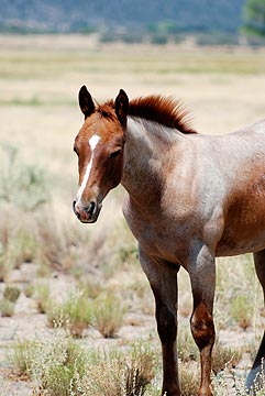 Just past Peeple’s Valley, we stopped for a while to photograph a herd of semi-wild horses. The horses are owned by the Maughan Ranch folks, who turn them out into a 40- to 80 acre pasture. While out there, the mares and the stallions get together. Eleven months later, there are foals. The foals have never been handled by people and are about as close to wild horses as you can get in a fenced-in area. There were about 40 horses out there when we stopped and at least a dozen of them were babies, not much more than 6 months old.
 I wanted to photograph horses in a natural setting, with desert mountains in the distance. But being the time of day it was — nap-time for a horse — they just stood around half asleep on their feet. The babies were curious about us and one, whose mother actually came up to the fence to say hello and get an ear rub, came close enough to touch. But, in general, it wasn’t the scene I was thinking about for photos. The 20 or so shots I took with various lenses were very disappointing. These shots, however, can give you a pretty good idea of the scene.
 The first windmill, the Orofino Windmill, was a non-functioning relic. Its blades were badly damaged, the bar from the windmill to the pump was half gone, and its vane was damaged by shotgun fire. It stood nearly motionless, like an aging sentinel for the empty cattle pens and dry water tanks around it. Beyond it, the monsoon season clouds blossomed and drifted in the otherwise blue sky. Just before we left, a breeze blew the vane, rewarding me with a satisfying squeal as the windmill’s head shifted 10° to the left.
 The next windmill, which was on the right, was in better condition and still functioning. It has no name on my map, but lies at the intersection of our dirt road with a much less-used road. There was a young black cow standing at the concrete water tank when we pulled up, but as soon as we opened the Jeep’s doors, it fled and we didn’t see it again. The windmill spun lazily in the breeze, not making a sound. It was obviously well greased and well cared-for.
 We were probably on that road for at least 45 minutes, always climbing. There wasn’t anything interesting along the way, although there were one or two spots where we could get a view back toward the river. After a particularly narrow spot, we emerged at the top of the ridge where the road we were on intersected with another dirt road, labeled 667 on my map. We turned left, then stopped to consult the GPS map. The photo you see here is looking back toward the road we’d come up on (on the right) and the road we were now on (to the left).
 The vegetation all around us was mostly holly and manzanita. The manzanita have dark red bark and small leaves. It’s a hard wood and is commonly used for perches in parrot bird cages because even hookbills have a hard time chewing through it. Although the bark is normally very smooth, I did find a bunch of trees with peeled, curling bark. There were also some pines, although I didn’t pay attention to what kind. Probably juniper — they were short like the rest of the bushes.
 Although the road we were on curved to the left where it would dead-end just past the remains of the Jersey Lily mine, we turned right onto road 97B, which continued climbing up into the mountains. We made a brief stop at the site of the Big Chief Mine. The access road had long been overgrown with bushes and weeds, but we made our way forward on foot for a few hundred feet. Off to the right, on the side of a hill, we spotted the remains of an old wooden shack. The path to reach it was overgrown and we didn’t dare attempt it in shorts.
 Finally, when it seemed as if we’d reach more well-traveled roads soon, Mike agreed to stop for lunch. It was 1:30 PM. Although it was still raining, we found a spot under a juniper tree where we settled down on the ground and opened the cooler. We don’t picnic with sandwiches, like a lot of people do. We picnic with deli department treats. That day, it was fresh mozzarella “medallions,” thinly sliced prosciutto, marinated whole artichoke hearts, green olives with garlic, and dry salami. Yum. While we ate, we watched the weather all around us. I took this photo of the area to the north; you can see the rain coming down in the vicinity of downtown Prescott, just beyond the hills.
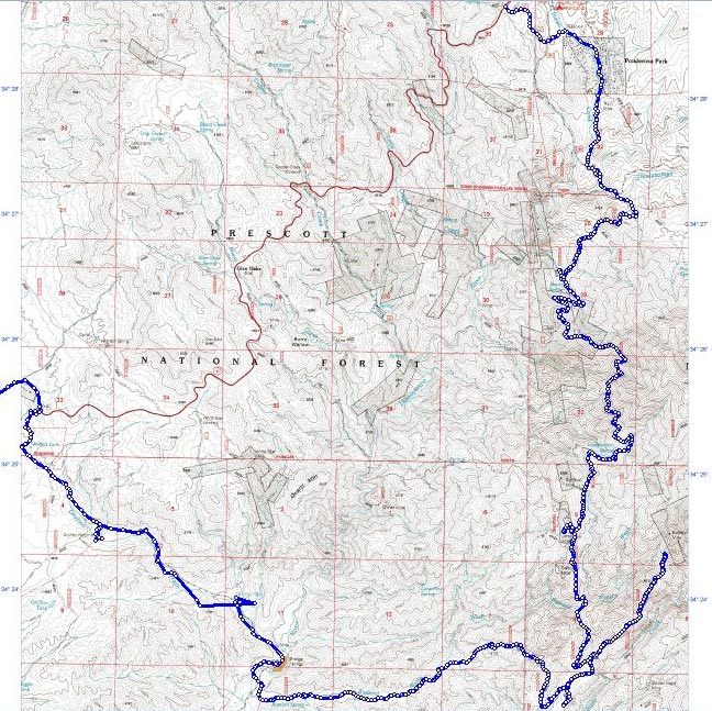
 The road crossed the tracks at a place called Willaha. Formerly a train station, the site has the ruins of a building, foundations of at least one other building, and a huge cattle holding pen overgrown with grass and weeds. I could imagine ranchers moving their cattle to this spot, putting them into the pens until the train with cattle cars stopped at the station. Then the cattle would be moved up onto the train and brought to market. Nowadays, the only train that uses the tracks is the Grand Canyon Railway, which runs one or two trains a day on scenic rides between Williams and Grand Canyon. I don’t think any cattle have passed through the corral in years, if not decades.
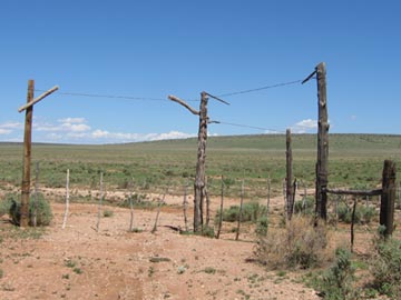 Back at the tracks, I took a left, heading northbound on a two-track road on the west side of the tracks. This road was not on my map, but it was on my GPS. It was easy enough to follow, although it did have quite a few gates to pass through. Most of them were drag gates, like the three-way gate shown here. You may have heard this type of gate referred to as a “cowboy gate” because they’re relatively common out on the range where only the cowboys go.
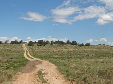 The road followed the tracks north. In most places, it was both smooth and dry. But in some places, water had gathered in the wheel ruts and that water was muddy. I drove through the first spot like that and managed to get mud all over the Jeep as I slid around in the muck. The next muddy spot I reached showed evidence that someone else had driven around it, so I did the same. In other places, the road climbed up a rocky outcropping and got rough with broken rocks, forcing me to slow down. I certainly didn’t want to break a tie rod or something out there.
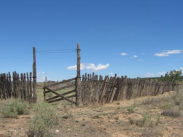 We reached Anita Station, where several roads intersected at the remnants of another cattle pen. Jack and I got out and walked around a bit. I saw the remains of several other buildings, reduced to mere concrete slabs. It was already close to 11 AM and I expected the train soon. But I couldn’t hear it coming, nor see its black smoke on the horizon. I decided to continue up the two-track road.
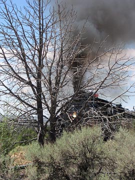 I heard the train coming and returned to my photo spot. As the train came puffing into view, I realized I’d picked a terrible spot for photos. I was too close to the tracks and there were too many trees in the way. For some reason, I’d imagined the train being bigger. It wasn’t. I offer this photo as an example of a good plan gone bad. I laughed at myself as the train passed and I walked back to the Jeep.
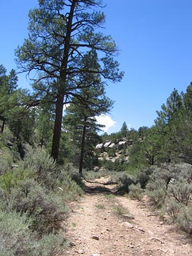 The canyon and road ended at an intersection: FR 2615 again. I wanted to go north, to the other side of the tracks. So I turned left. I realized about two miles down the road that left was wrong — it would just bring me back to the mud puddle — and backtracked yet again. I headed northeast on FR 2615, following it up Rain Tank Wash. The open meadow-like area closed up to another canyon and I followed the road through it. Although my map showed that the road ended not far after I’d gotten on it, I had become accustomed to roads continuing beyond their map ends. This one continued for a good two miles up the wash while steep walls and pine trees closed around us.
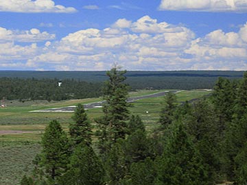 The road reached a clearing where the earth dropped away in front of us. There, in the near distance, was the approach end of Runway 3 at Grand Canyon Airport.