Arizona to Washington by Helicopter, Again

About 950 nautical miles in one day.

I flew commercial down to Arizona on April 11 to pick up my new old helicopter, N7534D. If you missed my blog post about my purchase process and what went into the decision to buy this helicopter, you can find it here. This blog post pretty much picks up where that one left off.

Flying South

I treated myself to a first class ticket, which I sometimes do when I’ve got a job ahead of me that might or might not be difficult. And instead of departing Wenatchee on the 5:55 AM flight, which, via a connection through Seattle, gets into Phoenix at 10:43 AM, I took the 11:35 AM flight with a connection at 1:42 to arrive in Phoenix at 4:30. Unfortunately, weather moved into Seattle that morning and they delayed our flight from leaving Wenatchee. For a short time, it looked like I’d miss my connection. But Alaska Air had my back (at least this time). Not only did they automatically add a booking on the next flight to Phoenix, but they made sure they gave me a first class seat there, too. So even if I missed my flight, I’d travel in the comfort I paid for.

Flying First Class
I had the salad. It was good. And have I ever mentioned how much I enjoy flying First Class? (Another perk of the single lifestyle; only one plane ticket to buy means airline travel is more affordable.)

But I didn’t miss the connection. I was the third to last person on board. I felt bad for Penny since I didn’t let her out of her bag — as I usually do — when hurrying across the airport to make the connection. She settled under the seat in front of me, still in her bag, on the Seattle to Phoenix flight while I settled in to a spacious and comfy seat and accepted the lunch menu the flight attendant handed me.

I enjoy flying First Class on Alaska Air. (Not so much with other airlines.) The food is always good and they have an excellent Bloody Mary mix. The seats are very comfortable. And I’ve discovered that the best way to make a long flight shorter — no matter where you’re sitting — is to watch a movie on a tablet. This time, I watched Coco, which I highly recommend.

Some Lurking Stress

Watching the movie also got my mind off the stress of my upcoming meeting with a new helicopter. There were a few things feeding it.

First, I hadn’t flown since my accident back on February 24. That was about six weeks. I’ve gone a lot longer between flights — heck, I went from December 4, 2017 to February 15, 2018 (ten weeks) and October 30, 2016 to February 22, 2017 (nearly four months) — but this was different. It was the elephant in the room — my crash — and the uneasiness was growing on me every day.

Logically, this didn’t make sense. I knew what caused the crash and I could easily prevent it from happening again. I had no uncertainty about my skills or the aircraft. But I think the people who were encouraging me to “get back in the saddle” were starting to make me wonder why they thought I wouldn’t. Maybe I was missing something?

This nagging concern got to a head about a week before I was supposed to pick up the helicopter. I actually asked Paul, the Director of Maintenance at Quantum who was handling the sale, to schedule a flight instructor to fly with me for about an hour before I left with the ship. Why not get a little refresher?

The other stress had to do with my route home and the weather. I’d been thinking a lot about my route for the flight and even blogged about the pros and cons of each option. I was very motivated to minimize flight time, but I was not interested in crossing the vast emptiness of central Nevada, which was the shortest route. And then there was a perceived need to go through California to pick up my old cockpit cover and floor mats, which were still in the custody of the aircraft salvage guy.

The trouble was, the forecast was calling for crazy high winds on Thursday and Friday. A front was coming through on the night of my arrival and the forecast was showing winds as high as 40 miles per hour. Although I tried to change my schedule to come in early on Wednesday for departure the same day, hoping to beat the winds out of the area, it was pretty clear that I would hit those high winds somewhere on my route . Besides, the helicopter wouldn’t be ready. The earliest I could pick it up would be Thursday, right when those high winds were scheduled to really ramp up.

Normally, a day or two delay wouldn’t matter. After all, I was staying with some friends in Gilbert, AZ and it was always nice to hang out with them. But on this trip, I’d be accompanied by my good friend Janet, who would then stay a day or two with me in Washington before flying back to Phoenix on Alaska Air. Her 5:55 AM Tuesday ticket could not be changed and I was really hoping to have her as a guest for more than just a day. In addition to that, I had some freshly hatched chicks in the brooder of my chicken coop and didn’t like the idea of leaving them for longer than absolutely necessary. Leaving Phoenix on Saturday would probably mean getting home by Sunday. And there was unsettled weather forecasted for northern Oregon and Washington on Sunday that could delay us further.

So the long flight home and weather-related delays were stressing me out, too.

And then there was the added stress of flying a helicopter that wasn’t mine. How would it fly? What would it sound like? I knew every quirk in the late, great Zero-Mike-Lima but didn’t know this one at all. (And yes, every aircraft has quirks.) That was made a little worse by a friend suggesting that there might be issues with the “rigging” (WTF?) and that I should fly it around locally before leaving the area in case anything needed to be fixed. More delays?

I kept telling myself that with Paul in charge of maintenance and the aircraft always being owned by Quantum, there wouldn’t be any mechanical issues. There was no way Paul would let an aircraft go that wasn’t perfectly safe and functional. That’s why I’d bought this helicopter instead of one of the other options — it came with peace of mind. Quirks were quirks and I’d figure them out over time.

Still, all these little things were accumulating in my brain, giving me more stress than I really should have had. Fortunately, I was able to switch off that stress on the flight to Phoenix and for the rest of the evening, which I spent with my friends.

The Pickup

The forecast was right. The wind kicked in on Thursday morning. I still had hopes of picking up the helicopter and getting it to Wickenburg — which is where I’d be meeting Janet — before things got too rough, but Paul texted to say that they’d found a small problem with the radios and the avionics guys still had to do their inspections. So I waited at Falcon Field, the Mesa airport where my friends have a flight school, watching the flag I could see through the window. The wind got rougher. They started cancelling their flights.

We went out for Thai food for lunch. Then back to Falcon Field. The helicopter was ready, but I probably couldn’t fly away. Still, I had paperwork to do and there were a few things I could do to prep the helicopter for its departure. My friends gave me their car keys. I loaded Penny up and we drove to Chandler.

The wind was very bad there. And because Chandler is close to the edge of the desert, the blowing wind had kicked up a lot of dust. Visibility was down to about a mile: IMC (Instrument Meteorological Conditions). No one was flying. Quantum’s door was locked with a sign to knock. When the girl at the desk came to open it for me, she explained that the wind and air pressure made the door swing open if it wasn’t latched.

I saw Paul and Doug and Neil, all of whom I’ve known since my primary flight training days in the late 1990s. We did the socializing thing. Then Paul brought me out to see the helicopter I’d come to buy. It was optimistically hooked up to the tow cart, parked right in the middle of the hangar.

First Look at N7534D
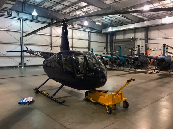
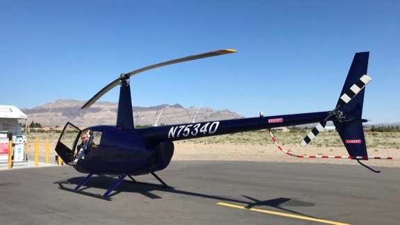
N7534D was waiting for me when I arrived. And I don’t know why, but almost every photo I take with my iPhone makes the helicopter look black. It isn’t. It’s actually a dark blue with a flat black stripe. Also parked in the hangar: at least three R22s that I’d flown during my flight training in 1998 through 2000; two of them have over 20,000 hours!

I went over for a good look. When I opened the pilot door and looked at the interior all worries about it not being my helicopter were washed away. It was virtually identical to Zero-Mike-Lima, from the tan carpeting and leather seats to the layout of the instrument panel. The only difference I saw — and didn’t even notice until I was nearly home — is that the Hobbs meter and clock are switched on the instrument panel. Paul had even installed the bar across the footwell on the pilot’s seat where I’d use RAM mounts to install my phone and iPad.

There were differences, of course. The gyros, which switched on automatically when Paul turned on the master switch, were louder. The glass on a few of the instruments looked a little hazy. There were tiny bits of damage on the pilot seat, almost like cigarette burns. Just enough to remind me that it wasn’t Zero-Mike-Lima. But it was close enough that any worries I’d had about flying again immediately went away. Of course I could fly this.

Penny in N7534D
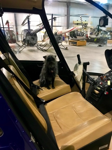
Penny wanted to sit in the helicopter so I put her in there. Note that I’ve already got my hat hung on the cyclic. Home sweet home?

I put Penny in the front passenger seat, where she really wanted to sit, and did a walk-around with Paul. He answered any questions I had. Then I took the canvas bag I’d brought with two headsets and my RAM mounts and began setting up the cockpit for my flight. It was a real relief to see that the helicopter had been hardwired for Bose headsets, since the ones I use in the front two seats are Bose without battery packs.

Meanwhile, Paul gathered up the paperwork and other things that came with the helicopter. This included a brand new, still in its original packaging, full cockpit cover, blade tie-towns, and ground handling wheels. (All of a sudden, I had no pressing need to fly though California on my way home.) I stowed all of it under the rear seats so I’d have plenty of room for luggage on top of the seats.

Sometime while all this was happening, I handed over the big certified check I’d picked up from the bank the day before. The purchase price did not include the cost of the USB ports Paul had put on that bar to keep my iPad and phone charged in flight and a few other things, so I fully expected to pay a bit more. But I did have money on account with Quantum for Zero-Mike-Lima’s core returns during overhaul the year before. So they cut me a new check for $700+, which I actually forgot about until I found it just yesterday.

Back in the office, I filled out forms and signed papers. I chatted with Paul and Doug and Neil. I looked out the door and saw the thick blowing dust. I knew damn well I wouldn’t be flying to Wickenburg that afternoon. I told them I’d be back in the morning, probably around 7:30 AM. Although the wind was supposed to pick up again, I was hoping I could get it out of the Phoenix area before that happened.

Then I hopped back into my friend’s car and went back to Falcon Field, stopping for a DQ hot fudge sundae along the way.

Chandler to Wickenburg

I spent a second night with my friends in Gilbert. We went to the Monastery, a local pilot hangout, for drinks after work, when back to their house for leftover Chinese food. It was nice to relax. I felt good about my upcoming trip, although I still didn’t know when I’d be able to head out beyond Wickenburg and which route I’d take. Heck, I wasn’t even sure I’d be able to leave Chandler.

But in the morning, the wind was relatively calm and the sky was clear. I had coffee with my friends, turned down their offer for a ride to Chandler Municipal because I didn’t want to wait or have them drive so far out of their way on the way to work, and caught a ride with Lyft instead. I was at Quantum’s unlocked door at 8 AM.

Doug came in just as I was heading to the hangar with my wheelie bag with Penny in trail. But the helicopter was gone. One of the guys in the hangar told me they’d put it outside for me. The big hangar door was closed. I went through a man door to the ramp. N7534D was parked right there on one of the pads.

N7534D
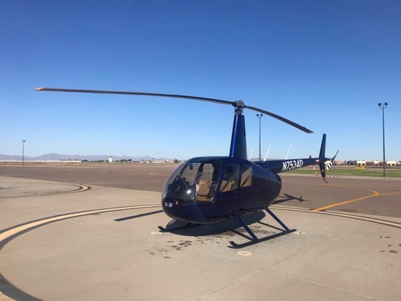
It almost looks blue in this photo. I should mention here that the N-number is painted on in the same black as the stripe. Can you see the stripe? Well, the painted N-number is just as visible. Because the FAA would definitely balk at that, Paul used decals cover them with the same numbers in white.

To my surprise, Penny ran right over to it. Well, why shouldn’t she? It was ours, after all.

I was pleasantly surprised to find a small pile of Quantum swag on the front passenger seat, including a slick-looking jacket, two tee shirts (one long sleeve and the other short sleeve), and two baseball caps. I put on the jacket — it was cold that morning! — and stowed the other things in my suitcase.

I put Penny inside on the front seat on the small dog bed I’d brought along for her. (She doesn’t like sitting on leather.) Then I loaded up the luggage and did a preflight. The oil dipstick, which is shorter than the one in Zero-Mike-Lima was, showed just under 7 quarts of very clean oil. Robinson are funny about oil. The manual says 9 quarts, but if you put in more than 7, it usually just blows it out when the engine is running. I kept Zero-Mike-Lima’s right at 7. I figured I’d check this one again when I got to Wickenburg to see if it got lower. But I did go back into the hangar and ask Doug if I could buy some oil. He gave me two quarts of W100Plus; according to the log book I had on board, that’s what Paul’s team had put in it. (It’s also what I’ve always used.)

By this time, the wind was about 12-15 miles per hour out of the northwest — just the direction I had to go. Out on the edges of the ramp, two or three R22s were practicing hovering right into the wind. It was blowing right up my helicopter’s tail. That meant my first pickup in this ship would be with a nice little tailwind. Nothing like getting back into the saddle — on an unbroke horse.

I got my iPad EFB all set up with my flight plan filed. Then I started it up. It caught on the second try; I knew it would be a while before I learned exactly how much priming I’d need in different conditions. The engine sounded different. The blades spun up silently — no squealing drive belts! The idle was low. When the needles matched, I had to add throttle to keep it at 55% RPM until the clutch light went out.

My mind noted all of these things automatically. It was different from Zero-Mike-Lima, but not wildly different. I listened to Chandler’s ATIS on the GPS radio while the engine warmed up. Although I felt as if I should be in a hurry, I reminded myself repeatedly that I was not. I dialed in both of Chandler’s tower frequencies on the main radio in case I needed to switch when I crossed the runway. I listened to the tower frequency; there was just one plane on the radio and he landed before I was ready to take off.

I brought the RPM up to 100% and carefully lifted the collective, mindful of that strong tailwind. My feet were firm on the pedals, prepared for the dance I might have to do. But if there was any dancing, it was instinctive. I picked it up off the ground smoothly with virtually no yaw or wiggle. I gave it some right pedal and turned around smoothly, pointing it into the wind.

Just like riding a bike.

I called the tower and asked for departure to the north. He asked if I wanted departure from present position or from the helipad. I told him I preferred present position; I really saw no reason to waste time or fuel hover taxing over to the pad. He gave me the usual “departure is at your own risk” disclaimer and cleared me northbound over both runways. Somewhere during our exchange, I used the wrong N-number and quickly corrected myself, adding “new helicopter.” Then I was airborne above and between the two light posts on the north edge of the helicopter parking area, climbing away from Quantum.

I took one of my “usual” routes to Wickenburg — north just outside of the Phoenix surface airspace, then west along Camelback Road, then northwest direct to Wickenburg. I hit some moderate turbulence between Camelback Mountain and North Mountain that were likely caused by wind over the mountains north of me, but that cleared up by the time I passed Piestewa (formerly Squaw) Peak. There was a little more turbulence along the way. Otherwise, it was a pretty uneventful flight. I skirted around the special Luke Air Force base surface training area southeast of Wickenburg so I wouldn’t have to talk to Luke Approach. The flight path was familiar — I’d flown it at least a hundred times when I lived and flew regularly in Arizona.

Chandler to Wickenburg
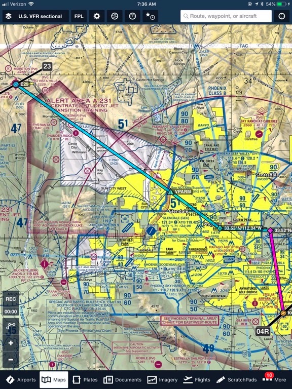
My route from Chandler (CHD) to Wickenburg (E25) on Friday morning.

When I got within radio range of Wickenburg, I flipped on the AWOS on my second radio. Winds were 15 gusting to 23. Whatever. I flew over my old house — which I have to say looks a hell of a lot better than when I lived there with my wasband — but didn’t see any sign of Jeff or Mary, who now live there. I came in over the golf course and made a short right base to the taxiway parallel to Runway 23.

I set down temporarily near the taxiway as my friend (and insurance agent) Dave towed his helicopter past on a cart for departure from the helipads on the far west end of the ramp. Then I hover-taxied over to one of the two fuel trucks parked near the big fuel tanks adjacent to the parking area and shut down. I caught Dave on the radio just as he was taking off. “I thought the new helicopter was red,” he said as he made his departure toward Scottsdale.

I’d hear that a lot over the next few days, and likely in weeks to come.

Overnight at Wickenburg

I got fuel and although I’m tempted to tell you the saga of the Town of Wickenburg’s stupidity at installing a costly fuel system that won’t work property, I won’t waste your time or mine. Short version is, fuel came from a truck that can’t move and when fueling was done, I was told I couldn’t keep the helicopter parked there overnight, despite the fact that I’d purposely parked it out of the way. Okay. I wasn’t sure if I’d be spending the night anyway. I was told I could park there until noon; if I needed to stay longer, I’d have to move it. Fair enough.

The good news is, the fuel was only $3.95/gallon. They’re trying to empty the tanks so they can get them fixed in June. The bad news is, it was a short flight so I didn’t need much fuel to top off both tanks.

I called my friend Janet to come get me, then locked up the helicopter. That’s when I discovered that the front passenger door wasn’t seated quite right. I suspect that whoever put the swag into the helicopter that morning had let the door get caught by that tailwind. It would need some work with a screwdriver and pair of pliers to fix it. I also discovered that that door lock was kind of funky; normally you turn the key 1/4 turn to lock it but this one has to turn 1/2 way around.

Remember what I said about quirks? I was learning them.

I went to a late breakfast with Janet in town. While there, I checked the weather. No matter which way we went, we’d hit high winds that day. So after breakfast and a few errands, we stopped at the airport so I could reposition the helicopter on a far east ramp that hadn’t existed when I was based at Wickenburg. We used the brand new blade tie-downs and the tailgate of her truck to secure the blades against the wind. Then we headed out to the off-the-grid ranch she and her spouse, Steve, and their animals were living at.

The wind howled all day, making it very unpleasant outside. We chatted in the living room of the fifth wheel they now live in full time. I made a piece of jewelry. She read. We met with Steve when he returned from riding drag on a horseback ride for four city slickers. Janet cooked the pizza we’d picked up at the supermarket.

Meanwhile, I kept checking the weather — I had a barely acceptable connection on my iPad that switched from 3G to LTE — and thinking about routes. We planned to depart by 8 AM the following morning. I was starting to lean toward the one route I hadn’t completely done before: the western Nevada route. The weather looked doable, but I didn’t like the forecast nearer to home for Sunday. I’d want to get as far north as possible before stopping for the night.

I left them to spend the night in the little travel trailer they’d bought for small trips Janet often needs to make throughout the year. I had the whole place to myself and slept like the dead.

The Long Flight

I was already awake when the generator went on just before 6 AM. I immediately plugged in my iPad, then went out in search of coffee.

By this time, I had pretty much decided on the western Nevada route, which would save at least 2 hours over the California route. Time is money, especially when flying a helicopter.

Both Janet and I were ready to go at 6:30, so rather than sit around and waste time, we loaded up the truck and let Steve take us to the airport.

Using the truck tailgate again — I really do need to get my collapsible stool on board — we pulled off the blade tie-downs. I did a preflight and added a quart of oil, kind of surprised to see that there was absolutely no sign of dripping under the ship. (Most Robinsons let a few drops of oil go from the drain port when parked; this was a quirk I could certainly live with.) Then we loaded up all the luggage, moved Penny’s bed to the back passenger side seat, and prepped to go. Steve watched us start up and take off.

I flew over my friend Jim’s house but saw no sign of life.

Then we were on course northwest bound, heading 301° toward our first fuel stop in Pahrump, 209nm away. We were originally supposed to stop at Jean for fuel — that’s just southwest of Las Vegas on I-15 — but unlike too many other pilots, I did read the NOTAMs, which informed me that there was no fuel at Jean until June. (I didn’t believe the NOTAM, so I called the phone number and got connected with someone at Henderson Executive Airport who confirmed there was no fuel.) Seriously, pilots: read the NOTAMs. (There’s also this old blog post about an idiot pilot who didn’t read the NOTAMs and unsuspectingly flew into a busy airport hosting an EAA Young Eagles event.)

Wickenburg to Pahrump
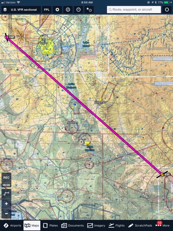
Our route from Wickenburg (E25) to Pahrump (74P) cut through miles of empty Arizona and Nevada desert, crossing the Colorado River at the south end of Lake Mohave.

Our flight path put us just east of Route 93 to the west of Alamo Lake. And that’s the only place we hit turbulence — a pretty good roller coaster ride as we passed near some hills about 10 minutes out of Wickenburg. My first thought was: this better not be an all-day thing. Janet later told me that it bothered her a lot more than she let on. I suspect that’s because after many years of flying with passengers in all kind of conditions, I’m very careful to never look annoyed or scared in turbulence or other weather-related conditions. Passengers take their cue from the pilot; if the pilot doesn’t look bothered, there’s obviously nothing to worry about.

There were pilots landing at the dirt strip out at the Wayside Inn south of Lake Alamo. I didn’t see them, but I heard them on the radio. Weekend pilots, meeting up for breakfast. I wished, in a way, that we could stop and join them.

We passed the old grid of lots in the big, broad valley east of Crossman Peak (east of Lake Havasu). It’s flat and sparsely populated and I can bet it was full of blowing dust the day before. I’d been over the area before and was always amazed that people would buy land all the way out there. It had to be 10 to 20 miles or more on graded dirt roads to get to any pavement in any direction. And even then, where was the closest town with a supermarket and other services? Needles, NV? Kingman, AZ? People think I’m crazy living 10 miles from the nearest supermarket but that’s only because they haven’t seen these middle of nowhere homes. It’s all relative.

I talked briefly to Bullhead City’s tower, telling them I wanted to transition on the east edge of their space northwest bound. Then we crossed the Colorado River just upstream from the Davis Dam, at the south end of Lake Mohave. We had entered Nevada.

We crossed a few more mountains and I climbed to avoid the possibility of mechanical turbulence. It also gave me a chance to play with my radio altimeter (which I never wanted). As I consulted it periodically through the trip, I soon learned that it lagged in its readout of altitude changes and would be, as I suspected, completely useless in my operation. I’m sure the manufacturer of the device is still patting itself on the back for successfully lobbying the FAA to require them. How much additional revenue have they managed to squeeze out of VFR pilots who don’t need such a device for safe operation?

We passed to the east of Searchlight, NV; I saw it’s huge American flag fluttering in the breeze.

Janet pointed out the big solar farms in California near Primm. I remembered driving past those on I-15 just a few weeks before. They use mirrors to focus sunlight on a tower that heats oil (I think) to run a turbine and generate electricity. As the VFR sectional chart for the area warns, there’s the possibility of “ocular glare” from the tower which glows brightly in the desert.

We passed over the top of Jean and kept going. We could see Las Vegas off in the distance. Then we were flying up the valley west of the Spring Mountains and Mount Charleston, over Pahrump for landing at Calvada Meadows (74P).

Of course, just before landing, there was a guy on the radio who reported in at about the same position we were. I tried to get him to provide his altitude or other information that would help me spot him, but he had a heavy accent and I think he was having trouble understanding me. I kept slowing down and flying lower and lower; helicopter pilots know that airplanes generally don’t fly below 500 feet AGL. Finally, I was abeam the airport and needed to fly across the runway. I looked both ways and darted across. It wasn’t until we’d taxied up to the weird little fuel ramp that Janet pointed out a powered hang-glider — is that what you call those things? — about a mile from the airport. I don’t know where he landed, but it wasn’t near us.

N7534D at Pahrump
Here’s Janet, sitting in the front passenger seat at Pahrump. Okay, so it looks blue here. Kind of.

I let Penny out and fueled up while Janet used the restroom, which was an ancient looking port-a-potty. She said it was pretty gross. I had to go so I wound up using it. I’d been in a lot worse ones than that.

A small twin came in and pulled up behind me on the one-lane ramp. A car came out to meet him. By the time I’d checked the oil — which seemed low but was hard to read because it was so darn clean — and was ready to go, he was parked on the dirt beside the ramp. There are tie-downs there and I hadn’t even seen them.

We took off and continued northwest, now heading 307°. Our next planned fuel stop was Hawthorne, NV, only 186nm away. I had originally been worried about making this leg from Jean, but when we switched to Pahrump, the distance got shorter. We probably could have stretched the leg out to Silver Springs. But I had already told my friend Jim to let our mutual friend Betty at Hawthorne know that we were coming. So with Betty expecting us, I had to stop there.

Pahrump to Hawthorne
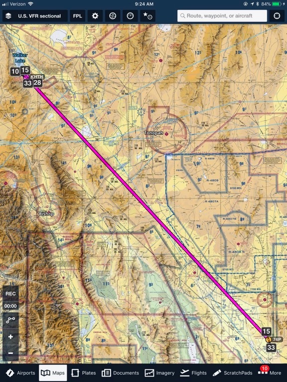
Our route from Pahrump (74P) to Hawthorne (HTH), NV took us over some pretty barren desert.

The stretch between Pahrump and Hawthorne was pretty remote and kind of dull, especially when you’ve already spent hundreds of flight hours low-level over southwestern desert. The only highlight I can think of was near Beatty, NV, when I drifted off course and Janet caught sight of the old ghost town of Rhyolite. I’d been there on the ground twice and this time I dropped down to fly over it so Janet could have a look. Then we climbed out of the dead end valley, over some hills, and into the area known as the Sarcobatus Flat, just west of route 95.

The terrain was typical desert with a mixture of rocky outcroppings, eroded hillsides, dry lake beds, and sand dunes. There were few roads and even fewer paved roads. We caught sight of another Solar Farm off in the distance to the east. We skirted around mountains rather than going over the tops of them. My GPS showed a tailwind that ranged from 5 to 20 knots. There was no turbulence.

It wasn’t long before we were descending over the hills and old munitions storage areas to the town of Hawthorne, with Walker Lake beyond it. Although I’d driven through Hawthorne at least twice — most recently in late 2016 — I’d never flown in and had trouble finding the airport. But then I saw it and with almost no wind came in for landing on the ramp near the very large and impressive fuel island. Betty, who had heard my radio calls, was waiting in a golf cart to greet us. It was about 11:30 AM.

If you’ve never stopped at Hawthorne, it’s worth it just to meet Betty. I don’t know how old she is, but she’s probably got at least 15 years on me. She’s tiny and she knows everything about the airport and most of the aircraft that come and go. My friend Jim, who used to fly for Continental (and then United) met her on a cross-country trip in a general aviation aircraft with a friend and became friends with her. He used to talk to her from 30,000 feet when he overflew the area in a jet. (Ever wonder how pilots kill time in the cockpit on those commercial flights?) She’s not an airport employee — she’s a volunteer — but she’s worth her weight in gold and is more enthusiastic and helpful than just about any airport employee I’ve ever met.

After helping me figure out the quirks in the fuel system and chatting with us as I fueled, she drove us over to the FBO building and handed over the keys to the courtesy car. We drove over to McDonalds to grab a quick lunch from the drive up window and brought it back to the airport to eat. Betty kept us company, telling us about her new Doberman puppy. Then, after an hour had gone by, I reminded everyone that we had more distance to cover before nightfall.

Betty drove us back to the helicopter. I checked the oil and it looked the same. We loaded up and took off. Betty took pictures of our departure, which I fully expect to see in the newsletter she publishes every week.

N7534D at Hawthorne
Here’s N7534D, still not looking very blue, at Hawthorne. It was a gorgeous day there.

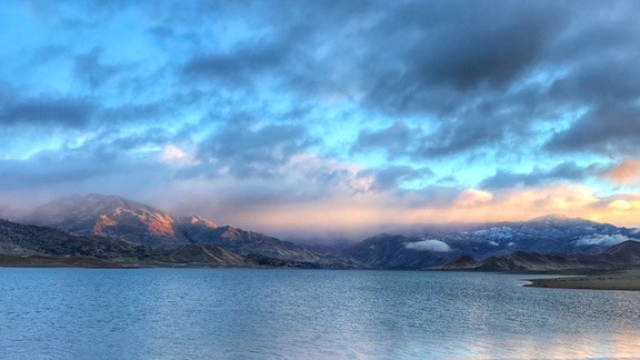
The next leg was from Hawthorne to someplace called Lakeview, on Goose Lake, just over the Oregon border on a heading of 326° for 231nm. We didn’t fly it exactly as planned. Instead, we went up the east side of Walker Lake and the west side of Pyramid Lake. (I really don’t like flying long distances over open water.) By the time we got near the Oregon border, we’d drifted so far west of our plotted course that we wound up west of Eagle Peak and the South Warner Wilderness area, which turned out to be a good thing.

Hawthorne to Lakeview
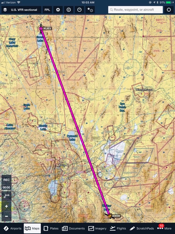
Here’s our plotted course from Hawthorne (HTH) to Lakeview (LKV). We wound up flying mostly a little west of this course.

Of all the legs of this journey, I think this was the most interesting — at least to me. I really enjoyed flying up the two lakeshores, especially up Pyramid Lake, which I’d never flown or driven by before. (My only Pyramid Lake experience was on my so-called “midlife crisis road trip” back in 2005, but I’d drive up the valley to the east of there, up the longest dry lake bed I’d ever driven along.) Looking down at the folks camping and fishing along the shore — especially near the town of Sutcliffe — I really wished I could just drive up with my truck camper and boat and join them.

After Pyramid Lake, the scenery got kind of dull and then interesting and then dull again. It’s the monotony of the desert terrain. Just when it starts to get boring, all of a sudden you notice a change and then it’s interesting again. In this area, it was most mostly weird colors and erosion patterns in the desert that caught our eyes.

And then, in the northeastern corner of California, just west of the South Warner Wilderness area, I caught sight of the first herd of wild horses. I pointed them out to Janet, who didn’t see them right away, and then lowered the collective, pulled back on the cyclic, and started a descending left turn to go back to them, putting them on Janet’s side. Thinking back on that moment now, the entire maneuver — which was far beyond the straight and level flying I’d mostly been doing all day — was done without a moment of thought. Heck, why not? How many times had I done the same thing in Zero-Mike-Lima? This helicopter responded exactly the same way and I didn’t give anything a second thought. I wanted to slow down, swing around, and descend for a closer look and my hands and feet did what needed to be done to make that happen.

Janet saw the horses and then another bunch and another. Soon we realized that the entire desert was covered with small herds of horses. Janet figures at least 50 horses, but I think there had to be over a hundred in the multiple groups I spotted from the air. I got back on course, feeling happy about it. After all, who doesn’t like seeing wild horses in the middle of nowhere from the air?

We passed to the east of Alturas, CA, and flew up the east shore of Goose Lake. The wind had picked up a bit but it was still a tailwind. We were making good time. I approached the airport, making all my radio calls, and came in from the west, landing into the wind in front of the fuel island.

The place was nearly deserted. There was a big hangar with its door open and a guy working inside on the shell of an old Huey helicopter. A partially disassembled R44 was parked beside it. Later, when I went in for a chat, I’d see that the R44 had bright red leather seats in perfect condition.

I fueled while Janet and Penny stretched their legs. Janet had been having some back pain and really needed to move around. I added that second quart of oil. I went to chat with the guy in the hangar — I really can’t remember why. I might have been looking for Penny. Then, with nothing much else to do, we loaded up and headed out.

The next leg was also short and it was supposed to be the last for the day: Lakeview to Madras, OR. I had already called ahead and discovered they had a courtesy car we could use overnight. I figured we’d fuel up, park, and drive into town for dinner and a motel room.

But it was still early in the day and sunset at home wasn’t expected until 7:50 PM. I wasn’t sure how long the leg from Madras to Malaga was, but it couldn’t be longer than 2 hours. If we got to Madras before 5 PM and I still felt fresh enough to fly, maybe we’d continue the trip and get home the same day we left. Was that even possible?

We still had to get to Madras, though. That was just 154nm away heading 337°. I took off into the wind and got right on course.

Lakeview to Madras
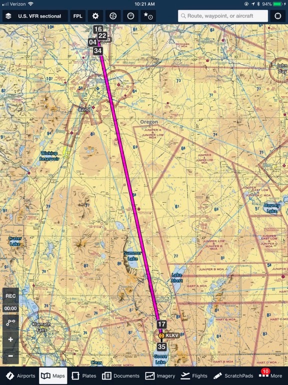
Our plotted course from Lakeview (LKV) to Madras (S33), OR. We pretty much followed this route exactly.

More boring desert mountains and valleys. Honestly, I was really done with it. It was only the lava fields that perked us up. They started when we were abeam the half-full Summer Lake and reappeared sporadically all the way to Redmond.

By the time we got near Redmond, we were back in civilization. We flew over a bunch of really nice homes along the river just east of Redmond that looked impractically large for anyone with fewer than a dozen kids but also beautiful. I talked to Redmond tower to tell them I wanted to transition along the east side of their airspace to Madras and got permission to do so. The only other pilots flying were flight school students with heavy Asian accents.

By this time, I was back over familiar ground. I’d flown Zero-Mike-Lima between the Wenatchee area and Bend, just south of Redmond, at least a dozen times. Although I had never landed at Redmond or Madras, I’d visited both on my midlife crisis road trip. (I really need to repost all the blog posts I wrote way back then and explain again why I made that trip.) Even though I was still quite a distance from home, I felt like I was close.

We touched down at Madras at about 4:30 PM.

Other than a backache from sitting in the same position for so long, I felt fine. I fueled up and worked Foreflight to plan the last leg of the trip. It told me the total flight time would be about 90 minutes. Shit. That was a no-brainer. I could certainly do another hour and a half of flying. We’d get home long before sunset, save the cost of a night in a motel, and be able to have a nice relaxing dinner at home. Best of all, I’d be able to sleep in my own bed and we could get an early start at fun things the next morning.

Janet agreed. Seriously, I think Janet is the best travel companion I’ve ever had. She’s realistic, adventurous, and has good ideas. And unlike one person I’ve traveled with extensively in the past — and he knows who he is — she doesn’t start an argument over every change of plans by saying, “But I thought we were going to….” [Insert eye roll emoji here.]

So after stopping in the very nice FBO to tell the woman there that I wouldn’t need the courtesy car after all, we climbed back on board and headed the rest of the way home. That meant steering 359° and flying just 166nm.

Madras to Home
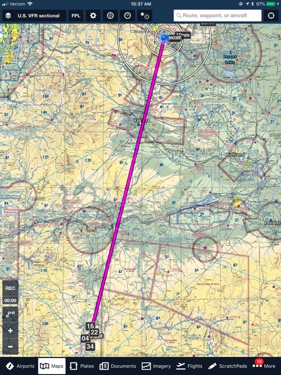
He’s the last leg of our trip, plotted on Foreflight.

This was mostly very familiar terrain. Although I’d flown this way before, I’d never started from Madras, so my flight path was a little farther west than it normally would be. We got great views of the Deshutes River that I normally don’t get. We still passed right over the top of Biggs, OR before crossing the Columbia River. That’s when Janet got her first glimpse of our extensive wind farms; there are literally hundreds of wind turbines between northern Oregon and the Wenatchee area.

I think it was on this leg that we started talking about a name for the helicopter. Janet names all her vehicles; I seldom name mine. But although Three-Four-Delta is pretty easy coming off the tongue, it just doesn’t seem quite right. We talked about naming it Blue or Blew or Bleu. Or one of those with “Mr.” in front of it. That got me thinking of the old ELO song, Mr. Blue Sky. Now that might seem like a deep cut to you, but I was an ELO fan and really loved this song — back in the 1980s. The chorus seems right:

Hey there mister blue
We’re so pleased to be with you
Look around see what you do
Everybody smiles at you

(Weren’t the 1980s grand in a funny sort of way? We were so innocent back then.)

Anyway, that’s what I was thinking of. I don’t think I mentioned it to Janet. I didn’t think she’d know the song. As I write this, I think Mr. Bleu might be a good name. Not Mr. Blue because the damn thing doesn’t look blue in most of the photos I take.

Meanwhile, the weather was deteriorating. The sun had been behind clouds for much of the previous leg of the trip and came out for a short time in northern Oregon. Then it slipped behind the clouds again. We caught a few glimpses of the top of Mount Hood but didn’t see any sign of Mount Adams or Mount Rainier, both of which would be in-your-face visible on a clear day. The only wind was a tailwind and there was no turbulence. But the farther north we got, the closer the clouds were to the ground. There was mountain obscuration west of Goldendale (hiding Mount Adams) and I started wondering whether we’d have to make any detours on our planned route.

Meanwhile, we saw wild horses on the Yakama Indian Reservation, which is no surprise to me. I always see wild horses there. There are actually stretches where you can see them from the road (route 97) when you’re driving though.

South of Yakima, I called the tower and told them I wanted to transition on the east side of their space. The controller cleared me and I continued north. I showed Janet where a big pieces of a mountainside has been sliding and will likely come down within the next few years, blocking the freeway and possibly the Yakima River there. (It’s been on the news.) The drop was pretty easy to see from the air.

Then we were flying up the Yakima River toward Ellensburg. When we flew over the last mountain ridge before the valley at Ellensburg, I could see the back side of Mission Ridge. The clouds were touching the ground there. I’d be crossing the ridge not far from there, but so far, it looked clear enough to keep going. So I did.

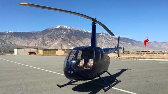
We climbed with the terrain, always staying east of where the clouds were touching the ground. I had hoped to come over Jumpoff Ridge just behind my home, but miscalculated and came over west of there, not far from Stemilt Hill. So I descended as I steered northeast, flying past my neighbors homes on the west end of the road to announce my arrival. The few that heard me told me later that they were happy to see me back with a replacement helicopter. (There are only a few Seattle-spoiled NIMBY assholes here who give me grief.) I showed Janet my home from the air and then came in for a landing at a neighbor’s home nearby. We’d already established a landing zone for me so I came right in and set down where I was supposed to.

Mr Bleu
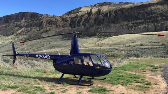
Mr. Bleu in its temporary parking space. I shot this the other day when I went back to put in its cockpit cover.

It was 6:30 PM.

We’d been traveling for just under 11-1/2 hours and, if you figure the time spent on fuel stops, the total flight time was about 9-1/2 hours. I was tired, but not exhausted. It was glad to be home, glad not to have to deal with finding a decent hotel room at a decent price at a place that wouldn’t give me grief about staying with a dog. And I was especially glad to not have to fly again in the morning. I had had enough.

We unloaded the helicopter and loaded up my truck. I used the tailgate to put on the blade tie-downs. I locked the doors. I’d put the cockpit cover on another day.

Ten minutes later, we were home and I was opening a bottle of sparkling wine to celebrate the new arrival of Zero-Mike-Lima’s replacement.

The Long Road Home

I make my way home from my winter travels, slowly but surely.

I’m writing this in my RV at a campsite in Maryhill State Park in Washington State. As I so often do when traveling through the area, I arrived late enough in the afternoon to stop for the night. Yes, home is only a 3-hour drive from here, but I don’t like driving at night. I have come to use Maryhill as a sort of post-trip celebration spot, a place I wind down from a long trip and start getting myself mentally prepared for my return to home.

As usual, the campground is nearly empty and I got a nice pull-through spot along the river. There’s electricity and a sewer dump at my site, but the water is still turned off for the winter. That’s okay; I filled up my fresh water tank in Las Vegas before I left and have plenty of water left.

Away from the Camper

Las Vegas is where I went after my helicopter mishap on February 24. My truck, camper, and boat were waiting there for me in a “storage” site at the Sam’s Town KOA. Although I generally avoid KOA camping, I really do like the one in Vegas for what it is: city camping. With my small rig, I can take one of the double-width sites along the edge of the campground property and not be right on top of my neighbor. I’d parked the boat beside the truck and camper before coming home in mid February to fetch the helicopter and take it down to California for a frost contract. I was able to plug in to power, which saved a ton of propane for the fridge, and the KOA folks charged only $15/day while I was gone. It was good to leave my stuff in a place I knew it would be safe.

The original idea was to go right back to Vegas after tucking the helicopter into a hangar at Yolo County Airport, but the weather in the Sacramento area turned cold and I wound up in a Woodland motel for a week in case I had to fly for frost control.

I spent my days goofing off, going as far as Calistoga for a mud bath and facial one day. (I am a sucker a good facial.) I managed to visit two wineries for tastings before heading back.

When I finally got to fly, the flight was very short with a bad end.

After being discharged from the hospital’s emergency room, my friend Sean took me to see the wreckage and we pulled out the last few personal possessions I had in there. (Sean had already collected quite a few things.) We stowed them in the hangar. Then I drove my rental car to Sacramento Airport, dropped it off, and waited in the terminal for a Southwest flight back to Vegas. With no helicopter or frost contract, there was no reason to stay in Woodland.

In Las Vegas

I was back in my RV by 6 PM. As you might imagine, I had a little trouble getting to sleep. Every time I closed my eyes, I’d see those damn trees in front of me. But putting the TV on seemed to help. And I eventually got a decent night sleep.

I took a full inventory of my bruises the next morning in the shower. That day — Sunday — is when the soreness really kicked in. I later learned that the helicopter impacted the ground at least twice before coming to rest against a small berm in the field where I crashed. I must have been like a rag doll in there with my muscles all tensed up from the adrenaline rush. (I don’t remember any of it, but without a head injury, I don’t think I passed out. It’s just blank.) Once my muscles relaxed a little, every single one of them got sore. The ibuprofen I was taking took the edge off.

I started the active part of my day by repositioning my truck, camper, and boat to a site on the south side of the RV park. It was a nice site with grass behind it — which is good since the camper’s door is in back. I hooked everything up — electricity, water, and sewer — since I’d be staying for the week.

I went to the convention center to meet up with my friend Zac from HAI (Helicopter Association International). The show wasn’t open yet, but he was in charge of guiding the helicopters in to land in the Convention Center parking lot. From there, they were wheeled into the building to be put on display. He got me an exhibitor pass so I could come in for a behind the scenes look at the show getting set up. Later, I joined him outside to watch (and broadcast on Periscope) a few of the helicopters that came in. It was fascinating and a lot of fun, but the walking really took a toll on me. By 5 PM, I was spent.

Show Girl
Eve didn’t like the location of the booth so she hired a model to attract attention to it during the show.

On Monday, I helped my friend’s Jim and Eve, who own Rotorcraft Enterprises, set up their booth at the show. Jim invented Start Pac, a battery device for helping to start turbine engines. He has since branched off into a bunch of other related products, including an APU for jets, a Start Pac for locomotive engines, and small battery devices to provide power when testing avionics on an aircraft. Jim’s a great guy — a former airline pilot who started flying helicopters in retirement. Like me, he lived in Wickenburg and left. I’m sure I’ve written about him elsewhere in this blog.

By the time we’d finished setting up, I was spent (again), but I went with them to lunch at a German restaurant near their office. Eating a good meal really picked me up. But I still went right back to the RV to relax. I slept a lot better that night.

Tuesday, Wednesday, and Thursday were spent at Heli Expo. I chatted with Pat Cox and Tim Tucker at Robinson to tell them about the crash and show pictures. They were very interested and even dragged Kurt Robinson over to see them. They were certain that the helicopter’s bladder tanks, which I’d whined about installing, had saved my life. I talked to the folks at Hillsboro Aviation, which had sold me my R44 back in 2004, about a new helicopter; I’m still waiting for a price quote but seriously doubt I’ll replace it with a new one. (They’re a lot more expensive now!) I walked the entire show floor and found a neat video solution for tours and YouTube videos; I might take the plunge and get a setup this summer. I met up with numerous friends, including one of the few people who had flown my helicopter without me on board and my first flight instructor, who now works for the FAA. I also walked the show floor early one morning, before it was open to the public, to get some really great photos of some of the helicopters there without people hanging all over them. I posted them all to Twitter.

The MD Booth
There’s nothing quite like walking a trade show floor before the public is let in. This is a panorama of the MD Helicopter’s booth on Thursday morning.

I treated myself to dinner at the MGM grand on Wednesday evening before heading back to my camper. And I took a break from the show at midday on Thursday to treat myself to a cocktail and lunch at the Wynn resort. So much of my traveling this winter has been low budget, so it was nice to get a few doses of luxury.

A Parisol Down
I sat along the pond at the Wynn’s Parasol Down cocktail lounge. It was a nice, peaceful escape from the Heli Expo show.

On Thursday afternoon, the show closed promptly at 4 PM. By 4:15, they were wheeling helicopters out the door. I joined my friend Zac again with Jim and another Start Pac employee tagging along to watch the departures. I broadcast on Persicope and they featured the video so I soon had hundreds of viewers. I think a total of 10 helicopters left. The rest would leave the following day. Zac invited me back but I’d had enough.

Leaving Las Vegas

The next morning I had breakfast at nearby Sam’s Town Casino, then packed up leisurely and was on the road by 10 AM. It was wicked windy out as I headed down I-15 toward Los Angeles.

Camping at Lake Isabella
My campsite on the shore of Lake Isabella.

Although I usually drive through Death Valley on my way to Sacramento with my rig, I decided to take a more southern route this time, hoping to avoid snow in the mountain passes near Lake Tahoe. I was aiming for Lake Isabella, in the foothills of the Sierra Nevada. I arrived about a hour before sunset and got a nice campsite right on the lake.

Lake Isabella at Dawn
I shot this from my camper’s back door at dawn at Lake Isabella. It was an amazingly beautiful morning.

The following morning, I was back on the road. I think it was then that I realized how much I just wanted to be done traveling. So I made my way out of the mountains and joined route 99 north. I took that all the way to Sacramento, then hopped on I-80 to Davis.

In California Again

I stopped at the same hospital I’d been in the week before and checked myself into the ER. A number of friends had suggested that blood clots could be an issue. The bruises on my lower legs were horrendous with a few painful spots. Although I no longer needed ibuprofen for pain, I was starting to wonder whether I had a bigger problem than just bruises.

I stayed for about two hours. They did blood work and used ultrasound to scan my legs for clots. I got a clean bill of health but the doctor suggested that I get it checked again in a week.

I spent the night camped out at the hangar at Yolo County Airport. I parked right next to it. Around 2 AM, Sean arrived and sat in his car, waiting for a call to fly. I didn’t realize he was there until I woke at 4 AM. It was foggy out and the ASOS (Automated Surface Observation System) was reporting freezing fog. Even if he got a call, he couldn’t fly.

The fog was still thick when the sun rose. I got dressed for the day and went into the hangar to organize my personal possessions from the helicopter. I packed them in my truck for the ride home and said goodbye to Sean. I would not be back next year for a frost contract, but there’s a chance he’ll join me in Washington for cherry season this year.

The fog was localized; there was none north of Woodland.

I tried to retrieve my cockpit cover from the salvage guy, but it was Sunday and his place was closed.

I drove up to Williams to have lunch with another pilot fired of mine who was on a frost contract up there. I tolerated his mansplaining about how he finds his orchards in the dark. I deserved the lecture. But, at the same time, it didn’t really matter. I changed the subject.

I thought I might need to meet with the insurance adjuster and Sacramento FAA guy, but they didn’t need to meet with me. That meant I had no reason to stay in the area. So I left. I hopped on I-5, set the cruise control for 62, and headed north.

In Oregon

I tried hard to get to the Seven Feathers Casino in Oregon. Casinos make excellent overnight spots for RVers. They have big parking lots and good security. And being able to go in for dinner or breakfast the next morning is a real plus. But as the sun was getting close to setting, Seven Feathers was still about a hundred miles away and, like I said, I don’t like driving at night. (Besides, I suspect the boat trailer’s running lights aren’t working, although I know the turn signals and brake lights are.) So I wound up in a Walmart parking lot in Medford with about a dozen other RVers.

I walked over to the Outback Steakhouse and treated myself to a blooming onion, which I used to really like. They’re a lot greasier than I remember; I only ate about 1/3 of it.

The next morning, I was back on the road as soon as the sun was up and the overnight frost started to melt. Someone on Twitter had mentioned that the I-5 corridor was IFR (Instrument Flight Rules) and he wasn’t kidding. I drove for two hours through big patches of fog.

My first destination was McMinville Airport where a 2005 R44 was for sale. I had an appointment to meet with the owner at 11 AM. It was a 4-hour drive from Medford and I was a little late because I had to stop for fuel. I saw the helicopter, which is only a few months newer than mine was and it looked fine — but not like mine inside. I still haven’t decided if I’ll put an offer in on it.

From there, I drove another hour north to an Apple Store in Tigard. I had a heck of a time finding parking — the store was in one of those modern outdoor malls designed to look like a downtown area. Nice place and I would have loved to spend the day shopping there, but I had a mission. I needed to buy a new iMac. The one I have at home, which is now 7-1/2 years old, refuses to start. It had been on the fritz for about a year, but it’s now dead. I think it’s a logic board or possible a video card problem. It doesn’t matter. I’m replacing it.

I wound up with a 27-inch iMac. I had to wait while they expanded the RAM from 8 GB to 16 GB. I had lunch at PF Changs while I waited. I ate too much. There was a bit of a challenge getting the computer out to my truck, but the Apple Store folks were helpful. Then I was on my way again.

I hit some early rush hour traffic in Portland — by this time, it was about 3:45 — before getting on I-84 eastbound. This is a really pretty drive along the Columbia River in Oregon, past numerous waterfalls in the Gorge area. I tried two state park campgrounds along the way but both were “closed for winter.” I knew Maryhill would be open. I stopped for fuel one last time in Biggs, OR, then crossed the river and pulled into the site I am in now.

I fed Penny but skipped dinner; I was still full from lunch.

Today’s Drive

The sun is now up, illuminating the basalt cliffs west of the park. The wind turbines up there are glowing bright white but are motionless in the still air. The frost on the ground is just starting to melt. My camper is warm; the small electric heater I brought along has been running all night. My next door neighbors pulled out a few minutes ago; we’ll leave in less than an hour.

Campground View
The view out my back door this morning. Note the frost on my boat cover and grass.

It’s an easy drive up route 97 to I-90 near Ellensburg. From there, I’ll head east to Vantage, cross the river, and come up back roads from George through Quincy to Wenatchee. I might stop at Fred Meyer for groceries to save myself a trip later on.

My house sitter left last night so I’ll have my home to myself. The cats will come out to greet us. I’ll collect this morning’s eggs.

And then I’ll go inside and run the water for a nice, hot bath.

There’s no place like home.

The Eclipse Trip Day 4: The Travel and Wine Tasting Day

I visit Walla Walla, get a good, hot shower, and have a great dinner.

I slept until nearly six — which is late for me — and woke up feeling refreshed. The first thing I did was look out my side window to see if my neighbors were up and about; that would determine how loud I could be. But they were gone.

All traces of them were gone.

Somehow, they’d managed to pack up three tents and a bunch of other gear into their cars and drive off while I was sleeping less than 100 feet away. How was that possible?

My sleeping pattern is regular. I sleep like the dead for the first three to four hours every night. You could set a bomb off next to me and I’m unlikely to wake. For the rest of the night, however, I’m a very light sleeper. So unless they packed up and left without sleeping there, they somehow managed to pack up and leave so quietly that I didn’t hear them. If that’s the case, thank you mystery campers.

The site on the other side of me just had a pickup truck parked in it. There hadn’t been a sign of people since I arrived. I had begun to think that the truck’s owner had parked there and then just wandered off into the woods to camp. Beyond them was a camping van with a tall, skinny tent — the kind often used for a bathroom or shower. Those people were gone, too. The guy at the far end was still there with no sign of life in his campsite.

So I opened the door and let Penny out to do her business. And then I got to work making coffee. She was back before the water had boiled.

I spent the next two hours working on my Day 3 blog post. There was no signal at all in my campsite, so posting it was not an option. When I was finished with that, I made a breakfast of bacon and eggs. Then I spent some time planning my day.

I knew I wanted to end up in Walla Walla for some wine tasting. If you’re not familiar with it, Walla Walla is one of the AVAs (basically, wine production regions) in Washington. It has dozens of wineries. (Too many, if you ask me.) I could just continue up 395 to Pendleton and follow Route 11 north from there. But I wanted to do some exploring along the way and tracing my path back to Pendleton would not accomplish that. I saw a place called Lehman Hot Springs on a side road that went east to La Grande and thought that might make an interesting stop along the way. From La Grande, I’d head north and then come down the Blue Mountains southeast of Walla Walla.

Campsite
My campsite in the tiny 5-site campground. I think that pile of wood used to be a picnic table.

Plan made, I cleaned up my breakfast mess, got dressed, and stowed my loose belongings. By this time everyone else in the campground had gone. Even the pickup truck; apparently two people had been sleeping in it. (Compared to everyone else there, I was sleeping in the Ritz.)

It was about nine when I headed out. That’s when I discovered that the creek that went past the campground was actually the North Fork of the John Day River.

The Drive

On Route 395, I passed the parking area I’d spent my first night on the road in. Three miles later, I reached the campground that had been full; I pulled in to take a look around. It was a nice place with a creek running through it and still half full. It’s in the Ukiah-Dale Forest State Scenic Corridor, in case you want to look it up.

I turned right on Route 244 and, a few miles later, passed through the sad little town of Ukiah, OR. (Sorry folks, but I just report it as I see it.) Not much going on there, but there were about 20 motorcycles. Big cruisers, mostly. I kept going. The road continued into rolling hills with patches of forest. It was a very pleasant drive. For most of the way, I saw traces of an old railroad bed that predated the road. I have an eye for these things — old railroad or road right-of-ways — and it always gets me wondering where the train (in this case) went and why they removed its tracks.

I climbed up into the forest. There were now national forest roads going off into the woods on either side of me. Plenty of camping opportunities if I was looking for them. It was after I crossed the county line that I consulted the map again. Thats when I realized that I’d passed the Hot Springs. There hadn’t even been a sign. Just another point on a map that barely existed.

I kept going.

A while later, Route 244 dumped me onto I-84, where I definitely did not want to be. There wasn’t much of a choice, though. I followed it east and after a quick side trip to see a historic bridge, got off at the first exit in La Grande.

Perry Arch Bridge
The Perry Arch Bridge near La Grande.

I had decided about 40 miles earlier that what I really wanted was ice cream. So imagine my joy when the first business I encountered on my way into town was an old-style ice cream/hamburger joint. I slid into a parking space out front, cracked the windows, and went inside. I arrived after two big parties and waited while the woman at the counter took their orders. For a while, I considered having a burger, too, but by the time it was my turn to order, I’d settled on a rocky road waffle cone for me and a vanilla pup cup for Penny. $4 later, I was on my way back out to the truck. I didn’t realize until much later that it was the first money I’d spent on food during my entire trip so far.

I’d been noticing a sort of haziness in the air for most of the day and it wasn’t any better in La Grande. I followed the road through town, passing the Ford dealer where I’d bought my truck less than two years before, then turned left onto Route 82 heading northeast. I had to trick Google Maps into finding me the route I wanted by telling it I planned to stop in Elgin on the way. Otherwise, it tried to route me along I-84 through Pendleton. The road was fast and there wasn’t much traffic on it. The valley I was in was big and broad but the haziness really made it feel sort of closed in.

I turned left onto 204 at Elgin and headed northwest, back into the mountains. The road twisted and turned and I passed more than a few SUVs towing very small pull trailers. R-Pods seem to be pretty popular, although I don’t understand why. One of the models I passed had a narrow body with its wheels extending on either side of it. If the designers had built the body out over the wheels like most pull trailers, they could have added a foot of space on either side. For a 14-foot trailer, that’s 140 square feet of additional space. Go figure, huh?

I reached the community of Tollgate, which looked like a mountain retreat with homes on a small lake. There was a ski resort up there and lots of turnoffs into the forest for Sno-Parks. Not many people, though. No reason to stop, so I kept going.

A little while later, though, I passed a sign for a farm stand that had a magic word on it: Pies. I pulled into a parking lot in front of a tiny building called The Outpost. There were fresh vegetables outside — the absolute last thing I needed. Inside was a young woman at a little counter with pies behind her and handmade fragrant soaps on the other side of the room. The room smelled wonderful.

The Outpost
The Blue Mountain Outpost has fresh eggs, produce, and pies, as well as handmade soaps that smell really nice.

We chatted for a while as I smelled the soaps. I had to buy one, of course. I asked her which one she liked and she picked one up. I sniffed it and it smelled good. Then I asked about the pies. Peach, huckleberry, and peach-huckleberry. I picked the peach-huckleberry and paid for my purchases. When I picked it up, it was still warm from the oven.

Back on the road, I continued down the mountainside. After a few Google-directed turns, I found myself driving through Milton-Freewater.

I remembered the town mostly because back when I first drove through — on my midlife crisis road trip back in 2005 — there had been a lot of frog related stuff. I wondered how that was playing these days with the famous Pepe being taken as a symbol of the Alt-Right. But that day, when I drove through, I only saw a frog in two places: on a very old sign near the outskirts of town and in a statue in town. They had obviously moved on from frogs in town and I thought that was a good thing.

I continued north on Route 12 toward Walla Walla. For a while, my rig was one of three Lance truck campers heading that way. We were all bunched up at traffic lights more than once. Onlookers probably thought we were all together. But when we got to Walla Walla, I turned off into town and they kept going.

I stopped at the Chamber of Commerce. I wanted to ask about parking for the night. I had stayed at two different campgrounds in town in the past and had no idea whether they still existed. I also wanted to ask about wine tasting. But the only guy in the Chamber of Commerce was clueless about both things. Apparently, he was new to town. I knew more about the town than he did — and I hadn’t been there for four years.

I left with a wine tourist magazine that listed all the local wineries — did I mention there were a lot of them? — and a brochure for Palouse Falls, where I hoped to spend the night. I’d also left a message at the RV park closest to town and had called the historic Marcus Whitman Hotel about getting a room. I decided that $200 including tax and a $30 pet fee was more than I wanted to spend. (I’m certain I’d stayed there with Penny and a friend a few years back and did not spend that much.)

I drove the few blocks into town and parked on a side street. (I really do love the parking flexibility T2 offers.) That’s when I realized that there could be more hotels within walking distance of downtown. I wound up finding a room at the Red Lion Inn only two blocks away for a much more reasonable $70/night. I drove right over and checked in.

By this time, it was 3 PM. I figured that there was a chance that a lot of the downtown shops and wineries would close at 5 or 6. So rather than go up to our room, Penny and I took a walk up and down Main Street.

Wine and Dinner in Walla Walla

Walla Walla is a really nice town. It’s a lot like Wenatchee, but it has a lot more going for it in terms of wine tasting rooms, restaurants, and shops. The downtown is vibrant and was relatively busy, even on that Tuesday afternoon. I was sad to see that the shop with the walk-in, glass-sided cheese closet had closed down, but glad to see T. Macarrone’s, a favorite restaurant of mine, was still open. I wasn’t in the mood to shop or taste wine, though. I think it was the weather; the heat, light humidity, and thickness in the air from smoke was taking its toll on me.

Still, I did manage to squeeze in a tasting on my way back to the hotel. It was the brand new tasting room for Bledsoe. It was a really nice space, tastefully designed with big windows looking out onto the street from its corner. Although the tasting room was not normally open on Tuesdays, the girl in there was pouring for another customer and didn’t mind pouring for me.

To say I was not impressed was an understatement. The four wines — which started at $40/bottle — had definitely been released too early. I tried not to be critical — after all, it could be my palate that was mistaken. The wines all tasted different but all had that bite that’s common with wines that haven’t been aged enough.

While I was tasting, the girl at the counter gave me some background information about the winery. It had “split off” from another winery called Doubleback that was also in the area. Both wineries were run by the same people but they had two lines of wine and two tasting rooms. I tried to figure out why someone would do that and finally realized that it was a marketing scheme. Hell, it was from the Marketing 101 class I’d taken in college. To maximize exposure of your products, make as many versions of it as the market will support. In this case, they’d taken one winery and instead of selling six or ten different wines under that name, they were selling eight or twelve wines under two different names. Two tasting rooms. Twice the exposure. Of course, this is just a theory. The way Google works these days, I wouldn’t be surprised if someone from Bledsoe or Doubleback found this blog post and set me straight.

I did buy a bottle of wine, though. The tasting rooms in Walla Walla all have a tasting fee that can be applied to a purchase. I wasn’t interested in spending $10 for four tastes of disappointing wine. Instead, I’d spend $40 and take home a bottle I thought was least offensive. I figured I’d share it with people knowledgeable about wine to see what they thought. Maybe they’d educate me.

From there, I went right back to the hotel. I fetched some clothes and toiletries and Penny supplies out of the truck and camper, locked everything up, and went up to my room. This part of the hotel was in an obviously old motel building that had been nicely refinished. The walls were painted cinderblock and because they’d been painted in bright colors — yellow and purple (really!) — the place looked kind of hip. There were two queen beds with their blankets wrapped in sheets. (I really like when they do that.) The pillows were big and fluffy. There was a table and chairs, a fridge in the cabinet, and even a balcony overlooking the pool.

I made reservations for 6 at T Macarrone’s, then set Penny up with food and water, showered, and got ready to go. I left a little after 5, walking back into town alone.

Feeling more refreshed, I stopped for another tasting, this time at Henry Earl. What a difference! These wines were quite good — at least more to my taste — and I wound up buying three bottles. An interesting thing about this winery: the grapes come from the Red Mountain and Wahluke Slope areas of Washington state, making me wonder why they had a tasting room in Walla Walla.

Again, it’s all marketing. First there was Napa and Sonoma Valleys in California, producing wine, offering tastings at the wineries, and getting an audience for what they made. I was in Napa back in the 1980s and it was a great place to explore wines. At each stop, you’d get an opportunity to not only taste wine, but have a production or history tour of the winery. There was no tasting fee. It was a service they offered to attract new customers. At the tasting bar, you could chat with someone knowledgable about the wine — maybe even the winemaker. Fast-forward to 2013, when I returned with some friends. Now tasting was a business, with tasting fees ranging from $10 to $20 per person and advance tickets needed for the few wineries that offered tours. The tasting bar was staffed by sales people who often only knew what they’d been told about the wine. And there were dozens and dozens of wineries, many of which had absolutely no participation in the growing of grapes.

In Washington state, it’s the same thing, but more insidious. Yes, there are some great wineries, including estate wineries, throughout the Columbia Valley, Walla Walla, Chelan, and the Red Mountain area. But since tourists are apparently too lazy to drive out to the wineries these days, winery owners have opened tasting rooms in centralized areas. Downtown Walla Walla is one of those areas. So is Woodinville — conveniently placed near Seattle to make it easier for city folks to go wine tasting without actually visiting a winery. They don’t grow many (or any?) grapes or make much (or any?) wine in Woodinville, yet people think of that as “wine country.” It’s a real shame. There’s nothing quite like visiting an actual winery and chatting with a winemaker, especially when you’re part of a group of people who truly understand and appreciate wine and want to learn all they can.

That said, I should have made more of an effort to get out to the actual wineries the Walla Walla area. But I think I’ll try again another time, hopefully with a wine tasting buddy.

Tuna Crudo
Corn Soup
Seared Duck Breast
My dinner, in three courses.

At T Macarrone’s, I sat at the bar. I’d been told their cocktails were good and the bartender helped me pair two different cocktails to my first two courses of dinner. The first one was a somewhat spicy Thai concoction that I liked a lot. It went well with the Tuna Crudo appetizer. The second one was some sort of margarita that I liked a little less; I had that with a creamy Sweet Corn Soup. I had the Seared Duck Breast (which I had them cook more than just seared) for dinner with a glass of wine that I was unable to finish. It wasn’t that I didn’t like it — I did! — it was just that I worried about being able to walk the four blocks back to my hotel if I kept drinking. I skipped dessert because I was absolutely stuffed.

Back at the hotel, I made some finishing touches on my Day 3 blog post and got it online. I spent some time taking care of email and responding to text messages that had come in while I was off the grid.

When I took Penny out for her last walk of the evening, we went to the truck to fetch a few things I’d forgotten, along with that pie. I had a nice slice before going to bed — it was delicious! — and put the rest of it in my hotel room fridge with my truck keys so I wouldn’t forget it.

The Eclipse Trip, Day 3: The Eclipse and More

I get to see my first (and likely only) total eclipse of the sun. And do some other stuff.

I slept until 5:30, which is really unusual for me. It was quite light out, so I missed my chance for nighttime photography. At least there.

Prepping for the Eclipse

I made coffee and spent some time preparing my cameras for shooting the eclipse. I had my Nikon D7000 with me, along with a 70-300mm Nikkor lens and a solar filter I’d bought to fit it. I’d already experimented with the filter and was satisfied that it enabled me to shoot pictures of the sun without worries of damaging the camera’s sensor. That camera would go on my heavy duty Manfroto tripod, forming my main photographic platform.

I also had a GoPro with me. I thought I’d try using that for a time-lapse. I took a spare pair of eclipse glasses and cut the plastic lens from the cardboard frame, then taped it over the GoPro lens. I had to do this on the outside of the lens case; I couldn’t get it inside. I then set it up where I could get a time-lapse of the sky. I had serious doubts I’d get anything worth keeping.

I also had my iPhone and I made a lens filter for that. Again, I wasn’t happy with the images I got, but it was worth a try.

I did some research with the Observatory app I have on my iPad to get an idea of when all this would begin. I then looked up exact numbers for my location using the PhotoPills app I just got. That said the eclipse would start at 9:09 AM. Less than three hours away.

I spent the next half hour cutting up veggies and browning meat to start a beef stew. I figured that since I had to hang around all morning, I’d put that time to good use. The stew had stew meat from the 1/4 cow I bought last year, onions, carrots, potatoes, zucchini, and tomatoes. These last three came from my garden. Once everything was browned, I added salt and pepper (the only appropriate seasonings on hand) and a pint of beef broth that I’d made last autumn and froze. (Honestly, I’m doing everything possible to clear out my freezer.) I put the cover on and let it simmer.

By this time, it was after 7 AM and most of my eclipse “family” (as Jay called us) was up and about. The three guys who had come up from the San Francisco Bay area the day before were already cleaning out their tent. Jay and his brother, the birthday boys, were having coffee. I walked over to wish them a happy birthday. Only the motorhome people were still locked up in their metal box — all five of them.

Sun Through Trees
I took this sample photo early in them morning with the sun through the trees. I guess I was just testing for exposure.

I set up my cameras outside. I took a sample photo of the sun shining through the tall firs on the edge of our camping area. I sacrificed another spare pair of my eclipse glasses for the three guys in the tent to make solar filters for their smartphones.

I should mention here that it was an absolutely perfect day for eclipse viewing. There wasn’t a single cloud in the sky. The air was clear — not the least bit hazy or smokey. There was virtually no wind and the temperature by 8 AM was in the high 60s/low 70s. We were right on the line for maximum totality. There was nothing that could be changed to make the weather or our position any better for eclipse viewing. Nothing.

I flew the drone for a while, taking it down the road for a view of all the Four Corners campers. There were a lot more than there had been the previous afternoon. I flew it over by Jay’s camp where Jay, not knowing I was flying it, flipped the finger at it. Oops. I landed it and put it away.

And then I waited with the others.

The Eclipse

Before I go any further, I need to apologize for not being able to adequately describe the experience of seeing a total solar eclipse with my own eyes. Simply said, it’s awe-inspiring and probably the most amazing thing I’ve ever witnessed. When totality was all over, I was left feeling stunned by the magnificence of what I’d just seen and very sorry for the people who had passed up the opportunity to see it for themselves.

That said, I’ll do my best to describe it.

I do need to point out that even though the photos that follow show a black sky, the sky was bright blue until totality. The photos where the sun looks orange were shot through a solar filter, which basically makes everything except the sun black. Keep that in mind as you view my contribution to the photo library of eclipse photos.

First Bite
One of my companions referred to this as “first bite.” Can you see the shadow of the moon in the upper right corner?

I was watching the sun, though my eclipse glasses, when 9:09 AM rolled along. For some reason, I thought the moon would approach on the lower left of the sun. (In hindsight, that makes no sense. My Observatory app had told me that the moon rose a few minutes before the sun that morning and the sun’s motion through the sky is slightly faster than the moon’s. That meant the sun would catch up to the moon and pass behind it relative to our point of view on earth.) So when I thought I saw a tiny change in the upper right side of the sun, I had to confirm with a look through my filtered camera lens.

“It’s starting!” I called out.

Motorhome Gang
The motorhome gang and their tent-lodging friends, looking up at the eclipse with their eclipse glasses on. (And yes, they did pose for this.)

One by one, my companions put on their eclipse glasses and looked up at the sun. There was some debate and then someone confirmed it. That’s when I mentioned that they could see it better through my camera which was, in essence, acting like a low-powered telescope. That’s probably when my camera became the central viewing area for me, the motorhome people, and their three tent-camping friends. There was barely a minute for the next hour or so that someone wasn’t looking through the viewfinder.

Meanwhile, across the little road that separated us from Jay’s group, Jay had set up a pinhole viewer with a mirror that projected onto the front of his pop-up truck camper. That’s how he was watching the eclipse progress. He’d read somewhere that even looking through eclipse glasses could be harmful to your eyes if you do it too long. So he wasn’t doing it much at all. I think he was there for totality, the two minutes and twenty seconds when you could look at the eclipse without eclipse glasses on.

Projector Projected Image
Jay, a retired teacher, created an eclipse projector and displayed it on the front of his camper.

Half Covered Sun
I figure the sun was about a third covered in this shot. Without eclipse glasses on, it was still bright sunlight all around us.

I snapped a photos with the camera periodically as the moon’s shadow progressed across the face of the sun. The sun looked like an orange disc with a black disc held against it. I had to reposition the camera on the tripod every 5-10 minutes because the sun and moon kept moving up and to the right in the sky.

I tried shooting images with my iPhone but they looked like crap. Behind us, my GoPro had been snapping away since before 9 AM, taking one shot every 20 seconds. I had no idea what I’d wind up with.

Then I had the idea of using my binoculars in conjunction with the eclipse glasses. I had to hold the glasses over the side of the binoculars facing the sun. Then I’d raise them to my eyes and pivot my head toward the sun. The tricky part was finding the sun — eclipse glasses make everything except the sun completely black. You can’t peek while you’re doing this. You have to point your body towards the sun’s warmth until the sun pops into view. It was worth the effort. I was able to get an even better view of the sun and even saw a series of three sun spots in a line, like Orion’s Belt on the sun. These spots don’t show in any of my Nikon photos, but I think it’s the exposure that hid them.

This part of the eclipse took a long time. In the movies, it seems like it all happens really quickly, but it doesn’t. It took more than a hour from the start at 9:09 to totality at around 10:20. For the first half of this time, there was basically no change in the sun’s light. It was still a bright, warm sunny day. With the glasses off, not looking at the sun (of course) you wouldn’t even know an eclipse was happening unless you were paying really close attention to your surroundings.

Crescent Shadows
Shadows cast by the trees near Jay’s camp appeared as scallops in the road.

The first hint that something was amiss was the way the shadows changed. The area we were in was surrounded by tall fir trees. As the moon hid at least 50% of the sun, the shadows took on a crescent shape, like scallops. This was particularly noticeable near Jay’s camp and we all went over for a look. I recalled seeing shadows like this one day when I lived in New Jersey back in the 1990s. There had been a partial solar eclipse where I lived and I didn’t even know about it until I saw the shadows change. Not having any way to safely view the sun, I never saw the eclipse itself or learned how much of the sun was obscured. (Note to self: Google this.)

Amir of the motorhome was the first to notice the temperature change. I had a crappy weather station thermometer with me, but being crappy, it couldn’t keep up with the change and provide accurate readings. He claimed to be very sensitive to temperature changes. Wearing shorts and a tee shirt, he and his wife donned sweatshirts before totality.

The atmosphere in the camp was festive. We didn’t spend the whole time staring at the sun. It really did happen slowly. I just took periodic photos and kept my camera pointed the right direction so others could look. One person claimed to see the jagged edges of the moon’s surface against the sun. Only a few of us saw the sun spots, which were best visible through the binoculars.

Crescent Sun
At about 90-95% eclipsed, the sun looked like a crescent through the eclipse glasses, but it was still very bright all around us.

Excitement in the camp grew as the moon covered 90% of the sun’s disc. This is what I would have experienced if I’d stayed home. It was still very bright outside, but the light had taken on a weird characteristic that I can’t really explain. Was the color different? Maybe a little blue? Or flatter? I can’t explain it. It was just weird. And the temperature change started to become obvious.

I was watching with my eclipse glasses when the sun slipped completely behind the moon. Everything went black as the people around me started hooting with glee. I pulled off the glasses and looked up. And there, in the sky, was a total eclipse of the sun.

Total Eclipse of the Sun
A total eclipse of the sun, as documented by my Nikon camera with 300mm lens and no solar filter. The sky was this dark. Can you see the star in the lower left corner of the photo? Venus, which was in the upper-right outside the camera’s field of view, was much brighter.

It was amazing. How can I explain it other than to say that it looks exactly like the photos? There’s what looks like a perfectly round black void in the sky with a halo of white light radiating from it. It’s completely surreal.

But what’s really amazing is how quickly the light around us is snuffed out in the final 60 seconds or so before totality. One minute, it’s daytime with a weird blue-gray light and a blue sky. The next minute, it’s as dark as a night with a full moon and the sky is black. (I can easily imagine how it must have terrified ancient people who didn’t see it coming.) And yes, I saw stars. Venus was a bright light up ahead of the sun’s path in the sky.

In the two minutes and twenty seconds of totality, it was hard to make all the observations I’d heard suggested. I couldn’t tell if the wildlife was quiet, mostly because all of us were talking about what we were seeing. I didn’t dwell on how dark it was or how the temperature changed because I was too focused on that haloed void in the sky. I barely had the presence of mind to take a few photos. (And yes, I know I can see eclipse photos anywhere, but it’s different when it’s from my own camera — documentation of something I personally witnessed.)

Diamond Ring
I was pleasantly surprised to see that my camera had captured the “diamond ring” effect in the very last shot before I put the solar filter back on.

Crescent after Eclipse
Here’s one of the photos I took after totality. I have a bunch of others, too. I’ll likely fiddle with them in Photoshop when I get home to make some sort of sequence.

Across the little road, Jay was calling out the time. He wanted to make sure we all had our glasses on before totality ended. I think we all stared until the sun told us because all of a sudden it was bright again and we had to look away. Glasses on, I looked back. The sun had continued moving beyond the moon. Totality was over.

As quickly as the sunlight had disappeared, it was back. Within minutes, I could feel the sun warming the air around me. Fifteen minutes later, only the weird shadows remained to indicate that there was anything amiss with the sun. Over the next hour or so, I shot a few more photos. But as we all went about our business, we lost interest in the final moments of the eclipse. Even I missed the moment when the moon’s shadow left the sun behind.

Post Eclipse

What was weird to me was that within minutes of totality ending, people around Four Corners Camp started to leave. It was like being at a ballgame at the bottom of the ninth inning when the home team isn’t likely to catch up with the visitor’s lead. Hurry up, get out, beat the traffic. Very strange.

After watching the waning eclipse on and off for a while, I went into my camper and dished out some of the stew I’d started that morning. It was excellent; the meat was very tender and the veggies tasty. It was around 11 AM and it was the first thing I’d eaten all day.

Amir began fiddling with the bladder tanks he’d installed on his motorhome to increase the amount of fresh and gray water he could carry. He came over to explain what he was up to and why. He’d had the motorhome for about a year and had made some modifications so it would be better suited to off-the-grid use. A engineer who had recently sold his business, he had the knowledge and time to fiddle around and make improvements. We talked for a while about how RVs were so outdated and how much technology could improve them. It was refreshing to talk to someone with good ideas who could think outside the box and was willing to implement them.

While we chatted, his wife came over with a plate for me. “I made you a breakfast burrito,” she said before I could turn it down. “Come inside and eat with us.”

So Penny and I went into the motorhome and took a seat at the table with the rest of the gang. The breakfast burrito was eggs with chopped up leftover hamburger wrapped in a flour tortilla with guacamole and salsa. Tasty. One of their sons fed Penny about half a leftover hamburger while we talked about their travel plans. I told them about Quartzsite. I wouldn’t be surprised at all if I see them there next January.

By the time I got back outside, the eclipse was long over and about half the area campers were gone. The three tent guys had left before breakfast; they were aiming for Reno, where they’d spend the night before driving back to the Bay area. Tents that had been set up in the field and RVs that had been parked along the road were gone. The population of Four Corners Camp had been cut in half in less than two hours.

I turned off the GoPro and removed it from where it had been mounted. I shifted my solar panel to point more directly at the sun. Then I brought my camera inside and spent some time cleaning up and doing the dishes.

It wasn’t until much later that I’d look at the GoPro photos. As I expected, they were pretty bad and not worth sharing. Oh, well.

Amir and his family left a while later. They were also headed to Reno but would spend the night at John Day, taking care of some motorhome issues. Apparently, the water heater wasn’t working and Amir’s wife was eager to take a shower.

I visited with Jay and his friends. We chatted for a while. I asked him if it was everything he’d expected — after all, he’d told me that he’d planned the trip eight years before. He said that it was. But, at the same time, he seemed sad — maybe because this long-planned event was behind him? I asked how long he was staying at the camp and he replied that no one had told him when it was time to leave. We agreed that it was nice to live life without someone else telling us what to do. He was new to retirement and apparently liking it a lot.

Back at my RV, I put the finishing touches on my Day 1 blog post. Through many tries with a patchy connection, I managed to get it posted on my blog. Between upload attempts, I wrote up Day 2 and then managed to get that online. By then, it was after 3 PM.

I took out the map and tried to make a plan for the next 12 hours. I really wanted to hike around Magone Lake and I thought a late afternoon hike would be a good idea. There was a slight possibility that some campsites there may have opened up for the night. But I didn’t really want to stay in the area. Instead, I wanted to be on my way. I thought that it might be neat to camp out near the fire tower at Ritter Butte and I remembered the big parking area full of campers that I’d passed the morning before. That might be a good destination for the evening.

Plan made, I started to put it in motion. I broke camp by putting away the solar panels and my grill and cleaning up the inside of the camper. By 4 PM, I was ready to go. I walked over to say goodbye to Jay and his friends and to thank him again for allowing me to be part of his eclipse family. Then Penny and I went back to the truck and drove off.

Very few campers remained at Four Corners Camp.

Magone Lake

Magone Lake was eight miles from Four Corners. It took about 20 minutes to get there on the gravel and then narrow paved road. I parked at the boat launch parking area, which was surprisingly active for a Monday afternoon. It seemed that a lot of people had decided to come for more than just the eclipse. It was great to see so many people in the water swimming and paddling around in kayaks — especially families.

One of the great things about the area is that with no cell service, people can’t spend all their time focused on a phone screen.

Magone Lake
One of the photos I shot during our hike. I am such a sucker for reflections.

I put Penny on a leash, set up GaiaGPS on my iPhone to record a track — even though I had no map of the area — and set out on the trail that looked like it went around the lake. We went clockwise, walking in on the shady west side of the lake past the picnic area and campground first. There were other hikers, some with dogs, who we passed along the way. The trail was narrow but well-worn and became paved for handicap and stroller access at the picnic area. Past the campground, where it crossed dry feed stream, the pavement ended again. I let Penny off her leash to run ahead of me as she usually does. I kept a brisk pace, stopping once in a while to take a photo. The lake was pretty the way so many mountain lakes are, but my camera couldn’t seem to capture that beauty.

I worked up a bit of a sweat on the sunny side of the lake, which was good for me. I haven’t been nearly as active in the past year or so as I should be. I need a good workout once in a while. Within 45 minutes, we were back at the parking area. GaiaGPS told me we’d hiked 1-3/4 miles. (you can check out our track here.) Not bad, but certainly nothing to brag about.

I consulted the Oregon map I had with me, trying to determine how many miles we were from Ritter Butte. I wavered on spending the night at the lake. I really did want to start driving north, though. My rough plans included a day of wine tasting in Walla Walla and some night photography at Palouse Falls. I had to be home by Friday evening for a charter flight on Saturday. Spending the night at Magone Lake meant a longer drive the next day to Walla Walla. I was hoping to make it a scenic drive and didn’t want to arrive in town too late to stop at a winery or two. That meant putting some miles behind me before nightfall.

So we left the park, tracing our route back on the narrow paved and then gravel road northwest to Long Creek. Just about all the campers I’d seen the day before were gone. We emerged from the forest and drove the last few miles to Long Creek, where we turned north on route 395. Eight or nine miles later, we were at the turn for Ritter Butte.

All of the campers who had been set up there the day before were gone. I turned left, noticing the preponderance of “No Trespassing” signs that looked brand new. I was very disappointed to see one at the turn for the road that went up to the fire tower.

With a 5-bar LTE signal, I used my iPad to look up the Ritter Butte Fire Lookout. Every reference I saw said it was open to the public. Yet here were the signs saying it wasn’t. What was I to believe? I chose the signs. I turned around.

The parking area that had resembled a cosy camp the day before looked more like a gravel parking lot in the late afternoon light. I imagined camping out while cars and trucks zipped by throughout the night. I turned north on Route 395 and kept going.

I figured I’d camp out at the campground that had been full on Saturday night. Surely there would be space on a Monday night. But I didn’t get that far. After driving at least 20 miles, I reached the turnoff for Olive Lake, where I’d been told there were place to camp. That was still 20 miles south of the campground I was shooting for. With sunset on it’s way, I made the turn. Five minutes later, I was pulling into a creekside campground with only five sites, one of which was empty. I backed in for the night.

To give you an idea of how small this campground is, the canopy of trees over the entrance was so low that I know my camper pushed them aside as we rolled in. I also know that there’s no way in hell I could have made the entrance turn, let alone the turnaround at the end, with my old fifth wheel. My truck camper was the only RV in the place — everyone else was camping in a tent. My next door neighbors had two cars and three tents, including a shade tent, crammed into their site. The best site, which was a big one at the far end, was occupied by a young guy in a compact car with a small dome tent.

I settled in, made some dinner, ate, and then walked back out to the entrance to pay the $8 fee. My next door neighbors were eating something that smelled really good. We exchanged a few words before I went back into my camper to start this blog post.

It was getting dark by 8:30 and I moved up to lounge in my bed, where I spent some time reading my eclipse book. Soon I was falling asleep. I killed the light and was sound asleep in minutes.

The Eclipse Trip, Day 2: Finding the Perfect Spot

I make new friends at Four Corners Camp.

I woke up very early, as I sometimes do. It was still dark out. There were billions of stars in the sky over our camp.

I made coffee and settled down at the table to write up a blog post about the previous day’s activities. It got light out. The three guys who had parked next to me and slept in the woods came back to their truck. I watched them load up their gear and drive out. No one stirred at the other camper.

Forest Trail
Technically, this is Forest Road 100. But realistically, it’s just a two-track trail into the forest.

Since I hadn’t yet put photos in the post and I didn’t have any kind of cell signal at all anyway, I closed up my laptop and made breakfast. Then Penny and I went for a very short walk — about half a mile — up the forest road that had been gated off. A small creek babbled along one side, hidden in the weeds. I heard birds and the occasional sound of a passing car on the main road. I’d worn the wrong shoes; I was wearing street shoes but I should have been wearing hikers to protect my soles from the sharp rocks that had once graveled the two-track trail. So we turned around and headed back. I really liked the way the sunlight shined through the tops of the weeds.

It didn’t take long to get ready to leave. Really: it’s just a matter of putting away loose objects. I’ve learned over the years I’ve been RVing that if you put everything away when you’re done using it, you can be ready to go in just a few minutes.

When I rolled out of my campsite at about 8 AM, there had still been no movement from the other RV. Talk about sleeping in!

On the Road Again

I continued on route 395 southbound, passing Dale and the 4127 foot Meadow Brook Summit. It was around then that I started noticing tents and RVs parked alongside the road in places that looked like they might be public land. But the biggest crowd I saw was at Ritter Butte Summit (elev. 3993). It was a mostly grassy hillside with what looked from the main road like a low fire tower on top. There had to be at least two dozen campers in tents and RVs parked all over an open area just off the road. It was tempting to just pull off and join them, but I was convinced that a better spot was up ahead.

I did pull over, though, and that was to use my phone and make sure I’d downloaded maps I needed for going off the grid. I just GaiaGPS on my iPhone and iPad and I highly recommend it. It’s one of the few apps that allow you to download topo maps — as well as other maps you might find useful — so they’re handy if you don’t have a cell signal. I had a five bar LTE signal at Ritter Butte thanks to the cell tower next to the fire tower.

When my map downloads were set up and my podcasts updated, I continued on my way. Google told me 50 miles before that I needed to make a left on Main Street. Main Street turned out to be in the small town of Long Creek, which was really rocking with eclipse visitors. I didn’t stop. Instead, I made the left where instructed and headed southeast along a narrow chip-sealed road.

I passed a few farms and ranches as the road cut through a grassy landscape with forests on hilltops nearby. Then the chip-seal turned to gravel and I entered the forest.

Now campers were common on either side of the road. This was national forest (either Umatilla or Whitman or maybe even Malheur — they all run into each other in this area) and camping was allowed pretty much anywhere. People had set up little communities of RVs and tents here, there, and everywhere. I wondered whether I could just join in on one of them and was sorely tempted when I saw three Lance rigs just like mine parked out in a field. But I still thought a better spot was ahead, so I kept going.

Have I mentioned the signs? I don’t think so. I started seeing them the day before, just south of Pendleton on route 395, but they were out here, too. Flashing construction signs, all with the same basic message: “Fire Danger Extreme” and “No Campfires” and “Do Not Park on Dry Grass.” I think I passed at least five of them between Pendleton and my final destination.

Magone Lake and the Campsite Hunt

What was that destination? Magone Lake. The line for totality would pass right though it. A small lake in the national forest, surrounded by unpaved roads, hillsides, and trees, about 20 miles northeast of John Day. I thought it might be remote enough to be a little less crowded than other popular destinations.

Well, it might have been less crowded, but it was still crowded. I reached the turnoff and was startled to see a freshly asphalted one-lane road with turnouts. There were people camped out alongside the road all the way down to the lake. One guy had even pitched a tent in the road shoulder. Of course, the two campgrounds were full. There were people milling about all over the place — exactly the kind of scene I wanted to avoid. This was at 10 AM, a full day before the eclipse. It would only get worse.

Magone Lake
Magone Lake is a pretty little mountain lake about 20 miles from John Day.

I drove to the boat ramp area and parked to take a look around. As usual, people commented about Penny, who I had on a leash. Everyone was friendly and upbeat — they probably already had overnight parking spots! I found a trail that looked like it would go around the lake and considered doing a short hike, but decided that I’d be better off finding my campsite and saving the hike for after the eclipse. So we got back into the truck and started out.

I can go into a long story here about how I used my downloaded topo map to find roads to explore that might have good campsites on them. I could tell you about how many people I saw camped in the most inappropriate places (think dense woods with no view of the sky). I could even tell you how I actually parked and got the truck up on leveling blocks in a lonely forest campsite not far from the lake. But the short version is that I decided that I didn’t want to experience the eclipse alone and needed to find an existing camp to join.

Eventually, after many bumpy miles on rugged dirt and gravel roads, I wound up in a place called Four Corners. It’s a crossroads that just happens to have some relatively parking spots and fields. Trucks, cars, and RVs were parked where they could fit. I cruised through with both windows open, looking for a place I might be able to squeeze in the truck without bothering other campers.

I was eying a patch of dirt near a large motorhome when I heard a guy yell out, “Innagadadavida!” I looked and found a guy a little older than me looking at me. He yelled it again, at me.

What followed was me selling myself as a good addition to their campsite who would take up very little room. Yes, he was expecting seven more people (none of whom showed up, by the way) and the folks with the motorhome were expecting three (who did show up later on). My sales pitch worked and they pulled aside their makeshift road block to let me in. Soon I was leveling the camper on the blocks and putting my solar panels out to soak up the sun. I’d be there for more than 24 hours.

It was about noon.

At Four Corners Camp

Although the Innagadadavida guy (Jay) had invited me over to their camp across the road, I made myself lunch first. Later, I went over and spent some time with him and his friends. The next day would be his and his twin brother John’s birthday. John was there, too, along with some other people whose names I’ve already forgotten. They had two ukuleles and a guitar and an electric base guitar (powered by an inverter connected to a 12 volt car battery) and a drum kit. Short a drummer, they asked me to sit in and even gave me a few drumming lessons. I managed to keep the beat with the base drum’s foot pedal, but getting my two hands to act independently was a whole other story. In the end, I kept rhythm with a drumstick on an empty whiskey bottle while John played the drums. It was a fun way to spend the afternoon, just hanging out with new friends.

A stranger is often a friend you haven’t met yet.

I flew my drone a little, too. Not enough to annoy people — at least I hope not. I wanted some aerial views of the camp, which I began calling Four Corners Camp. We were on the fringes. There were probably two hundred people camped out within 50 acres or so. More people came in all afternoon and even after sunset.

Campsite from the Air
Our campsite from the air.

The motorhome people’s companions arrived: three retirement age men who set up a 25-year-old tent that looked brand new. The motorhome people included a husband (Amir) and wife, two of their sons, and one son’s girlfriend. Most of them hiked to the lake in the afternoon. I’m not sure, but I think it was a long hike.

I did some repairs. I’d gotten the bright idea to put my clothes in the cabinets in the sleeping area and use the drawer under one dining bench for books and computer stuff I’d brought along. It would make that stuff handier. Trouble was, that stuff is also heavier and the constant bumping around on back roads had caused the screws to come loose on one of the drawer support arms. I had to use some Gorilla Glue to help the screws bite and stick to get the support arm back in place. I had everything I needed for the repair so it wasn’t a big deal. But I did have a lot of junk just sitting out waiting to be put away for most of the evening.

Sunset
We had a nice sunset with high, thin clouds.

Mother Nature treated us to a nice sunset. We were a bit worried about the cloud cover, but I suspected it would clear up overnight.

To that end, I prepped my Nikon for a night photo shoot, getting all the settings on the camera and actually setting up the tripod outside my door. If I woke up as early as I had that morning, I could go out and shoot before dawn.

I had a salad for dinner. Later, the motorhome people offered me a hamburger, which I declined. I did hang out for a while in their motorhome with them. They were a happy bunch. The two boys were headed off to college soon and their parents were semi retired and planning a cross-country trip in the motorhome, which was new to them. I was glad to see people living life while they were still young enough to enjoy it. So many people wait too damn long.

Penny and I went back to the camper at around 9 PM. I spent some time reading a book about eclipses that I’d bought for the trip but soon fell asleep with the book in my hands. I turned out the light and went to bed.