The second of a four-part series about flying at Lake Powell.
Part I: Lake Powell and the Airports
Part II: Avoiding the Tour Planes
Part III: Points of Interest
Part IV: Going Way Uplake
Lake Powell is a beautiful place and I can argue that it’s best seen from the air. So it should come as no surprise that a number of tour operators provide tours of the lake during daylight hours all year around.
To me, this is a major concern. After all, most of the time I’m flying at the lake, I’m taking photographers around. They’re telling me where to fly and directing my altitude and speed. I’m looking at what they’re shooting and listening to their instructions while I’m looking for other traffic and listening to position calls. At times, things get pretty intense —  like the time I was flying orbits around Horseshoe Bend when a line of 9 tour planes flew past “The Shoe” 2,500 feet below me. Sure, there was plenty of separation, but only because I heard them coming and stayed clear. The photo you see here was taken during that flight by photographer Mike Reyfman as the planes flew by, one at a time, below us.
In this part of my Lake Powell article series, I’m going to provide you with a little bit of information about the tour planes — so you know where to expect them and how to keep in touch.
The Tour Operators
There are several tour operators at Lake Powell and most of them are based at Page. The two biggest are American Aviation and Westwind.
American flies small Cessna planes on 30- and 40-minute tours around the lake. They’re a part 91 operator, so they’re limited to tours within 25 statute miles of Page Airport. They have nine or ten planes and do a lot of business with bus tour operators. A bus rolls in based on a prescheduled time, the passengers are checked in, and the pilots take their passengers outside, load them on board, start up, and take off. They follow each other on the tours — in fact, they’re the tour planes I avoided at Horseshoe Bend that day. Their call sign is Lake Powell.
Westwind is a Phoenix-based operator with a location at Page. They also fly Cessnas, although I think they have a few larger planes, like Caravans. (Sorry, but I’m not an airplane person.) They’re a Part 135 operator, so they’re not limited to 25 miles and they can take people to places like Monument Valley. Their call sign is Explorer.
The Tours
The best way to tell you about the tours is to show you the routes on a map. But before I do, I need to make it clear that these routes are not carved in stone as they are at the Grand Canyon. The routes I’ve drawn in here are approximate. Tour planes can be anywhere around here, though. It’s up to the pilots to keep a sharp eye out and listen in on the radio to avoid collisions.
That said, here’s the map:
The tours are normally done clockwise, starting on west side before going east and then returning to the west. The solid line represents the tours done by American; the dashed line is the additional route past Rainbow Bridge that’s done by Westwind. Rainbow bridge is about 30 air miles from Page.
American flies at 5500 feet uplake and 5000 feet downlake. Westwind flies 5500 uplake and 6000 feet downlake. Again, that’s not carved in stone. The pilots vary altitude based on conditions; they’ll fly higher or lower if it’s turbulent, for example. The general rule is altitudes ending in 500 (for example, 5500, 6500) uplake and altitudes ending in 000 (for example, 5000, 6000) downlake.
So if you’re between 5000 and 6000 feet in the tour area, you should be keeping a sharp eye out for tour planes.
The Frequencies
There are three frequencies in use at Lake Powell:
- Page AWOS is 120.625. This automated system provides wind, temperature, dew point, altimeter, and density altitude. It’s important to tune in and get the altimeter setting, since the tour pilots will report altitudes as they fly.
- Page Unicom is 122.8. All pilots have this tuned in in the Page area.
- Uplake Unicom is 122.75. The tour pilots switch to this frequency uplake at Romana Mesa and switch from this frequency downlake at Submarine. (More on reporting points in a moment.)
If you’re tooling around the area about 10 miles from the airport uplake and you have two radios you can monitor, I highly recommend monitoring both the Page and Uplake frequencies. Otherwise, switch where the tour pilots do.
If you continue uplake past Navajo Mountain (you can’t miss it) to Monument Valley, keep in mind that the local frequency there is 122.9.
Reporting Points
The tour pilots have regular reporting points, as well as a few irregular ones. It’s a good idea to know where these are. Get your hands on a Lake Powell Map; many of them are right on the map. Others aren’t.
The main reporting points are:
On 122.8:
- The Dam – Glen Canyon Dam
- The Shoe – Horseshoe Bend
- Wahweap – Wahweap Marina
- Castle Rock
- Romana Mesa – switching point
On 122.75:
- Cookie Jar
- Rock Creek
- Balanced Rock
- Dangling Rope
- The Bridge – Rainbow Bridge
- Dangling Rope (Westwind may report after Rainbow Bridge)
- Mouth of Rock Creek
- Gregory Butte
- Submarine (switching point)
On 122.8:
- Tower Butte
- Navajo Canyon
But Wait, There’s More!
There are also some tour companies that go to Monument Valley. Those planes generally fly higher and fly uplake past Navajo Mountain before turning toward Monument Valley. They come back the same way. Other planes go to Monument Valley directly from the Grand Canyon, so they’ll be far south of the lake. You don’t really have to worry about them unless you fly up that far. Most folks don’t, but as Ill explain in part VI of this series, there’s some really incredible scenery beyond where the tour planes go.
Next Up
In the next part of this series, I’ll tell you about some of the sights you might want to tour in the area and give you some tips for visiting them.
In the meantime, if you have any comments about your experiences at Page airport or with the tour operators there, don’t hesitate to share them. Use the Comments link or form for this post.


 I’m extremely pleased to spread the news that one of Flying M Air’s best clients,
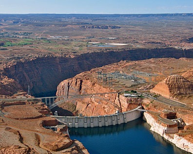
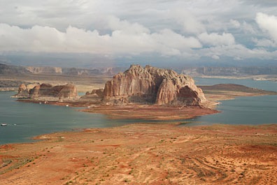 Lake Powell is outrageously beautiful. Its clear, blue water reflects the clear Arizona/Utah sky. Its red rock canyons, buttes, and other formations change throughout the day with the light. Deep, narrow canyons cut into the desert, making mysterious pathways for boaters to explore. When the wind and water is calm, the buttes and canyon walls cast their reflections down on the water. In the rare instances when weather moves in, low clouds add yet another dimension to the scenery.
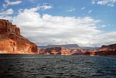 Sure, it’s wonderful by boat — especially by houseboat over 5 to 7 days with a bunch of good friends or family members — but views are limited from the ground and distances take a long time to cover. Let’s face it: the lake’s surface area is 266 square miles (at full pool) and it stretches 186 miles up the Colorado and San Juan Rivers. You could explore the lake by boat for a year and not get a chance to visit each of its 90 water-filled side canyons.
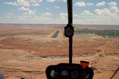 Most people fly into Page, since it’s the only airport near a town. If you come in from the northwest and land on Runway 15, as we are in this photo — well, we’re actually lined up for landing on the taxiway — you’ll make your descent right over the lake, west of Antelope Marina. (The town is all that green stuff to the right.) Taking off on Runway 33 has you shooting out over the edge of the mesa and lake. Pretty dramatic stuff. I have a lot of fun with it since I don’t really “climb out” after takeoff. The airport is at 4316 feet and the lake is currently at 3629 feet, so there’s no reason to gain altitude if I’m just cruising the lake.
 I have a lot more to say about this day trip, but I can’t stop to write about it now. I’m terribly behind on a book project — partially because I took yesterday off — and I need to get the darn book done already.
 Bob, who recently sent a photo of himself holding up the