
Page, the Windy City — and More
Day One: Rushing to Russians
Day Two: Page, the windy city — and more (this article)
Day Three: Lots of flying
Day Four: Night flight on the Rez, rain, rest
Day Five: Rest, a great ferry flight, and a tall ship in the desert
Day Six: One last photo flight and the long flight home
I slept like shit. I don’t know why. The bed was very comfortable and the room temperature was cosy without being hot. The place was even pretty quiet.
I was at the airport by 5:30 AM. My first flight was scheduled for 6:10 AM and I had to get the doors off and do my preflight. I borrowed the FBO’s cart to shuttle myself out there and bring the doors back. The pilots for American, which is also the FBO I used, were doing their preflight stuff. One of them commented about me starting work so early. I didn’t mention that less than two weeks before, I’d been airborne with clients 30 minutes before sunrise.
More Wind
I should mention here that the forecast called for strong winds. When I got to the airport, the wind was calm. I figured that if I could knock off my two morning flights quickly, we might be able to finish before the wind kicked in.
Wrong!
Although we were halfway to the confluence by the time the sun came over the top of a cloud layer to the east, it was already bumpy out near Navajo Mountain. At one point, I had a 30-knot tailwind. We bumped our way past the mountain and spent some quality time at the confluence before bumping our way back. We did Horseshoe Bend and the Dam before landing at the airport.
I warned my next group that I wasn’t going very far up lake. Fortunately, there was a map in the terminal and someone who could translate for me, so they knew what to expect. But by that time, it was getting windy, even at Page. I hit sinkhole at 8000 feet flying circles over Horseshoe Bend that got one of my passengers to scream. I hate when that happens.
By the time I landed, the wind was 14 gusting to 28. I don’t mind wind half as much as gusts. It’s the gust spread that’ll get you every time.
I was done flying before 10:30 AM. I went back to the hotel to check out. I ran into Mike in the lobby. He’d planned on sending someone with me to Monument Valley. But I told him I wasn’t sure if I could make it. That had him bothered. He was scheduled for the afternoon flight there. I told him that if it was too windy to fly out that night, I’d start before dawn and get there in time for the morning flight. Then we parted ways. He had a long drive in front of him. I wasn’t looking forward to the flight ahead of me.
Lower Antelope Canyon
With some time to kill while I waited for the wind to die down, I went to Lower Antelope Canyon. Although I’ve been to Antelope Canyon many times, this was the first time I’d been to the less popular, lower part. It was easy to understand why it was less popular — it required climbing. On ladders.
 Ah, but first you had to pass the entrance exam. I mean that quite literally. You had to step down into the canyon, which appeared as a narrow slot (see photo). I’m not huge but I admit that I had to twist my body a bit to fit into the opening of the canyon. A really fat person never would have made it, which explains why there really weren’t any really fat people in there.
From the mouth of the canyon, it was a few steps down into a world of swirling sandstone chambers. I’d pass through a narrow slot or twisting path that would suddenly open up to a wide area where the light came in, casting a golden glow on the rock surfaces. Then more twists and turns and squeezes with a few ladders and steps thrown in to keep out the out-of-shape riff-raff. The canyon went on for at least a half mile, always descending, with each twist and turn bringing more of the same. I counted two arches carved through the rock, but there may have been more — I missed the first one on my way in.
 There was fine sand under foot and blowing sand drifting down into the canyon from above. Soon, there was sand in my hair and clothes and camera lens. It was a fine red sand that gathered in small dunes and drifts outside the canyon. Inside, it fell like rain from the sky. (One of the first things I did when I got to my hotel room that night was to take a hot shower and get all that sand off me.)
 I took lots of photos. For some reason, I thought the light would be better in Lower Antelope Canyon than the Upper Antelope Canyon, so I’d left my tripod in the car. Very dumb. I really could have used it in there. So I had to play with the camera, using Program mode for some shots and setting other shots to a minimum shutter speed of 1/30th of a second. About 1/2 of the shots are usable and about 1/2 of those aren’t bad at all.
There were quite a few people in there, but they were spread out, so there were plenty of opportunities to just sit and look around, undisturbed, or frame that perfect photo. Unlike Upper Antelope Canyon, visitors get a full 4 hours in the canyon, which is plenty of time to explore and enjoy. (In the upper canyon, you only get about an hour.)
At this point, I think I like Lower Antelope Canyon better than Upper Antelope Canyon. But I need another visit to be sure.
Lunch and Waiting
I hit the Chinese restaurant in the Basha’s shopping center for lunch. Nothing like a Chinese buffet to remind you how much crap the average person eats. But it was quick and easy and cheap. And I really am starved for Asian food.
The car had to go back to the airport or I’d have to pay for another day. So I went back to the airport and turned it in. And then spent the next few hours hanging around with the tour pilots who worked for the FBO there. They flew Cessna 172s and 206s up and down the lake all day. But that day, they were sitting in the pilot lounge, waiting for the wind to die down.
The pilot lounge overlooked the ramp. The FBO’s planes were out there, tied down, facing the wind. If they hadn’t been tied down, they would have been airborne. The wind was gusting into the 30s and someone had even heard the automated weather observation system claim a gust of 43. Sheesh. That made a gust spread of over 20 mph.
I’d tied my helicopter’s blades down to prevent them from flopping around and damaging either the tailcone, blades, or droop stops. One of the pilots wanted to know if it was tied down to the ramp. I guess he thought it might take off like a plane in heavy wind. I told him it was full of fuel so it weighted about 1800 pounds. It wasn’t likely to blow around the ramp.
The pilots traded flying stories. A few of us were up in the “tower” room in the corner of the building when a Cessna 172 tried to land on runway 25. He was pointing right into the wind, but he seemed to have trouble descending. He floated over the runway, then said he was going around. I don’t know where he went around to because he didn’t come back. Kind of weird when you realize that there are only two or three other airports within 50 miles. Where did he go?
Westwind, which flies Cessna Caravans, was picking up the business that American was turning down. Caravans are considerably larger. A group of 17 French people came in, wanting to fly. Westwind warned them that the flights would be very bumpy and uncomfortable. 10 people decided to fly anyway. They split the group into two planes. One of the pilots, as he was leaving, said to us, “Well, it was nice knowing you all.”
Of course, it turned out okay. Although they had to take off with a stiff crosswind on runway 33, they were able to land on runway 25, pointed right into the wind. One of the planes looked as if it were hovering out there before landing.
Decision Time Comes, I Go
Meanwhile, time continued to move on. I’d already called Goulding’s Lodge, where my paid-for room awaited me. Sunset was at 7:08 PM Navajo Time. (The Navajo reservation has daylight savings time; the rest of Arizona does not. That put them an hour ahead of Page.) If I flew, I wanted to be on the ground before sunset. The strip at Goulding’s is not lighted and there isn’t much between Page and Monument Valley on the direct route — or on an indirect route, for that matter. Goulding’s was 60 nautical miles away by air. That was a little over 30 minutes of flight time.
Of course, the wind was howling from the west, making a good tailwind.
If I didn’t go to Monument Valley, I’d not only have to get a room in Page on a Saturday night but I’d have to get to the room and then get back to the airport about an hour before dawn for departure. And I’d have to fly a route I’d never flown before in the predawn light. None of that sounded good to me.
What did sound good was checking into Goulding’s and getting a good night’s sleep.
If I flew out, I’d have to leave by 5 PM. I made my decision at 4:30.
Ah, Tailwinds
At 4:45, I was sitting in my helicopter on the ground, pointed into the wind. My airspeed indicator needle moved from 0 to over 20 knots. While I was parked.
The helicopter shook in the gusts.
One of the dangers of starting an R44 in gusty conditions is the remote possibility of a gust pushing up the front blade while the blades are just starting to spin up. At low RPM, there’s no centrifugal force on the blades to keep them up or out. The front blade goes up, the back blade comes down — and strikes the tailcone. Rare but possible. This is what I was thinking about as the blades started spinning up.
Of course, I didn’t have any problem. (Sometimes I really think I worry far too much.)
While the engine warmed up, I programmed the GPS using a user waypoint I’d created for Goulding’s on a previous flight. Being a private strip, it isn’t in the Garmin database.
A trio of Westwind Caravans were just returning from an exciting uplake flight when I took off.
 I took off right over the ramp and hangars. I had plenty of lift with that headwind and light weight. Things were tricky for the first minute or two, but once I had a good climb and forward airspeed going, I was able to bank gently to the left. The wind pushed me sideways over town. I passed the Navajo Power Plant and headed east.
In no time at all, I had a 143 knot ground speed going. Not bad when I was indicating only about 110 knots airspeed.
My route would take me south of Navajo Mountain rather than uplake. The terrain was a mix of canyons and plateaus. I passed a few scattered ranches. On the southern slope of Navajo Mountains was an airstrip I’d seen on the chart and a few trailer homes with a well maintained dirt road. Otherwise, there wasn’t much in the way of civilization for 60 miles.
I hit turbulence each time I passed a butte or ridge. The wind tossed me around as if to say, “You’re nothing to Mother Nature, and don’t you forget it.” I reduced power each time I hit a nasty spot, then came back up to speed when it smoothed out. I wanted to be on the ground as soon as possible.
I approached Gouldings from the southwest, around the mesa behind it. The air seemed smoother as I followed the runway in. I was very surprised to see two brand new helipads. I moved over to one of them, let Mother Nature toss me around a little bit more, then set down, pointed into the wind.
More Surprises
My second surprise at Gouldings was that my cell phone worked. It turns out, they’d gotten a new cell tower. Although I couldn’t access the Internet — what do I want, everything? — my phone had a good strong signal. I used it to call home and let my husband know I’d arrived safely and to call Goulding’s and get a shuttle to the office from the landing strip.
The next surprise waited for me in the office: my client, Mike. He’d arrived only minutes before. He was shocked that I’d attempted the flight. He was also glad to see me. We’d fly the next day on schedule.
I checked into my room and Mike drove me back down to the airstrip. That’s where my room was: in the hangar adjacent to the landing strip. It’s a pretty big room with two double beds, a table and two chairs, a sofa, and a kitchen area with a stove, fridge, and sink. It doesn’t face the valley like the rest of the rooms at the lodge, but it’s comfortable and quiet and very private.
And it was all mine for three nights.
The Day Winds Down
I had to stand on one of the chairs I’d taken from my room to put the tie-downs on my blades. Where’s the junk plastic furniture when you need it? This chair was heavy!
After unpacking in my room — I hate living out of a suitcase and will always unpack anywhere I’m staying two or more nights — I walked up to the lodge. It’s probably about a 1/2 mile walk, half of which is up a gentle slope. I was still huffing and puffing at the restaurant at the top. They put me in a window seat and I had a very boring but very hearty dinner.
By the time I was finished, it was dark. Or maybe I should say DARK. You don’t know darkness until you’ve come to a relatively empty spot in the desert at night before the moon has risen. The wind was still blowing pretty good, too. The only light out at the airport was the one beside my door at the hangar. But there was a lot of dark ground to cover between the lodge and that light.
I stopped in the office for a ride down.
[composed in a hangar/hotel room while on a flying gig with ecto]
 We started with a trip around Horseshoe Bend, which is south of the Glen Canyon Dam. It’s a neat spot where the river bends in the shape of a horseshoe. The canyon is deep there and the river is calm, green, and cold, having come from depths of Lake Powell. Lots of people like to see Horseshoe Bend, but I think the Goosenecks of the San Juan near Mexican Hat Utah are far more impressive. And the twists and turns in Lake Powell where the San Juan meets the Colorado are simply magnificent — as this photo, which I’ve used over and over again on this site (with apologies to regular readers) attests.
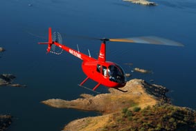 Air-to-Air session. Jon rode with my friend Dave in his Hughes 500c, doors off to get glare-free images of Zero-Mike-Lima. I blogged about that shoot in “
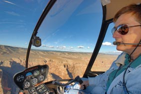 Half-day flight around northern Arizona. Jon’s goal was to photograph some of the places I typically fly over, as well as to get shots of me at the controls with these places in the background. We started in Wickenburg and flew north over Prescott, Mingus Mountain, Jerome, Sycamore Canyon, Howard Mesa, Little Colorado River Gorge, Roden Crater, Grand Falls of the Little Colorado River, Winslow and La Posada, Meteor Crater, and Sedona. Jon got some great shots.
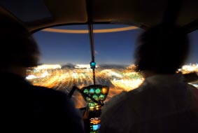 Sunset/Moonlight Dinner Tour. This is one of the tours I offer in the Phoenix area, a flight to a Falcon Field (in Mesa, where we went) or Scottsdale Airport at sunset for dinner followed by a return trip in the moonlight. Jon took some interesting nighttime photos.
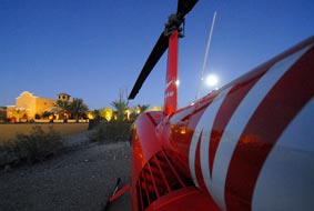 Landing at Norquist home. The Norquists have a unique hilltop home on the northeast side of Wickenburg. I flew for them about a year ago when their Realtor hosted an open house and wanted visiting Realtors to see the town from the air. They graciously allowed us to land there for a photo shoot with the house in the background. We enjoyed some wine — well, Jon and Mike did, anyway; I still had to fly — and great conversation with some really nice people. (BTW, the house is for sale.)
 We flew out of Wickenburg Airport early one morning just after sunrise, when the air was still and cool. Mike flew as a passenger in the Cub with my old digital camera. We flew several passes on the east side of Vulture Peak. Sometimes the Cub lead, sometimes I lead. The best photo of the bunch, which you see here, was with me flying wing at the Cub’s 4 o’clock position.
 The flight wasn’t as structured as the first flight, but it turned out okay. We got some good photos of Tristan around Vulture Peak. I trusted Tristan not to do anything crazy, but there was a certain level of stress as we flew around. I felt a constant need to see where he was because I wasn’t convinced that he understood the whole wing follows lead thing.
 Part of the problem was that Jim sits on the left side in his helicopter and I sit on the right. So when he was flying on my left side, he was mostly in my blind spot and he had difficulty seeing me. And since I thought he’d be watching me, I wasn’t watching him. Until I happened to glance over and see him a little too close for comfort on my left, right after Mike snapped this photo. To say this wigged me out is an understatement.
 We took off from Wickenburg and did a slow orbit around Vulture Peak with me in the lead. Jon sat behind Dave on the left side of the helicopter, dangling his feet out the door. They flew at my 5 o’clock position. At one point, Jon asked me to stop and hover on the east side of Vulture Peak while he and Dave moved slowly around me.