I spend much of the day on the road, driving into smoke and spending the night in a crappy place.
Friday was a driving day for me that was a lot longer than it should have been. The only highlights were lunch with friends and a long-postponed trip to Trader Joe’s. Even my campsite that night sucked.
So I’ll keep this short.
The Long Drive
I needed to be in Maple Valley at noon to meet some old friends for lunch. Normally, that would be less than an hour from where I was camped at Buck Creek Camp: Go northwest on 410 to Enumclaw and then north on 169 to Maple Valley. Easy.

Not exactly the most direct route to my destination.
But a fire had route 410 closed at Greenwater and there was apparently no way to get through. So I had to go around to the south before going west, basically circumnavigating Mt. Rainier National Park. That made it a 3-hour drive.
Of course, I didn’t know that when I pulled out of my campsite at 8 AM sharp. I knew the road was closed and that I’d have to go around the long way, but I had no idea how long that long way was. I had no Internet access and couldn’t use Google Maps to calculate drive time. So I thought I’d make a leisurely drive around the park and get there with time to spare.
I realized this wasn’t the case after stopping for fuel at Packwood and using Google Maps to give me a good route with timing. That’s when I discovered, at after 9 AM — I guess I forgot to mention stopping at a bakery and going about 5 miles out of my way in search of a ranger station — that I still had a 2 hour and 16 minute drive ahead of me. If I left at that moment, I could be there by 11:52.
Holy crap.
So I drove. I took a winding road north from Packwood to the National Park Road and continued west on another road and another road through a succession of towns, each getting a little bigger and more traffic-filled than the one before it. For the first time in days, I was stopping at traffic lights and seeing red lines on Google Maps.
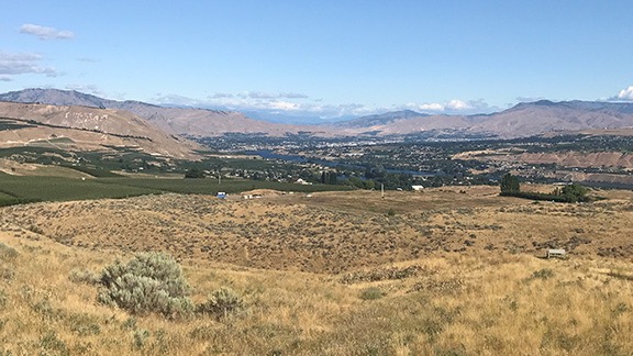
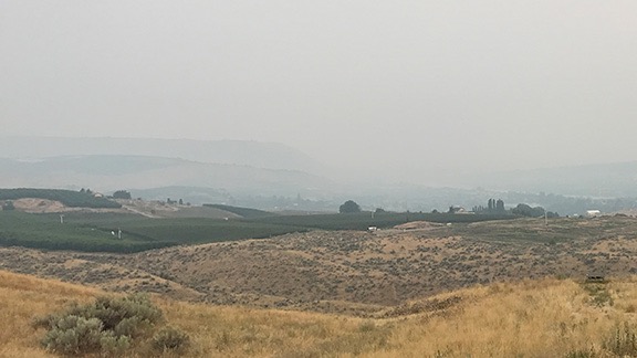
And that’s when I started experiencing the smoke that has blanketed the entire state. It started as a haze and got thicker and thicker until I couldn’t see far ahead. I couldn’t smell it, but by the end of the day I’d have a sore throat.

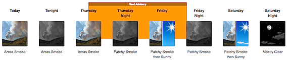
Here’s a picture of the air quality situation on Friday. It hovered around 300 where I was.
Anyway, after a miserable 2+ hours of driving, I finally arrived at my destination: a restaurant in Maple Valley, WA. I parked my rig, took my pups out for a quick pee walk, stowed them in the camper where they had access to food and water, and met my friends for lunch.
A Few Hours in Civilization
The friends I met were Don and Johnie, a couple I’ve known for at least 10 years. Don was a Robinson R44 owner and helped me find hangar space at Deer Valley Airport in Arizona for a season or two before my divorce, when I really tried to make a go of helicopter charter work down there. Don has since sold his helicopter and embraced retirement. I don’t see them often, despite the fact that their summer home is right on the other side of the mountains from me and he has a helipad in his yard. Even stranger is that, like me, they go to Arizona in the winter time and I seldom see them there, either.
It was nice to catch up with them. They’ve been mostly sheltering in place, seeing very few people. This particular restaurant was one of the few they felt comfortable eating at, although they preferred eating on the outdoor patio, which was closed that day due to the smoke. They’re heading back down to Arizona later this month and I’ll make a special effort to meet up with them when I’m in their area.
After lunch, I had Google Maps direct me to the nearest Trader Joe’s. I was in search of figs, which I buy at Trader Joe’s every autumn. They did not disappoint me; I bought three pounds. I also bought some of their olive oil sardines, sugar free chocolate bars, tamales, and the fixings I need to make my granola — mostly unsweetened coconut and flax seeds which are nearly impossible to find at a reasonable price in Wenatchee. By the time I left with my three bags full of food, there was a line to get in; I didn’t realize it, but they were limiting access to the store during the pandemic and I was lucky to be able to get right in.
One more quick stop — this time at a Lowes. I bought a pair of leather gloves and eye protection that I’d need for the blacksmithing course I was starting the next day.
The Crappy Campsite
By that time, it was after 3 PM. I needed a place to park for the night and I didn’t see any decent options between there and my morning destination in Eatonville. I took a route that kept me as close to the national forest as possible, hoping for a forest road I could slip down and park along. But no joy.
In the end, I wound up parking in a mostly empty lot in the town of Eatonville. I spoke to the guys at the used car place across the street and they assured me that the owner of the lot didn’t care who parked there and that semis parked there all the time. I did notice a police car cruising through slowly to check me out, but no one bothered me.

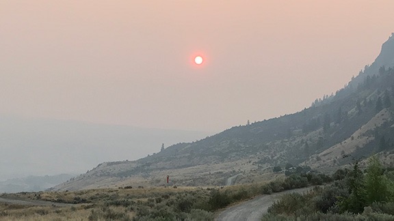
Here’s a view out my window in my Eatonville “camp.” That tiny orange dot just under the wires is the sun.
I took the girls for a walk to a nearby restaurant called Shaken, which had outdoor dining. I figured I’d get a drink and a snack. I thought the place might be nice but it turned out to be kind of redneck. They played country music and none of the servers wore their masks properly. I ordered a drink and food; the drink came quickly and was okay but the food never came. I flagged down the waitress and told her I’d take it to go. She came back a moment later to ask me what I’d ordered. They never made it; I think she forgot to put the order in. I got the check for the drink, paid it, and left. Against my better judgement, I did give her a tip. She had, after all, gotten water for my pups.
I had a terrible night’s sleep. I heard cars go by all night and it didn’t quiet down until after midnight. Some people walked by at 2:30 AM, talking loud enough to wake the girls and get them growling.
I was out of bed by 4 AM. I spent some time working on blog posts and drinking coffee. The girls woke up when it got light out and I took them for a walk. There was a coffee place across the street and I got a breakfast sandwich from them. Pre-made, microwaved. Edible but barely.
By 8 AM, I decided to move on.