FAR 107 Explained

I wrote a book last week and it’s available now.

Way back in 2012, I self-published three books. The first was the same kind of computer how-to book I’d been writing since 1991. It was about iBooks Author software and was the first book out about it. It sold about 3,000 copies and continues to sell to this day. The other two were less successful. One, about sorting data in Excel, sold a few hundred copies. The other, about making movies, sold about 500 copies. All of them were available in multiple formats, including print.

I was on track to release a book a month when the idiot I was married to decided he needed a mommy more than a wife and found one online. My life got thrown up into the air. Soon I was busy with a divorce and moving and building new home in another state. My goal of publishing a series of short books got put on the back burner. And then my flying business really took off and I didn’t see a real need to revisit that plan.

Until the other day.

I got a call from a local drone enthusiast — that’s what he called himself. He’d seen on Facebook that Flying M Air, my company, had begun doing drone photography. He had some questions about it. I had some time so we chatted on the phone.

During the course of the conversation, he asked me two regulation-related questions that I didn’t know the answer for. And that bothered me. You see, I’d done everything I was supposed to do to get a remote pilot certificate with a small unmanned aircraft system (small UAS) rating. I’d satisfied the FAA’s requirements and had a printout of my temporary certificate sitting on my desk. I should know the answers to his questions, but I didn’t.

So a few days later, when I found myself sitting around the house on a rainy day, I looked up the answers. And then I started a careful re-reading FAR Part 107, which is the FAA regulations for commercial small UAS (AKA drone) flying. And I realized that just like all the other FARs, Part 107 was written in the same government-style “legalese,” with the usual exceptions and cross-references that make them nearly impossible to understand.

And that’s when I realized that some folks might find it helpful to read a translation, in plain English, so they could actually understand the rules.

So I wrote one.

Part 107 Explained
Here’s the book cover. A friend asked how I got the photo. I basically flew my Mavic to face me on my deck early in the morning when the light was good. I’ll get a new shot when the fruit trees are in bloom for the next edition.

FAR Part 107 Explained: A Definitive Guide for Serious Drone Pilots is the result.

I started with the actual text of Part 107 and inserted my translation, in red type, beneath each section or paragraph. Along the way, I provided in-document links to other sections of Part 107 and web links to other FARs and documents that Part 107 refers to. I even included links to helpful web pages for registering a drone, reporting an accident, taking the course I did to satisfy training requirements, and changing your name or address in FAA records.

The resulting document isn’t long — after all, Part 107 is relatively short — but it is complete and works as a stand-alone guide to Part 107.

I generated two formats (so far): Apple iTunes bookstore and Amazon Kindle. I submitted to Apple on Friday and Amazon yesterday. (Guess which one was available first?)

In any case, if you’re interested in flying your small UAS/drone for compensation, I hope you’ll consider investing $6.99 for my book. Right now, it’s available as an ebook only; if there’s a big demand for it, I’ll consider a print version. You can buy it on Amazon.com or buy it from Apple.

And I have to admit that it feels good to be writing books again, even if they’re short ones like this.

The Rules about Flying over Wilderness Areas

My answer to a reader’s question.

ChartA week or two ago, I got an email message from a reader who had read my November 2011 post, “A Few Aerial Views from Today’s Flight.” That post shows off a bunch of photos captured by my helicopter’s “nose cam,” a GoPro Hero2 camera I sometimes use in flight. The photos include views of the Verde and Salt Rivers north and east of Phoenix, including some of the lakes along the rivers. My reader noticed, after consulting some aeronautical charts, that much of the area I’d flown over was designated as wilderness area.

This reader, who asked to remain anonymous and not be quoted verbatim, was wondering about “bending” rules. Although he mentioned the June 2012 wire strike helicopter crash in the Verde River area, he wasn’t interested in the safety aspects of maintaining a high enough altitude to clear obstacles. He was interested in my interpretation of the rule about flying at least 2,000 feet above wilderness areas.

The “Rule”

Before I interpret the rule, it’s a good idea to know exactly what the rule is and where it can be found.

It’s interesting to note that a search for “wilderness” and “2,000 feet” in the Federal Aviation Regulations (FARs) does not provide any guidance related to operations over charted wilderness areas. The FARs are the rules pilots are required to comply with.

A search of the Aeronautics Information Manual (AIM) for “wilderness” results in “Part 7-4-6: Flights Over Charted U.S. Wildlife Refuges, Parks, and Forest Service Areas.” Paragraph b pertains to this topic:

b. Pilots are requested to maintain a minimum altitude of 2,000 feet above the surface of the following: National Parks, Monuments, Seashores, Lakeshores, Recreation Areas and Scenic Riverways administered by the National Park Service, National Wildlife Refuges, Big Game Refuges, Game Ranges and Wildlife Ranges administered by the U.S. Fish and Wildlife Service, and Wilderness and Primitive areas administered by the U.S. Forest Service.

A note adds this:

FAA Advisory Circular AC 91-36, Visual Flight Rules (VFR) Flight Over Noise-Sensitive Areas, defines the surface of a national park area (including parks, forests, primitive areas, wilderness areas, recreational areas, national seashores, national monuments, national lakeshores, and national wildlife refuge and range areas) as: the highest terrain within 2,000 feet laterally of the route of flight, or the upper-most rim of a canyon or valley.

First Glance Interpretation

At first glance, the “rule” seems pretty straightforward: you’re supposed to fly at least 2,000 feet above the ground in any charted wilderness area, etc.

User's Guide ImageCharts, by the way, make it very easy to identify these areas. They’re normally surrounded by a blue line that has dots on the inside of the area. This entry from the Aeronautical Chart User’s Guide shows what to look for. And this chart excerpt from the Phoenix terminal area chart (TAC) illustrates how two areas look on an actual chart: The Hells Canyon Wilderness area (left) and Lake Pleasant Bald Eagle Breeding Area (right):

Wilderness Examples

The Advisory Circular note goes a bit further to explain that the lowest point in the wilderness area that you should consider when setting your altitude is the highest point 2,000 feet from your aircraft in any direction. So if you’re flying over a 1,000 foot deep canyon and the canyon is only 1,500 feet wide, you should be 2,000 feet above the canyon walls — not 2,000 feet over the bottom of the canyon.

It’s important to note that a requirement like this is extremely difficult for helicopter pilots to deal with, primarily because helicopters normally operate 500 to 1,000 feet above the ground. We seldom fly 2,000 feet above anything — that’s nosebleed territory for us. That’s also where small planes might be operating — and we’re trained to stay away from them. So when you ask a helicopter pilot to fly 2,000 feet above the ground, we’re not going to like it.

But Is It A Rule?

But the real question should be, is this really a rule? Something that must be followed? Something that could get you in trouble with the FAA if you ignore it?

I can offer two arguments for why pilots are not required to fly 2,000 feet above charted wilderness areas:

  • The “rule” is not included in the FARs, which are the regulations governing flight in the U.S. Instead, it’s described in the AIM, which is informational in nature.
  • The language of the “rule” says that “Pilots are requested to maintain a minimum altitude of 2,000 feet above the surface…” Surely you can’t confuse a “request” with a “requirement.”

Before I go any further, I want to point out paragraph c of the same AIM part (7-4-6):

Federal statues prohibit certain types of flight activity and/or provide altitude restrictions over designated U.S. Wildlife Refuges, Parks, and Forest Service Areas. These designated areas, for example: Boundary Waters Canoe Wilderness Areas, Minnesota; Haleakala National Park, Hawaii; Yosemite National Park, California; and Grand Canyon National Park, Arizona, are charted on Sectional Charts.

Note the use of the word “prohibit” in this paragraph. With a little bit of effort, you can find the rules for these areas in the FARs or Special Federal Aviation Regulations (SFARs). For example, FAR 93 Subpart U and SFAR 50-2 govern special regulations over Grand Canyon National Park. In the case of Yosemite the rule is printed right on the chart:

Yosemite on Chart

In case you can’t read it:

Public Law 100-91 prohibits flight of VFR helicopters or fixed-wing aircraft below 2000 feet above the surface of Yosemite National Park. “Surface” refers to the highest terrain within the park within 2000 feet laterally of the route of flight or within the uppermost rim of the Yosemite Valley.

Pretty clear, no?

My point is, don’t get the idea that a pilot can ignore charted wilderness areas. That simply isn’t true. You need to know whether an area has its own special flight regulations before even considering “breaking” the 2,000-foot “rule.”

What’s Right?

Now you know my interpretation. But I didn’t get this on my own. It was pointed out to me by my primary flight instructor years ago. Pilots who take the time to look up and read the “rules” can make their own conclusions.

The reader who queried me about this obviously realized from the photos I shared on my blog post that I must have been flying lower than 2,000 feet above the ground in a charted wilderness area. Denying I did so when there’s photographic evidence to the contrary would be dishonest, insulting to my readers, and a waste of time.

But is it right to fly low over these areas? Because it’s not a regulation in most wilderness areas, it becomes an ethical decision on the part of the pilot.

First, consider why charted wilderness areas exist. The government is protecting these areas, for whatever reason. Usually, it’s because they don’t want aircraft noise to interfere with wildlife — especially wildlife breeding and habitat maintenance. Sometimes its because they want “natural” areas to be kept quiet for visitors trying to enjoy the beauty of nature in peace.

How do you feel about preserving quiet in these areas? Is it important to you? If you were on the ground, how would you feel if a helicopter or plane buzzed by at 500 or 1,000 feet? Would it bother you? How do you think it affects the people on the ground? People camping, fishing, hiking, meditating?

As the person who contacted me pointed out, when he flew in the area, he didn’t see a person for miles. So who would he be bothering?

The one thing I can say with certainty is this: If pilots typically “busted a wilderness area” by flying low through it and enough people on the ground noticed and complained about it, it’s far more likely that the government will respond by establishing a real rule to prevent it. Yes, at one time people were allowed to fly low-level through the Grand Canyon and Yosemite valley. But when enough complaints came in, regulations were written to make such activity illegal.

Would you want to see that happen with all the wilderness areas on the charts?

I know I wouldn’t.

Early Morning Helicopter Flight: Wenatchee, WA to Hillsboro, OR

There are some things you really wish you could share.

The panic started on Friday. That’s when I checked my helicopter’s log books and realized that instead of 14 flight hours until a required 100-hour maintenance, I had under 5 hours. Once that 5 hours expired, if I flew for hire — even for cherry drying flights conducted under FAR Part 91 — I risked the possibility of having my Part 135 certificate put on hold (or worse) and losing insurance coverage for my helicopter due to my failure to follow the manufacturer’s maintenance schedule.

I did not want that to happen.

I started working the phones. First, I asked my mechanic to come up from Phoenix. I got a “maybe,” which really wasn’t good enough. I talked to a number of other operators about using their mechanics but kept running into a problem with the required drug testing program. Finally, I called the folks at Hillsboro Aviation — which happens to be the dealer that sold me my helicopter back in 2005 — and talked to John. He said that if I could get it in to him when they opened at 8 AM on Tuesday morning, there was a chance that they could have it ready by day’s end.

The weather, of course, was of vital importance. I was in Wenatchee for cherry drying season; if there was any possibility of rain, I could not leave. I did have two other pilots on duty to cover my contracts, though, so unless it rained everywhere at once, they could handle it. And fortunately, the forecast had 0% chance of rain for the upcoming week.

I packed a light bag on Monday night: some spare clothes and toiletries (in case an overnight stay was required), dog food and a dish for Penny the Tiny Dog, and my log books. And on Tuesday morning, at 5:30 AM, I preflighted, packed up the helicopter, set up the GoPro Hero 2 “nosecam,” secured Penny in the front passenger seat so she couldn’t get into the controls, started up, and took off.

Foreflight Route
My direct route, on Foreflight.

My goal was to complete the flight as quickly as possible — that meant a direct route across the Cascade Mountains. My flight path would take me over Mission Ridge, across I-90 west of Ellensburg, and into the Cascades south of Mt. Rainier and north of Mt. Adams. Along the way I’d have to climb to just over 7,000 feet, fly over miles of remote wilderness area, and pass right by Mt. St. Helens. The whole flight was 159 nautical miles (183 statute miles) and would take just over 90 minutes.

I’d flown over the Cascades — or tried to — about a dozen times in the past five years. Weather had almost always been an issue. On several occasions, low clouds in the mountain passes at I-90, Route 2, or Route 12 made it impossible to get through. Other times, I had to do some serious scud-running, darting from one clear area to the next to find my way across. Still other times, I was forced to fly above a cloud layer until I found a “hole” in the clouds where I could slip back underneath on the other side of the mountains. I can only remember one time when scattered clouds were high enough to make the flight as pleasant as it should be.

The weird thing about the Cascades is that you can’t see what the cloud cover is like there until you’re airborne and have cleared the mountains south of Wenatchee. The clouds don’t show up on radar or weather reports unless it’s raining. So you might have a perfectly beautiful day in Washington’s Columbia River basin but the Cascade Mountains could be completely socked in with thick clouds. It’s actually like that more often than not — at least in my experience.

So despite the fact that it was a beautiful day, I was a bit concerned about the weather.

Until I passed over Mission Ridge, just south of Wenatchee. I immediately saw Mt. Rainier and Mt. Adams in the distance. Seeing these two mountains — the whole mountains, not just the tops poking up through clouds — was a very good sign.

Penny immediately curled up on her blanket on the front passenger seat and went to sleep. This really surprised me. It was the first time she’d been in a helicopter and she seemed completely unconcerned about it. I guess that was a good sign, too.

And so began one of the most beautiful flights I’d ever had the pleasure of doing in my helicopter.

Mission Ridge
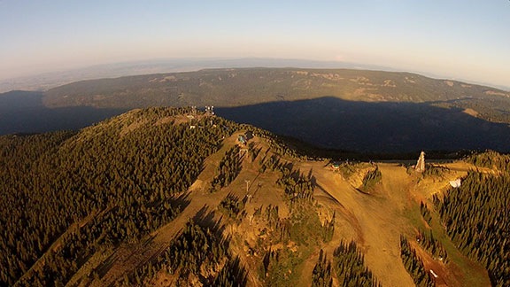
The top of Mission Ridge and beyond.

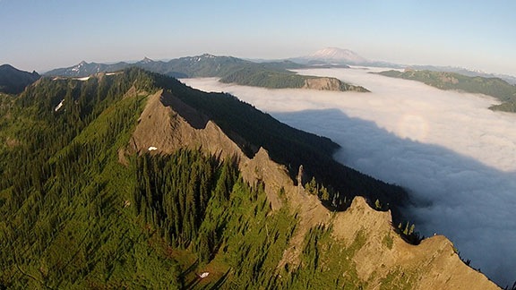
I crossed Mission Ridge, which was glowing almost orange in the first light of day and headed southwest along the straight line my GPS indicated to Hillsboro, OR. I drank in the scenery spread out before me: the windmill-studded valley around Ellensburg, the rolling pine forests cut with stream and river beds, the snowcapped granite ridges. At one point, I had Mt. Rainier off my right shoulder, Mt. Adams and Mt. Hood to my left, and Mt. St. Helens right in front of me. I felt like a tiny speck suspended in the air, the only person in the world able to see just what I was seeing. I felt small but all-seeing at the same time.

When I first caught sight of a fog-filled valley at the base of Mt. Rainier I began to realize that weather might still be an issue. Soon, I was flying from one pine-covered ridge to the next, over what looked like a sea of white foam. No VFR pilot likes to lose sight of the ground and I admit that I flew with some fear. An engine failure would leave me nowhere safe to land — if I tried to land in one of the valleys, I’d likely hit the ground before I saw it through the fog.

But the beauty of what was around me somehow made it okay. I thought to myself, if this is my time to go, what better place and way to end my life? Doing what I love — flying through amazing scenery — what else could anyone ask for? And then all the fear was gone and I was left once again to enjoy my surroundings.

Cascades Ridge
Flying across this ridge was the highlight of my flight.

I also felt more than a bit of sadness. There’s no way I can describe the amazing beauty of the remote wilderness that was around me for more than half of that flight. And yet there I was, enjoying it alone, unable to share it with anyone. Although I think my soon-to-be ex-husband would have enjoyed the flight, he was not with me and never would be again. I felt a surge of loneliness that I’ve never felt before. It ached to experience such an incredible flight alone, unable to share it firsthand with someone else who might appreciate it as much as I did.

I can’t begin to say how glad I am that the GoPro was rigged up and running for the whole flight. At least I have some video to share.

Mountain Lake
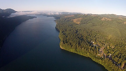
Yale Lake near Cougar, WA, just southeast of Mt. St. Helens.

As I descended down the southeast slope of Mt. St. Helens, leaving the Cascades behind me, I crossed over a small lake with a scattering of clouds at my level. As I glided through them and back into civilization, I felt as if the magical part of the flight was over. Indeed, the rest of the flight was rather routine, passing over rolling hills, farmland, highways, and rivers. A marine layer hung low over the Portland area and I squeezed under it, called the tower at Hillsboro Airport, and landed on the ramp at my destination. It was about 7:30 AM.

Penny at the Beach
Penny at the beach. She seems to like sand almost as much as grass.

The folks at Hillsboro Aviation were great. Although they didn’t finish up that day, the helicopter was ready to go at 9:30 AM the next morning. Penny and I had spent the night in Rockaway Beach, where Penny got to run through the sand and tease the other beach walkers with her antics.

We left Hillsboro at around 11 AM on Wednesday. It was a cloudless day — even the valley fog was gone. But the harsh midday light washed away much of the beauty of the scenery; the GoPro video from the return flight isn’t much to look at. We were back on the ground at our base in Wenatchee Heights before 1 PM, ready for another 100 hours of flight.

Why Are We Still Powering Down All Electronic Devices on Airliners?

There’s no real reason for it.

A Twitter/Google+ friend of mine, Chris, linked to an article on the New York Times website today, “Fliers Still Must Turn Off Devices, but It’s Not Clear Why.” His comment on Google+ pretty much echoed my sentiments:

I do all my book reading on an iPad, and it’s annoying that I can’t read during the beginning and end of a flight, likely for no legitimate reason.

This blog post takes a logical look at the practice and the regulations behind it.

What the FAA Says

In most instances, when an airline flight crew tells you to turn off portable electronic devices — usually on takeoff and landing — they make a reference to FAA regulations. But exactly what are the regulations?

Fortunately, we can read them for ourselves. Indeed, the Times article links to the actual Federal Aviation Regulations (FAR) governing portable electronic devices on aircraft, 121.306. Here it is in its entirety:

121.306 Portable electronic devices.

(a) Except as provided in paragraph (b) of this section, no person may operate, nor may any operator or pilot in command of an aircraft allow the operation of, any portable electronic device on any U.S.-registered civil aircraft operating under this part.

(b) Paragraph (a) of this section does not apply to—

(1) Portable voice recorders;

(2) Hearing aids;

(3) Heart pacemakers;

(4) Electric shavers; or

(5) Any other portable electronic device that the part 119 certificate holder has determined will not cause interference with the navigation or communication system of the aircraft on which it is to be used.

(c) The determination required by paragraph (b)(5) of this section shall be made by that part 119 certificate holder operating the particular device to be used.

So what this is saying is that you can’t operate any portable electronic device that the aircraft operator — the airline, in this case — says you can’t. (Read carefully; a is the rule and b is the loophole.) You can, however, always operate portable voice recorders, hearing aids, heart pacemakers (good thing!), and electric shavers (?).

So is the FAA saying you can’t operate an iPad (or any other electronic device) on a flight? No. It’s the airline that says you can’t.

Interference with Navigation or Communication Systems

In reading this carefully, you might assume that the airline has determined that devices such as an iPad may cause interference with navigation or communication systems. After all, that’s the only reason the FAA offers them the authority to require these devices to be powered down.

But as the Times piece points out, a 2006 study by the Radio Technical Commission for Aeronautics found no evidence that these devices can or can’t interfere. Sounds to me like someone was avoiding responsibility for making a decision.

In the meantime, many portable electronic devices, including iPads, Kindles, and smart phones have “airplane mode” settings that prevent them from sending or receiving radio signals. If this is truly the case, it should be impossible for these devices to interfere with navigation or communication systems when in airplane mode. And if all you want to do with your device is read a downloaded book or play with an app that doesn’t require Internet access, there should be no reason why you couldn’t do so.

And can someone really make the argument that an electronic device in airplane mode emits more radio interference than a pacemaker or electric shaver?

And what about the airlines that now offer wi-fi connectivity during the flight? You can’t have your device in airplane mode to take advantage of that service. Surely that says something about the possibility of radio interference: there is none. Evidently, if you’re paying the airline to use their wi-fi, it’s okay.

What’s So Special about Takeoff and Landing?

Of course, since you are allowed to use these devices during the cruise portion of the flight, that begs the question: What’s so special about takeoff and landing?

As a pilot, I can assure you that the pilot’s workload is heavier during the takeoff and landing portions of the flight. There’s more precise flying involved as well as more communication with air traffic control (ATC) and a greater need to watch out for and avoid other aircraft.

But in an airliner, the pilots are locked in the cockpit up front, with very little possibility of distractions from the plane full of seat-belted passengers behind them — even if some of them are busy reading the latest suspense thriller or playing an intense game of Angry Birds.

Are the aircraft’s electronics working harder? I don’t think so.

Are they more susceptible to interference? I can’t see how they could be.

So unless I’m wrong on any of these points, I can’t see why the airlines claim that, for safety reasons, these devices need to be powered off during takeoff and landing.

It’s a Control Issue

I have my own theory on why airlines force you to power down your devices during takeoff and landing: They don’t want their flight attendants competing with electronic devices for your attention.

By telling you to stow all this stuff, there’s less of a chance of you missing an important announcement or instruction. Theoretically, if the aircraft encountered a problem and they needed to instruct passengers on what they should do, they might find it easier to get and keep your attention if you weren’t reading an ebook or listening to your iPod or playing Angry Birds. Theoretically. But there are two arguments against this, too:

  • You can get just as absorbed in a printed book (or maybe even that damn SkyMall catalog) as you could in an ebook.
  • If something were amiss, the actual flight/landing conditions and/or other screaming/praying/seatback-jumping passengers would likely get your attention.

But let’s face it: airlines want to boss you around. They want to make sure you follow their rules. So they play the “safety” card. They tell you their policies are for your safety. And they they throw around phrases like “FAA Regulations” to make it all seem like they’re just following someone else’s rules. But as we’ve seen, they have the authority to make the rule, so it all comes back to them.

And that’s the way they like it.

How Cell Phones Fit Into This Discussion

Cell phone use is a completely different issue. In the U.S., it isn’t the FAA that prohibits cell phone use on airborne aircraft — it’s the FCC. You can find the complete rule on that in FCC regulation 22.925, which states (in part):

22.925   Prohibition on airborne operation of cellular telephones.

Cellular telephones installed in or carried aboard airplanes, balloons or any other type of aircraft must not be operated while such aircraft are airborne (not touching the ground). When any aircraft leaves the ground, all cellular telephones on board that aircraft must be turned off.

There are reasons for this, but an analysis of whether or not they’re valid is beyond the scope of this discussion.

I just want to be able to read books on my iPad from the moment I settle into my airliner seat to the moment I leave it.

Getting a Part 135 Certificate

Don’t expect free help from me.

Last night, I received yet another e-mail from a helicopter operator with questions about getting a Part 135 certificate. I thought that it was about time for me to explain why people who e-mail me for free help about this won’t get it.

But first, a bit of an explanation of what a Part 135 Certificate is.

What Is a Part 135 Certificate?

A Part 135 certificate is literally a piece of paper issued by the FAA that permits a commercial aircraft operator to perform air-taxi operations. The phrase air-taxi refers to the mission of picking up a passenger at Point A and transport him to Point B. A Part 135 Certificate also permits an operator to conduct aerial tours beyond the 25 statute mile limitation set by Part 91 or the relatively new Part 136. Part 135 gets its name from the Federal Aviation Regulations (FARs) Part 135, but a Part 135 operator must also comply with all other applicable FARs, including Parts 61, 91, and 119.

Zero Mike Lima at Monument Valley

Zero-Mike-Lima at Monument Valley during one of my multi-day excursions.

A Part 135 certificate is worth more than its weight in gold for an operator that has one and can use it properly. For example, if I didn’t have one, I’d be limiting my operations to short tours within 25 miles of my starting point and aerial photo/survey flights. With a Part 135, however, I can also take my tours as far as I like, transport passengers between two points, and even offer day trips and multi-day excursions. In the highly competitive area I live in — Arizona is just swarming with helicopter operators — a Part 135 Certificate gives me the competitive edge I need to stay in business. (With less local competition, I might even become profitable. Wouldn’t that be special?)

There are three types of Part 135 certificates: Single Pilot, Single Pilot in Command, and Basic. I have a single Pilot Part 135 certificate. That means that under my company’s certificate, only one pilot is allowed to fly the aircraft under Part 135: me. (Hint to jobseekers: that’s one reason why I don’t ever hire other pilots.) A Single Pilot in Command certificate is similar, but is used mostly in organizations with aircraft that require more than one pilot; just one of those pilots is allowed to fly as pilot in command, but any other pilot can be second in command. The Basic Part 135 certificate — and I may have its name wrong — allows multiple pilots to act as pilot in command on multiple aircraft. The Grand Canyon tour operator I worked for had a Basic Part 135.

At a recent meeting at my local Flight Standards District Office (FSDO; pronounced fizz-doe), I learned that there are only 4,800 Part 135 certificates in the entire country. If you take a moment to consider what percentage of those could possibly be helicopter operators, you’ll realize that I’m part of a very small club.

The penalty for conducting a Part 135 operation without a Part 135 certificate? Well, I know of at least one pilot who had his license permanently suspended. Ouch. When you consider the amount of time and money a commercial pilot — especially a helicopter pilot — might have invested in a career, that’s a very costly penalty.

Airline operations, by the way, are Part 121, which has tighter regulations.

How to Get a Part 135 Certificate

You work with your local FSDO to get a Part 135 Certificate. It requires multiple meetings at the FSDO to work your way through a flow chart of activities. Although I’ve heard of people getting their Single Pilot Part 135 as quickly as three months — it took me four months — it takes other people years. In fact, more than a few operators have gone out of business while working through the process.

Want Help Writing a Statement of Compliance?

When I wrote this blog post back in 2010, I was firmly against helping operators create their Statement of Compliance. At time time, I was based in Arizona with a lot of competition making it damn near impossible to turn a profit. Things are different now. It’s 2017 and I’m comfortably settled in Washington State with a small market but little competition for Part 135 work. In addition, I have found more lucrative sources of flying revenue that don’t require a Part 135 certificate at all. Add to that the FAA’s recent requirement for all Part 135 helicopter operators to have a radio altimeter and the cost to obtain that and I’m a bit softer about helping others — for a fee. Let’s just say that the FAA has motivated me to sell my experience and possibly increase its workload.

So here’s the deal. If you’re interested in getting help writing a Statement of Compliance for a Part 135 certificate, use the form on the Contact page of this site to get in touch with me. Tell me a little about your business and the aircraft you fly, the kind of Part 135 certificate you’re seeking, and where you are in the process with your FSDO. If I think I can help you, I’ll let you know what kind of compensation I need to write a Statement of Compliance for you.

Keep in mind that although this will make the process easier, it’s still time-consuming and you’ll still have a lot of work to do on your own.

There’s a lot of paperwork. The biggest challenge to most people is the creation of a Statement of Compliance. That’s where you list all the applicable FARs and state exactly how you will comply. My Statement of Compliance, written in 2005, was 54 pages long. It wasn’t difficult for me to create because, after all, I am a writer. But I’d say that 90% of the people who try to get their Part 135 certificate stumble on this component, which occurs about halfway through that flow chart.

You’ll also need to get on a drug testing program, create a training manual for carrying (or not carrying) HazMat, and obtain a secure location for basing your aircraft. You’ll need to create forms for pilots to log time flown, aircraft flight time, and squawks. You’ll need to have perfect maintenance records. If you’re going for a Basic Part 135, you’ll need all kinds of other manuals and documents, as well as staff in predetermined positions, such as Director of Operations, Director of Maintenance, etc.

The FAA did not make the process easy. If it were easy, everyone would have a Part 135. Instead, they made it a challenge.

I am extremely fortunate to be working with an excellent FSDO full of people who are reasonable and helpful. Yes, I’m required to jump through the same hoops as everyone else, but my contacts at the local FSDO help me make those jumps. In turn, I comply with their requests promptly, without question. After all, their mission is to keep me safe. Why wouldn’t I want to be safe?

Why I’d Rather Not Help You Get Your Part 135 Certificate

I’ve already given you several hints on why I’d rather not help you get your Part 135 Certificate. Did you read between the lines to get the answer? If not, I’ll spell it out for you.

  • Rise to the challenge. I personally believe that the FAA makes it challenging to get a Part 135 Certificate as a test to see if applicants are worthy. Let’s face it: the FSDO folks spell out what you need to do — using a flowchart, for Pete’s sake! If you come into the application process with the right attitude, they’ll help you achieve your goal. But they won’t just give you a certificate for showing up. You have to earn it. By jumping through all the hoops and smiling the whole time, you’ll prove that you have the right stuff to be a safe and cooperative aircraft operator. If I — or anyone else — help you get your certificate, you won’t prove anything other than that you can’t do it alone.
  • Membership has its privileges. That old American Express slogan can easily be applied to the 4,800-member club of Part 135 certificate holders. We can do things that Part 91 operators can’t. This gives us far more flexibility in our operations. I can’t tell you what a joy it was to finally be able to say yes to a client request for an air-taxi flight. Saying yes means more business, more revenue.

I get e-mails and calls at least twice a month from helicopter operators hoping I’ll help them get their Part 135 certificate or make their business grow. Apparently, it isn’t enough for me to write about my own experiences here so they can use them as learning tools. Instead, they want me to take them by the hand and walk them through the process.

Why should I? What’s in it for me?

I did the hard work I needed to do to get my certificate and build my business. Isn’t it in my best interest to have other operators jump through the same hoops I did and prove they’re worthy of getting a Part 135 certificate? Wouldn’t I rather be sharing the skies with pilots who passed muster with the FAA? Wouldn’t I rather refer overflow business to an operator I know has the ability to do his own homework?

You want a Part 135 certificate? Take my advice: Call your local FSDO and set up a meeting to get started. Then put a smile on your face, roll up your sleeves, and get to work.