Aerial Photography: Helicopter vs. Drone

Picking the right tool for the job.

I’ve been thinking a lot lately about aerial photography work with helicopters and drones and thought I’d take a few moments to share my thoughts and conclusions. If you think one or the other is the perfect aerial photography platform, think again and read on.

My Helicopter Aerial Photo Experience

I’m a commercial helicopter pilot and have been one for about 17 years now. Of the modest 3,600 or so hours I’ve spent flying, a lot of it has been on aerial photography missions:

    Airplane over Horseshoe BendOne of my favorite clients, Mike Reyfman, shot this photo of Horseshoe Bend near Lake Powell from about 3000 feet up. Note the tour plane, which was probably flying about 1,000 feet over the “shoe.”

  • Fine art photo flights over Horseshoe Bend, Lake Powell, Monument Valley, Canyonlands National Park, and the Four Corners area near Shiprock, New Mexico. (I’ve probably spent more hours with photographers over Lake Powell, mostly from 2006 to 2011, than any other commercial helicopter pilot. At one point, I could identify every point along the lake from an aerial photo.)
  • High speed desert racing photo flights at the Parker 425 in Parker, AZ.
  • High speed boat racing photo flights at Lake Havasu in Arizona.
  • Bike racing photo flights in the Lake Wenatchee and Leavenworth areas of Washington.
  • Automotive promotional photo flights over proving ground test tracks in Arizona.
  • Architectural and construction photo flights in major cities like Phoenix and Las Vegas as well as remote areas such as Burro Creek in Arizona.
  • Geographical photo flights along the Wenatchee and Columbia Rivers, Lake Chelan, and Stehekin in Washington, Colorado River in Utah, and Salt River in Arizona.
  • Agricultural photo flights in the Quincy, George, and Wenatchee Valley areas of Washington.
  • Wildlife photo flights over the Navajo Reservation and Verde River Valleys in Arizona.
  • Nighttime panoramic photo flights over a crowded football stadium at night in the flight path of Phoenix Sky Harbor airport.
  • 360° panorama photo flights over Lake Powell, Horseshoe Bend, Goosenecks, and Bryce Canyon National Park.
  • Air-to-Air photo shoots with everything from another helicopter to the world’s largest biplane to a 747 outfitted for firefighting.

Each mission had a different purpose, a different focus (pardon the pun). Each required a different kind of flying, from 4,000-foot (AGL) hovers to low-level, high-speed chases in obstacle-rich environments. Some required top speed level flying just to catch a target, others required tight, often difficult maneuvers in a choreographed dance with the target. In each case, my helicopter and I were the tools the photographer used to get the shots he needed. The photographer provided instructions and I positioned us where we needed to be.
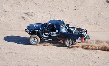
Desert Racing TruckThere’s nothing quite like chasing trucks through the desert with a helicopter.

I love aerial photo work, especially the challenging high-speed work I did over desert race courses. There’s nothing that can give me a buzz more than chasing a trophy truck down a twisty dirt track 80 feet off the ground at 80 miles per hour, so close I can hear his passing horn when he comes up on a competitor.

My Drone Aerial Photo Experience

As I’ve written elsewhere in this blog, I was not happy when I started losing aerial photo work to drones. I fought back for a while but, as technological improvements in both the flying and photo capabilities of drones made amazing results easier to achieve, I eventually got on board. I bought my first drone last winter and got my commercial drone pilot certificate soon afterward. (Yes, if you can’t beat them, join them.)

Here’s some footage from a recent practice flight around my home.

I don’t have nearly as much drone photo experience as I do helicopter photo experience, but I’m learning more every time I go out for a flight. I’ve been doing practice flights around my neighborhood, picking photo targets and flying around them for video fly-by shots and still images. I’ve also been taking my drone out to new locations to practice in target areas I find interesting. This winter, I’ll be using my drone to take photos of campsites out in the desert, as well as my activities on various Arizona lakes and rivers. Practice makes perfect and I’d like to get as good at drone photography as I am flying my helicopter on photo missions.

The Best Tool

I have, however, already come up against the limitations of drone photography, primarily related to speed, altitude, and operating temperature. I figured I’d list a few kinds of photo missions and explain which tool I’d pick and why.

Low-level, Low-Speed Operations

This is pretty much a no-brainer: when you’re operating below 200 feet at speeds of less than 20 miles per hour, a drone is probably going to be the better tool for the job. Yes, a helicopter can fly that low and that slow, but it’s far more likely to cause a disruption.

My best example of this is an aerial photo job I did for a local video production company. Believe it or not, they got the Wenatchee Symphony Orchestra to set up and play at dawn in a local park. The park had lots of tall evergreen trees and the orchestra was set up in a clearing. I had to get the videographer low enough for his closeups. The first time we passed, the helicopter’s downwash blew the sheet music off half the stands. (Oops!) A drone would have been a much better tool for this particular mission — and I actually said so during the flight.

Of course, blowing things around isn’t the only issue a low-flying helicopter can cause. It can also be a distraction to people on the ground. One of the flights I did for the same video company was a flight down Wenatchee Avenue not much higher than the highest buildings in the area. I had to fly sideways since the videographer was shooting out a side door. Although we got the job done, I think a drone could have done it better: it could have flown lower without distracting or disturbing drivers and pedestrians. The fight was short — we got the footage in less than 30 seconds — but a drone could have done the same thing without anyone on the ground even noticing it.

Better Choice: Drone

Low-Level, High Speed Operations

Of course, when you add speed, the drone simply can’t do the job. Consider my work chasing vehicles on land or over water. I’m usually flying at 50 miles per hour or more. (Seriously: on some of the boat shoots, I could not keep up; those things are fast.) I know that my drone’s top speed is about 22 miles per hour; even if a drone could go faster, could it keep up? I doubt it. And what happens when it gets out of range of the operator and his controller?

Better Choice: Helicopter

High Altitude Operations

While too many drone pilots seem to ignore drone altitude restrictions, they do exist and violating them is a good way to get into hot water with the FAA. Of course, trouble is a lot better than the possible alternative: flying into the path of another aircraft and causing a crash. As a helicopter pilot with no minimum altitude, I’m terrified that this might happen to me.

In the U.S., the FAA has established a maximum altitude for drones of 400 feet. Although it may be possible to get a waiver for a specific mission, it can take up to 90 days to get that waiver. How often do you know what you need to shoot 90 days in advance?

Helicopters, on the other hand, don’t have any altitude restrictions — other than those related to the helicopter’s performance capabilities. I’ve done photo flights where I had to hover at 9000 feet above sea level. Even if a drone could get up there, without a waiver it would not be legal.

Better choice: Helicopter

Operations Where Drones Aren’t Allowed

One of the things that really bugs me as a drone pilot is the number of places where drone operations are simply not allowed.

Some of them make sense — after all, do you really want to step up to the rim of the Grand Canyon and see a cluster of drones buzzing around in your view? Or attend an outdoor concert with drones flying back and forth over your head?

Meanwhile, drone restrictions in other places seem to make little or no sense. There are parts of Death Valley, for example, that are so remote they have few (if any) visitors and no wildlife. Why not let someone use a drone to take a few great photos that show off the barren wildness of the terrain?

Whatever.

The point is, there are places you can’t take a drone and, oddly enough, you can still take a helicopter. While flight over the Grand Canyon might be off-limits below 14,500 feet in most places, there are many national parks and other places where drone flights are prohibited but there are no restrictions on helicopter operations.

Let me be clear here: Most national parks are charted and pilots are requested to maintain at least 2,000 feet above the highest terrain in the area. Note the use of the word requested. I’ve written about this before. Although it is legal to fly lower in these areas, it’s not something you should do if you can avoid it. If you become a nuisance, you will be cited and will likely have to fight the FAA to keep your certificate. That’s why a lot of commercial pilots simply say no. Also, if people keep flying low-level through these areas, the FAA will make it illegal.

Until then — well, get those shots with a helicopter because without a waiver, you won’t get them legally with a drone.

Better Choice: Helicopter

As for flying low-level over crowds, that’s just plain stupid. Don’t do it with any aircraft, no matter what size it is.

Operation in Extreme Temperatures

All drones have operating temperature limitations, often due to battery capabilities. My drone, for example, will only operate in temperatures between 32°F and 104°F (0°C to 40°C).

My helicopter, however, doesn’t have any temperature limitations specified in the pilot operating handbook — although many people will argue that since performance charts aren’t available below -20°C or above 40°C, flight at those temperatures isn’t allowed. Newsflash: I’ve seen in-flight OAT temperatures of 112°F (45°C) in my helicopter and it still flew. I’ve also flown it when the outside temperature was about -10°F (-23°C) — the hardest part was getting it started; when it finally warmed up, it flew fine. (Unfortunately, it was a door-off photo flight; I don’t think I’ve ever been so cold in my life.)

The point is, if you need to do the shoot in very hot or very cold conditions, you might have to use a helicopter — or wait until conditions change.

Better choice: Helicopter

Operations Over Long Distances

I once had a photo shoot that included dozens of target locations along a 30-mile stretch of the Wenatchee River, a 50-mile stretch of the Columbia River, and the remote lakeside town of Stehekin on Lake Chelan. In my helicopter, we were able to knock off every location on the list in a total of three hours.

None of the flying was very special. It was relatively low and slow stuff, with some slow circling around points of interest. In fact, all of the shots could have been made with a drone. But that drone would have had to be driven to each location and launched for a flight there. It would have taken many hours to get all the shots and, if light was important — as it was for this shoot — the drone pilot/photographer probably wouldn’t have been able to shoot more than two to four locations each day. Add to that a half-day ferry ride to Stehekin, an overnight stay for the best light, and the half-day return trip and the project could have taken up to a month to complete.

Yeah, it would have been cheaper to do it with a drone. But time is money.

Better choice: Helicopter

Not Quite What I Expected

Part 107 Explained
Want to become a commercial drone pilot? Start by learning all about the FAA’s Part 107. This book will help. Buy the ebook edition on Amazon or from Apple. Or buy the paperback edition on Amazon.

In writing this and thinking about the kinds of aerial photo flying I’ve done, I’m surprised at how few photo missions are better handled by a drone than a helicopter. It seems to me that drone aerial photo flights are pretty much limited to situations where the camera needs to fly low and slow. Anything else would probably exceed the capabilities of the drone or violate the law. That might be where a helicopter can get the job done.

Fortunately for commercial drone pilots, there are plenty of missions that require low and slow flight. So there will never be a shortage of work for them.

But what makes me very happy is the knowledge that drones will never fully replace manned aircraft — including helicopters — for aerial photo missions. After all, that’s the kind of flying I really like to do.

Personal Aerial Photography

A few thoughts from someone who has been doing it for a long time.

I’ve been doing aerial photography since I began flying helicopters, way back in the late 1990s. At first, it was a few digital images shot awkwardly with my left hand while my right hand was busy on the cyclic. Later, I went through a variety of different cameras mounted in and on the helicopter, some set to automatically shoot whatever was in front of them and others with limited control from inside the cockpit. I had a POV.1 camera in 2008, which I replaced with a GoPro Hero in 2010. Since then, I’ve had a variety of GoPros, right up to a GoPro 3+. (Even I get tired of throwing money at new versions of hardware.) I’ve created numerous still and video images from my helicopter, some of which still amaze me.

Great Salt Lake
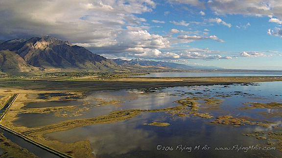
This is one of my very favorite aerial photos: the north end of the Great Salt Lake, shot with a GoPro 3 mounted on the nose of my helicopter as I flew it south to Arizona last autumn. The camera was set to time-lapse mode, shooting one photo every minute. We were probably about 700 feet up here.

But the point of this discussion is this: I’ve been looking at the world from a different point of view for about 20 years now. It’s not the same point of view as an airliner cruising at 29,000 feet and 500 mph. And it’s not the point of view of a private plane cruising at 1,500 feet and 140 mph. It’s the point of view of a helicopter, usually cruising at an average of only 500 feet at 90 miles per hour, with the ability to stop, make sudden turns, or descend for a closer look.

Pilots get used to seeing the world from this different perspective. After a while, it isn’t anything special. We can get a feel for how different things might look from the air: a canyon, a river, a farm, a junkyard. That doesn’t mean it gets boring — it doesn’t. But it does mean that we don’t see anything special about it anymore.

Kind of sad, isn’t it?

That’s one of the reasons I like flying with first time passengers. I get a reminder of what it’s like to see things from a new perspective.

Part 107 Explained
Want to become a commercial drone pilot? Start by learning all about the FAA’s Part 107. This book will help. Buy the ebook edition on Amazon or from Apple. Or buy the paperback edition on Amazon.

But I was reminded again about the novelty of seeing everyday things from above when I watched a documentary on Lynda.com called “Flight Club: Drones and the Dawn of Personal Aerial Imaging.” Listening to the people explain how they felt when they saw these low-level aerial images really helped me understand just how amazing aerial photography is, especially to folks that don’t have a helicopter at their disposal — which, admittedly, is most people.

Folks who know me well know how anti-drone I was when they first started appearing on the scene a few years back. But what convinced me that they were serious photography tools is the quality of the images they produced and the ease at which an operator could get them. I dove into drone photography last winter with the purchase of a Mavic Pro and will be doing a lot more of it in the months to come.

If you are curious about drones for aerial photography, I highly recommend you spend 25 minutes or so watching the documentary I saw last night. I think you’ll enjoy it and learn a lot about why people are so excited about it.

If you do watch, let me know what you think.

The Eclipse Trip Days 5-7: The Palouse, Spokane, and Lake Roosevelt

I finish up the trip in an uneventful way.

Although I tried hard to blog about each day of this trip shortly after it happened, I ran out of steam after my trip to Walla Walla. I think there are two reasons for this:

  • The rest of the trip wasn’t very interesting.
  • I spent a lot of time driving.

So I’ll just sum up here.

Day 5: Walla Walla to Palouse Falls

In the morning, I went down to the motel breakfast room for coffee, eggs, and sausage. They were all horrible. Honestly: I’d rather have a cold and stale Egg McMuffin than just about anything served up at a motel’s “free” breakfast. The eggs and sausage were so bad that even Penny wouldn’t eat them.

Later, after packing up and stowing my things back in the camper, we went for a walk on Main Street. I stopped at an outside cafe for a good cup of coffee. They sold fresh figs by the pound inside so I bought a pound to munch on later in my trip. I love figs so, as you might imagine, they didn’t last long.

I wanted to get some wine tasting in before I left town and to do that I had to wait until 11 AM. That’s when I hit Trust Cellars on 2nd Street. The hostess from the restaurant where I’d had dinner the night before had recommended it. I chatted with her father, the wine maker. I soon began to realize that very few Walla Walla area wineries grew their own grapes. The wine was pretty good, so I bought three bottles.

From there I went to lunch at a “southern comfort food” restaurant on Main Street called Whoopemup Hollow Cafe. I had a gumbo that was good but took half of it to go. I also had a peach cobbler for dessert that was excellent.

Then on to Walla Walla Airport. Yes, the airport. Believe it or not, quite a few of Walla Walla’s wineries have tasting rooms at the airport. It used to be an air force facility and there are lots of barracks and other buildings there dating back to the World War II era. Wineries have set up shop in these buildings. Although most are simply tasting rooms, a few also do production and/or bottling. I visited two tasting rooms next to each other, Buty Winery and Adamant Cellars. Buty had been recommended by the winemaker at Trust. Neither impressed me, but I bought a bottle from each because I always buy wine when I go tasting unless it’s simply undrinkable.

I’d wanted to hit a third winery at the airport but since I was so unimpressed with the first two and had drunk enough before 2 PM, I headed out instead.

My destination was Palouse Falls, where I hoped to spend the night. The drive would take me through much of the Palouse, a sort of mecca for photographers.

The Palouse is an area of Washington State with rolling hills covered with wheat. At a certain time of the year — July and early August, I expect — it’s an amazing place to photograph — well, rolling hills covered with green (July) or golden (August) wheat. Google Palouse Image and see what I mean.

I’ve always wanted to get out there in just the right season, but that season happens to be my cherry drying season when I’m pretty much stuck in the Wenatchee area. So I can’t see it until the wheat has already been harvested and it isn’t nearly as attractive.

The drive was a lot longer than I expected but was pleasant and scenic without the least bit of traffic. Honestly, I think that my road trips have spoiled me because of often travel to places on routes that no one else seems to use. The only time I experience traffic these days is when I’m driving through Wenatchee and have to deal with traffic lights.

Palouse Falls is a 200-foot waterfall on a place along the Palouse River where it cuts through a canyon and drops into a crack in the terrain. The visitor parking area is on a hillside overlooking the falls so most of the photos you see of the place look like aerial shots.

Palouse Falls from the Overlook
I shot this photo of Palouse Falls from the parking area not long after our arrival. The light was flat and never did get interesting during my stay.

Permit me to vent a little about No Fly zones for drones.

First of all, the No Drone rule at Palouse Falls is a Washington State law. It prevents people from launching a drone from within any State Park. Palouse Falls is a State Park.

What it doesn’t prevent is launching a drone from outside a State Park and flying it into that park. You see, the state doesn’t control the airspace. That’s the FAA’s jurisdiction. As I pilot, I know a lot about airspace and where it’s legal to fly. I also wrote a whole book about FAA Part 107, which lays out regulations for commercial drone flight that include regulations for non-commercial drone flight.

So there would be nothing stopping me from launching the drone from outside the park and flying it into the park as long as I didn’t fly over any people, kept it below 400 feet above ground level, and somehow — this is the tricky part — managed to keep it within sight at all times.

But do you want to know what’s really crazy? I could fly my helicopter into the park, which I guarantee would get a lot more notice than a half-pound drone, and maneuver it down into the canyon to get the shot I wanted. Legally. Again, the state does not control airspace and as long as my skids didn’t touch the ground inside the park I wouldn’t be breaking any laws.

Would I do that? What do you think?

It’s just an example of how absurd the rules can be — prohibiting one activity that could be a minor annoyance to a few people while allowing another activity that would definitely be a major annoyance to everyone within the park.

In reality, a better view of the falls would be from a drone hovering below the operator inside the canyon. In fact, it would be a perfect shot. But although I had my Mavic Pro with me, there were enough No Drone signs and other visitors to prevent a launch.

It was a gray day. Beyond the smoke-induced haze were clouds spreading rain in the area. I had a cell signal and could track a few rainstorms on radar. It rained a little on us, but not enough to get wet.

Tired from driving and still hoping to do some nighttime photography there, I paid for a campsite and parked next to it. This was apparently a no-no, as I learned from a ranger in the morning. He didn’t cite me but he did lecture me until I pretended to understand and agree with the absurd rule. Yes, tent campers are allowed to park in the lot and then pitch a tent on the grass and sleep in that. But no, people without tents can’t just park a car or truck in the lot and sleep in their car or truck. The rule had nothing to do with parking but everything to do with where you actually slept. If I had pitched a tent and slept in that, there would have been no problem. Next time, that’s what I’ll do.

Palouse Canyon
I think the view down the river from the falls is far more interesting than the falls themselves. Look at those layers of basalt!

In the meantime, the girl who’d parked near me and slept in her car, slipped away while I was being lectured. I didn’t turn her in. Heck, not everyone can afford camping gear. Why shouldn’t she be allowed to spend the night in a safe place, sheltered by her own vehicle? The rule was absurd and I certainly had no intention of helping them enforce it.

Of course, the sky never did clear up that night so I didn’t get the opportunity to do any night photography.

All in all, I consider my trip to Palouse Falls a disappointing bust.

Day 6: Palouse Falls to Lake Roosevelt via Spokane

My Palouse Falls experience left a bad taste in my mouth that I was eager to wash away. I figured that a trip to Trader Joe’s in Spokane to stock up on a few pantry goods followed up with lunch in my favorite Ethiopian restaurant — okay, so the only Ethiopian restaurant I know — would fix me right up.

But I did make one interesting stop along the way: Steptoe Butte.

Steptoe Butte is a granite outcropping that juts up out of those rolling hills. It’s tall so, as you might expect, they put antennas on it. There’s a road that spirals up to the top and offers unobstructed views in every direction.

View from Steptoe
The view from Steptoe Butte. I think this was north, but it could have been any direction. The view is pretty much the same no matter where you look: lots of rolling wheat fields.

Road to Steptoe Butte
When I say the road spirals, I’m not kidding. Here’s how it looked on Google Maps on the way down.

On the day of my visit, it was still hazy with smoke. It was mid afternoon and the light was flat. In other words, not the best conditions for landscape photography. Of course, camping isn’t allowed up there so anyone with the thought of spending the night after a golden hour evening shoot or before a golden hour morning shoot (or both) would be disappointed. No camping anywhere near there at all. Still, photographers make the long drive out there pretty regularly before dawn or back after sunset to be there at the right time. That wasn’t going to be me, at least not that day.

I came back down and continued on to Spokane. A little over an hour later, I was battling local traffic to maneuver my rig into a Trader Joe’s parking lot (which, fortunately, was part of a strip mall parking lot), shopping for things I can only get at TJ’s (if you like sardines, their sardines in olive oil are the best), and then making my way to Queen of Sheeba Ethiopian Cuisine on the Spokane River (great food).

Then I faced the option of ending my trip by making the 3-1/2 hour drive home or staying on the road one more day and finding an interesting campsite to spend the night. Not really fully decided either way, I found a few potential overnight destinations on the map that were also on the way home. If I found a spot I liked, I’d stop. Otherwise, I’d drive home.

I wound up along Lake Roosevelt, a very large lake on the Columbia River created by the Grand Coulee Dam. I’ve flown over it a few times and it’s the kind of place I’d really like to spend more time exploring, preferably with a boat or even a houseboat.

It was late Thursday afternoon, and the first campground I stopped at, Keller Ferry Campground, was crowded with loud RVers and their loud families. I almost backed into a campsite that was not much more than a glorified parking space in an asphalt lot with a picnic table on the grass nearby. But I knew I’d hate it and I hate paying for things I hate. So I pulled out and continued on my way.

The second campground, Spring Canyon, which was nearly all the way to Grand Coulee, was much more pleasant. Lake Roosevelt is a National Recreation Area and this campground was managed by the park service. The other was managed by a concessionaire and you can really tell the difference. The sites were on a hill with views of the lake. The spots were spread out a bit with lots of shade but little underbrush. I drove around and finally found an open spot that just happened to be designated as handicapped. A sign said that if it was still available after 6 PM, anyone could have it for one night. (Apparently, handicapped campers need to get where they’re going by 6.) It was 6:30. I only needed it for one night. I backed in, checked the level, was satisfied, and shut the engine.

It wasn’t until after I paid the $12 fee in the self-pay station that I regretted my choice. That’s when the white trash family in the site next to me went off the rails. They had three young sons aged 12 and below and one of them — I never could figure out which one — was misbehaving. That got dad yelling and threatening. Then mom joined in. Soon they were both yelling and cursing at each other and the kids. I have never heard a couple throw the F-bomb so loudly in public in front of their own kids and other kids as much as these two did. Fuck this fucking fucked up thing. Well, okay, not exactly that, but close. It reminded me too much of time spent with my ex-brother-in-law, a low-life loser who couldn’t complete a sentence without some form of the word fuck in it. But these people were doing it loudly in a campground full of families.

I wanted it to stop. I looked around for a ranger but didn’t see anyone. I was just starting to wonder if it was worth complaining to the campground host when they finally settled down. I think someone got sent into the tent. Mom settled into a chair to study her phone. Dad disappeared.

You don’t get scenes like this when you camp out in the middle of nowhere. You get the sound of nature — wind, birds, falling water, coyotes, squirrels high in trees chattering at small dogs on the ground — or no sound at all.

Anyway, things were fine after that. I ate reheated leftover Ethiopian food on the back steps of my camper, looking out over a campground that was settling down for the night. Someone nearby — maybe in the camper van? — started playing a flute and it sounded very nice. I took Penny for a walk around the campground and then we climbed up into the sleeping area for bed.

Day 7: Lake Roosevelt to Home

I woke up before dawn, as usual. I had coffee while Penny slept in. I caught up on Twitter and did the word puzzle I try to start each morning with. Each morning I have an Internet connection, anyway. It’s a daily puzzle and I’ve done it faithfully every day for the past 70+ days.

When it got light, I took Penny for a walk down on the beach. I let her loose to run on the sand. She loves the beach.

Dawn at Lake Roosevelt
Dawn at Lake Roosevelt.

It was quiet and very pleasant. I watched the sun rise and saw the first light hit hillsides beyond the dam. I wished I had my boat with me. I thought about boat camping. I had recently bought a new tent that would give me, Penny, and even a companion plenty of space to camp in and was eager to use it along a lake or river.

Back at camp, I made breakfast and ate it on the back steps. Other campers were waking. There was no sign of life from the tents at the loud family’s camp. I wondered if the husband or wife had killed the family during the night.

I did the dishes and went through my morning routine. By that time, the loud family was awake and breaking camp. They sure didn’t look like happy people. I wonder sometimes why people bother going on vacation when they spend so much time fighting with each other and staring at their phones.

Penny and I went out for another walk. Although I’d only planned to walk around the campground, I found a “nature trail” and started up that. It was a dirt path that climbed up a hillside with numbered markers along the way that had likely, at one time, corresponded to points on a self-guided tour. There were a few benches along the way that looked like good places to stop and look out at the lake and contemplate life. I stopped at the one at the top of the hill. There were nice views from up there of the lake and campground. The trail continued and we followed it, not sure where it would lead us. It wound up bringing us back down to the campground, no far from our site.

Lake Roosevelt
A view of Lake Roosevelt from the highest point on the trail.

The loud family was gone. There was an inflated beach ball under my truck. I fished it out and gave it to a family with small kids that was camped nearby. The one that spoke English thanked me and handed it off to two young girls who immediately started playing with it. The rest seemed to speak Russian.

I was already ready to go. So I hopped into the truck, started up, and asked Google to show me the quickest way home.

I did stop at the dump station on the way out to dump the holding tanks. I have a very convenient place to dump at home, right near the door to the garage where the camper lives. But I’d rather dump before going home. Then I can add a gallon of clean water and chemicals to the tank and let it slosh around in a sort of cleaning cycle on the way home. It’s a losing battle to keep the tank sensors clean but I haven’t given up. This is just one strategy in my fight.

Our route home took us down the east side of Banks Lake, over the dam at Coulee City, and then up onto the Waterville Plateau. I made a quick stop to look at a vintage pull trailer in Waterville where I chatted at length with a man who’d stopped to do the same thing. Then we descended down to Orondo. I stopped at Katy Bee’s farmstand-turned-cafe for lunch and an ice cream. From there, it was less than 30 minute to get home.

My first vacation for the season was over.

More about the Wind Machines

A few new videos.

Back in April 2015, I blogged about the wind machines commonly used for frost control in the Wenatchee Valley. Resembling tall fans, different versions of these machines can be found in agricultural areas throughout the west wherever frost — especially early spring frost — is an issue. Around here, they’re often in low areas subject to thermal inversions.

Wind Machine
The wind machines that were running this morning. That’s the Mission Ridge Ski resort in the background. Photo shot with my Mavic Pro.

The machines are fans that generate wind. The blades spin fast — faster than you might think watching the video below — to circulate the air. The fan heads rotate to constantly change the direction of the wind. The net result is that the air is circulated, bringing warm air from above down into the crops.

In the almond orchards of California, they use helicopters to do this. I think it’s because the orchards are so big that they simply can’t install and maintain as many wind machines as they need. The helicopters are likely a lot cheaper in the long run, especially when you have a few years in a row when they’re not needed. I’ve been on frost control contracts for the past five winters now and have yet to turn a rotor blade over an almond tree. (Global climate change?)

This winter was particularly long, setting the tree fruit back two to four weeks. The cherry trees are still blooming around here; last year, the cherries were already beginning to redden in the orchards closest to my home. Nighttime temperatures at my home have been in the low 40s. But in the orchards below me, pockets of colder air form. And this morning, they got cold enough to trigger the temperature-set auto start feature on the wind machines in the closest orchards.

I don’t know exactly when they started. I was up at 4:30, reading before getting out of bed, and I didn’t hear them. But by the time I made my coffee at 5 AM, I could hear them faintly through the walls and windows of my my home. I stepped out on the deck for a better look in the predawn light. The sound was louder and I could see two of the machines to the west spinning. My ears told me that one to the northeast, which I can only see from a handful of spots on my deck, was also spinning.

Here’s the zoomed in video I shot with my phone. When I shut up, you can hear the wind machines.

I did a Periscope — that’s a live Twitter video — of the wind machines. A handful of people tuned in and I answered questions as they came up. I was frustrated that I couldn’t zoom in. I signed off, used the video feature on my phone to capture a short zoomed-in clip, and posted it on Twitter. Then the sun rose and the light got good and I did another Periscope that was mostly to show off how beautiful the area was. The wind machines droned in the background of my voice as I described various things and answered questions.

I went inside, washed some pots from cheesemaking, and listened to the radio. I could hear the wind machines faintly through the walls and windows. I was sort of bummed out that I couldn’t give people a better view.

Part 107 Explained
Want to become a commercial drone pilot? Start by learning all about the FAA’s Part 107. This book will help. Buy the ebook edition on Amazon or from Apple. Or buy the paperback edition on Amazon.

And then I remembered my Mavic Pro.

It took only two or three minutes to set it up. I launched it from my deck, got the video camera going, and sent it to the wind machines, stopping before it got so close that the wind could affect it. The light was beautiful and the image the Mavic sent back to me was clear. I hovered for a while to capture a good clip and then flew around a little, just taking in the view with the camera running. I stopped the video camera, took some stills, and then flew home for some more video of my home and the area around it.

Back inside, I made a fresh cup of coffee and spent a few minutes editing the video and setting it to music. It’s unfortunate that the Mavic doesn’t capture sound, but I understand why: it would be capturing its own buzzing sound, which isn’t pleasant. So music will have to do.

A side note here: I’ve been thinking a lot lately about how much I like living here. I realized — and I think I mentioned in one of those Periscope videos — that I like it here more than anywhere else I’ve lived. I’m not sure if it’s because of the place itself or the fact that I have a home with an amazing view built to exactly meet my needs or because after a stifling relationship that went on a lot longer than it should have I finally have the freedom to do what I want to do with my life and time.

Whatever the reason, I just want to remind readers that we all have just one life and it will eventually end. Don’t waste it stuck in a rut or in a place you’re not happy.

FAR 107 Explained

I wrote a book last week and it’s available now.

Way back in 2012, I self-published three books. The first was the same kind of computer how-to book I’d been writing since 1991. It was about iBooks Author software and was the first book out about it. It sold about 3,000 copies and continues to sell to this day. The other two were less successful. One, about sorting data in Excel, sold a few hundred copies. The other, about making movies, sold about 500 copies. All of them were available in multiple formats, including print.

I was on track to release a book a month when the idiot I was married to decided he needed a mommy more than a wife and found one online. My life got thrown up into the air. Soon I was busy with a divorce and moving and building new home in another state. My goal of publishing a series of short books got put on the back burner. And then my flying business really took off and I didn’t see a real need to revisit that plan.

Until the other day.

I got a call from a local drone enthusiast — that’s what he called himself. He’d seen on Facebook that Flying M Air, my company, had begun doing drone photography. He had some questions about it. I had some time so we chatted on the phone.

During the course of the conversation, he asked me two regulation-related questions that I didn’t know the answer for. And that bothered me. You see, I’d done everything I was supposed to do to get a remote pilot certificate with a small unmanned aircraft system (small UAS) rating. I’d satisfied the FAA’s requirements and had a printout of my temporary certificate sitting on my desk. I should know the answers to his questions, but I didn’t.

So a few days later, when I found myself sitting around the house on a rainy day, I looked up the answers. And then I started a careful re-reading FAR Part 107, which is the FAA regulations for commercial small UAS (AKA drone) flying. And I realized that just like all the other FARs, Part 107 was written in the same government-style “legalese,” with the usual exceptions and cross-references that make them nearly impossible to understand.

And that’s when I realized that some folks might find it helpful to read a translation, in plain English, so they could actually understand the rules.

So I wrote one.

Part 107 Explained
Here’s the book cover. A friend asked how I got the photo. I basically flew my Mavic to face me on my deck early in the morning when the light was good. I’ll get a new shot when the fruit trees are in bloom for the next edition.

FAR Part 107 Explained: A Definitive Guide for Serious Drone Pilots is the result.

I started with the actual text of Part 107 and inserted my translation, in red type, beneath each section or paragraph. Along the way, I provided in-document links to other sections of Part 107 and web links to other FARs and documents that Part 107 refers to. I even included links to helpful web pages for registering a drone, reporting an accident, taking the course I did to satisfy training requirements, and changing your name or address in FAA records.

The resulting document isn’t long — after all, Part 107 is relatively short — but it is complete and works as a stand-alone guide to Part 107.

I generated two formats (so far): Apple iTunes bookstore and Amazon Kindle. I submitted to Apple on Friday and Amazon yesterday. (Guess which one was available first?)

In any case, if you’re interested in flying your small UAS/drone for compensation, I hope you’ll consider investing $6.99 for my book. Right now, it’s available as an ebook only; if there’s a big demand for it, I’ll consider a print version. You can buy it on Amazon.com or buy it from Apple.

And I have to admit that it feels good to be writing books again, even if they’re short ones like this.