Drones and Helicopters

A short, engaging video from the UK CAA for drone pilots.

This morning, one of my Twitter pilot friends in the UK shared a one-minute video from the UK CAA that quickly and effectively told drone pilots to be look and listen for helicopters that might be flying at their altitude. Remember drone pilots are supposed to stay under 400 feet altitude (in both the UK and the US) and helicopters have no minimum altitude (at least not in the US). That means we share that space. Of course, if drones illegally (or with a waiver) fly higher, that’s even more space that we share.

I watched the video. It was excellent. A link in the tweet pointed to the “full version” and I clicked it. It’s only 3 minutes long and has the same basic message but includes some interesting B-roll footage of an EMS helicopter and operations. Something to keep watchers engaged while the message is shared. Here it is:

Again, I know this is a UK CAA production, but it applies in the US, too. And likely many other countries that have drone/UAV regulations.

When I retweeted this with a mention the FAA’s Twitter account, the FAA — to my surprise — immediately responded to a link to their YouTube playlist:

I took a look. What I found didn’t surprise me at all. It was the same dull FAA content I’ve been looking at for the past 20 years. Short slideshows that look like they were produced with PowerPoint 95, narrated with a boring authoritative voice. Screen captures of 30+ minute long webinars featuring a tiny talking head and the same dull slide shows. This is the FAA’s idea of continuing education: producing content that no one wants to watch.

See for yourself. Watch the video I embedded above. Then try to watch a few that the FAA linked to. Do you see the difference? I do.

When I critiqued the FAA on Twitter, they responded with this:

I looked at a few of these videos. Some of them are indeed better. One or two are actually pretty good.

Of course, leave it to the FAA to try to enlist me as a volunteer to help them. They have a lot of nerve. Their often absurd rules cost me money that lines the pockets of other businesses without increasing safety. The requirement for VFR-only aircraft to spend $10K to $20K to install a completely useless radar altimeter is one example. The requirement to have a mechanic remove and reinstall my doors when I need them off is another. But now I’m getting way off topic. And angry.

My point is, the UK CAA put together a short, interesting, and informative video (embedded above). We need more of that and we need the FAA — with or without industry partners — to step up to the plate and provide it.

Snowbirding 2018: Intaglio Hunting by Drone

We apparently found what we were looking for but didn’t know until much later.

Boating Trail Guide Book Cover
This little book was written for folks in kayaks and canoes, but still has good information for a shallow draft boat like my Sea Rayder.

Back in November, when I was still home planning my snowbirding trip, I stumbled upon a PDF booklet titled Colorado River Boating Trail Guide: Blythe to Imperial Dam. My little sport jet boat was already in Arizona with my camper, waiting for my return and I knew I’d be spending part of December and possibly January camping along the river. I needed destinations to explore and this little book had them.

Mohave Wash Entry
Here’s the entry for Mohave Wash. Seems pretty straightforward, no? Just boat down to the jetties.

Fast forward to December. I was camping out with my friend Janet along the Colorado River south of Ehrenberg, AZ and thumbed through a printed copy of the book that I’d brought with me. (It’s only 16 pages.), I found an interesting entry on page 6 for Mohave Wash. It mentioned the Ripley intaglios, which I’d never heard of. At the time, we were camped on one of the many backwaters at about river mile 7.5; Mohave Wash was at river mile 11.5, only four miles away. It seemed like a good destination for a test drive of my newly repaired boat.

(Yes, my boat broke on this trip. Fortunately, the problem occurred before we left the backwaters for a ride on the river and I was able to limp back to camp. Later, I got it to limp back to the boat ramp and onto the trailer for a ride to the boat shop in Blythe, which was probably pretty happy to have the business right before Christmas. It was the forward/reverse cable, but I got the throttle cable replaced, too. The boat was gone for a week and when I got it back in the water, I was very anxious to get it out on the water for testing.)

Janet, Penny, Dually (Janet’s dog), and I headed out on December 26 as soon as the water was high enough to get out of the backwaters. (The water levels varied throughout the day based on the demand for power from Parker Dam 70+ miles upstream and irrigation needs in California. The backwaters and river generally became navigable for my little boat after noon each day and remained that way until after sunset.) The throttle worked more smoothly than ever before. It was a warm, sunny day and it felt good to feel a 30 mph wind in my hair as we sped down the river at my little boat’s top speed. We kept an eye out for shallow water and found some, but the boat’s shallow draft let us glide over it.

After a while, we saw some bluffs off to the left and figured they must be the ones in the description. We began looking for the jetties.

And didn’t find them.

Maybe my idea of a “jetty” differs from the person who wrote that book. My idea of a jetty is a finger of land or rock that juts out perpendicularly (or nearly so) into a body of water. I think of the rock jetties jutting out into the Atlantic Ocean for erosion control. Or the jetties on either side of the entrance to a harbor. There was nothing even remotely resembling that along the river.

Yet here were the bluffs that the intaglios were supposed to be on top off. And we’d gone about four miles. This had to be it.

I pulled off into the shallow water on the Arizona side and we got out. It was a dumb spot; there was nothing to tie off onto. So I moved the boat to a new spot where Janet found a huge rock to tie the boat to. The water made an eddy there, so there wasn’t much chance of the boat leaving without us. We got on shore. Janet brought her fishing pole and I brought my drone.

Of course I did. I had no intention of climbing to the top of bluffs to find something I could only see from the air.

While Janet fished, I launched the drone, using my sweatshirt as a landing pad. I sent it up over the bluffs with the lens pointed straight down and studied the images it sent back to me. I took video (or thought I did), landed, swapped batteries, and took off again. On the second flight, I snapped a few photos. I didn’t see anything resembling an intaglio on screen.

Beached on the Colorado
A drone’s eye view of the “jetty” (?) where we stopped along the river.

I landed the drone again and we packed up to go. The bluffs were large and it seemed that the chances of me finding anything on my two short flights was very slim. I was disappointed, but not too surprised.

We got back into the boat, cast off, and drifted back into the current. I started the engine and we went a mile or two farther down river before turning around and going back to camp. It had been a nice outing, despite my failure to find the intaglios.

Days later, I offloaded the drone images from its MicroSD card to one of the portable hard disks I use to archive my photos. I took a look at what I’d shot. That’s when I realized that I didn’t have the video camera running during that first flight so I had no visual record of it. But the photos I took during the second flight were there and I took a quick look at them.

And got a pleasant surprise.

Although I didn’t see anything on the screen during the flights, the two random photos I took while over the bluffs both revealed intaglio figures.

Ripley Intaglios
I was very surprised to see the intaglios in this image. I wonder what I missed when I thought the video camera was running?

Ripley Intaglios
Here’s a closeup of that part of the image.

Ripley Intaglios
I didn’t notice the figure in this photo until I looked at it in preparation for writing this blog post.

Ripley Intaglios
Here’s a closeup. This is definitely man made. (So are the tire tracks nearby.)

Seeing that I managed to capture intaglios on both of the two images I shot while over the bluffs makes me wonder what else I missed.

Of course, I do have the GPS coordinates, so it would be easy enough to go back and explore some more. I’d probably drive, though; there is a road nearby and the bluffs aren’t that high. Seems like a good destination for next year’s trip to this part of Arizona.

If you’re interested in intaglios, be sure to check out this post: “Snowbirding 2018 Postcards: The Blythe Intaglios.”

And these are both great examples of how a drone can be used to see and capture images of things that simply can’t be appreciated from the ground.

Snowbirding 2018 Postcards: RTR from the Air

I’m still in Quartzsite — I’ll be here for two more weeks — and I kept hearing about something called RTR. I knew that it was a gathering of RVers out in the desert east of Quartzsite, and I had heard from one participant that there were 3,000 RVs parked out there. Yesterday afternoon, I decided to take my drone out there for a look.

Quartzsite is surrounded by BLM land. For the most part, you can camp there for up to 14 days at a time for free. (There are some areas closer to town that provide services such as garbage dumpsters and outhouses and require a fee.) One of these free areas can be accessed by a roughly paved freeway service road that ends suddenly with a right-hand turn to the south. From there, the road is narrow and unpaved and cuts into the desert. This is the path you follow to get to the 2018 RTR campsite.

I estimate that I drove about 8 miles from town to reach an area jam-packed with RVs. The types of RVs ranged from rickety vans to costly Class A motorhomes. They were parked alongside anything that could be remotely considered a road. There were vehicles driving around — very slowly, I should add, to keep the dust down — and the campsites had plenty of people milling around. I parked my truck at a road intersection near a sign that said “No Camping Beyond this Point” and set up my drone in the bed of the pickup for launching.

I did two flights from the pickup bed. The first was a high-level flight that circled the camping area, taking video and still shots of the entire site. I was about 400 feet up for these.

This first shot is from the southeast, looking back toward Quartzsite, which you can see at the base of the mountains in the top left:

RTR Quartzsite 2018

This shot is more from the south west. You can see the road I drove in on cutting diagonally across the top right of the photo, as well as semis on the freeway off in the distance:

RTR Quartzsite 2018

For the second flight, I flew at about 150 feet — low enough to get some detail without bothering the folks on the ground. (I should emphasize here that I never flew over people — I always flew around the perimeter of the event.) Again, I took several still images and a few short video clips.

This shot was from the west of the event looking back to the east. I’d love to explore that road that winds up into the mountains.

RTR Quartzsite 2018

This shot was from a bit lower. You can see my truck in the lower right corner.

RTR Quartzsite 2018

Keep in mind that this is only one of the many areas where people are camped out in the desert here. I’ll share more photos as the place continues to fill up.

Also, please remember that these photos are copyrighted and may not be shared without permission. You may link to this page but you may not reproduce these images elsewhere. I am a commercial drone pilot with a lot invested in my equipment and training. If you want to buy any of my images for reproduction as postcards or posters, contact me.

Snowbirding 2018: At Tyson Wells Rock and Gem Show

A quick aerial video and an explanation of what I’m doing here.

After about three weeks of off-the-grid camping out in the desert with and without friends, I’ve settled into a vendor campsite at the Tyson Wells Rock and Gem Show.

I’ve been having some trouble with the batteries in my RV or possibly the solar panels or maybe the charge controller. That’s the problem: we don’t really know where the problem lies. Or even if there’s a real problem. I could go into detail here, but it isn’t really worth it. Although my batteries are now fully charged and my solar setup seems to be working fine, I decided to take a break from being off-the-grid and spend some time with at least a partial hookup. And that’s the main reason why I’m here now.

You see, I was supposed to be here later in the month for the Tyson Wells Sell-A-Rama. My friend Janet, who is an artist, has been doing the show for years. I always wanted to try having a booth here. But what could I sell? My photos? My glass work? Honey from my bees? None of it was either interesting or likely to succeed. And then I thought of my Mavic Pro and all those folks camped out in the desert. Aerial photos of their sites? Why not? So I signed up for the Sell-A-Rama and got a site right next to Janet’s.

But that doesn’t start until January 17. It’s January 3.

Tyson wells has two other shows here. The first, which starts on January 5, is the Rock and Gem show. Quartzsite is famous for its rock and mineral shows — almost as famous as Tucson. (In fact, most of the rock vendors start here in January and go to the big show in Tucson and then come back.) Tyson Wells joins in the fun at the beginning of the month.

If you’ve never been to a rock and mineral show, you have no idea what it’s like. There are rocks every every type imaginable, many of them cut and polished into jewelry quality. And yes, people do buy rocks. If you saw these rocks, you’d know why. Heck, even I bought rocks last year.

Of course, it’s not just rocks. It’s the usual collection of tools and clothes and dog stuff and food and … well, anything goes.

When I went in to ask about a spot, I was told there were only a few left but was offered a double sized spot for the price of a single. Because I signed up late, however, I got stuck in a spot in the rock area. I’m at the end of a row, which is good because I can get in and out easily, but also bad because, well, I’m with the rock people. My neighbors are hippies of every age, some with dreadlocks and others with what look like painful facial piercings. They have countless dogs and live in an old motorhome. They cut and polish rocks and make jewelry. One of them polished a piece of what he called bacon agate for me. It’s about the size of the top joint on my pinky finger and very pretty. It actually sparkles. It might make a nice ring.

I spent most of the day putting together my booth. I have a tent-style shelter, standard 10×10 feet, that I bought years ago for helicopter rides events and I brought that along. Unfortunately, the side panels attach with velcro, which I think is a bit flimsy. So I spent most of the afternoon adding grommets. The finished tent looks good, although I still have work to do inside.

My camper and truck are parked in my booth space, which I’m pretty sure is 28×28 feet. There’s another 28×28 empty spot behind me (which might stay empty) and a 14×28 spot next to me (which should get a vendor). I have an electric and water hookup, which is nice. I dumped my holding tanks on the way over here so I shouldn’t need to dump. On January 15, I move to my other spot for Sell-A-Rama, which has a full hookup; I can dump again when I arrive there. In the meantime, I’m running my fridge on AC power (instead of propane) and don’t have to run my water pump.

When I got my booth buttoned up for the night, I had just enough light left to launch the Mavic for a quick tour of the area. I added some titles and a voiceover for the circuit around Tyson Wells. Just a quick thing thrown together in iMovie. I’ll try to make better videos later in the month.

I’m completely exhausted — perhaps because I’ve been up since 2 AM and have been working all day? — but might enjoy a movie on my RV’s little TV before I go to bed. Or, more likely, fall asleep with the TV on. If so, I probably won’t post this to my blog until the morning; I’m still waiting for the video to upload to YouTube.

Tyson Wells after Sunset
Here’s a photo from this evening’s flight. I circled my booth setup. If you look very hard, you can see the tent, my camper, and my truck parked perpendicular to the camper with the truck’s bed under the camper’s overhang. It looks weird, but it works.

More another day.

Self-Publishing a Paperback with Amazon KDP

Easy enough, but not ideal.

Part 107 Explained
Want to become a commercial drone pilot? Start by learning all about the FAA’s Part 107. This book will help. Buy the ebook edition on Amazon or from Apple. Or buy the paperback edition on Amazon.

Back in April, I wrote and published a short guide to FAR Part 107, which are the regulations governing commercial small UAS (drone) pilot operations. In the U.S., a pilot who wants to fly a drone for hire must get some training on these rules and then prove they know them by taking a test. If you’re not already a pilot, there’s additional certification and training that must be done. The FAA has recognized that a small UAS is an aircraft and must be regulated as such. As a helicopter pilot sharing airspace with drone pilots, I’m pretty happy about that, although I’m not happy about the folks who operate with little or no regard for the rules.

In preparing for the test and later answering people’s questions about the regulations, I looked for a guide that explained everything in plain English. When I couldn’t find one, I wrote one. It was my first book project in about four years and it wasn’t very tough for me. When it came time to publish it, I did it the easy way: I created ebook files in the correct formats and published them in the Apple bookstore and on Amazon.com.

Understand that I’m a big proponent of ebooks and very rarely buy printed books anymore. It’s a lot more convenient for me to read on my iPad and I get the added benefit of taking as many books as I want with me on trips without adding any weight to my luggage. I assumed that the folks who wanted a book like this would be on the same page as me.

But apparently that isn’t so. Lots of people seem to really like printed books, even for something as short as this one.

I normally use a print on demand publisher for my paperback book publishing needs: Lightning Source. They are affiliated with Ingram, so any book I publish using their service is automatically listed in Books in Print and appears in bookstore book catalogs, including Amazon and Barnes and Noble. The service isn’t difficult to use if you have the ability to create a PDF in the correct format. I usually write my books in InDesign, which can spit out documents in the formats I need. I fill out a few online forms, I upload the content and cover files, I pay a nominal fee, and I wait. The books are usually available within a week or so.

But yesterday, while checking the sales for the Part 107 book on Amazon, I saw a link for creating a paperback using Kindle Direct Publishing (KDP). I did some research on how it worked, what it cost, and how royalties were calculated. It seemed straightforward enough so I thought I’d give it a try. I figured that if I didn’t like the results, I could cancel publication and get the paperback printed through Lightning Source.

I spent about five hours yesterday prepping the manuscript for print publication. The trouble was, the manuscript I’d published as an ebook was absolutely filled with links to references on the web and cross-references to book content. In the ebook, you could tap a link to go right to that source — another benefit of ebooks over printed books. I had to manually convert all of the references to URLs in footnotes or page references in parentheses. I also had to remove all of the URL formatting that had been applied to link text. And because many of the URLs were really long, I had to use a URL shortener — I prefer bit.ly — to give each link a short, custom URL.

When I was done, I tried creating a PDF but didn’t like the results. I was working with Microsoft Word 2011 — I never did go to the Office 365 suite — and it doesn’t offer many options for PDF files. And, for some reason, it was spitting out a separate PDF for each section of the document. (I used sections to add custom headers for each chapter of the book.)

Since the KDP system accepted Word documents, I uploaded in that format. I then spent another half hour recreating the book cover for print.

When I was all finished, I previewed the book. That’s when I discovered that KDP had changed pagination for some reason that wasn’t immediately apparent, thus making my table of contents incorrect. Great.

I was offered the option of downloading a “corrected” Word document, so I did. When I opened it up, I discovered that the “correction” included changing the margins for the document. I knew what they said the margins should be, but I thought that was a suggestion. Apparently, it was a requirement. So I opened my “uncorrected” file, changed the margins, updated the table of contents and cross-references page numbers, and made a few other minor tweaks. Then I saved the file, uploaded it again, and previewed the results. It was fine.

Ready for Publishing
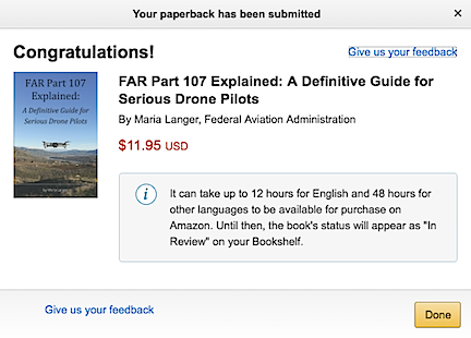
Here’s the dialog that appeared when I clicked Publish.

I clicked the buttons that needed clicking and eventually saw a dialog box telling me that my paperback had been submitted. Although one message had told me it could take 72 hours, this one said 12 hours. Whoa.

I shut down my computer for the day and went about my business. It was only 3 PM. I think I spent a total of 6 or 7 hours on the conversion process.

This morning, a little black dog who will remain nameless in this discussion decided she needed to bark at the coyotes howling off in the distance at 3:15 AM. That was all I needed to wake me up.

I lay in bed for a while with my iPad, checking weather, doing a word puzzle I do every morning, and checking in on Twitter. Then I decided to check Amazon to see if my paperback book appeared. I was very surprised to see that it did.

Book Listing
Here’s my book, all ready for purchase. I think it might be #1 in New Release and #11 in in Books > Arts & Photography > Photography & Video > Aerial because I bought two copies this morning.

Of course, I bought two copies right away: one for me and one for my friend Jim, who got me into drones. The only way I’m going to see the book is by buying it. At least I earn royalties on the purchase.

I guess what blows me away is just how quickly the book was made available. When they said 12 hours, they weren’t kidding. I used standard Prime shipping; my book will arrive Monday because today is a holiday and they don’t deliver on weekends. Still, that means they’ll print and ship the book tomorrow.

If the book looks as good as the ones I get through Lightning Source, I might have a new provider for my limited audience paperbacks. Let’s face it: Amazon sells more books than anyone else. For a book that normally would not appear in a brick and mortar bookstore, there isn’t much of a reason to get it in that Ingram catalog. And although I need to run the numbers, I suspect I might actually make more money publishing through Amazon; I’ll have to do a cost analysis to see.

As for ease of publishing, well, if you don’t try to get fancy and you use the Word template Amazon provides, it’s pretty darn easy to publish a book. So easy that I’m thinking of doing it again this month. The only thing I miss is the flexibility of getting my manuscript just the way I like it. Maybe it’s time to fire up InDesign and use that to create PDFs that KDP can’t change.