Sunrise Flight

I re-experience the magic of getting out to fly at dawn.

The alarm went off at 4:40 AM. Normally, I don’t set an alarm. I’m usually awake by 5 AM without one. In fact, that morning, I was awake at 3:30. But I fell back to sleep and was very surprised when the alarm brought me back to consciousness.

I had enough time to jump in the shower, dress, and make coffee in a to-go cup. Alex the bird and the horses would have to wait. My flight was at 6 AM and I still needed to do a preflight and pull the helicopter out to the ramp.

It was cold and dark as I drove away from the house. I’d taken the doors and windows off my Jeep about two months ago and still haven’t put them back on. The temperature was in the 50s, and I really felt it as I sped down West Wickenburg Way (the old California Highway) to the airport.

The moon was full, casting a blue-white light over the desert landscape. I love to fly in the light of a full moon. The ground is so dark out here in the desert that the moonlight really illuminates things. Sometimes, as I fly back to Wickenburg from moonlight dinner tour in the Phoenix area, I can see the helicopter’s shadow moving along 700 feet below us — a tiny gray dot darting across the washes and along the rolling hills.

I rolled up to my hangar, pointed the Jeep’s headlights at the door, and turned off the Jeep, leaving the headlights on. I fiddled with the combination padlock on the door to get it open, then turned off the headlights. I rolled the right side door open and flicked on the overhead lights. I seldom come to the hangar at night, so I use the lights rarely. They’re bright and fully illuminate the contents of my hangar: Mike’s airplane, my motorcycles, some furniture in storage, my airport “office,” and my helicopter, sitting on its ground handling equipment, always ready to roll out to the ramp.

I did a preflight, checking under panels for fluid levels, tele-temp colors, and unusual signs of wear or tear. I climbed my 10-foot ladder to examine the rotor hub. I checked the tail rotor and the oil level. One of the good things about flying the same aircraft all the time — and being the only person to fly that aircraft — is that you really get to know it. When there’s something wrong, it jumps out at you. Like the tiny crack I found in the plastic part of my clutch activator’s down-limit switch the year before. The crack was only about 1/4 inch long, but I saw it on a preflight. (That turned out to be another case of $1000 in labor to replace a $12 part.)

By then, it was 5:30 AM. Time to get out on the ramp. I hopped in the golf cart that was attached to the helicopter’s tow bar, and began backing out. It’s a tricky maneuver; I have to back straight out about 3/4 of the way to the hangar across from mine to make sure the tail rotor clears Mike’s airplane and the hangar door. Then a sharp turn toward the ramp, which swings the tail out. When the helicopter and cart are parallel to the row of hangars, I’m ready to roll.

But not yet. I had to get out of the cart, switch off the lights, and roll the door closed. I left my Jeep parked as is. It wasn’t blocking anything except my left hangar door and I’d be back before 7 AM.

The sky to the east was beginning to lighten. According to my computer, dawn in Wickenburg would be at 6:17 AM. The goal was to be in flight, flying east when the sun broke over the horizon. I could see now that there was a cloud out there, not far above the horizon. The sun would make its appearance, then slip behind that cloud. The cloud didn’t seem too dense, so I was pretty sure much of the light would penetrate, keeping the sky bright as the sun continued to climb. That was my prediction, anyway.

Zero Mike Lima before DawnI rolled up to the fuel island, set the parking break on the cart, and got out to disconnect the ground handling equipment. That means unfastening the four ratchet straps on the front of the skids, moving the tow bar away, and taking the ground handling wheels off the back of the skids. (You can see a photo of what the ground handling equipment looks like on my helicopter in this article.) It’s a bothersome routine — it would be so much nicer to just land on a rolling platform like Ray and Dave do — but I have it down to a science and can do it quite quickly.

I added 15 gallons of fuel to the main tank. I was expecting three passengers — a dad and his two young sons — and could actually top off the tanks if I wanted to. But I don’t like putting on more fuel than I need (including reserves, of course). With the added fuel, we’d have enough to fly 2 hours. Our flight would take 30 minutes.

Done with all my preflight stuff, I waited. It was 5:45 AM.

The airport at Wickenburg is kind of magical at that time of the morning. The ramp, lighted by a handful of overhead lights, illuminates the few planes parked outside. Every once in a while, one of the lights goes out, leaving the space beneath it in shadows until it recovers from its temporary ills and comes back to life. The rotating beacon — now a cell tower — sweeps its white and green light over the vicinity. If you listen hard, you can hear its motor. You can also hear the sounds of life in the industrial park across the runway: distant banging and clanking one of the small manufacturing facilities, the steady beeep-beeep-beeep of a truck backing up, some voices carried on the breeze. In the past, I’ve heard the mournful mooing of a free-range cow on the ranch (soon to be a housing development) across the road or the call of a coyote.

Zero Mike Lima at DawnIt was the light that fascinated me that morning. The light from the fuel island cast on my helicopter combined with the light of the coming dawn behind it. I pulled out my digital camera — which I keep in my purse — and took a few photos with the flash turned off, using the fuel island equipment and camera self-timer as substitutes for a tripod and cable release. The resulting photos weren’t bad, as you can see for yourself.

As 6 AM approached, I waited over by the terminal building. Before long, a car pulled in and my passengers got out. The sons were somewhere between 8 and 12 years old. The younger one didn’t look very enthusiastic. I gave them the safety briefing as we walked out to the helicopter. The older son sat in front — an arrangement that seemed to make the younger son very happy as he climbed in back next to his dad. I showed them how to work the doors, then closed them in. A few moments, later, I had the engine going and we were talking over the headsets while the engine warmed up.

To the east, the sky had brightened considerably. The cloud hanging out there would make the sunrise interesting. Our normal cloudless skies are wonderful if you like sun — and you’d better, if you come to Arizona — but they make for boring sunrises and sunsets. Today they’d have a bit of a treat. The sun was already illuminating the bottom of the cloud, although there wasn’t much color to its light.

We took off and headed east. I climbed more than I normally would to give them the best view I could muster. It was already too bright for the lights of Phoenix to be very noticeable, which was kind of unfortunate for them. One of the things I like to do at night is launch from Wickenburg Airport, which is in a pretty dark area of the desert, and climb up to reveal the lights of Phoenix stretching from 30 to 60 miles away in a perfect example of urban sprawl light pollution. Terrible for people wanting to look at the stars, but quite beautiful from the air, especially when climbing from the darkness on the edge of nowhere.

My goal was to get as far as Lake Pleasant before sunrise. I made the goal. The lake was in sight with the brightening sky reflecting off its smooth surface when the sun peeked over the horizon.

Of course, that’s also when you could see the streaks on the Plexiglas of my cockpit bubble. That low-lying sun will show how badly I cleaned the bubble, even if I did a good job. At least there wasn’t any dust to make it worse.

I made a gentle turn to the left, leaving the sun behind us. Now we were facing Wickenburg again and could see it in the distance. We also saw Vulture Peak and the full moon as it was descending toward the horizon. The sun cast long shadows in the desert between the hills and mountains. Details of the terrain emerged: a gravel pit, some trailers parked on BLM land, a windmill and tank. I steered us toward Vulture Peak, which my companions planned to climb later in the day. We flew past the east side of the peak, then past the guest ranch where they were staying. A while later, we were touching down gently on one of the heli-spots at the airport. We’d been in the air about 30 minutes.

As I cooled down the engine, my passengers told me how much they’d enjoyed the flight. Even the little guy in the back, who wasn’t scared anymore. I escorted them all back to the terminal and we said goodbye.

It was still early — about 6:45 AM — but the airport’s nighttime magic was gone. Although I was the only one left on the ramp, it didn’t have the same deserted feeling it had had less than an hour before.

I rolled my cart over to the helicopter to put it away. At home, Alex the Bird and the horses were waiting for breakfast.

Why I Don't Share GPS Coordinates Online

I’m vague about locations for a reason.

One of the great things about exploring remote desert locations is that they’re seldom visited by others. And the fewer people who visit an interesting destination, the fewer people have the opportunity to vandalize it.

I’ve seen the results of vandalism firsthand.

  • A huge masonry house overlooking Lake Pleasant was abandoned in the late 1970s or early 1980s when only 75% done. It had windows once, but vandals took care of that and left their shotgun shells and beer cans behind.
  • A pair of cabins dating from the early 1900s in the Weaver Mountains had apple trees growing out front, but campers decided to cut them down for firewood.
  • A rock with petroglyphs carved into it in the mountains near Congress has more modern graffiti than ancient indian drawings.
  • Entire ghost towns in the Weaver, Bradshaw, and Wickenburg Mountains have been wiped off the map by souvenir hunters.

These are only a few of the things I’ve seen destroyed, lost forever. I don’t want to be responsible — even indirectly — for the loss of any others.

Many times when I write about places that are hidden away in the desert, I’m vague about their whereabouts. I know that I won’t damage them. And I know that the people I bring there won’t damage them. But who’s to say what people who get directions or GPS coordinates on the Web will do?

Just today, my friend Ray and I were talking about ATVers exploring all the old mine sites. They come up from Phoenix with their fancy quads, following directions they’ve found on the Web to places like Anderson Mill and Gold Bar Mine. Most of them are respectful of these remnants of our past. But it only takes one with a bad attitude to destroy fragile ruins.

And sadly, there are more than one of these people out there.

The Big Sandy Shoot, Take 2

I return for a weekend-long rides gig.

Last year, I wrote extensively about the Big Sandy Shoot, an event held north of Wikieup, AZ by MG Shooters, Inc. I’d gone to the event at the urging of my friend Ryan, and although I did some helicopter rides, it wasn’t a terribly good gig for me. But it certainly was a fascinating experience.

A few months ago, the MG Shooters folks contacted me, asking me to come to this spring’s shoot. The rich guy with the helicopter who’d shown up last year and had given free rides had sold his helicopter. I wouldn’t have to compete with him. I checked my calendar, saw that Mike and I had the weekend free, and decided we’d try again. I didn’t expect to do many rides, but I thought it would be a nice opportunity to test out our camper in a real off-the-grid situation. We’d leave Jack the Dog and Alex the Bird at home with a house-sitter and just get away for a weekend. If I did rides, great. If not, I’d brought along a book to read and Mike could study for his helicopter check ride, which is later this week.

Getting There

The weather was bad on Thursday and Friday, with heavy rain throughout most of the day. This was good and bad. Good because the shooters would be able to use tracer rounds during the night shoots without worrying much about starting fires out in the otherwise dry desert. Bad because the shoot location is about 5 miles from pavement on the other side of the Big Sandy River. The Big Sandy River does not have a bridge at the crossing, so you have to drive across the river in whatever water is flowing. And the dirt roads often get a top layer the consistency of snot when they get wet.

Of course, I didn’t have to deal with this. I was flying in. What I had to deal with was the weather itself: clouds, rain, wind, etc. We waited until [too] late in the day to make our go decision. Mike pulled out with the camper in tow at about 5 PM and I went to the airport.

In Wickenburg, the sky was partly cloudy and the winds were no more than breezes. I’d checked the weather along the route 93 corridor where I’d be flying, all the way up to Wikieup and Kingman. It didn’t seem bad, but it certainly didn’t seem good. As any pilot who flies in remote areas can tell you, weather forecasting isn’t exactly perfect for areas where there aren’t any airports or cities. So although my destination was 60 miles from Wickenburg, I couldn’t get any solid weather information for it. I had to extrapolate based on what I was experiencing in Wickenburg and what was going on in Kingman, another 30 miles northwest of Wikieup. The radar images helped. And just looking out the window in the direction I had to fly helped.

The plan was for me to fly up there and scout out the river situation from the air. If the river was flowing too swiftly to drive across, I’d call Mike on the aviation radio he had with him and tell him. We’d set up camp at the Burro Creek campground about 30 miles south on route 93 for the night. I wasn’t sure how they’d feel about a helicopter landing down there, but was willing to find out if I had to. (Obviously, I wouldn’t land in the campground itself.)

Because a straight-line route would have put me in the mountains east of route 93, I decided to follow route 93 itself. (IFR: I follow roads.) There were two benefits for that. First, if weather closed in, I could land near a paved road where I could meet up with Mike or get a ride with someone else if I had to. Second, I could check out Burro Creek campground from the air to make sure there were potential landing zones and open camping spaces.

It was an uneventful flight. The winds were not much more than light breezes. Although there were a significant number of clouds at my altitude, none of them were near my flight path. Instead, they obscured the mountain tops on either side of the valleys I flew up. I never got within a mile or two of any of them.

I passed Burro Creek and saw that the campground was about 80% full. I also noted that they’d never painted the second bridge over the canyon there. (I’d taken a photographer from Utah to shoot the bridges from the air as the second one was being completed at least a year before.) I climbed over the mountains there and dropped down into the valley where the Big Sandy River flowed. It wasn’t flowing much at all. In some places, the riverbed was dry, in other places, there was about a foot of water flowing. It was a lot like the Hassayampa River, which flows mostly underground through Wickenburg. I overflew Wikieup, then concentrated on my GPS to locate the shoot site.

It was a good thing I had the waypoint programmed into my GPS. The shoot was quite a bit farther north and east than I remembered. It was in the foothills of the Aquarius Mountains. A line of clouds at my altitude hid the mountaintops from view. The shoot site was about 1/2 mile from the clouds. A bunch of people were set up on the flattened out ridge top with campers and shade structures.

Now, I’d been told that they’d put in two helipads since the previous year. And try as I might, I just couldn’t find them. I circled once, coming quite close to that cloud bank, then decided to land, shut down, and get directions from the ground. I used my cell phone to call Mike and leave him a message about the river conditions — I knew he was too far out for the radio — then landed on the southwest edge of the ridge.

Zero Mike Lima on its helipadTurns out that the helipads were nothing more than just flattened out areas on the north side of the ridge. Someone had decided that the closer helipad would make a great campsite and had set up a ton of camping gear on it. Ed, the guy who runs the place, suggested that he move, but the guy camped out there wasn’t interested in that. He tried to say that it was muddier there than anywhere else. That simply wasn’t true, although the mud leading up to that spot was terrible. So Ed and I found another place on the east side of the ridge. It was higher and dryer and although it hadn’t been cleared for helicopter use, I had no trouble landing there. Best of all, it was closer to where the shooters and spectators would be hanging out, so I was more likely to get people coming over to me.

With the helicopter settled in and the light fading quickly, my thoughts turned to Mike. Last year, he’d gotten lost on his way in from route 93. I didn’t want him getting lost in the dark. So I found someone with a truck who was willing to take me down to the main road and guide him in. That’s when I saw how muddy the road was. It was almost frightening — especially one steep hill covered in reddish brown snotty mud.

We literally almost ran into Mike. He didn’t know I was in the truck, so he didn’t stop. My driver, Ron (I think), made a U-turn and tried to catch up with him. We were more than halfway back when Mike finally stopped and I switched vehicles. We followed Ron the rest of the way up, checked in at the registration area, then climbed to the ridge and parked the camper near the helicopter.

Night Shoot

We were just finishing the camper setup — which included parking its right wheels on five leveling blocks and using large stones to prevent it from rolling away — when the night shoot began.

A big gun. At night.
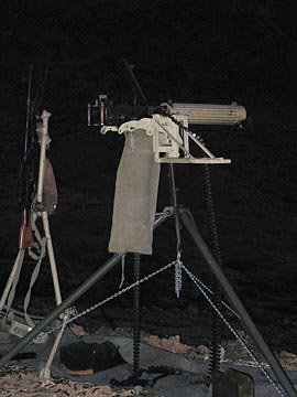
If you’ve never been to a machine gun shoot, you’re missing a really outrageous event. These guys have the same kinds of guns the military has/had for warfare and I think they have more ammo than the military issues to its soldiers. And they’re not afraid to shoot it. At night they use tracer rounds that clearly show the path of the bullets as streaks of red or green light. The sound of fire is deafening and every once in a while, it would be punctuated by the loud boom of a reactive target (i.e., stick of dynamite) going off.

At 10 PM, the shooting stopped. By that time, Mike and I were already in the camper, getting ready for bed. It started raining lightly outside. It got quiet and we slept pretty well.

The Big Day

In the morning, the low clouds were back, but never really drifted into our area. The big camp slowly came to life as shooters woke. The local 4H club was serving breakfast and the bacon smelled excellent. After breakfast in the camper, I went out with some rags to dry the dew off my helicopter. We hung a sign that said, “Helicopter Rides $35” on the back of the camper, which faced the rest of the camp. At 8 AM, I had my first passengers.

I flew much of the day. It wasn’t nonstop, but it wasn’t stop-and-go, either. Generally, I’d get three or four flights in between shutdowns. Then I’d get out and grab something to drink or take a pee or do something in the camper before the next few passengers showed up. Most flights had just two people on board — most of these guys were pretty “healthy” — and I made the flights a bit longer than I needed to. The later flights were a bit shorter — after all, I wanted to make money on this event — and included a view of the little waterfall in the foothills about a mile east of the camp.

U.S. Firepower in WikieupMeanwhile, the shooters were shooting. They started up at about 9:30 AM and stopped at noon for lunch. Then 1:00 PM to 5:00 PM when they stopped for dinner. They kicked off the 1 PM shoot with the detonation of a pig statue packed with explosives. I was in the air when they did it, but my passengers and I saw the smoke out in the target area. Mike said that the car alarms for all the cars and trucks had gone off.

We used our new fuel transfer tank to refuel the helicopter. It didn’t work quite as expected. Mike got tired of cranking after about 2/3 of the fuel had been pumped and made the fatal error of stopping. The fuel drained out of the hose and we couldn’t get the damn pump primed again. So the remaining 1/3 tank (about 8 gallons) remained in the transfer tank. Later, I made a fuel run to Kingman which took about 5 minutes longer than it needed to when I parked the helicopter about 3 feet farther away from the pumps than the hose would reach and had to start up to move it. (I hate when that happens.)

The weather threatened rain to the east and west of the site most of the day. On a few flights into the mountains on the east, I got drizzled on. We saw rainbows, too. But the clouds broke up around sunset. I stopped flying at 6 PM after taking at least 40 people for rides.

We made dinner in the camper and opened a bottle of wine. Outside, everyone was preparing for the night shoot. It got dark and people started shooting off flares. They’d shoot into the air like a fireworks rocket, then explode. A red light would glide to earth at the end of a small parachute, lighting up the range. Occasionally, one would land before it went out, setting a small bush on fire. But the earth was so wet that the fire soon went out.

The night shoot began loudly. Mike and I walked down the back of the firing line, past the shooters, taking photos and videos as we went. Thank heaven for ear plugs.

The Last Day

By morning, the folks who hadn’t left the night before were packing up to leave. There was another shoot scheduled, but only the hard-core shooters seemed interested. I flew another 10 or so passengers. The waterfall was drier and harder to spot in the canyon. Between flights, Mike and I packed up the camper.

I was on the ground when one of the shooters, a man who had made a canon out of a fire extinguisher, shot a red bowling ball over the range. That thing climbed at least 300 feet, with the wind whistling through its finger holes, before crashing to earth. He’d been shooting the bowling balls all weekend, but I always seemed to miss them. Seeing it was a treat.

Mike and I had lunch, hooked up the camper, and prepared to leave. I took Mike on a quick flight up in the mountains before dropping him off at the landing zone. I flew home the direct route, detouring only to peek into Bagdad Mine on my way back. Total flight time for the weekend: 6.2 hours. When I later tallied up the money, I discovered that I did a little better than breaking even. (Should have made the rides a little shorter.) But it was enough to come back.

Heli-Shopping

The latest craze? I wish!

You’ve probably heard of heli-skiing, where they take you to the mountaintop in the ultimate “lift”: a helicopter. And heli-hiking, where they take you by helicopter to a remote trailhead and pick you up someplace equally remote. Well, thanks to one of my regular passengers, I’ve now started doing heli-shopping trips.

Here’s the deal.

Wickenburg has serious limitations on its shopping opportunities. Sure, there’s a great supermarket (which even has a Starbucks now, if you can imagine that) and there are a handful of shops down and around town for buying souvenirs, items for your home, and gifts. And even a little boutique.

But for hard-core shoppers, that might not be enough. For these people, it’s Scottsdale or bust.

Scottsdale, by car, is a good 90-minutes from Wickenburg. And that’s if you don’t hit any traffic and push the speed limit a bit. But by helicopter, it’s only 30 minutes away. The obvious benefit for the shopper: less time in the car, more time in the shops.

Last year, a couple who flies with me every time they come to stay at one of Wickenburg’s guest ranches, drove down to Scottsdale for a shopping day. The weather was awful and rainy and since people who live in Arizona don’t know how to drive on wet roads, the traffic was terrible. When they got to the shops, she got right down to business while he tried, in vain, to get a seat at one of the mall restaurants for lunch and a few hours of reading time. But the mall was packed and he couldn’t get a seat, so he wound up in their rental car in the covered parking garage, reading by the car’s dome light. Then, when she was finished shopping, they had another long, miserable drive back to Wickenburg.

This unhappy memory stuck with them. So this year, when they came to visit, they asked me if I could simply fly her down to Scottsdale, while he did something in Wickenburg that he enjoyed: a round of golf.

I’m never one to turn down a good charter, so yesterday at 10:30 AM, I was winding up Three-Niner-Lima with my eager passenger on board. We had an uneventful flight down to Scottsdale, landed, and locked up the helicopter on the ramp. Then, since I had only one passenger and my Scottsdale airport car is a two-seater, I drove her down to the Scottsdale Fashion Mall and let her loose by herself for four hours. Then I spent the time doing some errands, having a nice lunch, and doing a bit of shopping on my own.

I picked up my passenger at 3:30 and drove back up to Scottsdale Airport. I put the car away and we carried our bags back to the helicopter. I stowed everything under the seats and, a few minutes later, we were heading north for a slightly different route back to Wickenburg that would include an overflight of Lake Pleasant and Castle Hot Springs. We were back on the ramp at Wickenburg in time for cocktail hour at the ranch.

Mission accomplished. In style.

Heli-shopping isn’t for everyone. For one thing, it ain’t cheap, so potential heli-shoppers have to be really serious about their shopping time. And shoppers simply have to say no to that great deal on an end table at Restoration Hardware — or anything else that won’t fit in the helicopter.

But heli-shopping is more than just transportation to the shops awaiting your discretionary spending dollars. It’s a scenic flight from one world (the sleepy retirement community of Wickenburg) to another (the busy city of Scottsdale). The transition from town to open, empty desert to suburbs to city is something to see. And you won’t believe the kinds of things you can see from the air that are simply invisible from the road.

Heli-shopping takes shopping to new highs. Pun intended.

Hopi Tea

A soothing beverage from the Rez.

My first visit to the Hopi reservation was about 6 years ago. I was traveling in my Jeep with two friends. Our main destination was the annual Navajo Nation Fair in Window Rock, AZ, but my friend Shorty wanted to drive through the Hopi Reservation and visit Old Orabi, which is the oldest continually occupied village in North America. Shorty wanted to mail a letter to a friend with the Old Orabi (or possibly Hotevilla) postmark.

The Book of the HopiThe Hopi tribe, unlike many other Native American tribes in the Southwest, is working hard to hold onto its culture and heritage and keep it from being commercialized by outsiders. This is probably why so few people know anything about the Hopi people. Their ceremonies are usually closed to the public — as are entire villages sometimes — and photography is not allowed. The reservation is completely surrounded by the Navajo Reservation in northeastern Arizona and only a few paved roads go through it. There aren’t many shops or restaurants and there are no casinos. The place isn’t very tourist-friendly because they don’t want tourists around. (This may be changing as the Hopi tribe realizes the importance of tourist dollars for the tribe’s economy. I just hope they don’t lose their identity in the process.) You can read more about the Hopi people on the Tribe’s Web site or in The Book of the Hopi by Frank Waters.

With all this in mind, we drove into the reservation and found Old Orabi. I don’t remember much about it. The Hopi tribe are pueblo indians and they built their homes on the edge of the three Hopi mesas: First, Second, and Third Mesa. I remember walking around one of the villages, past ancient stone homes, some of which were still occupied.

Eventually, we got to the post office, which I think was in Hotevilla. I remember this a bit better. It was a standard tiny-town post office with a bulletin board in the outer vestibule, where all the mailboxes were. Shorty spotted an “ad” for blue corn meal. We made a call from a pay phone and were soon on our way to a Hopi home.

It was a more modern home than the stone structures in the old villages. We were invited inside and I remember being surprised at how remarkably “normal” it was. (I don’t know what I was expecting.) We sat on a sofa while kittens played around us. The Hopi woman we’d met there had a big galvanized metal trash can that was absolutely filled with finely ground corn meal. She measured out quantities of the stuff with a round, flat pan not unlike a cake pan and stuffed it into a Blue Bird Flour bag. She told us how the cornmeal had been ground as part of a wedding ceremony. This was the leftover cornmeal from that celebration. When the bag was full, Shorty handed over some money and took the bag. (I wound up buying about half of the cornmeal from Shorty and still have some in stock.)

The conversation turned to dance shawls. A friend of the woman’s made them and had some for sale. Were we interested in seeing them? Shorty was. So we hopped into the Jeep and followed the woman to her friend’s house. The shawls were pretty — square or rectangular with really long fringe — but the colors were too bright and gaudy for my taste. Shorty bought one or two, possibly to be polite. And then we got on our way.

This whole experience really made the visit to the Hopi reservation special to me.

From there, we stopped at the Hopi Cultural Center for a bite to eat. Unlike my companions, I had a traditional Hopi dish that included lamb. This was before the vendors started setting up stalls outside, so after lunch we continued on our way.

As we were leaving Second Mesa, we passed a shop on the left called Tsakurshovi. (Don’t ask me to say that.) We stopped in. It was a small shop that caters primarily to the Hopi people, offering the materials they need to conduct their ceremonies. There were dozens of traditional-style Hopi kachinas — figures carved to represent Hopi religious and ceremonial people — furs, herbs, and more. The shop had two small rooms and a friendly young Hopi man behind the counter.

Turns out, this shop is owned by the Days — Janice and Joe. Janice is Hopi, Joe is not Native American. And it was mentioned in a recent story on NPR, which interviewed Joe’s son, Jonathan. Jonathan grew up spending his summers on the Reservation and the rest of the year in Boston with his mother. He now lives in Flagstaff where he runs a shop that I suspect is very similar to his father’s.

Traditional Hopi Kachinas: A New Generation of CarversI don’t remember why I bought the hopi tea. Perhaps Shorty bought some. Perhaps I asked the guy behind the counter what the bundles of sticks in a Ziplok bag were all about. In any case, I bought a bag of three bundles of sticks for $4.

I also bought a copy of Jonathan Day’s book, Traditional Hopi Kachinas: A New Generation of Carvers, which I had autographed on the spot by the guy behind the counter, Wallace Hyeoma, who happened to be one of the featured artists (page 47). (A year later, I would return to the shop and buy several traditional style Kachinas, one of which was carved by Wallace’s uncle.)

We continued on our way, leaving the Hopi Reservation. Our next stop was at the Hubbell Trading Post, where I wound up buying a Navajo rug. But that’s another story.

Much later, when I returned home, I found the bundles of sticks in my luggage. I boiled some water, broke off a few sticks and leaves, and dropped them in. In minutes, I had a hot cup of some of the most soothing tea I’d ever tasted. Clean, fresh, and simply delicious. No need for sugar or milk or lemon. This tea, like green or jasmine tea, is perfect straight. Now I commonly drink it on cold, lazy afternoons, when I feel a cold coming on, or when I’m feeling blue. To me, it’s like a comfort food beverage.

Those three bundles of sticks lasted a long time. A few years ago, I was back on the Hopi reservation and bought more. But today, waking up with a head cold, I decided to forego my usual morning coffee in favor of the clean flavor of Hopi tea. As I brewed up a cup, I realized two things: (1) the long story of how I’d discovered Hopi tea might be interesting to at least a few blog readers and (2) I was running low again.

I did some research for this blog entry. I discovered that Hopi tea is from a plant commonly known as greenthread and scientifically known as Thelesperma filifolium. You can see some photos of it as a plant and stick bundles, learn how to brew it, and read about its medicinal values on the New Mexico State University’s Medicinal plant Web site. I learned that it grows in abundance in the Navajo, Hopi, and Zuni reservations of the Four Corners area. I also found an online source for purchasing Hopi tea online, High Desert Farmers. High Desert is a small scale grower which sells Hopi tea as traditional bundles (they call it “bulk”), loose, and as tea bags. Since the bundles weren’t available, I bought bags and loose. It cost me $14.50 (including shipping), but saved me a 200+ mile trip to the Hopi reservation.

If you like plain, soothing hot teas like green tea, you’ll probably like Hopi tea. If you ever see some in your travels, I recommend it. And I hope you story of first acquisition is as memorable to you as mine is to me.