Getting hot, tired, and stinky.
The original plan, when I left the house with Jack the Dog this morning, was to go to the airport and wash the helicopter before it got too hot out.
Immediately Sidetracked
It was about 8 AM when I left the house. I stopped off at the supermarket to buy a case of bottled water for the hangar. I store the water in the fridge and bring it on trips for my passengers. I bought Arrowhead because it’s spring water (not from a “municipal source”) and tastes pretty good to me.
At the airport, I swung past the high rent district. That’s our pet name for the newer hangars on the northeast end of the developed area. (Our hangar is in the originally, low-rent district.) I was pleasantly surprised to find quite a few people out: Ivan and Shelley, Dave and his friend (who turned out to be my accountant’s son), and Ray and his mechanic.
Dave is renting space for his Hughes 500C in John’s big hangar while John has his Commander in Colorado, where he’s smart (and rich) enough to live in the summer time. I pulled up alongside the open hangar door.
“Going out?” I asked.
“Yeah. I haven’t flown in a month. I got get the dust off it first.”
“Where are you heading?”
“Well, there’s a narrow canyon with a creek in it up around Hillside. I think there’s a place to land down in there. You want to come?”
I did and told him so. But then Jack and I went to chat with Ivan while Dave dusted his helicopter. And I started thinking that I really should just wash the helicopter.
Meanwhile, Dave and his friend pushed the helicopter out and we closing the hangar door. “Is Ray going, too?” I asked.
Dave told me he might, but not right away. He had some things to iron out with his mechanic. And they were thinking of going to the Weaver cabins instead. The raspberries should be ready for picking.
I told him that I might meet them there. Then Jack and I got back into the Jeep and headed to our hangar where my dusty helicopter waited.
Heli Outings, the Wickenburg Way
I should mention something here. When we go on helicopter outings, we each take our own helicopter. Even though we each have four seats and we seldom have more than one companion, we still all climb into separate aircraft. It’s worse when there’s only one of us in each helicopter.
Dave tells a story about when he, Ray, and Jim explored a plane crash site out in the desert, “Yeah, we burned 90 gallons an hour to get three guys out there.”
In our hangar, I had to make a decision. Go or not go? And if I go, what do I do with Jack the Dog?
I decided to go and to bring Jack the Dog with me. After all, he’d earned his wings over a year before and had flown twice in the helicopter.
I loaded up my little cooler with three bottles of water and an ice pack from the fridge. Then I got Jack’s harness and the saddle blanket we use to protect the back seats when he’s in there. He trotted alongside the golf cart as I wheeled the helicopter out to the fuel pumps.
Meanwhile, Dave had started up his helicopter and hover-taxied to the fuel island. He was shutting down as we approached. The fuel guy came out as I was removing the wheels and I told him to top off both tanks. I had a flight to Meteor Crater at 6 AM the next day and I didn’t want to worry about fueling in the dark.
While he fueled, I tried to put the harness on Jack, got it on sideways, and spread the blanket on the back seats. I patted the seat and he jumped in. Then I fastened his harness to the seatbelt. It was the first time I was flying with Jack without another human on board and I didn’t want him getting excited and jumping into the front seat area. Especially since my door was off.
Ray had pulled his helicopter out of his hangar on its dolly and left it parked on the other end of the ramp. As I started up, he fired his up, too. And Dave started up.
A typical summer Sunday afternoon at Wickenburg’s otherwise dead airport: three helicopters starting up on the ramp.
The Weaver Cabins
Dave made a radio call and took off to the north. Ray hovered over to the taxiway without making a radio call. I didn’t know what he was up to.
“You going, Ray?” I asked.
“No, you go on,” he said. I realized he was still working on things with his mechanic.
I made my call and took off after Dave. Of course, I’d lost sight of him. He had a two minute head start and was flying a dark colored helicopter. I knew he’d be flying low — he and Ray always do — so I figured I’d just stay high. I was approaching Round Mountain near Box Canyon when I tuned into the air-to-air frequency we’d chosen.
“Dave, you up?”
“Yeah. Can you hear me?”
“Yeah,” I relied. “Where are you?”
He told me he was just flying over Ray’s gravel pit, which was out to my left. I couldn’t see him, but I stayed high.
I caught sight of him a few minutes later. “I got you,” I said. “I’ll pull in behind you.”
A few weeks ago, there was a midair collision in Phoenix with two news helicopters crashing into a park. All four people in the two aircraft died. Local helicopter pilots are still pretty shook up over this. I wasn’t flying with anyone unless I could see him.
I dropped down to Dave’s altitude, which was only a few hundred feet off the desert floor. I saw a lot of cows. In the back, Jack was standing up, leaning against the back wall behind the seats. Putting dog hair on the fabric there, I knew.
Dave overflew the ghost town of Octave and then started climbing up the canyon beyond it. I followed. We had a 2,500 foot elevation gain ahead of us to cross over the mountains. Dave took it close to the ground, following the earth up. I flew more conservatively, climbing to maintain a reasonable elevation over the terrain. At one point, my climb rate was 1,000 feet per minute. I realized I was catching up with Dave and reduced power.
Over the mountain, Dave did a pushover into the valley. I can’t do pushovers in my helicopter. Well, not aggressive ones, anyway. No low-G operations permitted. So I dumped the collective and glided down behind him.
Now I’ve been to the cabins about a half dozen times and I’ve always landed in the same spot — a flat spot on the arm of a mountain about 1/10 mile from the cabins. The last time I was there, I set up a line of white rock to mark the spot. But it was also in my GPS. Dave headed toward my spot, then looked as if he was going to land a bit to the east of it. So I moved toward my spot. That’s when Dave realized he had the wrong landing zone and I realized that my landing zone and Dave’s were the same. So I turned 90° and landed on the very edge of my spot, right beside some cacti and bushes where the arm of the mountain drops off. He found a flat spot about 75 feet behind me.
 A while later, we were down in a canyon beside a spring-fed creek. Flies were biting. We checked out the condition of the larger cabin, then examined the raspberry bushes. We were at least two weeks too late.
It was cool and pleasant in the shade, despite the bugs. I wished I worn long, lightweight pants and hiking shoes. At least I had water.
Jack was having a ball, running around and checking everything out.
 We heard an approaching helicopter, then saw Ray circling above the trees. We walked out where he could see us. Although he normally lands in a clearing on the other side of the creek, he found a spot near us. We were back by the helicopters when he shut down. I snapped this photo with my Treo for my TumbleLog. That’s Ray’s Hughes 500D on the right and Daves Hughes 500C on the left with my big fat tail (take it anyway you want) in the foreground.
Ray had two passengers with him and he took them down to see the cabins. He told us that there was a fig tree in a clearing upstream. Figs, of course, are in season right now and everyone loves fresh figs. I still don’t know if he was bullshitting us, but we never found the fig tree and he wouldn’t walk upstream to show us where it was.
On to the Canyon
Dave decided to continue on to his first destination, which was the canyon up near Hillside. One by one, we started off and took off. Ray went first — he wanted to be off the ground before I brought my RPM up to 100% and blew dust into his cockpit. (Both guys fly with all doors off most of the year; I only had one door off because I’ve been flying passengers lately.) Then I went. Then Dave. Ray disappeared quickly. I followed Dave over another mountain and northwest toward Hillside.
I watched Dave fly from my perch about 200 feet above him and 1/4 mile back. He flew close to the ground, following the earth. He’d climb over a small hill and drop down on the other side. I either flew around the little hills or glided over them. I lost him when he reached the boulders west of Hillside, then picked him up again when he climbed into sight for me.
Then he was turning, following a canyon, dropping down even lower.
“Yeah, there isn’t enough room for both of us there,” Dave said into the radio. I looked down and saw Ray parked alongside a stream in the bottom of the canyon.
“Jeez, Ray, there’s barely enough room down there for one.”
“Oh, it’s not that tight,” he told me.
Dave turned and went back downstream. I lost sight of him for a moment, then saw him on a sandbar about 1/4 mile downstream from Ray.
“There’s another sandbar right in front of me,” he told me. “I think there’s room for you.”
But in all honesty the location didn’t seem very appealing to me. It was in full sun and there wasn’t much water flowing. I was wearing Keds, which don’t make very good hiking shoes. And although those guys have more rotor blades than I do, mine are almost twice as long. I needed a good, big spot. I probably could have found one, but I didn’t think it was worth the effort.
Besides, I’d gone to the airport to wash my helicopter and I still had some work waiting for me back in my office.
“I think I’ll just head back,” I told him.
“Are you sure?” Dave asked.
“Yeah. I got work to do. Have fun. Fly safe.”
Ray was still on the radio. “Dave, you on the ground?”
But Dave had either turned off his radio or, more likely, the signal was blocked in the rocky canyon. “He’s on the ground,” I reported. “About a quarter mile downstream. I’ll see you guys later.”
I climbed out and punched Wickenburg Airport into my GPS. I was close to the plane crash site Ray had shown me months ago, but I didn’t overfly it. Instead, I made a beeline back to Wickenburg, by way of Congress. It was a 41 NM flight. I made it in under 30 minutes and set down at the fuel island for more fuel. I’d flown 0.9 hours.
Down to Business
Of course, by that point I was hot and tired. Too tired to wash the helicopter. But I had to get that job done. It was dirty — I’d flown in the rain a few weeks ago and it had gotten badly dusted up at the cabins hours before. My passengers the next day were paying $1,200 for a flight to Meteor Crater and Winslow, AZ (made famous in that Eagle’s song). For that kind of money, they should fly in a clean helicopter.
So I put the helicopter away in the hangar, hopped into the Jeep with Jack the Dog, and drove back to the supermarket. I bought a sandwich, iced tea, and a tapioca pudding and drove back to the airport. I connected my iPod to my boom box, and listened to the last four Grammar Girl podcasts while I ate. Then I tuned in the Future Tense podcast playlist I’d created, rolled the helicopter out, and got down to work.
I hate washing the helicopter on a hot day. The challenge is keeping the water from drying on it before I get a chance to dry it with a towel. My post about washing the helicopter explains the process, so I won’t explain it again here. I will say, however, that I got so hot that I had to hose myself off. Twice. I must have sweat out everything I drank that day.
I put the helicopter back into the hangar and dried it. Then I did some paperwork. Jack hung out under my desk in the back of the hangar. It was too hot, even for him to chase lizards.
Now I’m back in my cool house with a nice cold egg cream in my belly. I’ll shower, put on clean clothes, and get down to the real work.
Chapter 23 awaits completion.

 A quick look at the weather radar shows a Flash Flood Warning. I live right around the “e” in Wickenburg on this map. The storm seems to be moving northeast, which is odd. But I might be reading the motion loop wrong.
 Sitting on our hilltop, we were treated to a beautiful sunset, just before the second storm rolled in.
 I played a bit with my new camera and managed to get some outstanding lightning shots by placing my camera on a snack table with its lens propped up, setting it to shutter speed priority, and setting the shutter speed to 30 seconds. I pushed the shutter release by hand and waited. 15 of the 20 shots I took included lightning. I think this one is the best.
 On our way home, we had a bit of an off-pavement adventure, driving out to Sycamore Point, which overlooks Sycamore Canyon, west of Sedona. The road is usually passable by any vehicle, but it was pretty muddy yesterday and a storm passed though while we where there. There was a great view of the canyon, which is a wilderness area and off-limits to motor vehicles. The light wasn’t favorable for photography, but I took a few shots anyway.
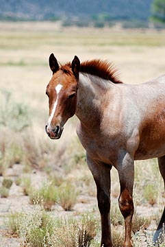 Just past Peeple’s Valley, we stopped for a while to photograph a herd of semi-wild horses. The horses are owned by the Maughan Ranch folks, who turn them out into a 40- to 80 acre pasture. While out there, the mares and the stallions get together. Eleven months later, there are foals. The foals have never been handled by people and are about as close to wild horses as you can get in a fenced-in area. There were about 40 horses out there when we stopped and at least a dozen of them were babies, not much more than 6 months old.
 I wanted to photograph horses in a natural setting, with desert mountains in the distance. But being the time of day it was — nap-time for a horse — they just stood around half asleep on their feet. The babies were curious about us and one, whose mother actually came up to the fence to say hello and get an ear rub, came close enough to touch. But, in general, it wasn’t the scene I was thinking about for photos. The 20 or so shots I took with various lenses were very disappointing. These shots, however, can give you a pretty good idea of the scene.
 The first windmill, the Orofino Windmill, was a non-functioning relic. Its blades were badly damaged, the bar from the windmill to the pump was half gone, and its vane was damaged by shotgun fire. It stood nearly motionless, like an aging sentinel for the empty cattle pens and dry water tanks around it. Beyond it, the monsoon season clouds blossomed and drifted in the otherwise blue sky. Just before we left, a breeze blew the vane, rewarding me with a satisfying squeal as the windmill’s head shifted 10° to the left.
 The next windmill, which was on the right, was in better condition and still functioning. It has no name on my map, but lies at the intersection of our dirt road with a much less-used road. There was a young black cow standing at the concrete water tank when we pulled up, but as soon as we opened the Jeep’s doors, it fled and we didn’t see it again. The windmill spun lazily in the breeze, not making a sound. It was obviously well greased and well cared-for.
 We were probably on that road for at least 45 minutes, always climbing. There wasn’t anything interesting along the way, although there were one or two spots where we could get a view back toward the river. After a particularly narrow spot, we emerged at the top of the ridge where the road we were on intersected with another dirt road, labeled 667 on my map. We turned left, then stopped to consult the GPS map. The photo you see here is looking back toward the road we’d come up on (on the right) and the road we were now on (to the left).
 The vegetation all around us was mostly holly and manzanita. The manzanita have dark red bark and small leaves. It’s a hard wood and is commonly used for perches in parrot bird cages because even hookbills have a hard time chewing through it. Although the bark is normally very smooth, I did find a bunch of trees with peeled, curling bark. There were also some pines, although I didn’t pay attention to what kind. Probably juniper — they were short like the rest of the bushes.
 Although the road we were on curved to the left where it would dead-end just past the remains of the Jersey Lily mine, we turned right onto road 97B, which continued climbing up into the mountains. We made a brief stop at the site of the Big Chief Mine. The access road had long been overgrown with bushes and weeds, but we made our way forward on foot for a few hundred feet. Off to the right, on the side of a hill, we spotted the remains of an old wooden shack. The path to reach it was overgrown and we didn’t dare attempt it in shorts.
 Finally, when it seemed as if we’d reach more well-traveled roads soon, Mike agreed to stop for lunch. It was 1:30 PM. Although it was still raining, we found a spot under a juniper tree where we settled down on the ground and opened the cooler. We don’t picnic with sandwiches, like a lot of people do. We picnic with deli department treats. That day, it was fresh mozzarella “medallions,” thinly sliced prosciutto, marinated whole artichoke hearts, green olives with garlic, and dry salami. Yum. While we ate, we watched the weather all around us. I took this photo of the area to the north; you can see the rain coming down in the vicinity of downtown Prescott, just beyond the hills.
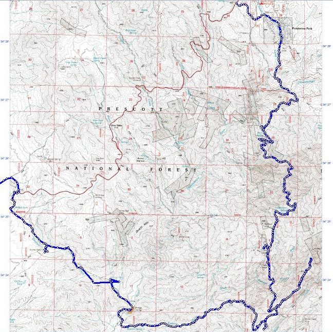
 We always worried about this investment in cactus. After all, when a saguaro dies, it doesn’t do it immediately. It takes years. He guaranteed it for 5 years. In reality, it would take at least that long to die. Although the one in the back yard seems very happy and looks healthy, the one out front has become home to birds, which have burrowed nests in the side of it. And it doesn’t always look as healthy as it should.