Snowbirding 2022: At the BLM Holtville Hot Springs

Another video blog entry from my trip.

I’ll let the video say it all. Here it is, followed by the script I was so obviously reading. (Sorry! I’ll work on eye contact.)

Greetings! Maria here with Lily and Rosie the dogs and Turtleback 2, my trusty truck camper, reporting in from the BLM Holtville Hot Springs near Holtville, California.

We got here nearly a week ago, looking for a warm place to spend a few days. I’ve been coming here for the past six or so years — although I didn’t come last year — so I know the place pretty well. The hot springs is at a BLM Long Term camping area. That means you can pay $40 to camp for up to two weeks or $160 to camp for up to 7 months. I paid for the two-week pass, even though I only expected to stay a few days.

The campground is inhabited by mostly retired folks in all kinds of rigs. Most of them are decked out with solar panels for power. There are also some full-time RVers who either live here a few months or pass through like I do. The campsites are nicely spread out and relatively private. The place is quiet because most folks don’t use generators and it’s not the kind of place that would appeal to rowdy folks.

The main feature here is the hot springs, which is just outside the camping area unfortunately close to Interstate 8. The soaking area consists of three tubs. The large one is very deep — I’m 5 foot 8 and it goes to my shoulders — and usually the hottest one. That one’s overflow goes into a smaller tub that’s shallow and is usually the coolest of the bunch. Those two are both concrete. The third one, which is new to me, is a standard stock tank that can comfortably seat three people; its temperature varies on how recently it was filled.

The hot water comes into the tanks from a Frankenstein’s monster of pipes, valves, and hoses. Below the surface of the largest tub is the valve with the hottest water because it’s closest to the source. From there, the water also goes up a vertical pipe to feed another valve with cooler water (because it’s going through the air before it hits the tub) and finally a rotating shower head. Along the way, there’s a valve and a hose to feed the stock tank.

The whole setup is cleaned weekly on Tuesday mornings by a team of volunteers from the campground using a truckload of equipment. They drain all tanks and use a power washer to clean their surfaces. In the old days, they used to put spa chemicals into it, but they don’t do that anymore. Now they just refill the tanks and they’re good to go for another week. Because fresh water can always be added, the water flushes through nicely and doesn’t really get too gross.

All of the area’s overflow drains into a beautiful pond surrounded by palm trees. I used to see ducks in here, but I haven’t seen any so far this year.

I recommend this place if you don’t mind a more rugged hot springs experience. The tubs are nice but they are shared. Clothing is required — if you strip down, you will be asked to dress. You’re also expected to shower before entering any of the tubs. Common courtesy prevails.

There are a number of hot springs sources in the area. Nearby, there’s a geothermal plant that I can sometimes hear humming if I go out at night and there’s supposed to be another hot spring about 10 or so miles north of here that isn’t quite as nice as this.

My pups and I will be here a day or two longer. This has been my most pleasant stop so far, with great weather, lots of sun, two hot tub soaks a day, and plenty of biking and walking. And the Internet access on my mobile devices is wicked fast. I’m not looking forward to moving on.

Let me know what you think about this video in the comments. If you’d like to see more — including livestream video from Quartzsite, AZ during the big rock shows — please subscribe! And check out my blog for more details about my winter travels this year.

See you!

Snowbirding 2020 Postcards: Painted Rocks Petroglyph Site

I make an unscheduled stop at an interesting place I don’t need to visit again.

After my very successful show at White Tanks Regional Park on the west side of Phoenix, I headed southwest to southeastern California. The goal was to stop in Yuma to do laundry and buy some groceries and then spend a week in the desert near the Holtville Hot Spring.

Along the way, however, not long after I got on I-8 at Gila Bend, I saw a sign for the Painted Rocks Petroglyph Site. I’d lived in Arizona for 15+ years and had never visited this archeological site. I wasn’t in any hurry and I didn’t have anyone expecting me anywhere, so I turned off the freeway and headed north.

The 14 mile road was smooth for the first 5 miles or so. After that, it headed into the hills and got windy. This was unfortunate because one of my new puppies, Rosie, gets carsick. I had her on medication but the drooling started nearly immediately and she lost her breakfast before we reached the park.

I pulled into the campground, which was just past the main parking area, got out with my puppies on leashes, and walked back to the pile of boulders that appeared to be the main feature of the park. I immediately saw a No Dogs sign. I’ll never understand why places in the middle of nowhere that are mostly fenced off anyway don’t allow leashed dogs. We went back to the camper and I tucked them inside, when went back for a walk around the boulder pile.

There were a lot of carvings on the rocks. Most looked like they could be prehistoric, but there were also a bunch from various explorers, missionaries, and other travelers coming through in the 1800s and early 1900s. There was a trail going around the pile and I took it. Most of the markings appeared to one on the southeast side, but who knows? Signs forbid going up into the rocks for a closer look.

Petroglyphs
Many of the boulders had prehistoric markings.

Petroglyphs
Here’s how it works. The rocks naturally form a black color known as “desert varnish.” People chisel away at the black color to expose the natural rock color beneath it. You can see this in many places in the desert southwest.

I took some photos, including two shots of a flower I’d never seen before, and headed back to my rig.

Flowers Flower Closeup
These little flowers were relatively widespread in the area. I don’t know what they are; I still haven’t bothered looking them up.

The campground was nearly empty. I debated back and forth whether I should just camp there for the night. It would be nice to be somewhere quiet with dark skies. I could get to Yuma and then my final destination earlier in the day. With that in mind, I drove through the campground, found a site away from everyone else, and parked.

More campers arrived throughout the afternoon. Despite the remoteness of the area in a valley surrounded by ancient volcanic remnants, my cell signal was strong and Internet access was wicked fast. A rainstorm came through. I went for a nice walk away from the rocks with my dogs. My next door neighbor ran a relatively quiet generator in the evening. It was too cloudy to see stars.

My Rig
Here’s a photo of my rig at the campsite early the next morning before we departed. You can see the pile of rocks that’s the main feature of the park in the space in front of my truck. You can also see Lily the Dog standing up in my truck window.

It had been a relaxing day — something pretty rare when I’m in transit — but I realized early in the morning that I was eager to get to my next destination. By 7 AM, we were back on the road. Rosie, dosed up with her motion sickness medication, hardly drooled before we got to the freeway.

And although I rarely have a “been there, done that attitude,” I had one about Painted Rocks as I drove away.

Snowbirding 2020 Postcards: Last Aerial Look at Camp

I send the drone up for one last look at our camp in relation to surroundings.

Our camp, which was home to six people at its peak, is down to just three of us. Karen and Steve left a little over a week ago; they couldn’t seem to get work done with some much nature to distract them. (Steve loves to go fishing.) Janet left on Sunday morning to set up camp at Tyson Wells in Quartzsite, where she’ll be selling her artwork for the next three weeks. I moved Lily Rose, my mobile jewelry shop, over to my Tyson Wells spot yesterday afternoon. I toyed with moving T2, my camper, over there later in the day but decided I wanted one more night along the river. I admit that I was thinking a lot about Penny, who can be off-leash here. Once we get to Quartzsite, she’ll need to be tied up whenever we’re around other people. The Canadians, of course, are still here and will remain a few weeks after I’m gone.

After doing my last power walk along the levee road and driving down as far as what we call “Janet’s Camp” — maybe 6 miles south? — to see who was camping down along the way, I came back to my much smaller campsite community and sent up my drone for a few late afternoon shots. Here they are.

Campsite Looking West
Here’s a shot of my campsite looking west. In this shot, you can see my path to the levee road and the channel coming in from the river. You can also see the backwater channel on the other side of the road from our site and the island it makes. While everything looks pretty flat in this shot, I’m about 10 feet above the river/channel average level and another 5 to 10 feet below the level of the levee road.

Levee Road
Here’s a shot of the backwater channel south of ours, on the other side of the road with the southern tip of its island. I see here that the opening to the river is pretty much dried up. That huge sandbar would be covered with water when they release enough from Parker and Palo Verde Dams, but right now it looks as if you could walk right down it, wade across the channel, and step into California. The levee road runs in an arc from the right side of the shot to the center. To the end, it’s just 1/2 mile from our camp, making a nice, brisk one-mile round trip walk.

Two Channels
This shot is looking northeast from where the road from our camp makes the turn onto the levee road. You can see the narrow entrance to our backwater channel from the river on the left. Those folks camped on the left are only a few hundred yards from us by air but several miles away by road. The white van on the road belongs to Steve, who had come to go fishing with the Canadians; they’re on their way back here.

Our Camp
Here’s another look at our camp from the air, this time from the west. You can see the top of T2 (my truck camper); my truck is hidden by the tall bamboo. On the Canadian’s side of camp, you can see their fifth wheel and truck, as well as Steve’s van, which has just arrived. If you’ve got really sharp eyes, you can see Penny chasing the van.

I feel extremely lucky to have arrived at this camp shortly after the previous occupants left. This site is one of the best on the river and my personal favorite, mostly because of the long backwater channel for paddling — it goes two miles north, which is almost all the way to the freeway — the privacy, and the relative proximity to pavement (only three miles). I know for a fact that when I leave on Monday, my spot will be taken within two hours.

I’m sad to say goodbye to this camp, but it’s time to move on.

Snowbirding 2017: About the Campsites

And how I find them.

Adventure Truck
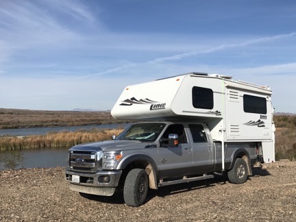
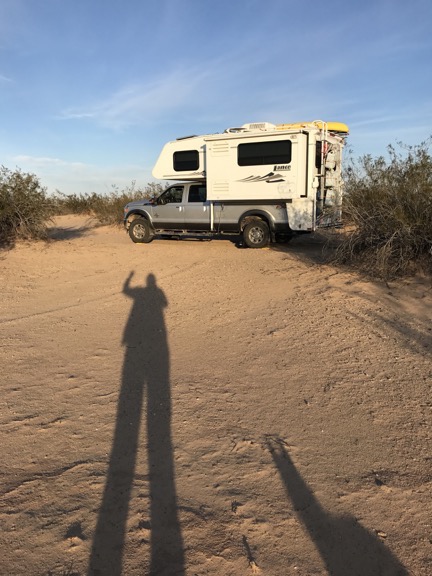
Adventure Truck and the Turtleback off road near Cibola Lake on the Colorado River.

I’ve been on the road since the day before Thanksgiving — an early start to my annual snowbird migration to points south. Other than a little over a month spent at a friend’s guest house in Wickenburg, AZ and three days spent in another friend’s guest house in Phoenix, I’m been camping out in my truck camper, the Turtleback. It’s a fully-contained RV with a queen size bed, refrigerator, stove, convection microwave, sink, and bathroom. It can carry 14 gallons of propane, 40 gallons of fresh water, and a total of 60 gallons of wastewater (in two tanks, black and gray). There’s a propane furnace for cold nights and an AC air conditioner for hot days. The two batteries have plenty of juice for overnight stays, are charged by a solar panel during the day, and can be supplemented by an onboard propane generator with the flick of a switch. With its dinette and refrigerator on a slide out, it has plenty of room for one (or two who like each other a whole lot). Best of all, it can go just about anywhere my truck can go and since my truck is a 1-ton 4WD diesel with high clearance, it can go pretty much anywhere it wants to go.

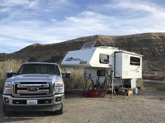
This ain’t no KOA parking lot rig.

Now that I’m back on the road again after my Wickenburg stay, I’ve been sharing photos of my campsites with friends on Twitter and Facebook. The other day one of them asked how I find my campsites. I thought that might make a good blog post.

What I look for

First let me start by explaining what I look for in a campsite.

I want something quiet, private, and safe. I don’t like to listen to generators and I don’t like to close my blinds.

I like a view, but don’t need one. I love camping near moving water or a body of water that’s smooth and reflects the sky.

I must have relatively level ground, although I do have leveling blocks to make minor adjustments if a site has a slope to it. (The camper does not need to be perfectly level.)

I also want something free or cheap or at least worth what I’m paying for it. So far, of the 23 days I’ve spent camping, I’ve only paid for 5 nights. Prices for those campsites — one state park campground, two BLM campgrounds, and two nights at a Las Vegas campground (yes, they have them) — ranged from $5 to $23 per night.

Colorado River
I spent about 10 nights at this free BLM campsite along the Colorado River south of Ehrenberg with some friends. We were on a peninsula and surrounded by water, so I got some fishing and paddling in while I was there.

Because I’m self-contained, I don’t need any hookups or even access to water or a dump station. (This, by the way, is often called “dry camping.”) Picnic tables are nice to have, but I don’t need a fire pit because I don’t usually have a campfire when I’m traveling alone and I have a portable BBQ grill if I want to grill something up. Although these things are nice for long-term stays, they usually come with neighbors so I lose any possibility of quiet or privacy. Those are actually more important to me than the convenience of being hooked up to utilities.

Las Vegas Camping
I spent two nights at a Las Vegas campground so I could take in two shows. At $23/night, it was the most expensive overnight stay, but it had clean, hot, private showers.

I’m not opposed to staying in a regular campground with a full hookup once in a while. It’s a good opportunity to dump my tanks, take a long hot shower, top off the charge on my batteries (if needed), and refill my fresh water tank. But as I recently learned after 10 days of dry camping south of Ehrenberg, my black water tank can hold at least 10 days of waste and I don’t use much fresh water. (It probably would have been a perfect stay if it weren’t for battery issues that were resolved when I left by simply replacing two bad batteries.) But the parking lot atmosphere of most RV parks is a real turn off to me and it irks the hell out of me to pay $30, $40, or even $50 to spend a night there.

Where I look

First, I’ve learned over time where the kind of campsites I want can be found.

When Free isn’t Free
Keep in mind that some areas — including the Icicle Creek area I discuss here — require an access pass for parking. I buy my passes annually and keep them in my truck for hiking and camping, which I do three seasons out of the year. It’s worth it to me and I like supporting the park system.

Public land, including National Forest (NF) and Bureau of Land Management (BLM) and sometimes even State Forest (SF) land almost always has some free “distributed” camping. Distributed camping is camping allowed off forest or desert roads in established campsites that are not necessarily in campgrounds. For example, a drive up Icicle Creek in the Leavenworth, WA, area will take you into National Forest with several established campgrounds. Those campgrounds have level parking space, picnic tables, fire rings, and access to toilets and sometimes even water and you’ll pay a fee to use them. But off the main road are side roads with campsites scattered here and there. Those campsites are usually free.

Did you know that you can camp in the NF just outside Grand Canyon National Park for free? And if you know where to look, you can even find back roads into the park that can help you avoid entrance lines? It’s like camping near your own private entrance to the park.

Near John Day
My Thanksgiving dinner campsite on a tributary creek to the John Day River in Oregon.

Even the campgrounds in NF, BLM, and SF areas can be quite a bargain. On Thanksgiving night, for example, I had an entire campground on a creek in Oregon to myself. My back door looked out over the creek, it was dead quiet and completely private, and I had a picnic table and fire ring if I wanted to use them. There was even a very clean pit toilet a 250 feet from my site. All for $5. I can’t complain, can I?

State and county park campgrounds can also be nice, although they can be spendy and are usually crowded on weekends. Washington state campgrounds can be outrageously priced so I generally avoid them unless they have features I can’t get elsewhere.

How I find them

This is where experience is a good teacher. The more I look for and find sites, the better I become at doing it. And getting a feel for an area is also extremely helpful.

I use a few online tools to get started. I start with Google Maps to get a general feel for the area I want to spend the night. What’s there? Towns? Parks? Points of interest? NFs appear on Google Maps; when I get the name of a NF, I can Google it and get details, including detailed maps that show parking areas and forest roads.

I can also go to the BLM website and search its maps for nearby BLM land. Then I can get details about possible camping areas or campgrounds.

At Walker Lake
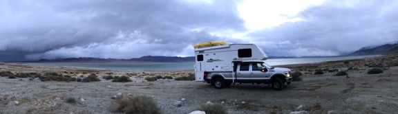
I needed a place to stay near Hawthorne, NV, where I planned to meet up with a friend of a friend. No problem: free camping on the lake on BLM land. Too bad the weather was so stormy!

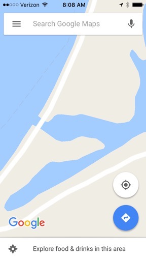
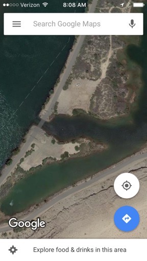
Once I know for sure that camping is allowed in an area, I can use Google’s satellite view to get a look at potential sites. Keep in mind that map view isn’t always accurate — for example, Google maps shows a through road along the levee where we camped in early January; in reality, there’s an inlet cut through the road that clearly shows in satellite view. Satellite view will also show clearings in forested areas, side roads, and even fire pits that indicate an established campsite.

Map View Satellite View
In map view, it looks like the road crosses right over inlet (left) but satellite view tells the real story (right). We camped in the clearing just to the east of where the north side road ends.

Oregon Camping
I had a streamside campsite in central Oregon. There were about two dozen deer roaming the campground when I arrived late in the afternoon. Only five of the 30 or so sites were occupied.

Another somewhat obvious trick is to simply ask around. For example, when I was near Burns in Oregon looking for a place to stay on my way south, I saw some BLM land that showed a campground. It was pretty remote and it was late in the day; I worried that it might not be suitable for me and then I’d be stuck driving at night, which I hate to do. I Googled BLM and found a BLM field office. (The same one that was in the news a lot last year.) I was close enough to drop by and chat with a ranger. He assured me that the campground was open and would accommodate my rig. I made the hour-long drive south and found what might have been the nicest campground so far. I picked a site along the creek and paid only $8/night.

Cibola
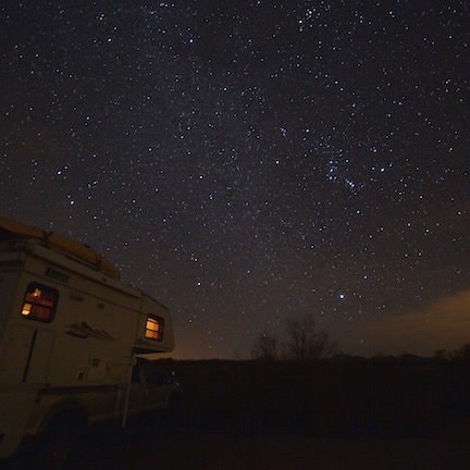
A bonus to this campsite along the Colorado River just outside of the Cibola Wildlife Refuge was the incredibly dark night sky. I got to practice my astrophotography skills not long after sunset.

I also ask friends. The campsites I stayed in last year and this year south of Ehrenberg on the Colorado River were sites my friends knew well, having camped there for many years. My friend Janet showed me other sites. I found still more just wandering around on my own, like a campsite father down the river near a wildlife refuge.

Near the Hot Spring
Greetings from somewhere south of Holtville, CA!

I found the site I was in the last night before my side trip to San Diego (where I am now) by a combination of methods. A friend told me about the hot springs along I-8, although he was pretty sketchy about the name and location. Google maps found the place and directed me to it. A review on Google told me it was BLM with camping available and the reviews were pretty good. The campground host at the long-term (i.e., fee) camping area directed me to free 14-day limit camping about 2 miles south of the hot spring. I drove in, found a level spot, and parked for the night. Only two cars drove past during the 16 or so hours I was there so it was plenty quiet. I got a great night’s sleep — with the bonus of a good hot tub soak in the morning before I hit the road.

I’ll leave San Diego later today and head back east toward Arizona. I’ll spend a night or two in Borrego Springs, following up leads for free campsites with good hiking on BLM and NF land. Then the plan is a side trip to the Salton Sea where I should be able to find a site in the state park there. Then back to Quartzsite for a few days; there’s plenty of free camping out in the desert. After that, who knows? I’m making it up as I go along and only tentatively plan things out a week or so in advance.

I love the flexibility I have on this trip with my smaller rig. I also really love the freedom to make things up as I go along, without having to get approval from (or listen to complaints from) a travel companion. So far, most of my sites have been better than I expected and, as you can imagine, I’m very pleased about that.

I do admit that things can get a bit stressful late in the day when I still don’t know where I’m going to park for the night. But there’s aways plan B: a truck stop or Walmart parking lot. (Fortunately, I haven’t had to resort to either one so far on this trip.) Or a KOA.

Do you have any campsite tips you’d like to share with readers? Please do use the comments link or form to let us know. I’d certainly love to get some new ideas. You can never know too much.

Finding a Legal Landing Zone

It’s not as easy as it seems sometimes.

At Lake Pateros
My R44, parked on the side lawn at the Lake Pateros Inn in Washington State. Sadly, heat from my engine browned the grass.

One of the benefits of operating a helicopter is that you can land it almost anywhere. One of the drawbacks of this, however, is that not all landing zones are legal.

The other day, I was asked by a client to find a pickup location for him that was closer to where he was staying than Scottsdale Airport. He suggested two possibilities that I knew I couldn’t use:

  • A private helipad at the resort where he’s staying. That helipad is owned by another helicopter operator who gets three times what I do per hour of flight time. They do not allow others to use their helipad.
  • A private, residential airport near the resort where he’s staying. They have a strict “no helicopter” policy.

I went through the motions and called the managers of both facilities. I was told what I expected to be told: that I could not use them.

What Do the FARs Say?

Around this time, I commented on Twitter that I was conducting a search. Another pilot, who flies airplanes, wanted to know how I was searching and where legal landing zones were covered in the FARs (Federal Aviation Regulations).

The truth is, they’re not. There’s no FAR that clearly states where you’re allowed to land a helicopter.

Instead, the Aeronautical Information Manual (AIM) offers some clear guidance on where you’re not allowed to land any aircraft. 7-4-6 Flights Over Charted U.S. Wildlife Refuges, Parks, and Forest Service Areas states, in part:

The landing of aircraft is prohibited on lands or waters administered by the National Park Service, U.S. Fish and Wildlife Service, or U.S. Forest Service without authorization from the respective agency. Exceptions include:

1. When forced to land due to an emergency beyond the control of the operator;
2. At officially designated landing sites; or
3. An approved official business of the Federal Government.

I assume this is in the FARs somewhere — the AIM is generally a plain English translation of most FARs, better organized and easier to read — but I can’t track it down.

So Where Can You Land?

A Heli Outing
This heli-outing brought three helicopters, including my old R22, out in the desert near the Swansea Townsite.

When I first started flying helicopters, knowing where you were allowed to land in a non-emergency situation was a big deal. Everyone dreams of landing on their best friend’s driveway or backyard. Was it legal? How about showing up at your kid’s soccer game? Dropping off a friend at work in an office park? Stopping in at Krispy Creme for a donut and coffee? Landing along the lakeshore for a quick afternoon swim?

Is any of this legal?

My answer: it depends.

Before you read any farther, understand that I am not a lawyer. I cannot advise you on these matters. If you get in trouble for landing somewhere and use what you read here as a legal defense, you are an idiot and deserve to lose your license. I’m just sharing what I’ve learned through experience. I don’t know all the answers and certainly cannot advise you in your specific situations.

Landing in the Middle of Nowhere

R22 in Riverbed
A blast from the past: My old R22 sitting in a wash south of Alamo Lake about a day after it flowed. Hard sand makes a good landing surface.

Keep in mind that I live on the edge of nowhere. Wickenburg is on the northwest end of Maricopa County. There’s not much other than empty desert in most directions. Go southeast and you’ll get to the Phoenix metro area within 30 minutes, but go in almost any other direction and you’ll be driving (or flying) for a while before you get anywhere else.

That said, friends and I have landed our helicopters at many remote patches of desert, both privately owned and owned by the Bureau of Land Management (BLM).

I discovered through telephone calls, an exchange of mail, and a $270 fine that I’m allowed to land on BLM land that’s not Wilderness area as long as I don’t do it with paying passengers on board. Commercial flights must have permits for landing on BLM land. And trust me: BLM will drag its collective butt in getting you a permit once you apply for one. It took 18 months for me to get permission to land at the Swansea Townsite and costs $90/year to maintain that permit. (I’ve landed there once with paying passengers in the past three years; do you think I should renew?)

But land on private land just footsteps away from government-owned land and you’re okay — as long as other factors don’t come into play.

Permissions and Local Ordinances

At the Big Sandy Shoot
Parked at the semi-annual Big Sandy Shoot. The event is held on a mile-square parcel of privately-owned land northwest of Phoenix.

What are the other factors?

Well, you need to have permission of the property owner. After all, it is his property. It doesn’t have to be written permission, but if you don’t have permission, you could be prosecuted for trespassing.

You also need to be aware of any local ordinances against landing. Wickenburg has one of these ordinances, although they only seem interested in enforcing it when it’s convenient to them. (This is the case with many of Wickenburg’s rules, especially those regarding zoning.) Scottsdale also has an ordinance.

Moab, UT didn’t have an ordinance until after I landed at a friend’s 2-1/2 acre property there. The cops rolled by and I thought I’d get in trouble, but they just wanted to see the helicopter. A week later, the ordinance came out and was on the front page of the local newspaper. Oh, well.

There are two ways to find out if a locality has an ordinance against helicopters landing within town limits:

  • Land there and see if you get in trouble. I don’t recommend this approach, but it can be effective, especially in remote areas where you might not even be seen by anyone on the ground.
  • Call ahead and ask. In most cases, they won’t know. You can make a lot of calls and get nowhere. Then you can try the above approach and see where it gets you. Hopefully, not in jail.
Helicopter at HouseParked in the desert north of Phoenix. Photo by Jon Davison.

Of course, this refers to towns and cities. Within those are subdivisions that may be controlled by written rules (such as that private airport that won’t allow helicopters). And everything is inside a county, which may have its own rules.

Sounds like a pain in the butt? It is. But if you don’t do your homework before you land off-airport, you’re liable to get in deep trouble with the local authorities and FAA. You could have your pilot certificate suspended or even revoked. I don’t know about you, but I have enough time and money invested in my helicopter pilot certificate, aircraft, and business to act wisely. If I can’t find a legal landing zone where I think I need one, I won’t land there.

Please Read This

Tristan's R44
Before buying my own R44 in 2005, I leased a friend’s. This shot was taken in Congress, AZ, where I attempted to sell helicopter rides a few times.

If you’re landing off-airport, whether you have permission to land at an official helicopter landing zone or you’re just taking a risk landing where you might or might not be allowed to, please, for the sake of all of the helicopter pilots out there, keep these things in mind:

  • Only land where its safe. This applies to the terrain of the landing zone itself, as well as your approach and departure routes. Wouldn’t you be embarrassed if you had a dynamic rollover in your buddy’s backyard?
  • Land at the edge of activity — or farther away, if possible. I used to do rides at the Mohave County Fair. My landing zone was at the far end of the event, beyond the carnival rides. There were many people at the event who didn’t even know there was a helicopter around. I’ve also landed at remote restaurants far enough away that no one even heard me approach.
  • Only land where you can secure the landing zone while the helicopter is running. I’ll land places where there may be people on the ground if I have a second person on board with me to get out and keep the landing zone clear of curious bystanders. But if I’m alone, I wouldn’t even think of landing where someone might approach the helicopter while it’s running. Do you really think it would be a good idea to land at your kid’s soccer game? What if a bunch of those kids ran toward you from behind and ducked under the tailcone? Do I have to paint a bloody picture for you?
  • Do not overfly people, vehicles, animals, or buildings at low-level. This is for courtesy and safety. Engine failure on approach or departure means a possibly messy crash into whatever’s below you. Crashing into an empty parking lot is very different from crashing into a crowded soccer field or county fair arcade. (By the same token, anyone who buys a home within a mile of the approach/departure end of any airport runway should have his/her head examined.)
  • Be courteous to people on the ground. Don’t spend more time than necessary circling the landing zone at low level. Once you know your approach and departure routes, get it on the ground. Don’t give bystanders a reason to complain. That’s why localities make these ordinances. Because some jackass pilot annoyed just the right number of people to get the ordinance voted in.
  • Do not draw attention to yourself. Sure, it’s cool to land off-airport and yeah, everyone will be jealous. But aren’t you above all that? If you can land and depart in such a way that no one even knows how you arrived, that’s even cooler.
  • Do not walk away from the aircraft with the engine running and blades spinning. I can’t believe I have to include this no-brainer on a list, but here it is, for the folks who have no brain and actually leave a running helicopter unattended.
  • If asked to leave, do so quickly and without argument. Be apologetic. Be nice. Don’t be an asshole.

The rest of us are depending on you to act wisely so the FAA doesn’t add a rule that prevents us from landing off airport.

My Advice

Mansion Landing
Parked at the house of some friends just outside Wickenburg town limits. They cleared a small helipad up there for me to use. Photo by Jon Davison.

My advice is that you don’t land anywhere where safety or legality may be an issue. Do your homework and get the information you need to establish whether your landing zone is legal.

Or simply land at the nearest airport. That’s what I’ll be doing for my upcoming charter flight.