Joy-Flying Over Napa Valley

Sometimes it’s nice to treat yourself to an afternoon out.

I went for a joy ride in my helicopter this afternoon.

I hadn’t been flying since last Wednesday when I finished my Part 135 check ride with an FAA inspector from South Dakota. The helicopter was sitting out on the ramp, blades tied down, gathering dust and then standing up to high winds for a week.

Torn Tie Down
Like the helicopter, the tie-downs are now 8 years old. A strong wind earlier this week tore this one.

One of the blade tie-downs had torn and, although it was still holding, I thought I should repair it. So I untied the blades, brought the tie-downs inside, and did some mending. I looked out the back window while I was on the phone with a client, talking about work this coming summer season back home in Washington. My helicopter sat there patiently in the afternoon’s gentle breeze, less than 200 feet away, waiting for me to tie down its blades again.

Or fly it.

So I flew it.

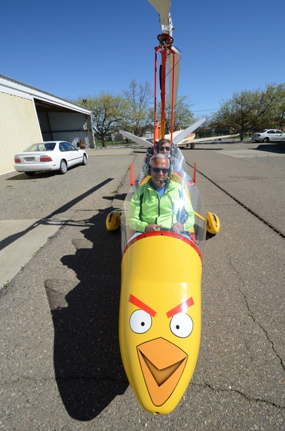
It was very warm this afternoon — in the high 70s here in the Sacramento area. Too warm for the black T-shirt and jeans I was wearing. So I slipped into a tank top and shorts before going out with Penny and my iPad and my GoPro camera.

Penny waited on her bed in the front passenger seat while I preflighted and added a half quart of oil. Then I snapped the camera into it’s “BellyCam” position, turned on its wifi, and climbed on board beside Penny. A short while later, the engine was running, the camera was recording video, and I was listening to classic rock through my Bose headset. I made a radio call to the empty sky around me, eased up the collective, and lifted gently off the ground. Then I was speeding across the runway only 10 feet off the ground, gathering momentum and climbing out into the California afternoon.

As usual when I’m joy-flying, I didn’t have a specific destination. I had some vague idea of flying down to Nut Tree airport (VCB) in Vacaville, which I’ve been told has a restaurant within walking distance. Thought I’d check it out as a possible destination for when my friend George gets back from Alaska and we take turns flying his gyro and my helicopter. But that destination was too close. I wanted to get out for at least 45 minutes. Maybe I’d stop there on my way back.

I wandered south along highway 505 and turned right at Winters. I was following the road that runs to Lake Solano County Park, where I’d gone paddling the previous Thursday, and beyond that to Lake Berryessa. I was flying into the sun, though, and I knew the video wouldn’t be much good. Would it capture any decent footage of that nice canyon going up to the Lake?

Apparently, it did.

Aerial View of Lake Solano Park
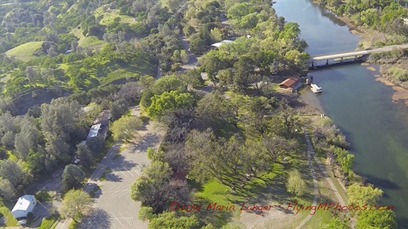
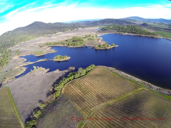
Here’s an aerial view of the Lake Solano County Park. You can see the dock where I put in my kayak last week. I paddled upstream (up in this photo) from there.

I followed the canyon up to the lake, keeping a sharp eye out for wires. There were power poles on the right side of the canyon, but none seemed to cross the canyon. I flew over the dam and headed up lake. The water level was low — California is suffering from a serious drought — but the hillsides were fresh and green from the rain we’d had two weeks ago. Without more rain, the grass would turn brown, possibly before it even got a chance to go to seed.

I saw cattle in the low lands along the lake and ranches up in the hills. Very picturesque.

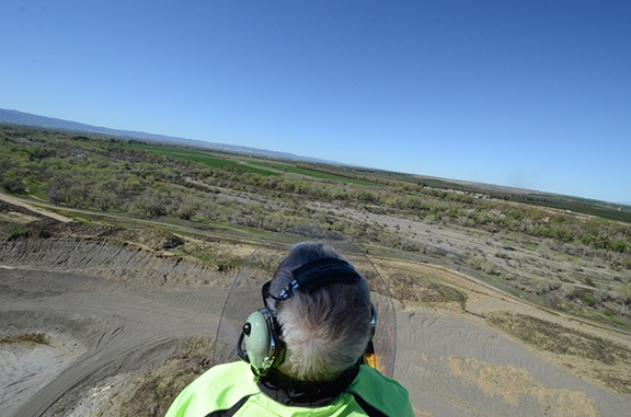
I flew about halfway up the northeast side of the lake with the sun coming into the cabin from my left. Penny, who had been hot while we were flying into the sun — she hasn’t fully shed her heavy black winter coat — was now in partial shade, leaned back in her seat but still panting from the heat. I was comfortable in my summer clothes; I didn’t realize until I got home how much sun I’d gotten. (Next time I’ll wear shorter shorts and really work on my tan.)

Napa Valley Balloons
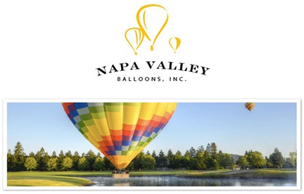
In Napa Valley? Want an amazing experience you’ll remember for the rest of your life? Fly with these guys.

I got the idea that I wanted to see Yountville from the air. About a month ago — the day after I arrived with the RV, in fact, a hot air balloon had landed in my “backyard” here — the airport ramp. I’d introduced myself to the pilot and sent him a copy of a picture I’d taken of him landing, along with a suggestion that we swap flights. He booked me on a flight tomorrow morning at Yountville, at the Domain Chandon tasting room. I wanted to see what it looked like from the air.

Hell, I can come up with an excuse to fly anywhere if I try hard enough.

So I banked hard to the left and flew back down lake. I figured I’d follow the road toward Rutherford and then branch off to the south when I got to Napa Valley. I switched the camera from video mode to time-lapse with shots every 10 seconds. I captured this image as we flew down the lake.

Lake Berryessa
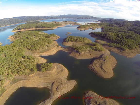
Here’s a shot of Lake Berryessa.

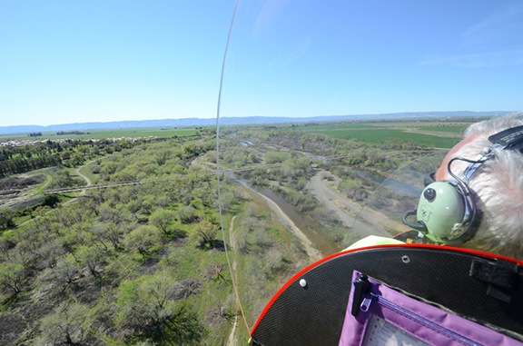
I followed the road I’d driven a few times before, most recently on Sunday, on my way back from Napa Valley. Then I made some turns, following valleys, watching out for power lines. Finally, I popped over some hills and dropped down into Napa Valley over the Silverado Trail.

Silverado Trail
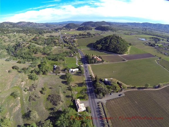
Over the Silverado Trail, somewhere near Rutherford, CA.

Below me, the homes, wineries, and vineyards of Napa Valley stretched in all directions. Although the vineyards were not yet leafing out, there was an abundance of green in the grass, trees, and hillsides. It was gorgeous.

Somewhere around this time, I started thinking of my wasband, as I often do when I have amazing experiences I think he would enjoy. We did more than a few joy-flights together over the years, exploring the desert around our home in Arizona or going further afield, perhaps on cross-country trips to Lake Powell or Las Vegas or Washington State. We shared a bird’s eye view of so many amazing things from the air: the red rocks of Sedona, the blue waters of Lake Powell, the winding path of the Colorado River, the grandeur of the Hoover Dam, the haystack rock formations of the Oregon coast.

As I flew over the vineyards, I could imagine him beside me, trying to identify things we’d seen from the ground on previous visits to Napa Valley. His memory was better than mine — at least before he became delusional — and maybe he’d remind me of things I’d forgotten. Would he spot the winery where they’d served us chocolate cake with our cabernet? Surely it was down there somewhere. He might remember where.

But I reminded myself that any fond memories of my wasband were flawed and false. Maybe he wouldn’t have enjoyed this afternoon’s flight after all. Although he always seemed to like being in the helicopter, especially when he got to take the controls, these days I wasn’t sure what he really thought of those flights. He insinuated in court that he thought they were “work” that, for some reason, he should have been paid for — even though he lacked the pilot certification to do commercial flying and I was always sitting beside him in the pilot-in-command seat. Thinking back on our last few years together, I remember all the weekends he spent in front of a television, watching DVRed car shows. Perhaps he preferred doing that to flying. (He didn’t fly his plane either.)

His loss.

I don’t think I could ever get tired of flying a helicopter, especially on days like today when I’m free to go wherever I like in such a beautiful place. Sure beats anything on TV.

I consulted Foreflight on my iPad and realized I had passed Yountville. I made a sweeping turn to the right, lining up with route 29 on the other side of the valley as I headed north. Moments later, I overflew Yountville and the site I think we’ll be departing from tomorrow in a hot air balloon.

Domaine Chandon
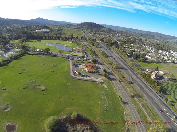
I’m not 100% positive, but I think this is where our balloon will be launching from tomorrow.

I continued up the valley, once again retracing my route, in reverse, from Sunday’s drive. Rutherford, St. Helena, Calistoga. I saw the V.Sattui Vineyard looking quiet and empty on the late weekday afternoon. I saw the main drag in St. Helena. I saw the spas and resorts in Calistoga.

St. Helena
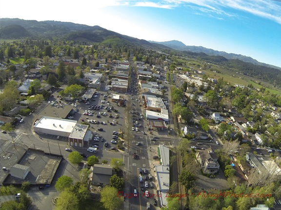
An aerial view of St. Helena in Napa Valley.

At Calistoga, I turned east again. I climbed over the mountains on the east side of the valley and dropped into a rugged canyon. I’d been flying for more than 30 minutes and was starting to think of heading back. I punched a GoTo to my base airport into the GPS and turned in the direction of the line. On Sunday I’d driven past Clear Lake, but I didn’t feel like flying out that way. I thought I’d give Lake Berryessa another flyby instead.

East of Calistoga
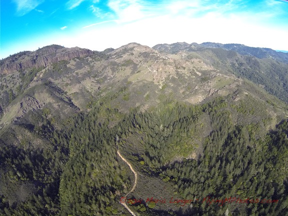
The mountains east of Calistoga are rugged, with basalt cliffs not unlike those near my home in Washington.

Pope Valley
The valley east of Napa — which I think is called Pope Valley — has vineyards, lakes, and ranch land.

Lake Berryessa Narrows
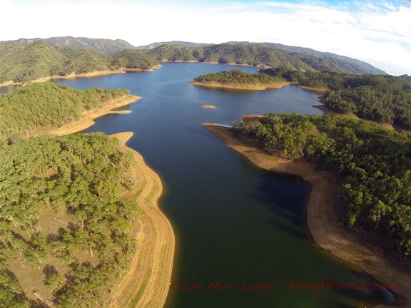
A narrow channel on Lake Berryessa. I had to be careful here; there were wires across the lake nearby.

Dam at Lake Berryessa
The BellyCam just happened to capture this perfect image of the Dam at the lower end of Lake Berryessa.

I flew down the lake, over the dam, and back into the canyon leading to Winters. Then, before I reached town, I headed north in the foothills with the vague notion of overflying the Cache Creek Casino. But before I got to Esparto, I changed my mind. Instead, I turned inbound to my base airport and, after a few radio calls, landed on the runway and taxied into parking. I set it down gently exactly where it had been an hour and 10 minutes earlier.

Penny
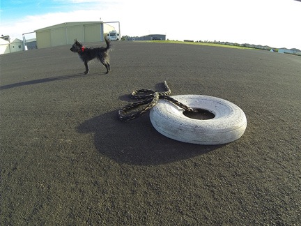
Penny waited for me while the BellyCam continued to snap photos every 10 seconds.

Penny stood up and looked at me, wagging her tail. She was ready to get out. I lifted her out and set her on the ground. She waited at the nose of the helicopter while I cooled the engine and shut it down. The camera caught several images of her standing on the tarmac with my mobile mansion home in the background.

Later, I used the mended tie-downs to secure the main rotor blades and locked up the helicopter.

It had been a great afternoon flight — one I’m glad I treated myself to. I’ll fly again soon — maybe with a balloon pilot beside me and two of his crew in back. Or maybe with my pilot friend George at the controls, exploring a new place. (Something tells me that he’s not very interested in television.) I’ve got a month left here and I plan to enjoy it every way I can.

I never did get down to Nut Tree airport.

Gyro Flight

A friend takes me for a ride in his open cockpit gyroplane.

An Angry Bird
Now this is an angry bird!

One of the great thing about living at an airport is that you’re exposed to neat aviation things on a daily basis. And what isn’t neat about an open cockpit gyroplane sporting a custom Angry Birds paint scheme?

My friend George owns this one. He was at the airport most of this week, teaching a friend how to fly it. Well, he was trying to. The wind howled pretty fiercely on Tuesday and much of Wednesday morning.

George and his Gyro
George posing with his gyro.

(This is a gyroplane or autogyro, by the way. Gyrocopter refers to the Bensen Gyrocopter manufactured by Bensen Aircraft.)

On Wednesday afternoon, George took me for a ride — despite winds 14 gusting to 20. It was an interesting experience for me.

With George
Strapped in and ready to go.

Like helicopters, gyroplanes have a mast and main rotor blades. But unlike a helicopter, a gyro has a means of propulsion — normally a pusher engine/prop. To fly a gyro, you use a pre-rotator to get the blades spinning. You then use the engine/prop to move forward on a runway or other suitable surface. At the right speed, the pilot pulls back on the stick like he would in an airplane to take off. Lift is generated by the rotor blades, which remain spinning in a mode very similar to an autorotation in a helicopter. The engine does not directly drive the rotor blades; the pre-rotator is disconnected before takeoff roll.

Low and Slow
Low and slow in an open cockpit plane? What could be better?

We were airborne for about 20-30 minutes. George demonstrated low flight along a creek bed, high flight, and a power-off landing that had us descending backwards in the stiff wind. (He had to dive to make the runway.) He demonstrated several very short landings and takeoffs. We flew low much of the time and waved at people on the ground waving up at us.

Side View
It’s a great feeling to have nothing between you and the ground you’re flying over.

I thoroughly enjoyed the flight. It reminded me a bit of the powered parachute ride I had a few years ago back in Washington — the closest thing to flying like a bird.

George is a CFI and I’m tempted to take a few lessons. It would be fun to better get to know this kind of aircraft. But there’s no gyroplane in my future — at least I don’t think there is — so getting a gyro rating would probably not be worthwhile.

Still, you never know…

Busting Myths about the FAA and Unmanned Aircraft

A good link to some real information — from the source.

I wrote about “drones” or “UAVs” in two recent blog posts:

The issue is rather polarized, with most pilots and people on the ground wanting more regulation and most drone/UAV operators wanting less. One reader nitpicked over my use of the word “drone” and comparison to radio controlled helicopter — as if one radio-controlled flying object is that much different from another.

If any flying object hits an aircraft in flight or falls from a sky onto someone’s head, it’s going to do some serious damage.

FAA LogoThe FAA, which, like most government agencies, operates so slowly it often seems as if it’s moving backwards, finally woke up and published an update on its website that clears up any “myths” surrounding the use of unmanned aircraft or UAS. Titled “Busting Myths about the FAA and Unmanned Aircraft,” it lists 7 myths and the corresponding facts for each.

Two myth/fact pairs stand out:

Myth #1: The FAA doesn’t control airspace below 400 feet

Fact—The FAA is responsible for the safety of U.S. airspace from the ground up. This misperception may originate with the idea that manned aircraft generally must stay at least 500 feet above the ground

I cannot tell you how many times I’ve heard people tell me that the FAA has no control over airspace near the ground. The number of feet from the ground that the FAA control begins varies from 50 to 150 to 300 to 400. These numbers seem arbitrary to me. The truth of the matter is, FAA-regulated airspace begins in the U.S. at the ground.

Myth #3: Commercial UAS operations are a “gray area” in FAA regulations.

Fact—There are no shades of gray in FAA regulations. Anyone who wants to fly an aircraft—manned or unmanned—in U.S. airspace needs some level of FAA approval. Private sector (civil) users can obtain an experimental airworthiness certificate to conduct research and development, training and flight demonstrations.  Commercial UAS operations are limited and require the operator to have certified aircraft and pilots, as well as operating approval….

Flying model aircraft solely for hobby or recreational reasons doesn’t require FAA approval, but hobbyists must operate according to the agency’s model aircraft guidance, which prohibits operations in populated areas.

Did you get that? Even hobbyists are prohibited from flying their radio controlled model aircraft over populated areas. That includes large gatherings of people for outdoor events.

If you’re interested in this topic, I urge you to read this article on the FAA website. It should help you realize that there’s really no “debate” about this — the rules are quite clear.

More about Drones

Once again, no one is thinking about helicopters.

An aviation friend of mine, Rod, posted a note on Facebook titled “The Drone Industry Should Play by the Rules, or Help Change Them.” I’m not sure if you need to be logged into Facebook to read what he posted, so I’ll just echo it here; I do urge you to read and comment on it there if you can and have something to add to the discussion:

Look folks, I’ve got no problem with drones operating outside the National Airspace System. (i.e. below 400 feet.) 

But if this innovative industry wants to conduct business in the NAS, you should have to play by the same rules as manned systems and certify the operators, the components, and the systems to the standards required by law.

If you don’t like the regulations that currently govern how the NAS is managed, help get the laws changed and deregulate aviation.

If you, like Rod, think that the national airspace system starts at 400 feet AGL, you need to read “Busting Myths about the FAA and Unmanned Aircraft” on the FAA website.

I asked where the 400-feet number comes from, pointing out that I’m authorized by the FAA to operate under Part 135 as low as 300 feet with passengers on board. He linked to an article on Politico about a lawsuit pending by the FAA against an “aerial anarchist” who uses a styrofoam plane for commercial aerial photography. From that article:

The FAA has never officially regulated model airplanes or small drones. The closest it has come was an “advisory” issued in 1981 that created a set of voluntary guidelines for model aircraft: stay within the line of sight, do not fly within three miles of an airport, do not fly a model airplane higher than 400 feet.

The article makes interesting reading, although it entirely misses the point of my problem with the kind of RC aircraft that are becoming more and more prevalent among amateur “drone pilots.” My problem has to do with the operation of these devices in areas where I fly, which can be within 400 feet of the ground, causing a nearly invisible hazard to me and my passengers.

As a helicopter pilot, I have no minimum flight altitude for my Part 91 operations — including aerial photography/videography, cherry drying, frost control, animal herding, wildlife survey — the list goes on and on. Part 91 allows me to fly as close to the ground as I need to (as long as I don’t create a hazard to people and property on the ground, of course). These are legitimate and legal low-level helicopter missions that often keep me within 100 feet of the ground. As previously mentioned, even my Part 135 operations allow me to operate as low as 300 feet above the ground.

Phantom with GoPro
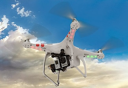
The Phantom 2 Quadcopter with a GoPro Hero attached. This aircraft can weigh nearly 3 pounds. How’d you like to get hit on the head with that dropping from 400 feet?

Imagine this scenario: I’m drying a cherry orchard and a local photo hobbyist decides to take out his Quadcopter with GoPro to get some footage of me or another cherry drying pilot in action. He keeps a respectable distance but is not prepared when one of us suddenly lifts up away from the trees and moves to another orchard. We don’t see him — we’re focused on our work and the location of other helicopter traffic — and one of us flies right into him. The helicopter’s cockpit bubble is smashed or the main rotor blades are damaged or, worse yet, the tail rotor is taken out and the aircraft crashes to the ground. Who’s right or wrong here? The drone is operating under 400 feet and at least 3 miles from the airport, so he’s “legal.” The helicopter pilots are performing a mission that we’ve been doing for years, relying on proven safety measures and radio communication to avoid obstacles and other traffic. Are we supposed to keep an eye out for amateur RC aircraft operators, too?

My aviation friend, Rod, suggests that drone operators should “help get the laws changed and deregulate aviation.” Does he really want aviation deregulated? Does he really want a free-for-all by anyone with a few hundred dollars to spend on an RC aircraft to fly it wherever they like for whatever purpose they desire?

Doesn’t he realize that it’s only a matter of time before they stray up into his previously safe airplane altitude?

Quadcopter
The Phantom Quadcopter is small and white, less than 14 inches wide. I’ve seen birds bigger than that.

And what are helicopter pilots supposed to do? How do you think I feel worrying that any one of my flights could be ended by a collision with an RC aircraft piloted by a hobbyist with a new toy who doesn’t care about the rules or safety? Someone who mistakenly thinks it’s my responsibility, while cruising at 80 knots, to keep an eye out for his toy? Something that might not much larger than a Frisbee?

And make no mistake about it: an impact on a main rotor blade or tail rotor could disable my helicopter and cause a crash.

What would I like to see? Here are a few suggestions for the operation of unmanned radio or computer controlled aircraft:

  • Limit amateur/hobbyist operations to designated RC aircraft fields that are marked on aeronautical charts.
  • Require professional/commercial operators to receive training and pass tests established and overseen by the FAA.
  • Require professional/commercial operators to publish NOTAMS whenever an operation outside an RC aircraft field is conducted.
  • Require all operations to be conducted with a spotter to keep an eye out for full-sized aircraft operating in the area.
  • Limit all operations to altitudes below 300 feet AGL.

I firmly believe that these aircraft, when operated by amateurs, are a danger not only to other aircraft but to people on the ground. There have been numerous crashes in populated areas, including one in Manhattan, and even a death attributed to a crash. How long will the FAA wait before it steps in and properly regulates these aircraft? These aircraft are proliferating at an alarming rate. As a pilot and property owner, I’m starting to get tired of worrying about the consequences of a careless operator’s actions.

And no: deregulating is not the answer we need.

February 26, 2014 Update: The FAA has spoken.

Today’s 5:44 AM Phone Call

A drawback of having just one phone for business and personal use.

Early Morning
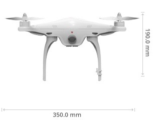
The phone rang at 5:44 AM.

I was still in bed, but awake and reading. I’d slept great, hitting the sack at about 10:00 the night before and sleeping soundly until about 5:30 — close to eight hours of uninterrupted rest! My “morning routine” starts in bed, reading and sometimes doing a crossword puzzle on my iPad until it starts getting light outside. I was in the reading phase of that routine when the phone rang.

No one likes getting a phone call “in the middle of the night.” Now I know it wasn’t the middle of the night, but it was early enough to make me wonder what was important enough to call someone when they’re likely to be sleeping — obviously an emergency.

The phone said the call was from “Palmdale Area.” I only know one Palmdale, and it’s in California. In the seconds before answering, I consulted the database in my brain, trying to think of who in California would be calling me so damn early. One of my frost clients, maybe?

“Flying M, Maria speaking.” That’s the way I answer the phone when the call is either from a known client or an unknown caller.

The person on the other end seemed mildly surprised that I’d answered. “Is this Maria? Did I get you up?”

“Yes, it’s Maria but no, you didn’t get me up. Who is this?”

“Oh, this is Joe. I’m in Wickenburg right now.”

Joe is the name of the man who was gracious enough to offer me his house for the winter while he went to Arizona. (Well, it isn’t really Joe, but neither was the caller’s name. I’m hiding their identities for privacy sake. The names were the same.) Wickenburg was the town I used to live in in Arizona. Although it didn’t really sound like the Joe I know, I assumed it was him and that he’d come to Wickenburg and needed something from me, a former resident.

Of course, that assumption quickly evaporated as the caller hurried on. “I understand you used to run the FBO here. I emailed you the other day. I need a helicopter here.”

I remembered his email. Like most of the other email I get from people who have contacted me from Flying M Air’s website — where it clearly says I no longer operate in Arizona — I’d deleted his message. My bad.

“I don’t operate in Arizona anymore,” I said, starting to lose my patience. (How much patience do you have at 5:44 AM, less than 10 minutes after you’ve woken up?) “I don’t know of any operator in the area who can help you.”

I was ready to hang up but he wasn’t.

“Well, I need a helicopter here and was hoping you could refer me to someone who has one.”

“I was the only commercial helicopter operator in Wickenburg,” I told him. “I never had enough work to support my business there. I doubt whether anyone else would be stupid enough to start another helicopter charter business in that town.”

“Yeah, but maybe an ag ship? Something like that that I might be able to get my hands on?”

I might have laughed into the phone. “There are no ag ships in that area. There’s no agriculture in Wickenburg.”

“Yeah, I didn’t think so.”

I wanted to get off the phone and, at about this point, I started thinking about just hanging up on him. Seriously: I was that annoyed. But I really don’t want to be rude to people.

“You might try one of the operators down in Phoenix,” I told him.

“Yeah, I guess I could do that.” A pause, then: “Hey, did you hurt your foot about six years ago?”

Convinced I hadn’t heard him right, I said, “Excuse me?”

“Did you hurt your foot about five or six years ago?”

“No,” I replied.

“Okay.” Another pause. “Well cherry drying work must be doing pretty good for you up there.”

I couldn’t believe it. This guy called me at a quarter to six in the morning and was trying to have a conversation with me. “It’s fine,” I told him. I sat up in bed. Nature was making its first call of the day. I wanted to be off the phone. “Listen,” I said, “Do you realize that it’s a quarter to six in the morning?”

“Well, I’ve been up for two hours.”

“Maybe you might want to wait until at least eight before calling people?”

“Yeah, but I’m Florida and I run on east coast time. It’s nine o’clock there.”

I thought to myself: Who the hell cares what time zone you operate on? You called someone in Washington. But I said: “I really can’t help you. Sorry.”

“Okay. Goodbye.”

I heard him disconnect before I was able to push the end button.

I guess it’s time to revisit the Do Not Disturb feature on my phone.