Cross-Country by Helicopter: E25 to BFI

14.4 Hours over four states.

Cross-Country, Defined
For those of you who are not pilots, allow me to explain the term cross-country as used by a pilot. A cross-country flight is basically any long flight with a landing a certain minimum distance from your starting point. For airplane pilots, it’s at least 50 miles. For helicopter pilots, it’s at least 25 miles. So while this blog entry discusses a very long cross-country flight, we did not fly all the way across the country.

This past Thursday and Friday, I flew by helicopter with two other helicopter pilots, Ryan and Bryan, from Wickenburg, AZ to Boeing Field in Seattle. Bryan and Ryan did just about all of the flying. I sat up front being a nervous passenger when we were near the ground and playing with the radio and GPS. Brian let me make most of his radio calls on the first day, but I didn’t get to do much of that the second day.

It was a mutually beneficial journey. I needed to get the helicopter from Arizona to Washington State. Ryan and Bryan were both CFIs who wanted to build time in an R44 helicopter. It was way cheaper for them to fly with me on this trip than to rent an R44 from a flight school. There was also the added experience of planning and executing a flight through unknown terrain, with fuel stops and an overnight stop along the way. And the money they paid to fly my aircraft helped me cover the cost of this very long and very expensive helicopter flight. Win-win.

Corona Fuel

A very cool but very helicopter-unfriendly fuel island at Corona Airport in California.

Our flight path took us west, with Bryan at the controls, along state route 60 to I-10, across the Colorado River, and then along I-10 through Bythe, Chiriaco Summit, Palm Springs, and Banning; then back on 60 past March to Riverside on the 91. We stopped at Corona for fuel at what’s likely the coolest but most helicopter-unfriendly fuel island in the world. (We didn’t notice the separate fuel island more suitable for helicopters until we’d stopped and shut down.)

Here’s a video of our transition along the California coast through the LAX airspace on the Shoreline transition route. You might want to turn down the sound while playing it; lots of helicopter noise.

Then Ryan took us west on 91 through the airspace for Fullerton and Long Beach, with a Torrance low pass. (Robinson has entirely too many helicopters waiting for owners on its ramp and in its delivery room.) He then got clearance for the Shoreline helicopter transition of LAX space, which requires the pilot to drop to 150 feet 1/4 mile offshore to pass under LAX departing traffic. We continued following the coast up past Santa Monica, Pacific Palisades, Malibu, Oxnard, Ventura, and Santa Barbara. By then, the marine layer was moving in, so we went inland for a bit. Eventually, we reached San Luis Obispo (and the chatty controller) and stopped for fuel and lunch.
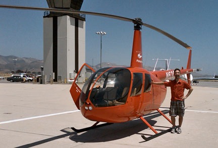
Ryan at San Luis Obispo

Here’s Ryan on the ramp at San Luis Obispo before departure northbound. I shot this one with my Blackberry’s camera, so pardon the quality.

Bryan was back at the controls for our departure northbound. After a very close call with a large bird, we followed the path of Route 101 northbound. Most of the route was up a riverbed in a very pleasant valley. We got to Salinas and realized that any coastal route would be out of the question — the marine layer was creeping in even there. So we headed over the mountains, eventually ending up in the western part of California’s Central Valley. We stopped for fuel at Byron.

Ryan took over and we continued north over Rio Vista and Yolo, finally hooking up with I-5. We followed that through endless farmland — much of it flooded for a crop that apparently needs lots of water — over Willows Glen and Red Bluff, with more than a few crop-dusters flying nearby at altitudes far below ours. We stopped for the night at Redding, tied down the helicopter, and got a hotel shuttle into town.

We’d flown 8.8 hours.
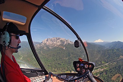
Ryan Flying Near Mt. Shasta

Ryan at the controls as we near Mt. Shasta in northern California.

The next morning, we were back at the airport at 9 AM, preflighting and getting ready to go. Ryan would start the flight. We headed north along I-5, over Lake Shasta and past Mount Shasta, which was snow-covered and beautiful. We were now past Central Valley’s vast farmland and up in the mountains. We flew past Weed, Siskiyou Co., Rogue Valley/Medford, and Grant’s Pass. Much of this flying was in canyons, along the same route as I-5 and a train line.

Things turned a bit iffy as I-5 swung to the east. We were hoping to go north and catch it on the other side of some mountains, shortening our route a bit, but clouds sitting on the tops of those mountains made that a bit uncertain. So we dropped altitude, slowed down, and followed I-5. Ryan flew while Bryan and I kept a sharp lookout for the power lines we knew — from both chart and GPS — were ahead. We weren’t that low and there wasn’t any real danger, but we were certainly not coming out of that canyon anywhere except the I-5 corridor. We passed the powerlines with plenty of room. The road descended into a valley and we stayed up beneath the cloud bottoms. Eventually, the sky cleared. We continued along I-5 past Myrtle Creek and Roseburg and stopped at Cottage Grove State for fuel and lunch.

Then it was Bryan’s turn again. We continued up I-5 past Hobby, Albany Municipal, and McNary. Then we headed northwest over Sportsman’s, Hillsboro, and Scappoose. We crossed the Columbia River and headed north on I-5 again over Kelso Longview and Olympia, with nice views of Mount St. Helens and Mount Rainier in the distance. Then on to Bremmerton, where we stopped for fuel. We probably had enough to make the last 20 minutes, but why take chances?

At BFI

Zero-Mike-Lima on the ramp at BFI. Another Blackberry photo. And yes, that’s Mt. Rainier in the background.

I flew the last leg with Bryan up front to handle the radio and give me directions. It was only a 15-minute flight, but the airspace was complicated, so I was grateful for the help. I set the helicopter down sloppily in the parking area. We’d flown a total of 14.4 hours.

It was a great flight. We saw so much that most of it is just a blur in my mind. With luck, these photos and videos will help me remember the trip for a long time to come.

Many thanks to Ryan and Bryan for accompanying me on this trip. I hope they learned a lot about cross-country flying.

The Challenges of Aerial Photography

It ain’t easy.

A lot of people think that aerial photography is easy. Go up in an aircraft and snap a photo. What can be easier than that?

Truth of the matter is, it’s not as easy at it seems. Mike and I learned this a while back, when we attempted to provide aerial photography services when I owned an R22 helicopter. And as a business person, photographer, and pilot, I have a unique perspective on the topic.

The way I see it, problems fall into three areas.

Client’s ability to accurately communicate what he wants a photo of.

Some clients — those are the folks who want the photos — simply can’t communicate what they want a photograph of. Couple that with their unreasonable expectations of what the photographer can do and the photographer’s failure to communicate his limitations and you’ve got a recipe for disaster.

Take, for example, one of our early photo shoots. A guy owned 10 acres of land southwest of Wickenburg. He hired us to photograph it from the air so he could use the photograph as a selling tool. What he failed to explain is that he expected a straight-down image, almost like a super zoomed in satellite view. The aircraft that take those kinds of photos are airplanes with belly cameras flying at 10,000 feet or higher. We can’t shoot straight down with our setup. The client said he wanted a photo of his land from the air. When we provided a very usable image from 1,500 feet up, slightly to the south, the client was very disappointed.

If you’re reading this as someone who needs aerial photos of a specific place, take the time to talk to the photographer and tell him exactly what you need. Draw pictures if you have to. Make sure he understands and can deliver what you need.

Photographer’s ability to communicate what he wants the pilot to do so he can get the shot.

This is the one that I, as a pilot, run into all the time. This problem appears to break down into three separate causes.

  • The photographer thinks I’m a mind-reader and that I know what he wants to shoot, so he doesn’t provide instructions. When I don’t get the aircraft in the right position, it’s my fault because I couldn’t read his mind.
  • Horseshoe Bend with Plane
    My helicopter was part of the equipment for this shot by Mike Reyfman. We were in an OGE hover 2,000 feet above the canyon when this plane came into view 1,000 feet below us.

    The photographer doesn’t understand exactly what a helicopter can do. Yes, if it isn’t too windy or we’re not too heavy or high, I can hover on point so you can get the shot. Yes, I can make a sharp turn — left or right — around the target. Yes, I can climb almost straight up (or descend almost straight down) to change the angle of the shot. Yes, I can fly sideways, at slow speed, to keep the target in frame. Yes, I can chase the target at almost any altitude or speed needed, keeping the target in front, beside, or behind the aircraft. But if the photographer doesn’t ask for any of these things, I’m not going to volunteer them. After all, I’m just the pilot — not the photographer.

  • The photographer seems almost afraid to ask me to fly the way he needs me to. Maybe he’s flown with other pilots in the past who simply would not perform the maneuvers he needed. (I get a lot of my Phoenix-area photo business because one local helicopter operator refuses to fly below 300 feet or slower than 60 knots — not exactly flexible enough for aerial photography.) Some photographers may believe that all helicopter pilots set arbitrary limitations on how they’ll fly and don’t want to push. I don’t know about you, but if I’m paying a pilot $450/hour to fly me around to get the shots I need, I’m going to ask him to do exactly what I need him to do. If he says no, I won’t push. But if he says no to everything I ask, I’m not likely to call him again.

Pilot’s ability to put the aircraft where it needs to be to get the shot.

Sometimes the pilot just can’t do it. This could be because of lack of skill, lack of aircraft performance capability, or lack of space for maneuvering the aircraft:

  • Wheat Harvest
    My buddy, Jim Van Sky, was flying his helicopter in central Washington state last summer when he put me in position to get this shot. Jim is a highly skilled pilot with plenty of experience taking photographers around. It was a pleasure to shoot with him at the controls.

    Skill is pilot-specific. Either he has the skill or he doesn’t. He might not have it this year, but he might have it next year — that’s why it’s always a good idea to work with an experienced pilot. I know I can safely perform certain maneuvers now, at 2,100 hours flight experience, that I couldn’t even dream of performing when I was still building my first 1,000.

  • Aircraft performance is aircraft-specific. I can’t tell you how many times I’ve heard photographers choose an R22 instead of an R44 or an airplane instead of a helicopter just to save a few bucks. When will these people learn that the aircraft is part of the equipment? Would you do the shoot with a disposable camera if a professional level Nikon or Canon were available? Yeah, the pro camera will cost more, but it’ll do a much better job. The same goes for aircraft. Airplanes simply lack the flexibility of helicopters for serious aerial photography. Yes, you can often get the same shot from an airplane, but it’ll take the pilot twice as long to get into position and to get back into position for the next batch of shots. And while you’re getting into position, you can’t get all those other interesting shots you might see because the wing strut or prop or some other airplane component is in the way. (And yes, there are exceptions to this, but they’re mostly customized solutions, such as the aircraft flown by photographer Adriel Heisey.) As for R22 vs. R44 (or any other larger helicopter), unless both you and your pilot weigh under 150 pounds and you’re flying with half tanks of fuel at sea level on a cool, calm day, you’re asking for trouble flying a serious photo mission in such a small aircraft. It simply does not have the performance needed for challenging maneuvers or high density altitude operations. The photographer in this aircraft learned the hard way.
  • Rainbow Bridge
    My husband, Mike, took this shot of Rainbow Bridge a few years ago. It’s tough to get a shot better than this from the air.

    Location isn’t always accessible. Sometimes there just isn’t enough room in the air around the target to get into position. Here’s a good example. I take a lot of photographers over Lake Powell. Many of them want to shoot Rainbow Bridge, which is in a deep, narrow canyon off the lake. Because of the nature of the canyon and its surroundings and the weird wind patterns that sometimes set up in there and the general high density altitude conditions that prevail at Lake Powell, the closest I can get to Rainbow Bridge is about 500 to 1000 feet above it. I won’t hover there — if we get into a settling with power situation, there’s simply no way out. I always do it as a slow fly-by, circling as needed. That’s the best I can do. Part of it is skill and part of it is aircraft performance (or my understanding of it though 800 hours of stick time in that aircraft), but most of it is the sheer difficulty of the terrain around the target. I’m not willing to descend down into a canyon that I may or may not be able to safely climb out of. There are plenty of other places like this where, for one reason or another, the aircraft just can’t get into the perfect position for the photographer to get the shot.

And then there’s the photographer.

San Francisco
I was a passenger on my own helicopter when I shot this view of San Francisco with the marine layer moving in beneath us.

None of these points take into consideration the photographer’s skill, his choice of lenses and other equipment for the shoot, and the suitability of the subject matter for aerial photography.

Some photographers just don’t “get” aerial photography. That doesn’t mean they won’t. It just means they need to think it out beforehand, give it a few tries, analyze the results, and try again until they do.

Or maybe it just isn’t for them.

But when done right, aerial photos can be a truly amazing look at our world.

How to Start Your Own Helicopter Charter Business

A guide for the folks who really want to know.

Lately, I’ve been getting a lot of blog comments and e-mail messages from wannabe helicopter pilots. They’re seeing the reality of the current helicopter job market: too many entry-level pilots, too few jobs, low starting pay, and training that’ll cost them $60,000 to $80,000.

On Job Markets & Flight Schools

They might be reading about this in a post that remains the most popular of all time on this blog: “The Helicopter Job Market.” I wrote this piece just over two years ago, in March 2007 at the height of Silver State’s rise to power as a helicopter flight school. I was tired of seeing young guys (mostly) get conned by promises of $80,000/year jobs that just didn’t exist for newly minted commercial helicopter pilots. I wanted to warn them, but without actively speaking out against Silver State and the companies that had adopted their strategy to turn a quick buck. In all honesty, I didn’t want to get sued. I just wanted readers to consider reality before signing on the dotted line.

We all know what happened to Silver State. It was a Ponzi scheme of sorts that built a massive flight school on the money of tomorrow’s students. When students stopped signing up — due to their inability to get financing or a case of the smarts — and bills came due, Silver State collapsed, leaving many students in debt without their certificates and hundreds of low-time pilots looking for work. It’s a tragedy, not only for the people scrambling to pay the cost of the flight training they may or may not have gotten, but the dumping of so many low-time pilots on the job market made it easy for employers to pick and choose and drop pay rates. The best of the desperate got the entry level jobs they wanted. The others were left out in the cold.

And when the economy began to tank, even the employers cut back. Big seasonal employers at the Grand Canyon and Alaska hired fewer pilots than ever this year and even employers in the Gulf of Mexico began laying off pilots.

The Do-It-Yourself Alternative

Some wannabe pilots think there’s another way to build a flying career, a sort of do-it-yourself method.

Maybe they see from this blog that I didn’t go the usual route — that is, private pilot to commercial pilot to certified flight instructor to get that first 1,000 hours to get an entry level job, etc. Instead, I got my commercial ticket and started my own helicopter charter business. Then I got a bigger helicopter and a Part 135 certificate and, for all appearances, seem to be happily raking in the dough while flying around in my own helicopter.

That’s what they see, anyway.

Lately, they’ve begun commenting on this blog and sending me e-mail, asking for advice. While requests for advice from new or wannabe pilots aren’t anything new, what is new is that the advice they want is about how to start their own helicopter charter companies. Apparently, they believe that since they won’t be able to easily get a job, they will be able to start their own business as a kind of “shortcut” to the career they want.

Here’s My Approach

So I’ve written this blog post to answer these questions from my experience. Here’s my step-by-step approach. If you’re looking for the secret of my success, you might want to print this out for future reference:

  1. Spend $50,000 to learn how to fly helicopters and get a commercial helicopter license.
  2. Spend another $30,000 to $50,000 to build time so you can fly safely under most conditions.
  3. Spend $346,000 or more to buy a helicopter, about $10,000 per year to maintain it, and $12,000 to $32,000 a year to insure it.
  4. Spend 4 to 24 months preparing the paperwork and working with the FAA to apply for a Part 135 certificate. Then take and pass a Part 135 check ride. Then repeat the check ride process every year.
  5. Spend another $10,000 to $30,000 on advertising and marketing.
  6. Take lots of calls from people who can’t understand why you can’t fly them around for the cost of fuel or want you to fly them for free or are trying to get you to donate to their charitable cause. Then get the occasional call that leads to real work for someone who appreciates what you do and understand what it costs.
  7. After ten years and close to a million dollars spent building and maintaining your business, sit back and watch your investment in time and money languish in an economy where few people want to or can spend money on your services.

Get the idea?

At the Big Sandy Shoot
My $346,000 investment, parked at an event in the desert.

There’s an old saying: “The best way to make a million dollars in aviation is to start with two million dollars.

I’m not complaining. It’s nice having a helicopter. It would be even nicer if I could afford to fly it whenever I wanted to.

But the simple reality is that starting a helicopter charter business is a huge money suck. My aviation business spends more money than most pilots earn each year. If I didn’t have another good source of income, I wouldn’t be able to afford having this business at all.

In Conclusion

If you think that starting your own helicopter charter business is a quick and easy, money-saving way to build a career as a helicopter pilot, think again. It’s neither quick nor money-saving.

But sure. It’s easy. Just add time and money.

How Much Wind is Too Much Wind?

For helicopters, that is.

Tomorrow, I’ve got a lengthy charter booked with a new client. It’s an animal survey mission, which will likely require me to fly low and slow over varied terrain. The job’s starting airport is at 5,600 feet, so the whole job will be at high density altitude. Fortunately, there’s just two of us on board, so power shouldn’t be much of an issue.

Unless the wind becomes one.

When I checked the weather on Saturday for Tuesday, it was forecasting winds 12 to 24 mph with gusts up to 37. I imagined myself battling a 13 mph gust spread with a tail wind when I was flying at 40 to 60 knots. It wasn’t a pretty picture.

I e-mailed the client and suggested that we move the flight up to today (Monday) or earlier on Tuesday, before the wind kicks up. I knew he was traveling, so I figured I’d follow it up with a phone call later in the day.

When I checked it again last night, the winds in that area had dropped considerably and forecasted gusts were only 25. That was more reasonable. I called the client and left him a voicemail message on his cell phone, explaining the situation and offering to change the date and time, but not making it seem so urgent.

This morning, the forecast is as follows for tomorrow in the flight area:

Sunny, with a high near 72. South southwest wind 7 to 10 mph increasing to between 15 and 18 mph. Winds could gust as high as 30 mph.

I sure wish the National Weather Service would make up its mind.

So the question is, how much wind is too much wind to fly?

My Experience with Wind

Although I liked (and still like) my primary flight instructor very much, there were two things he “babied” me on in initial training:

  • Radio work. I was crappy on the radio — which is odd, considering how well I can let my mouth run when around family and friends — and he made it a non-issue by handling many of my radio calls for me. I developed an early attitude of avoiding radio communication with ATC by actually altering routes to avoid airspace. I’ve since gotten over this problem and will talk to anyone on the radio.
  • Flying in wind. If wind speeds got over 8 or 10 mph, he’d cancel our lesson. I don’t think it was because he was afraid of the wind — he had over 1,000 hours of flight time. I think it was because he was afraid of letting me try to fly in the wind. Maybe he was worried I’d have a lot of problems. It didn’t matter. He made me afraid of the wind, which is ridiculous when you consider I’m flying a helicopter and can take off or land into the wind anywhere.

As a result of my initial training, I always faced windy flying days with caution. Maybe too much caution.

I remember flying my R22 from Wickenburg, AZ to Placerville, CA years ago. I was supposed to do it in one day. I got an early enough start. But I hit windy conditions at the Tehatchapi Mountain pass where I’d planned to cross from the high desert near Edwards Air Force Base to California’s Central Valley. Anyone who knows the area shouldn’t be surprised. It’s lined with dozens, if not hundreds, of windmills for a reason. But I was afraid to brave the pass and wound up spending the night at Rosamond, CA. I don’t recommend doing that and I certainly won’t do it again.

Could I have made the trip safely? Nowadays, I think I could. But then, I wasn’t sure.

I built all my flying time in my own aircraft on personal and commercial flights. When I got to 1,000 hours, I applied for a job at the Grand Canyon. I had a friend who recommended me to one of the tour operators there. I had a good interview and got the offer. Flying at the canyon had always been a dream of mine, so I happily took the job.

One thing about Arizona in the spring is that it’s windy. One thing about northern Arizona in the spring is that it’s very windy. I soon learned not only how windy it could get at the Grand Canyon, but how much wind we were expected to fly in.

Our company had two methods for determining whether it was too windy to fly:

  • We’d fly until one of the pilots came back and said it was too windy. Now most of the pilots were guys and most of them were in the 24 to 30 year old range. They spent their pilot lounge waiting time watching car races and extreme skateboarding shows on the television there. There was a definite testosterone thing going on. Obviously, if you came back from a flight and said it was too windy to fly, you were a sissy. So none of the young guys did it. There were also two women on staff, including me. Neither of us would call it because then we’d be confirming that we were sissies, which the guys already suspected. (Frankly, my personal gauge of what was too much wind was way off and I couldn’t trust my judgement anyway. I figured if it wasn’t too windy for everyone else, it couldn’t be too windy for me.) Fortunately, there was an older pilot named Ron who didn’t care about macho bullshit. When Ron went out on a flight and got tossed around too much in the sky — usually by the Dragon’s Tail or Dragon’s Head (two calling points on the Dragon Corridor) — he’d come back in a huff, go straight to the lead pilot, and shut us down for weather. The rest of us would breathe a silent sigh of relief.
  • When the wind in the company’s tower at the Grand Canyon Airport hit 50 miles per hour, we’d shut down. And yes, if Ron wasn’t around, we’d sometimes fly right up until that point.

So, as you can imagine, I quickly learned how to fly in high winds.

LTEThe only time I got into any real trouble was one day when I was landing on a pad in front of our terminal at the Grand Canyon. There was a good, stiff crosswind coming from my left as I hover-taxied into position. I was flying a Bell 206L1 C30P Long Ranger. Anyone with any experience in Bell products should be able to imagine what a 1000-hour pilot brought up in Robinson equipment might experience in such a situation: LTE (loss of tail rotor effectiveness). I started rotating to the right. I added left pedal and nothing happened. I added more left pedal and got a tiny bit of response. I was now almost 30° off center and my tail would soon be approaching the fuel pit. I slammed the left pedal to the floor, spun the nose of the helicopter around to face the front of the pad, and brought the collective down swiftly, for a rough yet straight landing. It was my first LTE experience and it scared the hell out of me. Robinson puts a hell of a lot more authority in its tail rotors than Bell does.

As another flight instructor once told me, “The wind is your friend.” He was right — but I couldn’t understand why until I’d flown in windy conditions. That taught me how the wind could help me take off and land with a heavy load or get to my destination faster. And how it forced me to dance on the pedals for a crosswind landing, or milk the collective to avoid the [over-]sensitive low rotor RPM horn on takeoff or landing.

The Risks of Wind

LTE is only one risk of flying in windy conditions. As I fly tomorrow, any time I’m in a crosswind situation, I need to worry about the aircraft trying to weathervane into the wind. If the wind is from the left, LTE becomes an possible issue — although I’ve never had an LTE problem in a Robinson. We’ll be flying light with just two on board, so I should have enough power to handle the situation. The trick will be to either avoid it (which I prefer) or recognize the onset and avoid it before it causes a problem.

Another risk of high wind to semi-rigid rotor systems (which is what most two-bladed systems are) is excessive flapping. This was our main concern flying Long Rangers at the Grand Canyon in high wind. (And you thought it was pilot air sickness.) When Ron came back and shut down flying for the day, he’d come into the pilot room and tell us all how crazy we were for flying. It was dangerous, he’d say. But what did we know? We were 1000-hour pilots, many of whom had no real life flying experience. How many of the former flight instructors around me did what my first CFI did and keep their students — and themselves — out of the wind?

My main concerns tomorrow will be keeping the aircraft under perfect control as I fly a search pattern. There will be a lot of turning back and forth and maybe even a little hovering. I’ll have to keep track of where the wind’s coming from and what low-level obstacles — think hills and ridges — it has to cross to get to me. Each little bump in the ground means a bump in the air on a windy day.

How much wind is too much?

I know a lot of pilots who won’t fly in what I now consider moderate winds (10 to 25 mph). This past February, I was in Parker, AZ, doing a video flight for an off-road race. There were a bunch of helicopters working for various race teams or video production crews. Before dawn, as the cars were lining up at the starting line, they took off, one by one. The winds were 13 gusting to 18. I was prepping my passengers for the flight when the pilot of a Jet Ranger came over and asked if I was going to fly. I told him I was and I think he was surprised. He told me it was too windy for him.

Anyone with significant flight time who reads this should be able to give me an idea of their own personal maximums for wind. I’d love to get your feedback here. Use the comments link or form. And if I’ve said anything absolutely stupid in this post, please correct me gently.

At this point, I’m thinking that 30 mph with a gust spread of no more than 10 mph should be okay for this mission. If I find out I’m wrong, I’ll be sure to let you know.

In the meantime, I’m hoping my client calls to start the mission an hour or two earlier. I think if we can finish up before noon, we’ll avoid the worst of the wind.

Weight & Balance Woes

Or why I had to turn down a potentially lucrative charter flight.

One of the things I’ve said again and again is that it’s nearly impossible to load a Robinson R44 helicopter out of CG. Nearly, but not completely.

What is CG?

For those of you unfamiliar with the term CG, it stands for center of gravity. All aircraft have a specific center of gravity or point at which they could (theoretically) be lifted and hung level. While an aircraft doesn’t need to be in exact balance to fly, there are limitations to which it can be loaded out of balance. These limitations form an envelope of acceptable loading and if you’re loaded within this envelope, you’re said to be within CG or simply in balance. The aircraft controls are rigged with this in mind.

If you load an aircraft out of CG, you’re asking for trouble. For example, if I load my helicopter too heavy on one side, I could run into trouble in a turn by not being able to move the cyclic enough in the opposite direction to come out of the turn. After all, all controls have limits, normally defined by a physical stop. Running out of right cyclic while trying to come out of a left turn would be very scary indeed. Of course, I probably wouldn’t get to that point because I’d feel the problem as soon as I pulled up into a hover — I simply wouldn’t be able to keep the aircraft from drifting left.

[Note to all you flight instructors out there; if I completely mangled this description — since I’m not a CFI — feel free to step in to clarify in the Comments. This is my understanding after 10 years and 2,000+ flying hours, but I never had to teach it to anyone.]

Pilots are required to have an aircraft Weight and Balance (W&B) calculation on board for every flight. This is part of the Federal Aviation Regulations (FARs) in the U.S. In non-commercial flight, it’s usually enough to have the W&B for the empty aircraft. But in commercial flight, there are usually requirements for an individual W&B to be calculated for each flight with the given load.

So yes, when you fly on a commercial airliner, there’s a computer program somewhere that’s spitting out a W&B calculation for your flight. Your pilot has it in his possession in the cockpit.

Now you might say, “Hey, wait a minute. How do they know what I weigh?” They don’t. They’re allowed to use estimates. It all depends on the airline’s Operating Specifications (Ops Specs), which are established with the FAA.

I have Ops Specs, too, but I’m not allowed to estimate for my Part 135 Charter work. That’s why I ask for the name and weight of each passenger when I book a flight.

Four Fatties is Too Many

When I asked for names and weights yesterday while booking what was supposed to be a 2-hour aerial survey charter, I got three weights that I knew would be trouble:

A: 240 lbs
B: 220 lbs
C: 195 lbs

That’s 655 pounds of passengers alone.

Add the pilot (who is trying hard not to reveal her weight; don’t do the math, guys!) and you could only put on about an hour and 20 minutes worth of fuel to stay below the 2500 lbs max gross weight — the absolute maximum weight of the aircraft at takeoff time — limitation of my Robinson R44 Raven II.

Of course, the situation gets worse when you factor in the simple fact that all passengers lie about their weight. Every single one of them. If I put a scale out and made them stand on it, I guarantee anyone over 200 lbs. has shaved at least 10 pounds off their weight when reporting it. They either don’t figure the weight of their clothes or they’re in denial about their weight or they’re afraid that I’ll say they weigh too much. Even folks under 200 lbs are guilty of this. So I routinely add 10 pounds for each passenger. That 30 pounds corresponds to 5 gallons of 100LL fuel or 15-20 minutes of cruise flight.

Since I’m really supposed to have 20 minutes more fuel on board than I expect to need — per FAA reserve requirements — I was really sunk. Apparently, I’d be able to load up my passengers and just enough fuel to take us on a brief flight around the departure airport.

This is just the weight portion of the equation, which is easy enough to do. Add empty aircraft weight to passenger, baggage, and pilot weight. Then add the weight of required fuel. If the number exceeds 2500 lbs, something’s got to come off the aircraft. It can’t be the pilot and it can’t be the fuel required to complete the mission. Simple as that.

How the CG Stacks Up

While I could have done the math in my head, I did it as part of a complete CG calculation. It’s a pain in the butt do to one of those manually, but I have a spreadsheet solution that I worked up to do it for me. I punch in the weights and amounts of fuel and it draws the CG envelope with points for takeoff weight and empty fuel weight. So while manually doing this task would likely take 15-20 minutes of calculator punching, I can do it in about 30 seconds. I can also easily play “what if” by changing fuel quantities and moving the passengers into different seats.

Here’s what I got for the proposed flight and 2 hours of fuel on board:

Weight and Balance Example

Note that both points (square and triangle) are outside the boundaries of the CG envelope. The red line indicates the rotor mast. The points clearly indicate that the CG is way forward. In other words, I’m front-heavy. If I pick up to a hover, I’m likely to start drifting forward immediately. I may hit the back stop of the cyclic when I try to stop that forward motion. In other words, I won’t be able to stop.

Of course, the aircraft is also 100 lbs over weight.

Just for grins, I moved the passengers around in a what-if scenario. I’d put the biggest guy up front, since that’s where the leg room is. After all, maybe he’s not fat. Maybe he’s a former professional basketball player. It doesn’t matter for my calculation how tall a person is — all I care about is weight. But if he’s got long legs, he’s likely to be miserable in the back seat.

So I put the light guy up front and got something like this:

Weight and Balance Sample

A little better, but not safe or legal. But I kept playing. I really wanted to do this flight. The only thing left to fiddle with was the fuel, so I started off-loading fuel on my worksheet until I got within weight limitations. I needed to drop 99 pounds to get down to 2500 takeoff weight. That’s 16.5 gallons or about an hour’s worth of fuel. This what-if scenario would produce be for a short flight, with only 56 minutes of fuel on board:

Weight and Balance Example

And this is where the sad truth of the matter emerged. It didn’t matter how little fuel I had on board — we would always be out of CG for this flight. Too many fatties on board. Both points remain outside the envelope.

I called the client back and told him the problem. I said that together, we weighed too much. I gave him two options: leave one of the passengers behind or fly with a company that had larger aircraft. I suggested a company based in Scottsdale. He wasn’t happy, but he understood.

I’ll be interesting to see if the big fatty (A in my list above) gets left behind. If he does, we’ll be good to go — with full tanks, as you can see here:

Weight and Balance Example