The 2012 Buckeye Air Fair

Some small towns really know how to put on an airport event.

Yesterday, for the fourth (or possibly fifth) time, I participated in one of the nicest airport events in Arizona: The Buckeye Air Fair. The event was held annually for several years until 2009. It moved to Gila Bend for at least one year and I turned down an offer to participate because of the distance. I was thrilled to ask to participate again in the 2012 event when it returned to Buckeye.

I flew almost nonstop yesterday from 9 AM to 5 PM, with only short breaks for an airport closure (for an RC aircraft demonstration) and refuelings. There was a constant stream of people coming on board, aged 3 through 73. Although I missed the rest of the event — being stuck in the cockpit all day — I had a great time and met lots of really great people. I don’t think I’m exaggerating when I estimate that I took at least 50 people for their first-ever helicopter ride. For some of them, our flight was their first ever time airborne.

Interested in what you missed? Check out this video by Arizona Public on YouTube. You’ll see a couple of shots of me and my bright red helicopter.

Thanks again to Margaret and Steve and the rest of the folks at Buckeye for making this such a great event for everyone.

More GoPro Camera Tests, More Aerial Photos and Videos

Another chapter in my never ending saga: any excuse to fly.

Early this week, it rained.

That might not seem like a big deal to most folks, but it rains very seldom in Arizona. In fact, I hadn’t experienced a good rainstorm since my drive back from Washington state in October.

This week, it was cold and rainy for two days in a row. With rain comes three things:

  • Clouds, which make our normally plain blue sky more interesting and give it depth.
  • Cleansing, by which I mean that the dust is washed off the desert rocks and plants, making their colors more vibrant.
  • New growth in the desert, which makes everything look just a tiny bit greener than it otherwise would.

You need to be a desert dweller to really appreciate these things.

There’s nothing I like more than to go flying over the desert right after a good rainstorm. So on Wednesday, as the storm clouds moved north and blue sky started to appear again, I loaded up my GoPro cameras and mounts, hopped in the car, and drove up to Deer Valley Airport, where my helicopter is living part-time this season. When I arrived just before 9 AM, my helicopter was sitting out on the pavement, ready for me to preflight, set up my cameras, and go.

The Camera Setup

I took my time about setting up the three GoPros. I have three different models and I use each one for a different purpose.

  • GoPro HD Hero2 Professional – With its sound-in port and better lens and recording capabilities, I normally mount it on the helicopter’s nose as the “nosecam” and connect it to an audio-out port I had put into the helicopter a few years back. It captures not only intercom communications, but all radio communications. Basically, anything I hear in my headset is also sent out through that port to my GoPro. Here’s an example of an image from the video on this camera, shot at 720p:
    Bartlett Dam Nosecam
  • GoPro Hero HD Original – I mount this between the helicopter’s two back seats, inverted, to capture a wide-angle view of what’s going on inside the helicopter and beyond. This “cockpitcam” view works fine with passengers, but it doesn’t give a close-up view of the instrument panel. For that, I need to mount the camera forward, on the bar between the two front seats. Here’s a view from the camera as I had it mounted Wednesday, also shot at 720p video:
    Back Seat View
  • GoPro Hero 960 – Because I haven’t been exactly thrilled with the 1080p video coming out of my original GoPro HD Hero, when I decided to invest in a second one, I went with the cheaper model, which can’t shoot 1080p video. Instead, it shoots up to 1280×960. I like the widescreen format, so I shoot 1280×720. I saved about $100. On Wednesday, I used a new skid mount and set it up to snap a 2592 × 1944 still image every 10 seconds. (In the 20-20 vision of hindsight, I should have set it up for every 2 seconds; 6 shots per minute isn’t quite enough when you’re cruising at 100 miles per hour.) Here’s a sample image from that “skidcam”:
    Bartlett Dam

So to summarize: I set up the helicopter as a camera mount for three different cameras: 2 shooting video and 1 shooting stills.

The Flight and Some Photos

I turned on all the cameras, climbed into the cockpit, and started up. Five minutes later, I was overflying Deer Valley Airport at 500 feet AGL, northbound. Here’s a nice shot of the airport from the nosecam:

Deer Valley Airport, Northbound

The beauty of all this was that with this setup, I’m able to capture images from three cameras without having to even think about any of them. Absolutely no distraction for me, allowing me to keep my full attention on my primary duties as a pilot: aviate, navigate, and communicate.

The flight was not quite what I had in mind. I was hoping to overfly Lake Pleasant and get all the way to Wickenburg. But as I neared Lake Pleasant, I saw low clouds over the lake. There was mountain obscuration to the northwest — which means the clouds were pretty darn low, since those mountains aren’t exactly lofty peaks. Here’s a nose cam image of the marina at Lake Pleasant near the dam; you can see the low clouds at the north end of the lake:

Marina at Lake Pleasant

I wasn’t very interested in getting images and video shot in overcast conditions. So I decided to head east, where the sky was clearer and sunlight was filtering through to the desert floor.

There was a balloon flying southeast of Lake Pleasant and I tried to get some shots of it with the skidcam. Trouble is, the GoPro’s very wide angle lens exaggerates the distances. If I wanted a good shot of the balloon where it looked close, I’d have to get much closer to the balloon. While I think I could have gotten closer safely, I didn’t want to give the balloon operator or his passengers heart failure so I stayed clear. This is the best I could get; again, a shot every 2 seconds would have given me more to choose from.

Hot Air Balloon

As I flew east, the two front-facing cameras were pointing toward but not exactly into the sun. GoPro cameras get their best images when the sun is at an angle of at least 60 degrees from the lens. According to the LightTrac app on my iPhone, at about 9:45 AM the sun was at about 140 degrees. I was flying at about 90°, so the sun was at 50° angle to the front-facing cameras. At the same time, it was at a 40° angle to the skidcam, which was facing almost due south. (Obviously, I didn’t look up the angles while flying.) As a result, the images from this leg of my flight were pretty disappointing. Here’s an example from the cockpitcam as I flew over the intersection of I-17 and Carefree Highway:

I-17 and Carefree Highway

I flew all the way out to the Verde River and then headed up the river as far as Bartlett Dam. The two photos near the beginning of this post shot nosecam and skidcam views. Since more gray skies and low clouds covered Bartlett Lake, I turned around and headed south. The cockpitcam shot near the beginning of this post shows my view as I headed approximately southwest. After a tiny bit of shallow canyon flying (see nosecam photo below), I headed toward Scottsdale where sun, low clouds, and rocky outcroppings made for interesting views.

Canyon Near Verde River

I got a nice shot of Pinnacle Peak from the skidcam at several altitudes for use in a book project I’m working on.

Pinacle Peak

I also got nosecam and cockpitcam footage as I approached the peak. Interesting to see the difference between these two views, shot at about the same time.

Approaching Pinnacle Peak

Approaching Pinnacle Peak

By that point, I’d been in the air for about an hour and thought I had enough footage to test my setup thoroughly. I headed back to Deer Valley. The one mistake I made was that I flew along side a power line, with the power line on my right — right in the view for my skidcam. This was very unfortunate because the camera was facing north at this point and could have captured a lot of nice footage. Instead, all the footage features the damn wires.

Wires in my Photos

I guess that proves that I wasn’t really thinking much about the cameras.

And for those who are interested in such things, this is the track log of where I flew, as recorded on my iPad.

Track Log

The End Result

In all, I got just over 300 photographs and 2 hours of video — an hour from each camera. Quite a bit of it is useable and will likely appear in edited video content I produce in the future.

I plan to try shooting video from the skidcam. I could see it from my window and checked it a few times in flight to see how much it was vibrating — it didn’t seem to be vibrating much at all. Of course, you can never tell until you shoot the video and see the results. So that’ll be my next test, probably tomorrow.

A Final Note about the Camera Setup

I took photos of all my cameras as they were mounted before beginning the flight. I hesitate, however, to share them or provide detailed information. Although I know many pilots who regularly mount cameras on the outside of their aircraft, it’s one thing to talk about it and another to document it with photos for the world to see. I’m very confident in two things:

  • Any camera I mount on the outside of my aircraft will not fall off. I use several safeguarding measures to ensure this. I am positive I will not lose a camera.
  • None of the mounting locations affects the aerodynamics of my aircraft. In other words, it flies just as well with the cameras attached as it does without them.

These are the only things that should concern a pilot or anyone overseeing that pilot’s activities.

Comments? Questions?

I welcome your comments, questions, and suggestions. Post them here.

A Few Aerial Views from Today’s Flight

Any excuse to fly.

Don and I went flying today. Don had left his jacket at the Payson Airport (PAN) restaurant. I had just gotten a pair of Bose A20 headsets I wanted to try. Seemed to make sense to fly up to Payson, retrieve Don’s jacket, and give the headsets a try.

We left Deer Valley Airport (DVT) at about 10:30 AM. As usual, I had a GoPro hooked up on the helicopter’s nose, recording 720p video. The photos throughout this blog post are frames from the resulting 2 hours of video. I figure I’ll let the photos and captions tell the story.

Northbound over DVT
My usual view of DVT as I depart to the north. Helicopters are instructed to cross the runway midfield at 500 feet AGL. Planes take off and land beneath us; the traffic pattern is above us. (You can see a complete departure on video here.)

Johnny Carson's House?
Don was told that this little ranch once belonged to Johnny Carson. Who knows? All I know is that it’s in dire need of a new roof right now.

Indian Ruins
Although nearly impossible to spot in this photo, this ridge was completely covered with the ruins of an ancient indian pueblo. I can think of nearly a dozen such sites — all inaccessible by road or trail — in Arizona.

Desert Valley View
On first reviewing the video, I thought this was the Verde River Valley. It’s not. The Verde River is over the next mountain range. Whatever.

Verde River
We joined the Verde River just north of Horseshoe Lake, which is pretty much empty right now.

Verde River
The river twists and turns through a canyon that’s wide in some places and narrow in others.

Verde River
Sometimes I follow the river quite closely.

Verde River
It’s great to fly with another pilot who doesn’t freak out when you bank a little sharply. What do you think? Not quite 45°, huh?

Verde River
The trees along the river — and in any narrow canyon where cottonwoods can grow — are all beginning to change color.

Verde River
Who says Arizona doesn’t have seasons?

East Verde River
At the Confluence of the East Verde River, we turned right and followed that toward Payson. The wind kicked up here and we got bounced around a little, but nothing bad enough to spoil the flight.

Payson Airport
Eventually, we arrived at Payson Airport. I crossed the runway midfield low-level and set down on the ramp.

At the airport, Don and I went into the restaurant and had a late breakfast. There were boxing up pies for sale — tomorrow is Thanksgiving after all — and I bought two of them. Don and I dug into one right at the restaurant, since Mike doesn’t like strawberry rhubarb and Don and I both do.

Departing Payson
We took off along the taxiway (sort of) and headed south along the main road toward Roosevelt Lake.

Rye, AZ
Along the way, we passed over the town of Rye, shown here in its entirety from about 500 feet up.

Tonto Creek
We hooked up with Tonto Creek and followed it down along a canyon neither of us knew existed. There’s nothing I like better than discovering new places when I’m out flying. This might have been the first time I’d flown between Payson and Phoenix.

Roosevelt Lake
Eventually, we reached the north end of Roosevelt Lake on the Salt River. The water level was down, but not nearly as much as Horseshoe Lake.

Roosevelt Lake Bridge
The lake is created by a dam on the Salt River. There’s a really nice looking bridge near it. I had to get kind of close to get this shot. Funny how the water looks green from certain angles.

Dam at Roosevelt Lake
We rounded the bend at the dam and headed down the Salt River Canyon toward Phoenix.

Apache Lake
Next up was Apache Lake, shown here near the motel/marina complex, which is quite a way down the Apache Trail’s unpaved road. As we neared the canyons on the downstream side of the lake, the wind started bouncing us around pretty good.

Apache Lake Dam
This dam creates Apache Lake. Two items of interest here: the helipad on the lake side of the dam itself — really! — and the network of wires running down the canyon. I would not like to land at that helipad. (Well, actually, I would, but that’s because I’m curious to see if I could do it gracefully.)

Canyon Lake
Canyon Lake is one of my favorites. A bit more accessible by car than Apache, the lake winds through canyons after this point. Next year, when I bring my little boat back from Washington State, I’ll take it out on this lake for a weekend with my camping gear. Lots of places to camp along the lake.

Saguaro Lake
We flew past the big “S” of Saguaro Lake from the uptake side. Saguaro is the most accessible of the Salt River Lakes so it’s usually the busiest on weekends. We flew over on a Wednesday, so it was pretty quiet.

Fountain Hills
After flying along the Salt River for a while and seeing a handful of wild horses standing in shallow water there (sorry, no good photos), we headed west, over Fountain Hills.

Scottsdale
Then we crossed over the southmost end of the McDowell Mountains and descending into the Scottsdale area. We headed toward Scottsdale Airport (SDL) and crossed over the top at 500 feet AGL, right behind a Cessna doing touch and goes. Then I adjusted course to Deer Valley Airport.

Landing at Deer Valley
I landed at Deer Valley from the west, as I usually do, making a sharp right turn over Deer Valley Road. The red circle in this photo is my landing zone at Atlantic Aviation there. It’s a tricky LZ, mostly because it’s such a tight confined space and there’s a few light poles to avoid on the way in.

Don left while I took my time getting my things together. It had been a nice day out.

Any excuse to fly works for me.

The Old Gold Dredge in Buckhorn Wash

The story I heard with yesterday’s photo.

I heard the story years ago.

A gold miner had built a dam in Buckhorn Creek, north of Phoenix, east of Wickenburg. He’d put a boat on the resulting body of water to dredge for gold. But a heavy rain caused the dam to fail. The water emptied southeast down the creek, taking the boat with it. It was soon stuck in the sand down the dry wash.

Location of DredgeAnd there it remains.

We flew over it yesterday in Don’s helicopter. I’d shown it to him a while back while flying out in that area and he’d tried to relocate it several times since then. Yesterday, I found it for him again and he marked it with his GPS. I shot this photo.

Buckhorn Dredge

Doesn’t look much like a boat, does it? Vandals have been at it rather violently, it seems. And I’m sure more than a few minor floods helped the decay. When I first saw it, it looked like the image about a third of the way down this page, which was dated 2003. You can see an even later photo near the bottom of this page.

I don’t know if the story I heard is true. And I don’t know when all this happened. I’d love to know more about it, so if you have any ideas or links to additional resources, please share them in this post’s comments.

It’s a good example, however, of some of the really weird things we fly over out in the Arizona desert.

Off-Airport Landing Zones

A helicopter is almost an all-terrain vehicle.

As a helicopter pilot with a reasonable amount of experience, I’ve been in many situations that required me to land off-airport. And although I prefer landing on pavement rather than on non-paved areas, sometimes I can’t find a stretch of pavement near where I have to land. That means landing on grass, dirt, rocks — anything nature presents to me that’s relatively level and can support a helicopter.

As a new pilot, I was uncomfortable with off-airport landing zones (LZs) that either weren’t well established — by being one of the approved LZs used by my flight school — or unfamiliar. But over time, as I became accustomed to finding my own off-airport LZs and landing there, I also became more comfortable landing off airport.

This is what experience is all about.
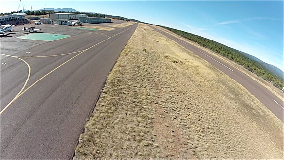
Yesterday’s LZ

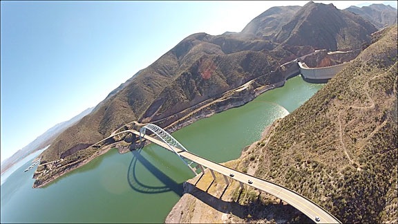
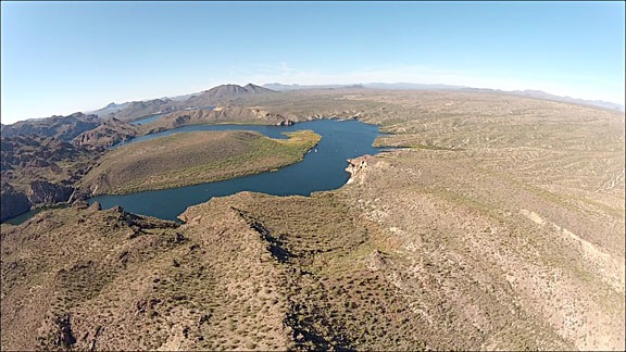
During the winter months, I operate an R44 in Arizona. I have a few regular clients who call me out to do survey or photo jobs out in the desert. They don’t always meet me at an airport or anywhere near any kind of pavement at all. It’s up to me, as pilot in command, to identify and land on a suitable spot.

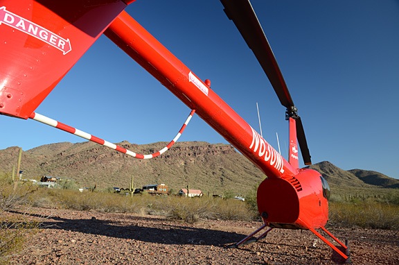
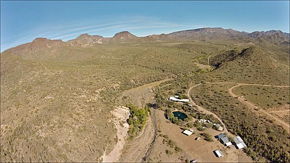
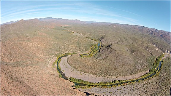
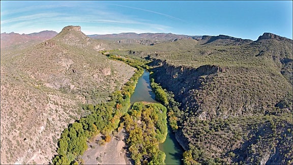
Like yesterday’s spot:

Desert Landing Zone

I posted an image like this to Twitter yesterday with the comment:

I love landing zones like this.

I got a rather funny response from @Instructor[redacted], someone I didn’t know, who said:

That’s a lot of loose rocks. How does the aircraft escape damage in that environment?

I don’t mean to poke fun at [redacted] — a guy that uses a headshot of himself wearing an aviation headset with boom mic as his profile picture, seeming to indicate that he’s a pilot — but come on now. Was he kidding?

And that was my response:

You’re kidding, right?

I don’t think he was. I can’t find his tweet in my @Mentions stream this morning; it was saved in my Twitter client on my cellphone, though. I assume it was deleted. Perhaps he realized belatedly how silly his question was. That’s why I won’t use his name here. I don’t want to embarrass him.

But I do want to clear up a few misconceptions about landing zones, for other new pilots and instructors who don’t yet have much off-airport landing zone experience.

Rocks Don’t Fly

I’ll admit it: my first response to @Instructor[redacted] was rather snarky, something like:

Rocks generally remain on the ground and don’t damage aircraft.

Maybe my Twitter client has a snarkiness filter that prevented the tweet from being sent. More likely, it was because I was near that LZ and my 3G connection sucked. In any case, as far as I can tell, my snarky response never went to Twitter.

Which is a good thing. Snarky doesn’t teach. It embarrasses and belittles. If it had been delivered, I would have felt compelled to apologize.

But the point is this: rocks don’t fly. They remain on the ground and other than possibly scratching up your skids or hooking a skid to create a dynamic rollover hazard on departure, they’re pretty much harmless.

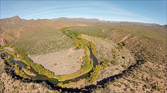
The LZ in this photo has nice small rocks. While there are some tiny ones — the kind that get caught in the tread of your shoes and are tracked inside the aircraft, forcing you to use the ShopVac back in the hangar to remove them — most are fist sized or smaller. None of these rocks are small or light enough to become airborne from downwash — at least not the downwash caused by a landing/hovering/departing R44. I can’t vouch for what a Huey might do to them, but I’m pretty sure that although movement is possible, flight is not.

What to Look for in an Off-Airport Landing Zone

When I tweeted that I loved landing zones like this, I wasn’t kidding. This landing zone has all the components I need to make a safe landing:

  • Level terrain. While almost no off airport terrain is completely level, this one comes pretty darn close. So I don’t have to deal with the risks and concerns of a slope landing — which I absolutely hate doing.
  • Smooth ground. Instructor[redacted] probably didn’t think the LZ was very smooth ground at all. But in the grand scheme of things, it is. I have seen (and landed on) ground pitted with holes and mounds of rock and scrub. This piece of land looks almost as if it had been graded smooth.
  • Little dust. Rocks may not be a flight hazard, but dust is. With a ton of light dust, brownout conditions can occur on landing. I blogged about that here. With any amount of dust, the hazard is to the aircraft’s rotor blades. Dust is extremely corrosive and simply takes the paint off the blades. The more dusty landings, the less paint on the blades. Eventually, the blades need to be repainted. Mine have been repainted twice in 1350 hours and might get painted this week again. (It’s in for its annual now and I’ll let the mechanic decide; I think it can go another 6 months.) I should point out that simply landing in a mildly dusty area is not going to “damage” the aircraft to the point that it’s not flyable. (Actually, there’s a lot to say about dust and the potential for aircraft damage; it’ll make a good topic for a future post.) This LZ was not dusty at all, partially because it had rained a few days before and partially because the area was not trafficked.
  • Good size. Although the area is surrounded by low bushes — mostly creosote — there’s enough clear area for my skids and tail rotor, as well as space on either side for pilot/passenger access.
  • No obstacles. Sure, on the way in I did have to thread my way between a few tall saguaro cacti and a decent-sized palo verde tree. But there were enough options on my approach and departure paths to make a safe go-around if I needed to abort the landing. Departure would require more altitude than on a runway/taxiway, but not enough to qualify as a max performance takeoff over obstacles. Indeed, I was able to make my takeoff run at about 10-15 feet AGL, pretty darn close to the suggested profile of the Height-Velocity diagram for my aircraft.
  • Photographic. Okay, so that’s not required for a good landing zone, but it is something that turns a good LZ into one I love. Why? So that when I share photos like the one above to help educate people about what helicopters can do, I can also show off how pretty the desert is. (And yes, how pretty my helicopter looks parked in it.)

So yes, I love this landing zone. Any helicopter pilot who has landed in worse places would.

In fact, I’d even go so far as to say that there’s nothing really wrong with this landing zone. It’s about as perfect as an unpaved off-airport landing zone could be. Hell, I’ve had on-airport landing zones that were less suitable than this.

Flight Instruction Failures?

And that brings me back to Instructor[redacted] with his headsetted face smiling out at Twitter users. Here’s a guy who appears to be a flight instructor, teaching other pilots how to fly. Yet he asked a very silly question that demonstrated his complete lack of knowledge and experience about landing zones.

And that bugs me.

People doing flight instruction should have better knowledge about what a helicopter can and can’t do. They should be able to identify what makes a suitable off-airport LZ.

I can only assume that this CFI was not properly trained. Perhaps his CFI lacked the same knowledge and understanding about off-airport LZs. Perhaps every CFI (and pilot) coming out of that flight school lacks this knowledge.

Does that mean these pilots won’t learn how to find and identify a suitable LZ until they get a job that requires them to do off-airport landings? If so, the flight school is doing a serious disservice to its students and their future employers. After all, when a pilot has the 1,000 hours of pilot-in-command flight time that most employers want, shouldn’t they already have the basic skills and experiences the employer should expect them to have? Isn’t landing off-airport one of those skills?

Maybe it’s because my flight school was based in Arizona and there are so many places to land out in the desert, but we were taught right from the start about off-airport landings. In fact, I can’t recall ever thinking that it was unusual to land somewhere other than at an airport or helipad.

After all, we’re talking about a helicopter here.

(I feel a major rant coming on, but I’ll stop right here, take a deep breath, and finish up instead.)

I hope Instructor[redacted] reads this. I hope that he understands that I’m not trying to poke fun at him or insult him. (After all, I did redact his name so he can remain anonymous.) I hope he learns from what I’ve written here.

But more important than that, I hope he talks to the Chief Flight Instructor at his school about their failure to properly educate him about off-airport LZs. I hope he helps them add some material to their curriculum to better educate their other students, pilots, and CFIs.

It’s a flight school’s job to churn out pilots — not guys and gals with pieces of paper that say they’re legal to fly. I sure do wish more flight schools would take that job seriously.