Instant Tilt-Shift Faking

Kind of takes the fun out of it.

A while back, I wrote a blog entry about my foray into the world of tilt-shift photography. Although I have no interest in investing cold, hard cash in the hardware to do real tilt-shift photography, I learned how to fake in in Photoshop by reading “Tilt Shift Photography in Photoshop Tutorial.” I was pleased with the results and found the whole thing fun and rather addictive.

Today, I stumbled upon a site that fully automates the entire process: TiltShiftMaker. You upload a photo and it applies the unfocus mask, which you can adjust. You toggle a check box to determine whether you want colors enhanced. It then spits out a photo with the effect applied, as shown below. Any idiot can do it. Even me.

TiltShiftMaker in Action

The photo I started with was an aerial shot of the Grand Coulee Dam, taken this summer when my husband and I flew down the Columbia River. There’s nothing special about this shot; I didn’t even bother to spruce it up for this experiment. So the colors are a bit washed out and the framing is far from perfect:

Grand Coulee Dam

After processing with TiltShiftMaker’s default settings, it looks like this:

Tilt-Shift Grand Coulee Dam

For a quick and dirty tilt-shift, it ain’t bad. I tried to manually modify the original image using Photoshop and my results weren’t significantly better. Sure, I had a lot more control over the amount of blur, the size of the in-focus area, and the amount of saturation to give it those punched-up colors, but when I compared my final product to the automatically generated one, I had to admit that the automatically generated one looked more like a photography of a model scene.

But it certainly does take the fun out of playing around with this technique.

To me, the real challenge of faking tilt-shift photos comes from trying to take photos that would work well as fake tilt-shift miniatures. Aerial photos are great for this, especially if they include buildings and/or cars. They can’t be straight-down images, though. They need to be shot at an angle, so there’s an obvious reason for one portion of the photo to be in focus while the other parts are not.

Anyway, if you’re interested in this sort of thing, give TiltShiftMaker try.

Photos from Our Flight to San Diego

The view from above.

In November, Mike and I took my helicopter to the San Diego area for business. The flights to and from San Diego were over some of the most interesting — and boring — desert terrain out there.

Our route to San Diego from Wickenburg (E25) took us southwest, skirting around the restricted area north of Yuma, where we landed for fuel. (Fuel there was $1.20/gallon cheaper than at my home base.) Then almost due west along I-8, over the Glamis Dunes and Imperial Valley, which lies below sea level. Finally, a climb over some mountains and a descent down to Gillespie Field (SEE).

On the return flight, we took a different route. We flew east along I-8, then northeast to the northern tip of the Salton Sea to Chiriaco Summit and then along I-10 to Blythe, where we refueled. (The fat guy is gone.) From there, we overflew Quartzsite before making a bee-line for Wickenburg.

You can see the approximate routes below; click the map for a larger view with readable labels.

Route of Flights

Mike’s got his private pilot certificate and 100 hours of flight time in helicopters, so he’s legal (per my insurance company) to fly passengers. So he did most of the flying. I had my door off for the Yuma to El Cajon part of the flight and took photos — mostly over the Glamis dunes. It was nice to be a passenger for a change — to be able to use my camera without left-handed contortions. I also had the POV.1 video going for part of the flight, although the sound crapped out part of the way.

Anyway, here are a few of the photos I took on the flight. You can find more of my aerial photos — as well as larger versions of these — in my photo gallery.

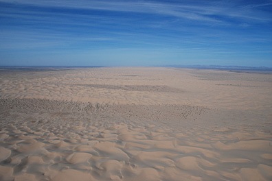
Glamis Sand DunesGlamis Sand Dunes

Formally known as the Algodones Dunes or the Imperial Sand Dunes Recreation Area, the Glamis Dunes is a huge series of sand dunes west of the Colorado River, northwest of Yuma, AZ in California. The dune field stretches 45 miles north to south and 6 miles east to West. This photo shows only a portion of the dunes, looking north from the I-8 area. The dunes are extremely popular for off-road vehicles; this photo was taken on a relatively quiet Friday morning.

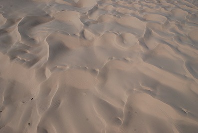
Sand DunesSand Dunes

Here’s a closeup shot of the Algodones Dunes from the air. This shot was taken from about 500 feet above the ground, over I-8, just west of the Arizona-California border.

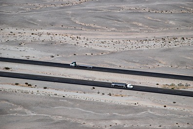
Desert FreewayDesert Freeway

The folks back east probably have no concept of the long distances of nothingness on a freeway that cuts through the desert. This shot of two tractor trailer trucks passing each other in the barren wasteland of the Imperial valley’s southern extremities might give them an idea.

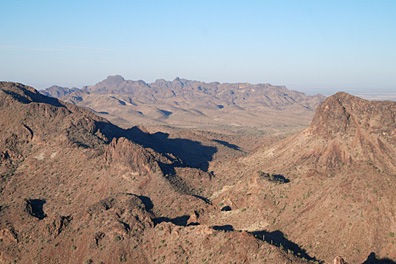
Desert MountainsDesert Mountains

The mountains just seem to go on forever in this aerial shot of mountains in southwest Arizona, not far from Quartzsite. Lake afternoon light casts long shadows.

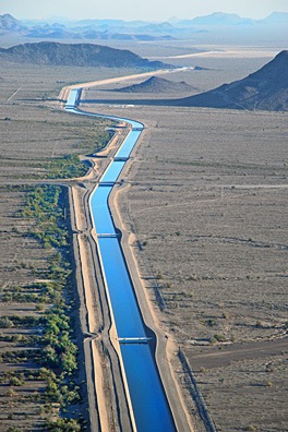
CAP CanalCAP Canal

The Central Arizona Project (CAP) snakes its way through the Arizona desert, bringing water from the Colorado River and its lakes to Phoenix and its suburbs. This shot was taken just north of Hope, AZ on our return flight to Wickenburg.

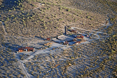
Forepaugh RanchForepaugh Ranch

This ranch is nestled at the base of two hills in Forepaugh, AZ, out of sight from the main road (Route 60) only a mile or so away. It reminds me of an earlier day of ranching, when remote ranches were self-sufficient homes on the range.

Our Foray into Aerial Photography

A side note to my Digital vs. Film blog Post.

[I’d originally written this as part of my post titled “Digital vs. Film,” but pulled it out in an effort to shorten-up that post and keep it more focused on the topic. You might find it interesting if you think you might want to try your hand at commercial aerial photography.]

Pentax 67 CameraI think it was in 2003 that Mike and I decided to try our hands at aerial photography. I bought a book about it (as I usually do, when I want to get a jump start on learning something) and the book said the best kind of camera for this kind of work was a Pentax 67. The camera was huge and heavy and took 126 film, which could not be processed locally. But that didn’t stop me from plunking down $1,500 for a used one. You gotta spend money to make money, right?

The Pentax 67 turned out to be a huge mistake. Although the camera had an internal meter, it did not have automatic exposure. So each exposure had to be set using its meter before snapping an image. Since I was doing the flying, Mike did the photography. He’s set the exposure on the first shot and use the same exposure for the entire shoot. You might think that would work, but it doesn’t. As the helicopter approaches the target from different angles, the sun hits the target differently. Some images were under exposed while others were overexposed. 2/3 of the images were not usable. And because we didn’t know this until nearly a week after the shoot — after the film had come back from the out-of-town processors — we didn’t know until then how bad the results were. We did two reshoots — at my cost — before I decided that camera was not for us. I sold it for $1,000, swallowing a $500 loss after owning it for about a year. Ouch.

I bought a Canon G5 camera. This was a regular digital camera that looked a bit like an SLR. But although it had all kinds of automatic, program, and manual settings, it did not have interchangeable lenses. It did offer 5 megapixel resolution, however, and that was a huge number in those days. We tried our hand at aerial photography with that. The results were better — at least the exposures were good and we could see them immediately — but my photographer was having trouble properly framing the subjects and our clients evidently had different ideas of what their property looked like from the air. I decided to give up on providing photography services. If a client wanted aerial photography, I’d be perfectly happy to do the flying for them, but they’d have to come up with their own photographer.

I’ve since purchased a Nikon D80 with multiple lenses. We’re playing with aerial photography again, but I’m still not interested in taking on any commercial assignments with either Mike or me snapping the pictures.

You can see some of our aerial photography efforts (with more to come) in the Flying M Photos gallery.

Lake Powell Photos win Photo Contest

Photographer Mike Reyfman takes first place in “Abstracts” category.

Lake Powell Abstract by Mike ReyfmanI’m extremely pleased to spread the news that one of Flying M Air’s best clients, Mike Reyfman, has won an award in the Pilsner Urquell International Photography Awards. His series of photos of the sandstone canyons uplake from Rainbow Bridge has taken first place in the “Abstracts” category. Here’s one of Mike’s photos, reproduced with his permission. You can see them all here.

I’d like to add two things here.

First, whenever a photographer who flies with me wins an honor or publishes a photo taken from my helicopter, I feel a great deal of pride. Although I didn’t frame the image and snap the photo, I do feel as if I’m part of the photographer’s “equipment.” My small part in any great photo makes me feel good.

Second, Mike offers photo excursions all over world. Although most of his clientele are from Russia (where Mike is originally from), I’m pretty sure he’ll take anyone who can speak either Russian or English. Lake Powell is only one of the destinations he comes to regularly; he’s also taken groups to Iceland, the Pacific Northwest, New Zealand, and lots of other places I wish I could go. Aerial work is only a small part of some of the trips he offers. You can learn more and see Mike’s gallery of photos from his travels on his Web site.

And thanks, Mike, for letting me know about your award! Congratulations!

Aerial Photos by Passengers

Some great shots from my left seat.

One of the things that’s so frustrating to me as a pilot and photographer is that I can’t do both activities at the same time. You see, when I fly, my hands are full. I can’t let go of the cyclic to frame a shot — the helicopter would begin aerobatic maneuvers that would make me sick (or worse). So although I get to see some pretty amazing things from the air, I rarely get a chance to take a decent picture of any of it.

So I was tickled pink today when I went through my Google Alerts and found that photographer Ann Torrence had mentioned me in two recent blog posts. In each post, she shared a photo she’d taken from the left seat of my helicopter when we flew from Page to Marble Canyon and back on August 16.

The first post shows a great — and very unusual — shot of Horseshoe Bend. Everyone takes the same picture of this place, primarily because they all take it from the same viewpoint, on the east side of the cliff. But when you’re in a helicopter, above the terrain, you can shoot from anywhere. And as I circled this outrageous bend in the Colorado River, Ann shot from the northwest. As she said, it’s the first time she’d seen it from that angle. And it’s the first time I’ve seen a picture taken from there.

The second post shows the two Navajo Bridges — historic and newer — over Marble Canyon. Marble Canyon is the extreme starting point of the Grand Canyon. It’s a narrow, deep gorge cut through relatively flat rock plateau. As I used to tell my Grand Canyon passengers, it was named by John Wesley Powell, one of the original explorers of the Colorado River through the Grand Canyon, who thought the walls of the canyon were made of marble. (They’re not.) From the air, it looks like a crack. Ann’s shot of the bridges is pretty good, although I did have a passenger take a nice shot for me, years ago, from the other side of the bridge looking downstream. Trouble is, the bridge is in restricted airspace, so you can’t just fly around it. You can only fly past on landing or takeoff from Marble Canyon’s little airport.

I should point out here that there are other images taken from my helicopter in the Page, AZ area on the Web. Photographer Mike Reyfman has a number of galleries of Lake Powell and Monument Valley. And at least one photo taken from my aircraft in this area has wound up in a Cessna magazine ad.

Anyway, I’m up in Page, AZ, offering photo flights in the area through American Aviation. I’ll be here through the end of September and possibly into October. If you’re in the area and want to see a different perspective for your photos, give American a call at 928/608-1060. They’ll set you up for a photo flight you’ll never forget. And maybe — just maybe — you’ll get some photos as good as Ann’s and Mike’s.