Helicopter Minimum Altitudes

I’m working on a much longer blog post, with photos, about my recently completed autumn vacation, but I thought I’d put this shorter post out because it’s quick and on my mind.

It started with someone on Twitter sharing a video from inside the cockpit of a helicopter flying low and fast over a forest road. There were no cars on the road and no poles or wires. It was an exciting little flight that reminded me of the kind of canyon flying I used to do in some very familiar, remote areas of Arizona. See for yourself.

Helicopter video screenshot.
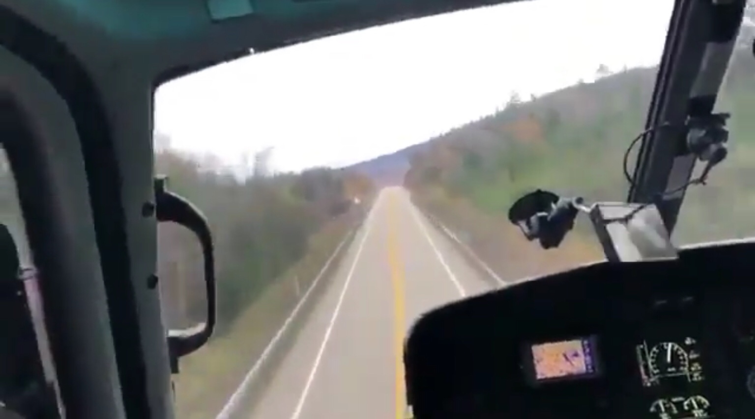
Here’s a screenshot from the video in question.

What followed was a bunch of comments, including some from a few people too lazy to look up the regulations who claimed that flying like that was illegal. When I pointed out that it was not illegal in the US, a particularly lazy, uninformed idiot quoted my tweet with a portion of the FARs in an attempt to prove me wrong. He didn’t. All he proved is that like so many people these days, he’s only capable of reading until he gets confirmation of what he wants the truth to be. The rest doesn’t matter.

Here’s the entire FAA regulation covering minimum flight altitudes in the US:

§91.119   Minimum safe altitudes: General.

Except when necessary for takeoff or landing, no person may operate an aircraft below the following altitudes:

(a) Anywhere. An altitude allowing, if a power unit fails, an emergency landing without undue hazard to persons or property on the surface.

(b) Over congested areas. Over any congested area of a city, town, or settlement, or over any open air assembly of persons, an altitude of 1,000 feet above the highest obstacle within a horizontal radius of 2,000 feet of the aircraft.

(c) Over other than congested areas. An altitude of 500 feet above the surface, except over open water or sparsely populated areas. In those cases, the aircraft may not be operated closer than 500 feet to any person, vessel, vehicle, or structure.

(d) Helicopters, powered parachutes, and weight-shift-control aircraft. If the operation is conducted without hazard to persons or property on the surface—

(1) A helicopter may be operated at less than the minimums prescribed in paragraph (b) or (c) of this section, provided each person operating the helicopter complies with any routes or altitudes specifically prescribed for helicopters by the FAA; and

(2) A powered parachute or weight-shift-control aircraft may be operated at less than the minimums prescribed in paragraph (c) of this section.

[Doc. No. 18334, 54 FR 34294, Aug. 18, 1989, as amended by Amdt. 91-311, 75 FR 5223, Feb. 1, 2010]

Did you read paragraph (d) and paragraph (1) right beneath it? I did, but the know-nothing twit pretending to be an expert on Twitter didn’t. It basically says that the paragraphs he quoted (paragraphs (b) and (c) above) don’t apply to helicopters.

I distinctly remember this FAR coming up during my primary training back in the late 1990s. It basically gives helicopter pilots permission to fly at any altitude they need or want to, given that “if a power unit fails, an emergency landing without undue hazard to persons or property on the surface.”

Take a look at the video. It looks to me as if the pilot is 50-100 feet off the ground. He’s moving at a good clip — at least 60 knots. (I tried to read the airspeed indicator but couldn’t.) With that altitude and airspeed combination, he’s not operating in the shaded area of the height/velocity diagram (or “deadman’s curve“). That means that a safe emergency landing is possible. And with nice smooth pavement beneath him, there’s plenty of suitable space for a landing if it was necessary. So it’s not in violation of paragraph (a) either.

Watch My Helicopter Videos on YouTube

Time for a shameless plug…

Flying M Air Logo

If you like helicopters, you’ll love the FlyingMAir YouTube Channel. Check it out for everything from time-lapse annual inspections to cockpit POV autorotation practice to a flight home from a taco dinner at a friend’s house — and more.

Lots of people don’t get this. They assume the altitude rules apply equally to all aircraft. But they don’t. This makes it pretty clear. Trouble is, there are too many self-important assholes out there — especially on Twitter — who share inaccurate or incomplete information as fact — and too many lazy people willing to believe them without doing their own homework.

If you want to read more about this topic, here’s an old, long, rambling post I wrote about an experience related to this years ago.

Oh, and by the way, this post is about whether the flight is legal in the US. I won’t make any comments about whether it’s safe or whether the pilot is using good judgement. That’s a whole different topic.

Making Art From Nature

Taking jewelry making to the next level.

I’m feeling rather tickled right now. I just finished this sterling silver and Dorset Marble pendant.

If you follow this blog, you might be rolling your eyes right now. Big deal, you’re probably saying. Another pendant.

But this one is different.

You see, this is a stone I found on my visit to Dorset Quarry in Vermont earlier this month. I figure that an old marble quarry might have a few small pieces of marble lying around and I was right. I picked up about ten thin pieces to take home with me.

Then, yesterday, I took three of those pieces into my shop and used my CabKing to shape and polish them into cabochons.

And then today I picked the largest of the three marble cabs and wrapped it in sterling silver to make this pendant.

This photo gives you an idea of the stages of the creation process, from dirty stone to finished pendant:

And that’s why I’m tickled. I took something I found in the dirt on the other side of the country and turned it into a beautiful piece of jewelry.

Autumn 2018 Trip Postcards: Okemo Mountain Resort

Friday was a glorious day in Vermont and, after making a quick trip to Rutland with one of my hosts to run some errands, I headed out to Ludlow for a drive up Ludlow Mountain in the Okemo Mountain Ski Resort. My destination was a fire tower at the top of the mountain that would require a drive to a parking area near the top and a 1/2 mile uphill hike.

Fortunately, the road was paved and in decent condition — I’ve been driving my brother’s Maserati this trip and it does not like rough roads or potholes — so the trip to the top, which crossed several of Okemo’s ski runs and wound through the forest, was pleasant and smooth. I backed into a parking spot among about six other cars in a gravel lot. Then Penny and I continued the trip on foot though a half-open gate up a relatively steep gravel road running through dense forest. The sound of trickling water was present, coming from one side of the road or the other all along the way.

My host had told me that I’d have to walk to the ski lift to see the tower in order to find it. While it’s true that the tower wasn’t visible from the road, I did spot a small wooden sign pointing to a very narrow trail into the woods. The tower was just another 1/10 mile away. We took the path.

Although it was a bright, sunny day, the woods were dark and cool. The path was muddy in some places, with large boulders that kept me out of the mud as I climbed over them. Another sign at a fork in the trail directed me to the left. Moments later, we were at the bast of a small, five-story fire tower with spindly legs and a tiny wooden structure on top.

Fire tower atop Ludlow Mountain.

Here’s a view of the fire tower from its base. I shot this after my descent; three hikers are on their way up here.

The steps were steep and I had to carry Penny. (Another benefit of having a small dog.) I paused briefly for a look at each landing. The view kept getting better and better. The steps got steeper and narrower at each level. Soon we were through the trap door and standing in the tiny room at the top.

Panorama from the tower looking east.

Here’s a panorama looking east from the fire tower.

A view of Ludlow from the fire tower.

I could also see Ludlow far down in the valley.

After about fifteen minutes of drinking in the view, I picked up Penny again and carefully made my way back down. We met some other hikers as we made our way back down the trail, including a couple who had stopped upon seeing a garter snake alongside the trail. He pointed it out to me and I got a good look as it slipped away into the brush. His wife was apparently terrified and I heard her whining to him about it even after I’d left them behind on the trail.

Back out on the sunny gravel road, we hiked up to the ski lift. As my host had said, I could see the fire tower from there.

Fire tower in the forest.

The view of the fire tower from near one of the ski lifts.

I also got some great views looking down the mountain along the parked chairs of the lift.

Looking down the ski lift.

A view down a ski lift at the top of Okemo Mountain Resort.

On the way back to the car, I poked around in the forest a bit. This time of year I’m always looking for chanterelle mushrooms. Although I didn’t find any there, I did find other mushrooms growing out of the forest floor.

Forest mushroom.

The obligatory mushroom photo.

We spent a little more than an hour atop the mountain. then it was back in the car for the drive down and a lote lunch.

Autumn 2018 Trip Postcards: Dorset Quarry

While scanning Google Maps for some day trip destinations this morning, I stumbled upon Dorset Quarry. Dating from 1785, it’s the first marble quarry in the area and the oldest quarry in the United States.

A popular swimming hole in the summer, it was pretty quiet on a partly cloudy autumn day. Here are a few photos.

Dorset Quarry.

A view of Dorset Quarry from the north side.

Cut stones.

Piles of very large stones stacked along the north side of the quarry.

Waterfall, creek, and bridge.

The quarry’s large pool is fed by a small creek that cascades out of the forest.

Stones and quarry pool.

Can you see Penny running toward me in this photo shot on the south side of the quarry?

Autumn 2018 Trip Postcards: An ATV Ride in the Forest

I’m in Vermont this week, spending some time with some very old friends. Today, we mounted up on their ATVs and headed out into the national forest near their home on some of the roughest ATV trails I’d ever been on. Here are a few photos.

Penny on the quad.

Penny came along, of course. Although she normally stands on the fuel tank of my ATV when we ride it at home to do chores, this ATV had a smaller tank and the roads were a lot bumpier. So I put her in a milk crate fastened to the front of the ATV. Here we are at the start of one of the trails.

Foundations in the woods.

It’s hard to see in this photo, but there’s a stone foundation of an old 1800s farmhouse here. This was one of many completely cleared farm sites 200 years ago.

Pond-side campsite.

This campsite is my friends’ sons’ favorite.

Wallingford Pond.

Wallingford Pond is more of a lake than a pond. As you can see, the weather wasn’t exactly perfect for fall foliage viewing.

Dam in the forest.

Another narrow trail through the woods took us to this old dam which still provides a farm several miles away with water.

View from the cabin.

Our last stop was an off-the-grid cabin high in the mountains. The views are supposed to be amazing but today the clouds lifted just enough to give me an idea of what I was missing.