I learn the basics of drying cherries with a helicopter.
Before I go into some details of the cherry drying training I received last Sunday and Monday, I need to issue a warning to pilots: This article is not intended to substitute for any one-on-one training with a qualified and experienced cherry drying pilot. It’s just a summary of my training experience. As such, it’s likely to give you a rough idea of what kind of flying a cherry drying pilot might have to do. Actual cherry drying work should not be attempted without sufficient specialized training.
And no, my lawyer didn’t make me say that. Common sense did.
Too many people are willing to attempt difficult flying jobs without the proper training or experience. It’s generally agreed that a cherry drying pilot should have at least 500-800 hours of helicopter flight time — if not more. I believe that at least 300 hours of that time should be in type so the pilot has a good feel for how his particular aircraft flies. The more logged helicopter time, the better. Cherry drying should not be considered a time-building job. (Neither should aerial photography, but I won’t go there right now.) Don’t try to con your way into this kind of work unprepared. Don’t become a statistic.
And remember, I cannot guarantee the accuracy of anything here. This article summarizes my training experience — not my actual cherry drying experience. Don’t read this and think you know everything about it. I don’t, so there’s no way this article can explain it all to you.
My Teacher
I was fortunate enough to get an offer of training from a Portland, OR based pilot named Dave who had spent at least six seasons drying cherries in R44 helicopters. He’s friends with my cherry drying partner, Erik, and was one of two pilots who prepared Erik for his first season two years ago. Dave did this for me (and Erik, for that matter) as a favor, offering to tell and show me as much as he could to prepare me for the work. He was not interested in receiving payment for his time or making any kind of logbook signoff or endorsement. In other words, he was doing it as a friend and would not take responsibility in any way if I had problems while working.
I found our arrangement satisfactory. I also considered myself lucky to be able to spend time, both on the ground and in the air, with him.
One more thing: Please don’t try to look up Dave and get him to train you. For one thing, you won’t find him. His real name isn’t Dave. For another, he did this for me as a favor. I don’t think he’d like it if 50 helicopter pilots he didn’t know tracked him down and asked for the same favor. If you want training, make your own contacts among your own friends. Please don’t think this article is an open invitation to approach my contacts or friends. Doing so will only force me to stop sharing experiences like these with blog readers.
Ground School
We started off with coverage of some topics in a discussion over dinner. Dave was joined by George (not his real name), another experienced cherry drying pilot, and I was joined by Louis, the pilot who accompanied me on my flight from Wickenburg to Seattle. Although the conversation wandered quite a bit, Dave was pretty good at getting it back to the topic of cherry drying.
The first thing he told us was that it was the most difficult and dangerous work he had ever done. I got the feeling that it was why he didn’t do it anymore.
He pulled out a notepad where he’d listed a bunch of discussion points. I took notes.
- Altitude and speed. Varies depending on grower preference, age of trees, and type of cherry, but generally 10 to 15 feet off the treetops moving at 4 to 6 knots. I’d have to eyeball the altitude and monitor the speed with my GPS. The whole time, I’d have my head out the window, monitoring my downwash to see what it was doing.
- Wires. There are wires at all heights, from simple lines at treetop level to high tension powerlines overhead. Wires criss-cross the orchards and can be anywhere. I should drive or walk the orchard before my first flight over them. Dave drew several diagrams showing the kinds of wires, where they might be, and how I might fly the field to avoid them.
- Wind. It’s not uncommon to be flying in wind up to 30 knots. More than that and the cherries dry themselves. Because flight is up and down the rows, I might be flying with strong crosswinds or tail winds. At slow speeds, this could easily become a pedal dance.
- High density altitude. The fields I’ll be drying are at 1,200 to 2,000 feet. Add 95°F to pump up the density altitude. Although this shouldn’t be an issue for my R44 Raven II with just one person on board, it could be an issue in high winds if I bring along a passenger. (I don’t plan on doing that.) It could also be an issue for a lesser-powered helicopter, like an older Raven or Astro.
- Fans. Some fields have fans for drying cherries. These aren’t very effective, but they do move a lot of air. Dave advised me never to enter a field when one of these fans were going. “Tell the grower to turn them off,” he advised me.
- Bird cannons. Some fields also have cannons that send out a loud burst of compressed air to scare birds away. The cannons are not dangerous, but they are loud and sound like backfires. I should expect to be startled. (Erik later added that some of these cannons have motion sensors that the helicopter will set off.)
- People in orchard. While I’m drying, there may be people below me, in the trees, working. They shouldn’t be a hazard, but they’ll be there.
- Sprinklers. Some of the orchards use overhead watering systems for the early part of the season. The sprinkler heads stretch up higher than the tree tops. (I actually saw these the next day, when I went to Quincy. They’re on poles about two feet taller than the trees.)
- Other obstructions. Buildings and pump houses, which could be in the fields, almost always have wires going to them. Some fields are surrounded by tall trees planted as wind blocks. It’s necessary to dry the cherry trees that are adjacent to them. Some fields are planted on steep slopes; it’s best to start at the top and work your way down, keeping the main rotor blades in mind.
- Cherry types. Some cherries can withstand more violent winds than others. Bing, for example, is very sturdy while Rainier cherries bruise easily. You have to know what kind of tree you’re flying over and adjust the velocity of the downwash accordingly.
He gave me some other advice that should be a no-brainer — for example, always know where your tail rotor is. This is especially important with an R44, since its tail is so damn long. Knowing what’s behind the helicopter will determine how I make my turns at the end of a row.
He recommended that if I got into trouble and needed to get out of my current position in flight, I should always try to bail out to the right to use less power. He was very concerned about density altitude. I admit that I’m not quite as concerned, since I almost always fly at higher density altitudes than the cherry drying fields and I’m usually heavy when I do it. (Hell, I live in a higher density altitude than those fields!) I put nearly 700 hours on my Raven II and have a very good idea on how it handles in many situations — which is why I recommend at least 300 hours in type for any cherry drying pilot.
Considering that I’d be operating in the shaded area of the height-velocity diagram for the entire flight, we also talked about what to do if I had a chip light or a stuck valve or a dead mag. His advice was basically to forget what the operating manual said about chip lights and most emergency lights — just land immediately, wherever there was space near the field. If a power loss meant I was going to crash, he recommended aiming for a spot between the trees and pulling the cyclic back a little to land tail first. He seemed to think that the crumpling of the tail would help cushion the impact. Any crash in an orchard would destroy the helicopter; my main goal should be to walk away from it.
Practice Flight
There weren’t any cherry trees in the area, but Dave knew a spot on the Columbia River which was undeveloped and had trees similar to cherry trees in branch strength and consistency. We took off from Troutdale Airport and headed right over the river, eastbound. Dave did the radio calls — Troutdale is towered — and I followed his directions to Reed Island.
I had my POV.1 video camera mounted on the helicopter’s nose for the flight and I turned it on not long after takeoff. I recorded the entire training flight so I could review it later. Here are the first 4+ minutes, which should give you an idea of how low I had to fly over the treetops. The cockpit voices you hear are mine and Dave’s; you can also hear the tower talking mostly to other aircraft.
[Video WAS here but the host, Viddler, has decided to end free hosting of videos and I can no longer access it. I’ll try to find a copy of it on my hard disk, but the chances of that happening are VERY slim. After all, it was done back in 2008. – Maria 5/26/14]
I had my door off for the flight, since Dave recommended that I keep monitoring what was going on beneath and behind me. In fact, in the video, you’ll hear Dave remind me once or twice to look outside. Later in the full-length video, we discuss flying slightly sideways, perhaps pointing the nose at the 1 o’clock position, so I could see what was below and behind me without having to twist my neck so far. If the wind is cooperative while I’m flying, that’s exactly what I plan to do.
In this video, you really don’t see the trees moving at all. That’s because the camera is pointing out the front and the downwash hasn’t reached those trees yet. But beneath and behind us, the trees were going wild — “hammered,” as Dave said. The downwash was even getting between the trees, giving every branch a good shake. I’d have to adjust altitude based on the type of cherry I was drying so I didn’t bruise the fruit.
The speed indicator was my GPS. The airspeed indicator is pretty useless at speeds less than 10 knots. But the GPS clearly showed how fast I was going, in tenths of a knot. Dave seemed to think that 5 knots was a good speed. (Later, on discussion with my main contact for the growers, I was told they preferred 10 to 15 knots. Again, I think it will vary by grower.)
I had no trouble keeping the altitude he wanted, although I did vary my speed as we talked. It’s the old chew gum and walk at the same time problem. I can do precision flying or I can talk, but when I talk, I lose precision in my flying. I kept noticing that my speed was popping up to about 7 knots and I kept slowing down. Sometimes I fixed the problem before he noticed but sometimes I didn’t. I’m hoping that without a companion to talk to, I won’t have to worry about distractions. (I’m also hoping that this kind of work becomes so second nature that I can listen to music or podcasts as I fly.)
Later on in the flight, he showed me some techniques for drying trees that were growing close to wires or taller trees. This basically means moving up rather quickly — maybe at 10-15 knots? — on a tree and then pulling back the cyclic to slow/stop and climb slightly. This directed the downwash forward. It was a lot like doing the flare in a quick stop. It’s important to keep high enough so the tail rotor stays out of the trees behind you, and high or low enough so that your main rotor blades stay out of any wires or tall trees ahead of you. I didn’t include this in the video because you simply can’t see the effect of the maneuver because of camera placement.
We also discussed how to use the wind in your favor when drying trees at the edge of an orchard. If you stay upwind of the trees, the wind will blow the downwash to the trees. Pretty simple stuff. Of course since you can fly in any direction, you can play with this technique to get at most trees in windy conditions — provided you can maintain control of the helicopter at slow speeds in those winds.
We played around with a few other techniques, flying up and down the low trees alongside the river for nearly an hour. When he felt as if he’d drained himself of advice and seemed comfortable with my flying abilities, we decided to call it quits for the day.
I Learned a Lot
I learned a lot about the job ahead of me. I can’t thank Dave enough for taking the time to share his experience with me. Thanks to him, there will be a lot fewer surprises in store for me when I get to work in early June.

 This has evidently been circulating around the Web. I received it with a note this morning from my friend, Tom, and thought I’d share it here:
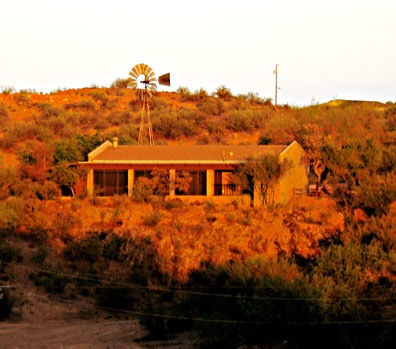 The house was one of the very first built in our area. It’s a one-story structure with just two bedrooms and two baths, perched on a rocky, lichen-covered outcropping. At the base of the rocks was a densely vegetated flood zone, filled with local trees and bushes slightly higher than the level of Cemetery Wash, which also flows through our property. Up at house level were irrigated trees so mature that they blended in perfectly with the home. The house seemed to be part of the landscape. And in the morning, when the first light of day hit it from the east, it glowed red, as shown in this July 2007 photo.
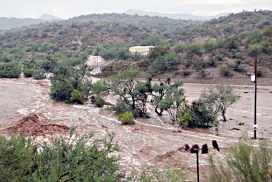 Monsoon season came and the first heavy rain brought a massive flash flood. The sand berms were no match for the power of flowing water. The water coming down the wash was no longer held back by the dense vegetation that had grown below the house. The wash changed its course, flooding the undeveloped “pasture” and cutting across the bottom of our access road. The rushing water completely flooded the sandy area in our part of the flood plain and, for the first time ever, our entire fence was washed away.
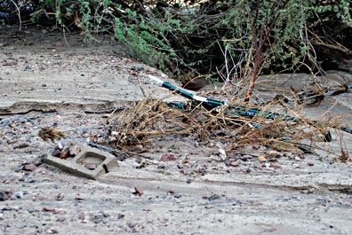 When the water subsided, parts of our neighbor’s new fence were tangled across the access road to our neighbor’s house. Cinderblocks from their corral area littered our lower horse corral. Their “pasture” was filled with sand. Lucky they hadn’t set up the irrigation yet; it would have been destroyed.
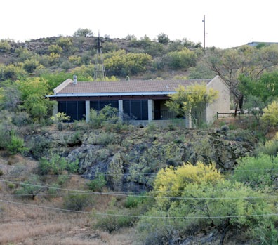 While I was out one day, workers took the head off the windmill and left it on the ground, at the base of one of the dead trees.
 Our course took us quite close to
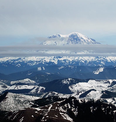 I punched Boeing Field (BFI) into the GPS and we got back on course. We passed far to the west of Mount Rainier, then headed inbound. Louis had done much of his training at Boeing Field, which is squeezed into a tight area north of Seattle-Tacoma International (SEA) and Renton (RNT), I so I turned all navigation and communication over to him.