Another trip up the mountain.
On Sunday, Mike’s cousin and his girlfriend were in town from Seattle. They were bummed out because of the weather — it was rainy with low clouds — but we desert-dwellers were thrilled. We’ve had quite a bit of rain this winter and the desert is lush and green — or as lush as a desert can be, anyway. Every time it rains, we think about how much greener the grass between the cacti will get and how incredible the spring flowers will be in another month or so.
They wanted to do something and we wanted to do something outdoors. So we geared up with hiking boots and jackets and water bottles, packed ourselves into my Jeep with Jack the Dog, and drove out to the Vulture Peak Trailhead, which is about 7 or 8 road miles from our house.
Vulture Peak is the tallest mountain in Wickenburg and, indeed, the tallest peak in the immediate vicinity. It’s the remains of a volcano and has an odd shape that gives it a completely different look depending on what direction you’re viewing it from. From our house, it looks like a tall knob. But from the main trailhead parking lot, it looks like a wide rocky butte.
It was still raining when we drove through the main trailhead parking lot and continued on the 4WD road to the trailhead at the foot of the mountain. To get there, we had to drive down a very steep, very eroded embankment. I’m too cowardly to drive down places like that, so I climbed out and Mike climbed in behind the wheel. He threw it into 4 low and crawled down the hill, letting one wheel and then another hang in the air while the rest of the wheels did all the work. At the bottom, I climbed back in behind the wheel and we continued on the way.

My Jeep, Packed to the Gills.
The rain — a steady drizzle — let up when we reached the second trailhead. I parked and we tumbled out. My Jeep is a 4-seat Wrangler and it was packed to the gills with the four of us and a 55-lb dog. Good thing I had the doors and back windows off to give us breathing room.
Above us, the clouds were moving briskly from south to north. It was about 10 AM and the sun was trying hard to break through the low clouds. It looked promising. We started up the trail toward the saddle.
I’ve written extensively about Vulture Peak for wickenburg-az.com. That piece, originally written in 1999, is accompanied by the tiny photos the Web site supported back then. One of my goals on this trip was to take some better photos to share on the site, and possibly include in my Photo Gallery. So I had my Nikon D80 with me, as well as two lenses: my 16-85mm zoom and my 10.5mm fisheye.
My companions quickly got a lead on me up the steep trail. I’m miserably out of shape these days, but I never did do well on uphill climbs. Sure, I can do downhill on a trail all day long without lagging, but point me up a hill and be prepared to wait. I’ll get there — eventually — but I need a lot of rest stops along the way.

A view from the start of my hike.
I took the opportunity to shoot some photos as I hiked. The brightening desert was all around me and, as I walked, the sun poked out and cast its bright, warm light here and there. And then there was the novelty of wet rocks and drops of water on the cacti. And puddles. Do you know how seldom we see puddles out in the desert? That day, they were all over the place.
Soon I was alone on the trail, huffing and puffing as I hiked upwards. The trail is probably rated as intermediate difficulty from the second trailhead, where we started, to the saddle. (It’s probably rated easy from the first trailhead to the second; a nice 1-1/2 mile stroll on a narrow pathway through the desert.) It’s not a long walk, but it’s steep. After an initially easy straight climb, it zig-zags up the mountain on a series of narrow switchbacks neatly carved into the terrain.

On Vulture Peak Trail.
I was upset to see that some hikers had inconsiderately cut corners, creating “shortcuts” of crumbling rock trails. I was also bothered by the sight of uprooted penstemon — one of the few wildflowers already in bloom — tossed aside on the trail. Who would tear wildflowers out by the root? And why? Apparently there are people out there with far less appreciation for the desert than we have. Perhaps they should have stayed home in front of their TVs and video games and left the plant life alone to grow and multiply.
Within an hour, I was near the saddle where the trail opens up to a wide area offering views in two directions. On one side, to the north, is the rocky peak of the mountain. On the other side, to the south, is a series of secondary peaks that reach up to the sky with jagged, tooth-like edges. I fully expected to be alone there, too. The summit was a short but difficult steep climb away and I assumed Mike and his companions would have made the climb by then. But they were there, waiting for me. Our out-of-town visitors had been spooked by the hand-over-hand portion of the climb and had decided the saddle was far enough up the mountain. That’s unfortunate because the view from up there is 360° and, on such a clear, crisp day, would have been breathtaking.

View from near the top of the Vulture Peak trail.
I rested up, snapping photos with my camera. I soon realized that exposures would be a problem and used bracketing to ensure I’d get at least one shot out of three that was properly exposed. (What did we do before we had digital cameras? Waste film? Waste time in a darkroom? Waste photo paper on crappy shots half the time?)
We hiked around a bit in the saddle area, then went to explore the areas around the secondary peaks. I’d never hiked up that way. It wasn’t much of a hike, but there were no real trails. We each made our way separately. Occasionally, I’d hear the voices of my companions or see Jack the Dog scampering around the base of a rocky mound.

Looking southeast between secondary peaks.
I climbed up to a point between two rocks and was instantly struck by the view of the line of peaks with the sun full on their wet rocks. I snapped a picture quickly, sorry that I had my fisheye lens on the camera. I switched lenses as the sun hid behind a speeding cloud again. I remained rooted in that space until the sun returned and I could snap a few more shots. Mike joined me and we watched the ever-changing show of light and shadow on the rocks, cacti, and flat desert terrain beyond.
At our feet were geode-like rocks with crystals. I’m sure someone with a knowledge of geology would find them very interesting. Mike picked up a small piece of crystal to show our companions, who had already started back down the trail.

The Trailhead at the Foot of Vulture Peak.
The hike down was much quicker for me — as it usually is — and we were back at the Jeep within 30 minutes. I paused to take a photo of the peak from the trailhead. This wide angle shot throws things out of perspective a bit, but it gives you an idea of the terrain and destination. The “saddle” is the area in the “V” of the mountain, where that big, puffy cloud is. The main peak is the one on the left; the secondary peaks, which are shorter, are to the right.
We drove back to the main trailhead and I successfully steered the Jeep up the steep, eroded road. (Somehow, up isn’t nearly as scary as down.) The parking area was just as empty as when we’d arrived. Evidently we were the only people who would experience the incredible beauty of this desert mountain right after a winter rain.
Related Links
Here are a few other articles and blog posts I’ve written about Vulture Peak, as well as a link to a slide show of my Arizona images.
On An Eclectic Mind:
On wickenburg-az.com:
On Flying M Photos:


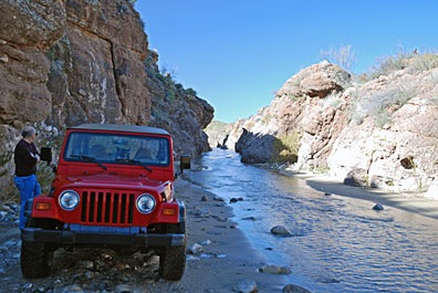 We made a few brief stops. Box Canyon was one of them. But there were motorcycles there with loud engines and we didn’t stay long. Instead, we continued upstream, into the narrow slot canyon. The water flowed from wall to wall within the canyon and I had the windshield wipers going as I slipped around in the soft sand. We stopped for a moment to take a photo of the way we’d come.
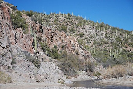
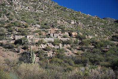 We continued on. The river was flowing through a canyon, but the way was still passable. We soon saw the remains of a mine site on the right side of the hill. We turned the Jeep into a promising canyon where other vehicles had driven but soon reached a dead end where rocks blocked our way. We parked, got out, and hiked up the hill.
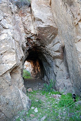 Following a narrow path for a better view down into the river, I came across a tunnel carved into the solid granite at the side of the hill. We passed through and continued onto the other side.
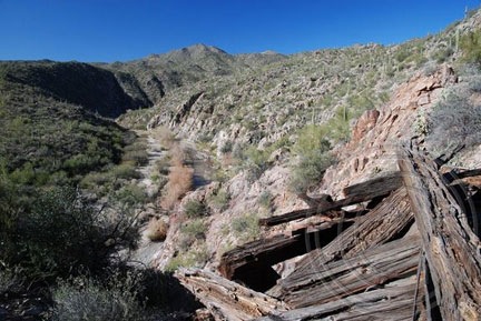
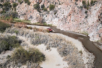 As we admired the view, we heard the sound of a vehicle. Down in the riverbed, a truck was driving downstream. It stopped only long enough for the driver to point out a mine shaft to his passenger, then continued on down the river. I don’t think they saw us or our Jeep.