“I Want to Fly”

E-mail from a reader.

I get the occasional e-mail from readers who evidently think I can perform miracles for them — or perhaps take them by the hand and lead them to the life they dream about. Like this one, which I got today:

I’m 35 no wife or kids and no ties to anything or anyone and want to learn top fly I can get the money to go to a school I just want to change careers and I have learned to live on 35k a year no matter how much income I dont mind being away from home for 14-28 days as long as there is hot showers and the internet please get back to me as I would like to find out more directly from you as to what I should be doing I have looked around for schools and filled out my FAFSA for aid

To the person who wrote this — who I won’t embarrass by mentioning any names — what the hell do you expect me to do for you?

If you’re incapable of doing your own research to find a flight school in your area, you’re likely incapable of learning to fly or getting a job as a pilot, too. Stop whining and begging for help from strangers. You’re 35 years old! Get your fucking act together and make your future happen.

And for chrissake, if you’re going to contact people by e-mail, learn how to punctuate!

Sorry, folks, but this is the end of a long week for me, I have a splitting headache, and I’m spending the night at a Super 8 Motel inhabited by loud drug addicts. Whatever patience I usually have for e-mail crap like what’s quoted above is long gone.

Animals from the Air

Wild horses, antelope, and sheep — oh, my!

I flew from Grand Canyon Airport to Page Municipal Airport (at Lake Powell) again yesterday.

FlightPath.jpgEach time I make this trip, I follow pretty much the same route, hugging the southeast corner of the Grand Canyon Special Flight Rules Area (SFRA) until I get to the Little Colorado River Gorge and then heading pretty much due north. I wind up just outside the SFRA near Marble Canyon so I can show off Navajo Bridge and Lees Ferry before a quick flight past Horseshoe Bend, the Glen Canyon Dam, and Wahweap Marina. If the wind is in my favor, I can touch down at Page within an hour of departure from Grand Canyon. The same distance by car would take about 2-1/2 to 3 hours.

The terrain for most of this flight — from the Little Colorado River Gorge north, in fact — is high desert — technically the famous “Painted Desert” — and relatively barren. There are, however, some interesting features if you look hard for them. Since I’m always trying to point out interesting things for my passengers to see, I look very hard.

Ruins are relatively common. Round rock foundations are the remains of ancient hogans. (This area is on the Navajo reservation.) There are also the remains of animal enclosures, usually build with the same rock. There are complete hogans, some of which may still be occupied for at least part of the year, and ranches with hogans, sheds, outhouses, animal enclosures, and other buildings. All of these things are scattered across an immense landscape that takes more than 30 minutes to cross at 120 miles per hour.

There are also animals.

One of the questions I’m asked quite often by passengers is whether I see wildlife from the helicopter. I do, but not so often as to make it a common occurrence. It depends on where I’m flying, what time of day it is, and how hard I’m looking for wildlife.

Take antelope, for example. There are a few “prairies” north of I-40 and west of Mt. Kendricks in northern Arizona where, if I look hard enough, I can usually spot a herd of antelope. I know where to look and I remember to look. They’re hard to spot because their color matches the terrain so well. It usually takes movement to spot them. When I see them and point them out, my passengers never see them at first. I have to slow down, turn around, and drop a few hundred feet as we approach the herd. That gets them running a bit so my passengers can see them. As soon as they’re spotted — and photographed, if the passengers remember to whip out a camera — I move away. It’s not my goal to terrify the antelope population of northern arizona by buzzing them with a helicopter.

(When I flew at the Grand Canyon, I always saw at least one elk a day in the forest on one of my first or last flights for the day. My passengers never saw them and, since swooping around to show them wasn’t possible, I simply stopped pointing them out. It would be my own private treat.)

There are wild horses in numerous places throughout Arizona. I wrote a bit about them here. They’re also on the route I take from the Grand Canyon to Page. Today, my passengers and I spotted at least four herds of them — the most ever. They’re a lot easier to spot than antelope because of their size and color. But they’re also a lot easier to confuse with cattle. I look for long legs and long, thick tails.

There are domesticated sheep in various places throughout northern Arizona. We flew over a good-sized herd tended by four dogs today. They were a lot farther south than I expected — I usually see them farther north. This could be a different herd, of course. There were about 50 animals in that herd and the dogs did a pretty good job of keeping them together, even when my helicopter spooked them. (Yes, I had to do a circle for my passengers to see them; they were pretty small.)

In the past, I’ve also seen javelinas (pronounced have-a-leenas) from the air. They’re usually in herds of a dozen or more animals and I’ve only spotted them when I was alone, flying a lot lower than I do with passengers on board.

Of course, I don’t have photos of any of this. I’m flying and my hands are usually busy. My passengers never seem to remember to send me their shots. But one of these days, I’ll have some photos to share.

At the Right Place at the Right Time

I tag along on a mystery tour — of the Kolb Studio living quarters.

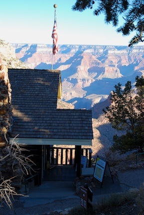
Outside Kolb Studio

The public entrance to Kolb Studio, which clings to the rim of the Grand Canyon.

If there’s any such thing as “luck” I think it has to do with being at the right place at the right time. People who are truly lucky can recognize such an alignment and take advantage of it.

Like I did yesterday.

I was in the Kolb Studio at Grand Canyon Village. The Kolb Brothers were the original photographers of the Grand Canyon. They shot more images of tourism at the South Rim — there are 60,000 negatives in the archives — than anyone else. They also made a movie of their boat trip down the Colorado River through the Canyon and it played daily at their studio for over 45 years, making it the longest running movie in the world. That’s what the Ranger told us, anyway.

Today, the Kolb Studio is known primarily as a bookstore and art gallery. The old movie screening room which is on the second level down, has been converted into a gallery. Last time I was at the Canyon, the gallery was closed for some reason. This time, when I stood at the top of the steps to look down into it, I saw that they were packing up artwork to ship it back to the artists.

But as I stood on that upper landing, a young, thin, female ranger walked by, followed, like a mother duck, by a long string of tourists. There must have been about 15 of them. They were walking purposely down the stairs, past the barrier that had been erected to keep people out. I asked one of the last people, “Is this a tour?”

“Yes. Go to the desk to see if you can join us.”

I knew that if I went to the desk, even if they said yes, I’d be too late. So I just followed them.

Mind you, I had no idea what the tour was about. I had time to kill and it was clear that these people were going someplace I’d never been before. I wanted to go with them.

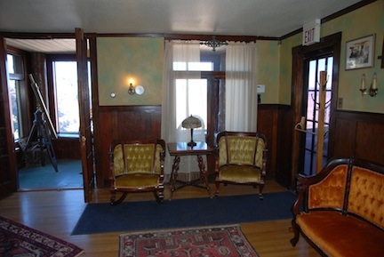
Kolb Sitting Room

The sitting room in the living quarters at Kolb Studio. Beyond this is a “sunroom” with windows looking over the canyon.

I’d hit the jackpot. It turned out to be a tour of the Kolb Studios living quarters — the home of the Kolb Brothers.

Emory and Elsworth Kolb were given a piece of land at the edge of the canyon by Ralph Cameron who owned Bright Angel Trail and a bunch of other land on the rim. This was back in the early 1900s and Bright Angel Trail was a toll road. The Kolbs were given the land with the stipulation that they were to collect the tolls when Cameron wasn’t around. The Kolb brothers built their studio — first a tent, then a wooden frame building — on the edge of the cliff. A window on the building looked out over the start of the trail. The Kolbs would snap photos of the groups of mule riders going down. Then one of them would run all the way down to Indian Gardens, which is 4-1/2 trail miles and 3,000 feet down, where there was water. He’d develop the glass plates, make prints, and run all the way back up to the studio. When the riders returned, the photos were ready for purchase.

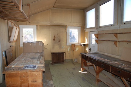
Inside Kolb Studio

Inside the actual photo studio. The window on right right is the one they took photos of mule riders through.

There’s a lot more history to the Kolb brothers, but I’m not about to retell it here. Check out the PBS documentary about them or look them up in Wikipedia to learn more.

The more interesting thing is the house. It was built with its top floor level with the canyon rim. Subsequent floors were added below that. So the house literally clings to the side of the cliff. And it looks as if it were built over time by people who cared more about functionality than architecture.

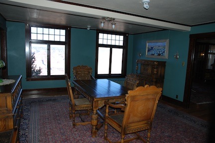
Kolb Dining Room

The dining room at the Kolb Studio living quarters. Those windows look right out over the Grand Canyon.

But inside — wow. A perfect example of early 1900 homebuilding. The house I grew up in was built in 1901, so I know the style. Plaster walls, wood floors, molding. And all the windows looked right into the Grand Canyon.

The ranger led us though about a dozen rooms, including the sun porch, sitting room, kitchen, bedrooms, dining room, and, of course, studio and darkroom. (The darkroom was added after water became available at the Rim.) We were invited to take photos — even through the window the Kolb Brothers had used all those years ago. It was fascinating and a real treat for me.

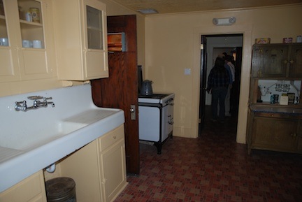
Kitchen at Kolb Studio

The kitchen at Kolb Studio.

Let’s face it: I come to the Grand Canyon at least two dozen times a year. I’ve seen all the usual things. I’ve taken photos from the rim trail and every single rest stop or parking area on the rim. I’ve visited all the shops and eaten in all the restaurants and stayed in all of the hotels. I’m at the point where I’m almost bored when I come here. Almost.

When I finished the tour, the first thing I did was call Mike to tell him. I think he was jealous. Heck, I’d be if he’d gone without me!

Shots from the Edge

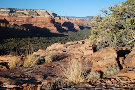
Two photos from yesterday’s hike.

Yesterday afternoon, I hiked up Doe Mountain, a mesa west of Sedona, AZ. The mesa has sheer rock walls on all sides except the northwest — that’s where you’ll find a 8/10 mile trail that climbs nearly 400 feet to the mesa top. The top is almost completely flat with stubby trees, bushes, yucca, and various types of cactus and desert grasses. It’s an amazing place at any time of day; simply walk to the side of the mesa with the view you want, sit down on a rock, and suck it all in.

I went up there around 3:30 PM; sunset was around 5:30 PM. It took nearly an hour for me to do the hike. I can hike on flat terrain or downhill all day long, but make me climb and you’ll be waiting for me. I was by myself, so I didn’t hold anyone back. When I got to the top, I was hot and thirsty.

I wandered around as the light continued to soften and redden. I found an excellent spot for photos on the north side of the mesa and shot the two you see here. These are unedited.

From Doe MountainI’ve been experimenting quite a bit with foreground/background combinations. This shot of grasses, rocks, and trees with the red rocks in the distance behind them really called out to me. The foreground elements are on the mesa top. About 10 feet beyond them is a sheer cliff with a drop of 300-400 feet. The green trees you see beyond that are full-sized pinon and juniper pines. The red rock cliffs are several miles away. This one’s a “keeper” that I’ll likely put in my Photo Gallery. (That’s also why it’s so small here; I don’t share larger images unless they’re watermarked.) The only reason it’s not there now is that I haven’t had time to examine it closely and remove any optical imperfections due to dirt on the sensors. (It’s a never-ending battle against dust here in Arizona.)
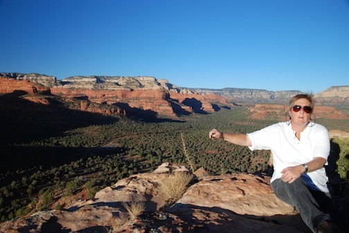
Maria in SedonaThis second shot is a self-portrait. I broke my third wired shutter release and there’s no way I could have used the self-time for this. So I used the camera remote. Of course, the sensor for the remote is on the camera’s right side (when looking at the front) and I was sitting at the left. Hence the stretched out arm and rather cranky look on my face. It’s a dopey picture and I look like an idiot. I guess that’s why I like it.

Oh, and I was about 5 feet from the edge of the cliff in this shot.

More from this trip in future posts. I’ll have better WiFi in Page.

Smooth Day for Flying

Let’s hope I get six like this in a row.

I start my final Southwest Circle Helicopter Adventure 6-day helicopter excursion for 2009 today. And after a week of extremely blustery weather — by Arizona’s standards, anyway — it looks like we have a week with calm wind conditions.

I can’t express how happy I am about that. While I’m not afraid to fly when the wind is howling — even up to 20 or 30 knots — it’s so much more pleasant to fly without all that wind. You can really feel the joy of flying when there isn’t some natural force (other than gravity) messing with your flight path.

Wind makes for mountain turbulence, which is caused by the flow of air over uneven terrain. Think of a stream with rocks in it. How does the water move over and around those rocks? Now imagine the water being air and the rocks being hills and mountains. Helicopters are flying only 500 to 1000 feet off the surface, so we’re in all that bumpy air. The more wind and hills and mountains, the more bumps. It’s usually not bad enough to be unflyable, but it’s certainly a lot more pleasant to fly when you’re not being bumped around all the time.

When I flew at the Grand Canyon, it was windy every day from April into June. Oddly, the bumpiest air usually occurred during flight segments over the National Forest. We were 300 feet over the ground, not far from the ponderosa pine treetops. The ground was gently rolling plateau that ended abruptly at the edge of the Canyon. It was the rolling hills that set up the bumpiest air. Over the canyon, with several thousand feet of open air below you, the wind wasn’t nearly as bumpy — despite all those buttes and “temples.”

Anyway, I’m looking forward to a smooth flight, where each moment in the air feels like gliding through space. Let’s hope it holds out for the whole week.