
Notes from halfway down the long drive from Wickenburg to Seattle.
I’m writing this from a Walmart parking lot. I’m propped up in a queen sized bed with three pillows behind my back and my laptop on my lap. It’s 3:30 in the morning and I’m pretty much wide awake after just over five hours of sleep. It isn’t noise that woke me — this Susanville, CA parking lot is remarkably quiet. I guess I’m just done sleeping for the night. But it’s too early to continue my travels along winding mountain roads, so I figured I’d share an update on my blog.
This isn’t a pleasure trip — although parts of it have been very pleasant. It’s for work; I’m repositioning a truck and my new RV from Arizona to Washington State for the summer. The RV will be my home away from home as I work on cherry drying contracts for central Washington growers. The truck is needed not only to pull this massive fifth wheel trailer but to carry the refueling system I need to meet my contractual obligations.
The Truck
I’ve written about my new RV elsewhere in this blog, so I won’t repeat that here. But I’ve probably neglected the truck. It’s my husband’s truck: a 2001 Chevy Silverado 3/4 ton pickup. It has a Duramax Diesel engine with towing package and an Allison transmission. A “man’s” truck, capable of towing more than 15,000 pounds. (We bought it new in 2001 to tow a horse trailer with living quarters that I’ve since sold.) Inside, it has many creature comforts, including heated leather seats, power windows, and stereo system with iPod connection. The truck runs well and is up to the task of towing my home away from home over 1,000 miles.
I’ve mounted my old Garmin 60c GPS over the dash and have it wired into one of the DC power outlets. I’d loaded in topo maps (my preferred map type) for my entire route and then some. I’m using it mostly as a trip computer, to calculate distance driven, average speed, etc. I’m keeping close track of fuel consumption so I can calculate burn rates.
I’ve also clipped my cell phone case to the visor and connected it to another DC outlet. I’m wearing my Bluetooth earpiece for most of the trip for safer hands-free communication — when I can get a signal. Verizon has the best network — which is why I use it — but even Verizon doesn’t cover some of the places I’ve driven through on this trip. I can hear the signal fade in and out with beeps in my right ear as I drive.
The Route and Stops
If I’m traveling — whether by helicopter or on a long drive — you can usually follow my SPOT Messenger track online at tinyurl.com/FindMaria
Every year I choose a different route for this drive, shunning freeways as much as possible. This year, the route included stops to visit with friends in Las Vegas and Reno, NV, and Ashland, OR. The route began in Wickenburg, AZ and headed west on route 60. What followed was a numeric alphabet soup of route numbers: 72 and 95 to Parker, 62 and 95 to Needles, 40 and 95 to Boulder City, 95 and 215 to Las Vegas, etc. You get the idea.
In Vegas, I visited with my friends Jim and Judith. Jim is a helicopter pilot who flies a Hughes 500c. He and his wife, Judith, lived in Wickenburg for quite a while but, like most of our other friends, bailed out when the saw the reality of the situation there. They moved to the San Diego area for a while, then various places in California, and finally in Las Vegas.
Jim, an airline pilot who took early retirement years ago — luckily, before the airline went belly up — is an inventor. He designs, manufactures, and sells power external aircraft power units called StartPacs. They’re used primarily for starting turbine engines, although he has a whole range of power products now, from power sources a pilot can use while fiddling with his avionics on the ground to big, self-propelled APUs for bizjets. When they left Wickenburg, they took their business with them. They now employ a handful of people in their Las Vegas office and manufacturing facility. Jim gave me a tour after lunch on Monday and showed me some of the new designs he’s gotten patents for.
I left Vegas and headed west and then north through Pahrump. Another road took me west again. By 4 PM, I was in Death Valley. Although the temperatures should have been topping 100°F there this time of year, it was unseasonably cool, in the high 80s, with plenty of cloud cover. There were also signs of rain coming from the clouds, but the ranger at the Visitor Center assured me that it was unlikely for any drops to reach the ground.
On one ranger’s suggestion, I made my way to Panamint Springs. After a long, slow climb up over the mountains, I experienced a harrowing descent down a 9% grade. The truck’s tow package really helped out, downshifting to 2nd gear automatically to reduce my need to ride the brakes. Note to self: avoid Route 190 between Stovepipe Wells and Panamint Springs when towing a 36-foot RV.
Panamint Springs is still inside Death Valley National Park, but it overlooks the Panamint Valley, which is one valley west. It consists of a motel-like lodge, restaurant, and dirt lot dressed up as a campground. I paid $15 for a water-only hookup for my RV for the night. (I didn’t bother hooking up; I didn’t need water.) I had a heck of a time getting the RV into its pull-through spot. Although it was plenty long enough, the campground designers had placed large boulders at either side of the driveway. Making the turn without damaging the RV’s underside was tough. But I eventually managed and Alex the Bird and I settled in for the evening. I watched the changing light on the mountainsides from a patio table at the restaurant. At night, it was dead quiet and very dark. I stepped outside to admire a sky full of stars with a crescent moon before turning in for the night.
The next morning, I was on the road at 7 AM, continuing west on Route 190. After fueling up just outside of Lone Pine, I continued north on Route 395. I didn’t realize that route was so mountainous. After leaving Bishop, the truck did a lot of climbing, eventually reaching over 8,000 feet elevation. (This was the day after descending to -230 feet in Death Valley.)
On the urging of my friend, Rod, I detoured to the Ghost Town of Bodie. That required me to negotiate 14 miles of narrow, windy road, the last three of which were unpaved. I was extremely pleased to see that the parking area was large enough to make a U-turn in without having to back up. I put Alex in the camper while I went to explore the townsite on foot with my camera. I’ll likely write about that in another blog post, when I get the photos off my camera.
I met Rod for lunch in the Reno area, not far from where route 395 intersects with I-80. Rod lives in Georgetown, CA; I’d visited him and his wife, Liz, there by helicopter several times in the past. This time, I was on the other side of the Sierra Nevada mountains and wasn’t planning on crossing. But Rod made the 2+ hour drive from Georgetown to Reno to meet with me. Rod’s also a helicopter pilot — he flies fires in twin-engine helicopters like Hueys — in the summer. The rest of the year, he does odd jobs around home. We had a very late lunch in a Chinese restaurant in Sparks, NV.
Then I continued my drive north on route 395, ending up here in Susanville.
Highlights of the Trip
I’ve driven through some beautiful scenery over the past two days. Snow-capped mountains, sheer granite cliffs, dry lake beds, sand dunes, layered rock thrust up on an angle and eroded to expose lines of color. Blue lakes, rushing rivers, puffy white clouds in otherwise clear blue skies. Herds of wild burros, pastures full of horses and cattle, deer. The ruins of a town in the middle of nowhere that once was home to over 10,000 people.
It’s all a blur. A trip like this on a route like this shouldn’t be crammed into a few days. It should be slowed down and savored, with stops here and there to take in the sights and sounds and smells. This isn’t quality sightseeing — it’s motoring. I may as well be on a freeway.
Later today, I’ll drop down from the mountains to I-5 near the Oregon border. From there, I’ll follow the Interstate north into Oregon. After another lunch with another helicopter pilot friend, I’ll make my way north to the Seattle area. I’ll camp out in yet another helicopter pilot friend’s yard. Whether I can get there today depends on how twisty and mountainous the roads between Susanville and I-5 are; I’ll know by lunchtime.
 The image shown here shows the four days of my flight. Day 1 was
  I was airborne by 10 AM.
 I was now squarely in the middle of my middle-of-nowhere route from Page to Bryce Canyon. There were absolutely no signs of civilization below me or anywhere within sight. Instead, an ever-changing terrain revealed itself below me. Hills and mesas were cut deeply by canyons of exposed red rock. Sedimentary rock thrust up from the ground at odd angles, forming layered ridge lines that stretched for miles. Ancient sand dunes turned to rock stood revealed by the erosive forces of wind and rain over millions of years.
  The view seemed to change every five minutes, revealing wonder after wonder. I wanted to detour and explore. I wished more than ever that I’d installed my helicopter’s nose camera before departing Wickenburg the day before.
 I finally began seeing signs of civilization: paved roads, ranches, towns. There were plenty of red rock cliffs and hoodoos with roads — paved and unpaved — winding around them. Funny how people go to National Parks to see the sights when the same sights — or better ones — can be found right down the road.
 So we did a quick circuit around Gunsite Butte and Alstrom Point, then hustled up the lake toward Rainbow Bridge. Although the forecast had called for 50% overcast and morning winds up to 10 MPH, the sun was bright but filtered and the wind was not an issue at all. Flying toward the sun, the views weren’t very good, but glances to the left or right as I turned showed stunning morning views of the lake and red rock cliffs. My client didn’t provide much instruction, so I didn’t waste his time by being a tour guide. (Note that this photo and all the others that appear in this post were taken at other times; I can’t take pictures while I’m flying with clients aboard.)
 We had a bit of a tense time when my client asked me to fly lower near Rainbow Bridge. The problem is, Rainbow Bridge is at the bottom of a narrow canyon. I know that I can get down to 5,000 feet MSL safely, so that’s what I always shoot for. He wanted me lower. That would bring me very close to a canyon wall. When I pointed that out, he backed down. I think he may have been spooked. But I gave him a good look at the bridge and was satisfied to hear his camera clicking right through his microphone.
 He asked me to take him to Horseshoe Bend and I headed out that way. I purposely swung past the Glen Canyon Dam, putting it on his side of the aircraft so he could take photos. I heard his camera snap. Then I climbed — Horseshoe Bend is best seen from at least 6,000 feet — and headed downriver. A few minutes later, I pointed out Horseshoe Bend and began making a climbing circle to the left around it. I was about 270° into it when he told me we were done.
 I climbed steadily at about 200-300 feet per minute, gaining altitude slowly to clear the 5,000 foot Weaver Mountains ahead of me. Below me, I could see the scars the near-bankrupt developers had left on the desert where Routes 93 and 89 split off. Greed had scraped the desert clean, built a golf course, and then let the grass wither and die. Where there was once pristine rolling hills studded with cacti and small desert trees, there was now flattened dirt, void of vegetation, shaped by bulldozers and men. A dust bowl on windy days covering hundreds of acres of Sonoran desert.
 The weather up ahead gave me a good idea of what I’d be facing for much of the trip: a never-ending series of isolated rain and snow showers. They appeared as low clouds with hanging tendrils of wispy precipitation. But unlike the gray rains hanging below summer rainclouds, these were white, making me wonder whether I was looking at rain or snow. With outside air temperature around 4°C (40°F), it could have been either. Or something worse; damaging hail or icy sleet.
 Near the Drake VOR, I detoured more to the east to avoid a rapidly approaching shower. Raindrops fell on my cockpit bubble and the 110 wind of my airspeed whisked them away. The sky was clearer ahead of me, although the tops of Bill Williams Mountain was still shrouded in clouds. The Prescott (KPRC) ATIS reported mountain obscuration and snow showers to the north, east, and west. I couldn’t see the San Francisco Peaks, which were likely getting more snow to extend the skiing season at the Snow Bowl.
 Then I was back out in the sun — a good thing, since the outside temperature had dropped to just over freezing and my cabin heat wasn’t able to keep up with the cold. I climbed up the Mongollon Rim just west of Bill Williams Mountain, trading high desert scrub for ponderosa pines. The mountain had recently been dusted with fresh snow. That didn’t surprise me; only three hours before, the airport at Williams (KCMR) had been reporting 1/4 mile visibility.
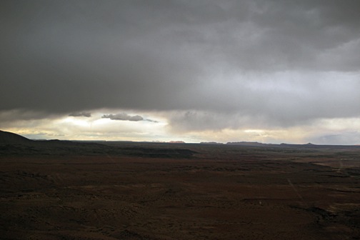 I passed through the rain and emerged on the other side with a clean cockpit bubble and likely very clean rotor blades. Ahead of me, now due north again, the sky was brighter and I could clearly see the Echo Cliffs. Before entering the storm, I’d punched Tuba City (T03) into my GPS to keep my bearings; now I punched in Page (KPGA) and was pleased to see that I was already right on course. I aimed for The Gap, a small town at the gap in the cliffs, right on Route 89, adjusted power to maximize speed, and sped forward, 500 feet off the high desert floor.
 I crossed Highway 89 at The Gap and flew through the gap in the Echo Cliffs. I was now about 45 miles from Page, flying among three sets of high tension power lines that stretched from the Navajo Generating Station on Lake Powell to points south. There was a dirt road here that made a short cut to page — if you didn’t mind driving more than 40 miles on a dirt road. Navajo homesteads were scattered about. The sky was a mixture of clouds and patches of deep blue. I warmed in the sunny spots and cooled in the shadows.