We spend some time along the retreat route.
Fort Lee, NJ is a town on the Palisades of the Hudson River. It’s known primarily for two things: the George Washington Bridge crosses the river at Fort Lee to the upper end of Manhattan island and George Washington’s retreat route runs right through it.
Of course, there was a fort. It sits high on the Palisades, just south of the bridge. There isn’t much left of it, but there is a nice park with paved paths and lookout points with benches. The Americans used the fort to lob mortars onto British ships sailing up and down the river.
Until the Americans ran away.
I’m making fun, of course. Back in those days of the Revolution, the American army did a lot of retreating. What’s weird is that there are signs along the retreat route proudly proclaiming that they ran away right past where the sign now stands. But we did win.
We had some time to kill before meeting my sister and brother and some others for dim sum, so we went for a walk in the park. And we got a few treats.
 The first treat was the re-enactment stuff going on. I don’t know if they do this every Sunday or if we just happened to stop by on the right day, but there were men in revolutionary war uniforms doing the kinds of things the soldiers did back then. Like marching around with a drum and fife. Or with guns. Or setting up a camp near the mortar lobbing area. Or building a shelter without any modern tools.
 I don’t know why these guys were there, but they were definitely into it. Their outfits looked great — but a lot cleaner than they would have been 230 years ago. Sadly, there weren’t many spectators. The park was pretty empty. It was as if they were performing for themselves. Maybe something was going to start later on. We didn’t hang around. We had dim sum to eat.
 We also spent some time at one of the lookouts, watching the bridge and the river flowing beneath it. I took some pictures (of course). And I can recall some of the facts that I’d read about the bridge while in my hotel room.
The George Washington Bridge — or GWB, to the locals — was once the longest single span suspension bridge in the world. It’s still one of the 15 longest. (It’s about 2 miles across the river.) It was built in the 1930s and was originally designed with two levels of roadway, but budget cuts kept the bridge to just the upper level until the early 1960s when the lower level was added. It’s the primary crossing from New Jersey to New York — I can’t remember how many millions of vehicles cross each day. The bridge’s original design called for the towers to be faced with local stone so it matched the Palisades on the New Jersey side. That plan was nixed along the way and the bridge is painted regularly. They just finished doing some rennovation on the towers — you can still see some of the scaffolding on the New York side in this photo.
When I was a kid, my family had a small motor boat. We kept it at home, on a trailer. We’d go boating in the Hudson River. The boat ramp we used is just south of the tower on the New Jersey side. We’d go on day trips around Manhattan island or past Ellis Island (before they fixed it up) and the Statue of Liberty. The water in New York Harbor was always rough; the water in the Harlem River was always smooth. Hells Gate, where the rivers came together with the Long Island Sound, was a crapshoot.
 Anyway, I also took some time to lay back on the bench and look up at the sky through the leaves of an oak tree. It was nice to be among trees that were a good deal taller than I am. The area is lush with vegetation, like a jungle waiting to reclaim the land.
And just beyond it is I-95 with traffic and exhaust and the sound of cars and trucks.
We left the park right around noon and headed into town. Fort Lee (or Fort Ree, as we sometimes call it) is known for another thing: good Asian food. With a huge Chinese, Japanese, and mostly Korean population, it shouldn’t be a surprise.
Want some of the best dim sum in the New York metro area? Go to Silver Pond on Main Street in Fort Lee. You won’t be disappointed.
And if you have time, check out the Fort Lee Historic Park. Maybe those guys will be camped out again.
 Lynn got me settled in and we had some wine by one of the two creeks that flowed past her house. Then we went for a walk in her alfalfa field. This is the view from the end of the field, looking back toward her house.
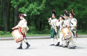 The first treat was the re-enactment stuff going on. I don’t know if they do this every Sunday or if we just happened to stop by on the right day, but there were men in revolutionary war uniforms doing the kinds of things the soldiers did back then. Like marching around with a drum and fife. Or with guns. Or setting up a camp near the mortar lobbing area. Or building a shelter without any modern tools.
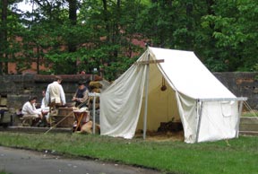 I don’t know why these guys were there, but they were definitely into it. Their outfits looked great — but a lot cleaner than they would have been 230 years ago. Sadly, there weren’t many spectators. The park was pretty empty. It was as if they were performing for themselves. Maybe something was going to start later on. We didn’t hang around. We had dim sum to eat.
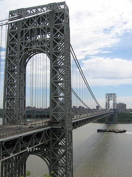 We also spent some time at one of the lookouts, watching the bridge and the river flowing beneath it. I took some pictures (of course). And I can recall some of the facts that I’d read about the bridge while in my hotel room.
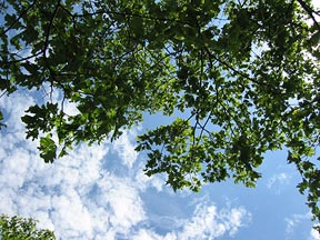 Anyway, I also took some time to lay back on the bench and look up at the sky through the leaves of an oak tree. It was nice to be among trees that were a good deal taller than I am. The area is lush with vegetation, like a jungle waiting to reclaim the land.
 But Sunday I was there.
 I’d woken that morning in Montana, at a friend’s house, and had taken the scenic route south, through Yellowstone National Park. South of that park, I reached Jackson Lake with this late afternoon view of the Grand Tetons.
 I couldn’t remember where this photo was taken, either. I knew it was in Maine and I knew I’d taken it on one of our outings with John and Lorna. So I e-mailed Lorna a copy of the image and asked her. The response came back almost immediately: Samoset Resort in Rockland, ME.
 You also can’t see the building at the end of breakwater about a mile from where this photo was taken. Here it is. It was a lighthouse and apparently still functions as one. But it’s closed to the public, so you can just walk around it or onto its stone steps. We spent some time sitting out in the sun, watching the boats go by. It was a peaceful, relaxing place. There was some fog in the trees on the other side of the channel — the same fog we’d walked through earlier in the day when visiting the Owl’s Head Lighthouse. (Did I get that one right, Lorna?)
 I took this photo of John and Lorna on the way back to the car. John’s not an easy guy to get a picture of. It seem like every time you tell him to stand still and pose for a picture, he acts like he doesn’t believe someone’s really going to take his picture. So you have to take a few of them in a row for one of them to come out natural enough to use. This one gets them both.