Cross-Country by Helicopter: E25 to BFI

14.4 Hours over four states.

Cross-Country, Defined
For those of you who are not pilots, allow me to explain the term cross-country as used by a pilot. A cross-country flight is basically any long flight with a landing a certain minimum distance from your starting point. For airplane pilots, it’s at least 50 miles. For helicopter pilots, it’s at least 25 miles. So while this blog entry discusses a very long cross-country flight, we did not fly all the way across the country.

This past Thursday and Friday, I flew by helicopter with two other helicopter pilots, Ryan and Bryan, from Wickenburg, AZ to Boeing Field in Seattle. Bryan and Ryan did just about all of the flying. I sat up front being a nervous passenger when we were near the ground and playing with the radio and GPS. Brian let me make most of his radio calls on the first day, but I didn’t get to do much of that the second day.

It was a mutually beneficial journey. I needed to get the helicopter from Arizona to Washington State. Ryan and Bryan were both CFIs who wanted to build time in an R44 helicopter. It was way cheaper for them to fly with me on this trip than to rent an R44 from a flight school. There was also the added experience of planning and executing a flight through unknown terrain, with fuel stops and an overnight stop along the way. And the money they paid to fly my aircraft helped me cover the cost of this very long and very expensive helicopter flight. Win-win.

Corona Fuel

A very cool but very helicopter-unfriendly fuel island at Corona Airport in California.

Our flight path took us west, with Bryan at the controls, along state route 60 to I-10, across the Colorado River, and then along I-10 through Bythe, Chiriaco Summit, Palm Springs, and Banning; then back on 60 past March to Riverside on the 91. We stopped at Corona for fuel at what’s likely the coolest but most helicopter-unfriendly fuel island in the world. (We didn’t notice the separate fuel island more suitable for helicopters until we’d stopped and shut down.)

Here’s a video of our transition along the California coast through the LAX airspace on the Shoreline transition route. You might want to turn down the sound while playing it; lots of helicopter noise.

Then Ryan took us west on 91 through the airspace for Fullerton and Long Beach, with a Torrance low pass. (Robinson has entirely too many helicopters waiting for owners on its ramp and in its delivery room.) He then got clearance for the Shoreline helicopter transition of LAX space, which requires the pilot to drop to 150 feet 1/4 mile offshore to pass under LAX departing traffic. We continued following the coast up past Santa Monica, Pacific Palisades, Malibu, Oxnard, Ventura, and Santa Barbara. By then, the marine layer was moving in, so we went inland for a bit. Eventually, we reached San Luis Obispo (and the chatty controller) and stopped for fuel and lunch.
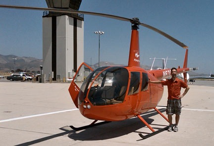
Ryan at San Luis Obispo

Here’s Ryan on the ramp at San Luis Obispo before departure northbound. I shot this one with my Blackberry’s camera, so pardon the quality.

Bryan was back at the controls for our departure northbound. After a very close call with a large bird, we followed the path of Route 101 northbound. Most of the route was up a riverbed in a very pleasant valley. We got to Salinas and realized that any coastal route would be out of the question — the marine layer was creeping in even there. So we headed over the mountains, eventually ending up in the western part of California’s Central Valley. We stopped for fuel at Byron.

Ryan took over and we continued north over Rio Vista and Yolo, finally hooking up with I-5. We followed that through endless farmland — much of it flooded for a crop that apparently needs lots of water — over Willows Glen and Red Bluff, with more than a few crop-dusters flying nearby at altitudes far below ours. We stopped for the night at Redding, tied down the helicopter, and got a hotel shuttle into town.

We’d flown 8.8 hours.
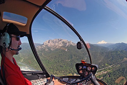
Ryan Flying Near Mt. Shasta

Ryan at the controls as we near Mt. Shasta in northern California.

The next morning, we were back at the airport at 9 AM, preflighting and getting ready to go. Ryan would start the flight. We headed north along I-5, over Lake Shasta and past Mount Shasta, which was snow-covered and beautiful. We were now past Central Valley’s vast farmland and up in the mountains. We flew past Weed, Siskiyou Co., Rogue Valley/Medford, and Grant’s Pass. Much of this flying was in canyons, along the same route as I-5 and a train line.

Things turned a bit iffy as I-5 swung to the east. We were hoping to go north and catch it on the other side of some mountains, shortening our route a bit, but clouds sitting on the tops of those mountains made that a bit uncertain. So we dropped altitude, slowed down, and followed I-5. Ryan flew while Bryan and I kept a sharp lookout for the power lines we knew — from both chart and GPS — were ahead. We weren’t that low and there wasn’t any real danger, but we were certainly not coming out of that canyon anywhere except the I-5 corridor. We passed the powerlines with plenty of room. The road descended into a valley and we stayed up beneath the cloud bottoms. Eventually, the sky cleared. We continued along I-5 past Myrtle Creek and Roseburg and stopped at Cottage Grove State for fuel and lunch.

Then it was Bryan’s turn again. We continued up I-5 past Hobby, Albany Municipal, and McNary. Then we headed northwest over Sportsman’s, Hillsboro, and Scappoose. We crossed the Columbia River and headed north on I-5 again over Kelso Longview and Olympia, with nice views of Mount St. Helens and Mount Rainier in the distance. Then on to Bremmerton, where we stopped for fuel. We probably had enough to make the last 20 minutes, but why take chances?

At BFI

Zero-Mike-Lima on the ramp at BFI. Another Blackberry photo. And yes, that’s Mt. Rainier in the background.

I flew the last leg with Bryan up front to handle the radio and give me directions. It was only a 15-minute flight, but the airspace was complicated, so I was grateful for the help. I set the helicopter down sloppily in the parking area. We’d flown a total of 14.4 hours.

It was a great flight. We saw so much that most of it is just a blur in my mind. With luck, these photos and videos will help me remember the trip for a long time to come.

Many thanks to Ryan and Bryan for accompanying me on this trip. I hope they learned a lot about cross-country flying.

Real Life Helicopters: Wildlife Survey Flight

How I spent yesterday morning.

At 5 AM yesterday morning, I was at Wickenburg Airport (E25), filling two 5.5-gallon plastic fuel cans with 100LL. I had already topped off the helicopter’s tanks and it was sitting on the ramp, waiting for me in the predawn darkness. I was scheduled to do a wildlife survey in northern Arizona at 6:30. I’d have to pick up my passenger at Williams, AZ (KCMR), an hour away by helicopter. There was no fuel at Williams, and the closest fuel stop to Williams and our survey area was 20 NM north at Valle (40G). The FBO didn’t open until 8 AM, so I wouldn’t be able to get fuel before then. The survey area was 40 NM from fuel at Valle. I wanted my client to get as much air time as possible before our first refueling stop, so I figured I’d put the 11 gallons of 100LL that I carried with me into the tanks when I arrived in Williams.

So that explains why I was at the self-serve island, filling two plastic gas cans before dawn.

A while later, I was airborne, heading north to Williams. The two gas cans were strapped into the back passenger seats. They were good cans and wouldn’t leak on my leather seats. On board was an overnight bag, in case the job went two days, a 6-pack cooler full of bottled water, and the usual survival gear. I was listening to Steely Dan on my iPod as the sun rose at my 2 o’clock position. Moments later, I crossed the ridge east of Antelope Peak, clearing it by a mere 100 feet. From there, I sped north at 110 knots airspeed to get to Williams as quickly as possible.

At Williams, AZ

I had a tail wind and the wind was blowing pretty good at Williams. 210 at 9 gusting to 18 is what the AWOS reported. There was no one in the pattern. There never is at Williams. I made all my calls, then came around from the north to land into the wind on the big, empty ramp.

The terminal, which is very nice but completely underutilized, was unlocked. “Out of Service” signs appeared on both restrooms and the water fountain. I peeked into a stall in the Ladies room. There was water in the toilet bowl. That meant it would flush, even if it didn’t refill. I had to go so I took my chances. It worked fine. That made me wonder why the signs were there.

I was topping off the tanks with those two cans of fuel when my passenger arrived. He showed me maps and we made a plan. The main part of the job was to fly down the side of a 1,000-foot cliff face, 50 to 200 feet off the top, depending on where the rock ledges were. The cliff ran north to south. The wind was coming out of the south. Although my client suggested starting from the south, I pointed out that if we started from the north, the cliff face would be on his side of the aircraft and I’d be able to fly into the wind. That would make things easier all around. He agreed.

I added some oil, burning my fingers on the hot dip stick. We climbed in, I started up, and we took off, into the wind. A westerly heading put us on course for the survey area.

It was about a 30-minute flight. We chatted about this and that. My client was a youngish guy — certainly younger than me — and had spent more than 200 hours in airplanes and 20 hours in helicopters doing surveys like the one we were doing. As the morning wore on, he’d share a lot of his knowledge about raptors — specifically red-tailed hawks and golden eagles — with me.

The Survey

Cliffs
Satellite view of the cliff face we flew down.

We reached the survey area and I geared my mind down from 110-knot flight through 60-knots and finally down to about 20-knots. We’d survey the cliff face at this slow speed, about 50 to 100 feet away from the rock wall.

While this sounds very dangerous, it really wasn’t bad at all. Although it had been windy at Williams, it wasn’t very windy along the cliff. That might be because the wind was coming from the southeast and the tilted mesa beyond the cliff was blocking the wind, or, more likely, it simply might not have been as windy this far west. So It wasn’t as if I had to fight the wind. Flying was easy.

There were just two of us on board, so I had plenty of power, even though I was flying at about 7,000 feet MSL. I was even able to bring the helicopter into a rock, solid out-of-ground-effect hover a few times as needed.

Best of all, if I had any kind of problem — loss of tail rotor effectiveness (LTE), settling with power, engine failure — I could easily build speed by pulling away from the cliff face to my right, where a huge, open, flat valley offered unlimited landing zones at least 500 feet below us.

Frankly, I couldn’t have asked for a better setup for this kind of work. It gave me an opportunity to practice simple flying skills — especially OGE hovering and sideways flight — without having to battle the wind or worry about escape routes.

It took at least an hour to travel down the cliff face from north to south. There was a radar dome at the very south end and we could clearly hear it in our headsets, the closer we got to it. By the time we were within 1/4 mile, the sound was very annoying. I dropped beneath it to round the end of the mesa and it silenced. I realized that this was what “below the radar” really meant.

On the other side, we followed the edge of the mesa, which wasn’t nearly as well defined, north. Again, there wasn’t much wind. There also wasn’t much wildlife to survey. We popped over the top of the mesa and began following small canyons on its east side. We were looking for raptor nests. We’d found some on the cliff face, but they could also be in tall trees.

The mesa-top stuff was low-level — probably 50 to 100 feet AGL — at 30 to 60 knots airspeed. This is considerably more dangerous than the cliff face work we did earlier. It would be difficult, if not impossible, to recover from a settling with power or engine failure incident at that low airspeed/altitude combination. One of the reasons I got the job to work for this client is that I was willing to do this kind of flying. The first company they called — a flight school — refused to let its pilots fly like this. I’m willing to take this risk, so their loss is my gain.

At one point, I landed in a wide canyon so I could strip off my outer shirt. It was getting hot in the cockpit, flying so slowly with the sun shining in. We also dipped in the cooler for cold water. I didn’t bother shutting down. It was a 5 minute break and we got right back to business when we were done.

We’d flown for 2 hours from Williams when I decided it was time to go back for fuel. We traced a route northward to the edge of the survey area, then cut east to Valle. I used my GPS to pick the most direct route. There wasn’t much of interest along the way. Northern Arizona has lots of high desert plateau areas that are covered with dried grasses and a sprinkling of trees.

It took about 25 miles to get to Valle. We had a tail wind.

At Valle

Valle Airport is about 25 miles south of the Grand Canyon. I won’t pretend to know its history. I do know, however, that it’s home of the Planes of Fame Museum, which is an excellent little warbird museum. And I know that the lobby of the airport terminal is absolutely crammed with antique cars and trucks in museum quality condition.

And there were no “Out of Service” signs on the rest rooms.

The FBO guy filled the helicopter tanks and the two fuel cans. The idea with the cans was that if I flew too long on the survey and we couldn’t make it all the way back to Valle to get fuel, I could always land out in the desert, shut down, and add the 11 gallons. That would get me another 40 minutes of flight time, which was enough to reach any number of fueling locations.

I paid for the fuel and we went back outside. The FBO guy had managed to drench the fuel cans with fuel, so I had to dry them off and close them tightly before I could load them back in. I put shop towels under them to protect the seats. Still, one of them leaked a tiny bit during the flight that followed — not enough to do any damage, but enough for me to catch the occasional smell of 100LL.

We headed west again. It took nearly 35 minutes to reach the survey area. We had a head wind.

More Survey Stuff and the Flight Home

We spent the next two hours inching our way along the same cliff face. The light was better now and we spotted another nest. We also did another nearby cliff face and spent a bunch of time zigzagging along the mesa top. We found three more nests up there. The wind had also picked up, so the flying was a bit more challenging. But I’ve flown worse.

Then we headed south to check another area. We found an active prairie dog village there.

And then we were done.

I dropped my passenger off without shutting down. It was 85 NM back to Wickenburg from that point and my goal was to get there without having to detour for fuel or stop to tap into that 11 gallons on board. I bee-lined it, cruising at my best range speed of 100 knots.

For a while, as I flew over empty desert, I thought I might not make it. I considered the kind of place I could land and refuel without bothering anyone. There was no airport on or near my flight path. There wasn’t much of anything other than small mountain ranges, canyons, and rocky outcroppings. I passed over only 3 paved roads.

Then I was 15 miles north of Wickenburg, with about 8 gallons of fuel on board. No problem.

I landed and shut down. It was 95°F on the ramp. I put the helicopter away.

I’d flown 6.5 revenue hours and had learned a hell of a lot about birds.

The Challenges of Aerial Photography

It ain’t easy.

A lot of people think that aerial photography is easy. Go up in an aircraft and snap a photo. What can be easier than that?

Truth of the matter is, it’s not as easy at it seems. Mike and I learned this a while back, when we attempted to provide aerial photography services when I owned an R22 helicopter. And as a business person, photographer, and pilot, I have a unique perspective on the topic.

The way I see it, problems fall into three areas.

Client’s ability to accurately communicate what he wants a photo of.

Some clients — those are the folks who want the photos — simply can’t communicate what they want a photograph of. Couple that with their unreasonable expectations of what the photographer can do and the photographer’s failure to communicate his limitations and you’ve got a recipe for disaster.

Take, for example, one of our early photo shoots. A guy owned 10 acres of land southwest of Wickenburg. He hired us to photograph it from the air so he could use the photograph as a selling tool. What he failed to explain is that he expected a straight-down image, almost like a super zoomed in satellite view. The aircraft that take those kinds of photos are airplanes with belly cameras flying at 10,000 feet or higher. We can’t shoot straight down with our setup. The client said he wanted a photo of his land from the air. When we provided a very usable image from 1,500 feet up, slightly to the south, the client was very disappointed.

If you’re reading this as someone who needs aerial photos of a specific place, take the time to talk to the photographer and tell him exactly what you need. Draw pictures if you have to. Make sure he understands and can deliver what you need.

Photographer’s ability to communicate what he wants the pilot to do so he can get the shot.

This is the one that I, as a pilot, run into all the time. This problem appears to break down into three separate causes.

  • The photographer thinks I’m a mind-reader and that I know what he wants to shoot, so he doesn’t provide instructions. When I don’t get the aircraft in the right position, it’s my fault because I couldn’t read his mind.
  • Horseshoe Bend with Plane
    My helicopter was part of the equipment for this shot by Mike Reyfman. We were in an OGE hover 2,000 feet above the canyon when this plane came into view 1,000 feet below us.

    The photographer doesn’t understand exactly what a helicopter can do. Yes, if it isn’t too windy or we’re not too heavy or high, I can hover on point so you can get the shot. Yes, I can make a sharp turn — left or right — around the target. Yes, I can climb almost straight up (or descend almost straight down) to change the angle of the shot. Yes, I can fly sideways, at slow speed, to keep the target in frame. Yes, I can chase the target at almost any altitude or speed needed, keeping the target in front, beside, or behind the aircraft. But if the photographer doesn’t ask for any of these things, I’m not going to volunteer them. After all, I’m just the pilot — not the photographer.

  • The photographer seems almost afraid to ask me to fly the way he needs me to. Maybe he’s flown with other pilots in the past who simply would not perform the maneuvers he needed. (I get a lot of my Phoenix-area photo business because one local helicopter operator refuses to fly below 300 feet or slower than 60 knots — not exactly flexible enough for aerial photography.) Some photographers may believe that all helicopter pilots set arbitrary limitations on how they’ll fly and don’t want to push. I don’t know about you, but if I’m paying a pilot $450/hour to fly me around to get the shots I need, I’m going to ask him to do exactly what I need him to do. If he says no, I won’t push. But if he says no to everything I ask, I’m not likely to call him again.

Pilot’s ability to put the aircraft where it needs to be to get the shot.

Sometimes the pilot just can’t do it. This could be because of lack of skill, lack of aircraft performance capability, or lack of space for maneuvering the aircraft:

  • Wheat Harvest
    My buddy, Jim Van Sky, was flying his helicopter in central Washington state last summer when he put me in position to get this shot. Jim is a highly skilled pilot with plenty of experience taking photographers around. It was a pleasure to shoot with him at the controls.

    Skill is pilot-specific. Either he has the skill or he doesn’t. He might not have it this year, but he might have it next year — that’s why it’s always a good idea to work with an experienced pilot. I know I can safely perform certain maneuvers now, at 2,100 hours flight experience, that I couldn’t even dream of performing when I was still building my first 1,000.

  • Aircraft performance is aircraft-specific. I can’t tell you how many times I’ve heard photographers choose an R22 instead of an R44 or an airplane instead of a helicopter just to save a few bucks. When will these people learn that the aircraft is part of the equipment? Would you do the shoot with a disposable camera if a professional level Nikon or Canon were available? Yeah, the pro camera will cost more, but it’ll do a much better job. The same goes for aircraft. Airplanes simply lack the flexibility of helicopters for serious aerial photography. Yes, you can often get the same shot from an airplane, but it’ll take the pilot twice as long to get into position and to get back into position for the next batch of shots. And while you’re getting into position, you can’t get all those other interesting shots you might see because the wing strut or prop or some other airplane component is in the way. (And yes, there are exceptions to this, but they’re mostly customized solutions, such as the aircraft flown by photographer Adriel Heisey.) As for R22 vs. R44 (or any other larger helicopter), unless both you and your pilot weigh under 150 pounds and you’re flying with half tanks of fuel at sea level on a cool, calm day, you’re asking for trouble flying a serious photo mission in such a small aircraft. It simply does not have the performance needed for challenging maneuvers or high density altitude operations. The photographer in this aircraft learned the hard way.
  • Rainbow Bridge
    My husband, Mike, took this shot of Rainbow Bridge a few years ago. It’s tough to get a shot better than this from the air.

    Location isn’t always accessible. Sometimes there just isn’t enough room in the air around the target to get into position. Here’s a good example. I take a lot of photographers over Lake Powell. Many of them want to shoot Rainbow Bridge, which is in a deep, narrow canyon off the lake. Because of the nature of the canyon and its surroundings and the weird wind patterns that sometimes set up in there and the general high density altitude conditions that prevail at Lake Powell, the closest I can get to Rainbow Bridge is about 500 to 1000 feet above it. I won’t hover there — if we get into a settling with power situation, there’s simply no way out. I always do it as a slow fly-by, circling as needed. That’s the best I can do. Part of it is skill and part of it is aircraft performance (or my understanding of it though 800 hours of stick time in that aircraft), but most of it is the sheer difficulty of the terrain around the target. I’m not willing to descend down into a canyon that I may or may not be able to safely climb out of. There are plenty of other places like this where, for one reason or another, the aircraft just can’t get into the perfect position for the photographer to get the shot.

And then there’s the photographer.

San Francisco
I was a passenger on my own helicopter when I shot this view of San Francisco with the marine layer moving in beneath us.

None of these points take into consideration the photographer’s skill, his choice of lenses and other equipment for the shoot, and the suitability of the subject matter for aerial photography.

Some photographers just don’t “get” aerial photography. That doesn’t mean they won’t. It just means they need to think it out beforehand, give it a few tries, analyze the results, and try again until they do.

Or maybe it just isn’t for them.

But when done right, aerial photos can be a truly amazing look at our world.

Southwest Circle Track

More of a squished oval, as you can see.

Southwest Circle TrackLast week, I flew about 8 hours, visiting several popular tourist destinations along the way: Sedona, Grand Canyon, Page, Monument Valley, and Flagstaff. For each leg of the flight, I had my Spot Messenger running, leaving a breadcrumb trail of my GPS location every 10 minutes. The result could be found on my Spot Public tracking page, http://tinyurl.com/FindMaria. (That page only shows my track points from the past 7 days, so it may be empty or showing something else when you view it.)

Yesterday, I viewed the results and captured them as a screenshot. Here it is. You can click the image to view a larger version that might be easier to read.

I guess I can say that this is the official track of Flying M Air’s Southwest Circle Helicopter Adventure.

And no, I’ve done geekier things than this.

Lake Powell to Monument Valley

A slow start to the day, a great flight to a beautiful place.

I slept great at Page. I think it was the combination of a comfortable bed, good climate control (no need to run any heater or air conditioner), and a completely exhausted body.

I walked over to the Safeway supermarket, where there was a Starbucks, to get my morning coffee. It was a great day: clear, calm winds, blue skies, nice temperature. Or maybe it just seemed great because I’d slept so well. There’s nothing like a good night’s sleep to get you off on the right track for the day.

I had a bunch of chores to do before picking up my passengers at 10:45 at their hotel. One of them was a meeting with the Chief Pilot of a Page-based tour operator. I’m doing a custom video for them based on our Lake Powell footage and we needed to iron out details regarding the narration script and footage to be used. I also wanted to preflight the helicopter and remove the tie-downs. And pick up a book about the ill-fated San Juan Marina on Lake Powell. And do some networking around town.

I got all of this done — and more — before picking up my passengers and while they were out on their tour of Antelope Canyon. I also checked them out of their hotel, checked myself out of mine, and stowed all of our luggage in the helicopter.

Antelope Canyon
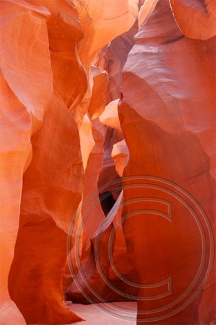
This is actually Lower Antelope Canyon. I made this photo on another trip. My passengers went to Upper Antelope Canyon, which is more accessible and looks a lot like this shot.

One of my passengers had eaten something the day before that didn’t agree with her and was feeling a bit under the weather when I picked them up. Fortunately, the symptoms had subsided by the time they went on their Antelope Canyon tour. When they returned, they were in high spirits and she was hungry for lunch. Since there was no rush getting to our next destination, I recommended a restaurant near the tour operator office and they went in for a meal. I spent the next hour doing some last-minute networking with a Hummer tour operator nearby.

By the time we got to Page Airport, it was well after 2 PM. Although winds had been forecasted out of the southwest at 20 mph, there was barely a breeze out on the ramp. We loaded up and took off uplake. We were the only aircraft out there — the radio was dead quiet.

The lake water was a mixture of glassy smooth areas punctuated with ripples caused by surface winds. Our ride, 500 to 1000 feet above the lake’s surface, was remarkably smooth. I pointed out all the buttes and bays and canyons I knew by name, then swung us past Rainbow Bridge for just about the best view you can get from the air.

From there, it was on to the Confluence of the San Juan River. We followed that arm of the lake up a bit, then turned toward No Man’s Mesa, crossed it, and descended into the valley west of Monument Valley. There are a bunch of dark red sandstone formations out there that few people ever see; an old hogan at the base of one formation provides some scale to its huge size.

N630ML Parked at Gouldings
The Goulding’s airstrip, photographed from my room at the lodge. Can you see my helicopter parked there?

We approached Monument Valley from the west and made a loop around the famous monuments on that side of the park. Then we went back for landing at Goulding’s airstrip. We spooked a herd of horses as we came in low across the runway. I set us down gently on one of the two helipads.

A van was down from the lodge before I had a chance to call. We were checked into our rooms, overlooking Monument Valley, by 4 PM local time. (The Navajo Reservation is on Daylight Savings Time; we were in Utah at that point.)

Wagon Wheel
I snapped this from the covered overlook in front of the old trading post at Goulding’s.

I took the rest of the afternoon off, shooting a few photos from the lodge property. The drawback of flying into Monument Valley is that once you get there, you’re pretty much stuck. There’s no mass transit, no rental cars, no taxis. The only way off the lodge property is to hitchhike or take a ground tour of Monument Valley Tribal Park. But there are plenty of nice views from Goulding’s Lodge, so it wasn’t difficult to get a few good shots. And everything you need is within walking distance: restaurant, shops, grocery story, gas station, laundry. So it’s not as if staying there is a hardship. It’s not.

Later that evening, I went up to the little theater on the property and saw a short video about the history of the Lodge. The night was dark and the sky was full of stars. As my fellow travelers settled down for the night, a deep silence surrounded me. In the distance, now out of sight, the ancient stone monuments loomed in the darkness.