Or fun with a camera.
Note to feed subscribers: You may not see the photos in this article in your RSS reader. That’s because of the way they’re embedded. If you like photography, I do hope you’ll take a moment to visit the site and see the photos. If you don’t, just skip it. I understand.
I was in San Francisco last week for Macworld Expo. In the old days, I used to spend every day at the show. Nowadays, I’m more interested in seeing things outside the exhibit hall. With a half day to spend on my own, I took the cable car from Market and Powell to Fisherman’s Wharf. Here are some of the photos I took that morning.
I started my day just after sunrise at the corner of Powell and Market, five or six blocks from Moscone Hall, where Macworld Expo is held each year. This is the terminus for two of San Francisco’s three cable car lines. The photo here shows one of the cable car drivers turning the car around for the trip back to Fisherman’s Wharf. Although the photo is distorted (because of that darn fisheye lens I like so much), the ground here is relatively level. They manually push the car onto the turntable and turn it, then push it back onto the main track. After paying off a homeless person for telling me that I could buy my ticket on the cable car — it was either that or buy a newspaper I didn’t want to carry — and assuring another homeless person that I didn’t need him to take a photo of me and the cable car with my camera, I climbed on board.
The cable car took off up Powell a while later with a surprising number of people on board. The corner of Market and Powell isn’t far from the BART station and apparently the cable car is a valid mode of transportation for commuters. There certainly weren’t many tourists on board at 7:30 AM. We climbed up Powell, dropping off passengers here and there. I took this photo when the car was nearly empty. Again, there’s some distortion from the fisheye lens, but I think it’s a cool shot of the cable car and its driver.
The car deposited me at Bay Street about two blocks from Fisherman’s Wharf. From there, I wandered around, taking photos of the area. The sun was too low to get the shots I wanted, so went in search of breakfast. Boudin’s Bakery was there and I stepped inside. I love freshly baked bread, but I was on a diet and trying hard to avoid excess carbs. But I did get a good photo op when I saw this “Bread Line” sign. It was just too ironic for me to pass up.
Back outside at the Wharf with the sun still too low for shadow-free photos, I asked one of the fish guys where I could get a good breakfast in a place the tourists didn’t go. He pointed up the street to a “hole in the wall” called Darren’s Cafe. While waiting for my meal, I snapped this weird self-portrait with that fisheye lense. I don’t look happy here, probably because I knew the camera was shooting a picture up my nose.
After breakfast, I strolled north along the wharf area, stopping a few times to take photos of the fishing boats. Unlike most tourists, I didn’t stick to the well-trodden places. I poked around on all the piers, taking my time and seeing as many different things from as many different angles as I could. It was a beautiful day with clear blue skies and light wind. Not very cold, either. Here are a few of my more interesting shots in that area.
After a while, I found myself in Aquatic Park, which is part of the San Francisco Maritime National Historical Park. There are a number of old, art deco buildings there and the light was just right to get creative with some shapes and shadows on a round building that used to house a public restroom. A flight of stairs curved up the side of the building to an observation deck on top. But the views from up there didn’t interest me as much as the stairs, shown here.
From the park, there were sweeping views of San Francisco Bay. But the best views were obviously from the curving arm of the Municipal Pier. So I took off on foot along the long, crumbling concrete and steel pier. The only people on the pier were a handful of Asian fisherman, although when I reached the remains of the building at the far end, another tourist pedaled up on a bicycle. We had a short chat before I walked back. Here are the photos I took along the way. They show, in order, the rust of steel embedded in the concrete, the Golden Gate Bridge, and Alcatraz.
It was nearly 10 AM by the time I got off the pier. I had to check out of my hotel by 1:30 PM, but I had a few errands to take care of on the way back. So I walked up to the cable car terminus at Hyde, which is just a few blocks away. By this time, the tourists were coming out and there was about a dozen people waiting. I snapped a series of photos of the cable car being turned. If I look at them quickly in sequence, they look like a movie. Here are five of the six shots in miniature:

On the way back to the Union Square area, I had a nice conversation with a woman who lives in San Francisco and uses the cable car to commute back and forth to work across the city. I couldn’t help but be envious. How wonderful it would be to ride in an open seat through such a beautiful city every day.


 This photo is the last one I snapped on the flight. I was flying east on Tropicana at 3000 feet MSL. Then the Alt (short for alternator) light on my panel illuminated and didn’t go out. That meant there was a pretty good chance I had an alternator failure. And if there’s one thing any pilot will tell you, it’s not a good idea to start a 2-hour flight across empty desert without an alternator.
 When you have 4+ hours to kill in coach on a Phoenix to Newark flight, you do run out of things to do. I killed some time playing with my new 10.5mm lens. Here’s a look out the window. I think we were over Kansas or maybe eastern Colorado at the time. See the checkerboards of the terrain?
 After landing at the airport and getting a much-needed shoeshine in the terminal, we made our way to the rental car area and picked up our Avis rental car. Mike then drove us right into the city, by way of the Lincoln Tunnel. This photo was taken as we made our way across town toward Times Square. Okay, so it’s not the best image. But what do you expect? The camera was sitting on the dashboard and we were stopped at a light. You can see the shadowy figure of a pedestrian crossing the street — this was a long exposure.
 Our tiny but comfortable room at the Sheraton Hotel and Towers on 52nd and 7th was on the 37th floor. From the big windows, we got a glimpse down into Times Square. I set up my tripod on the desk along the windowsill and captured this image as we settled down for our first night.
 Wondering what that view looked like in daylight? Wonder no more. Here it is. Not quite as colorful or glamorous on a gray New York day. The buildings in the foreground are all office buildings. There was a very large conference room right across the street from our room; they had a big meeting in there the day we left.
 On Tuesday we did a lot of walking. That’s the best way to get around in New York. My only wish was that I’d brought thinner socks — my heavy cotton socks aggravated my 25-year-old corns. But that’s probably more information than you need, so I’ll stop there.
 It’s Grand Central Terminal, not Grand Central Station. Many people get that wrong. It doesn’t matter. It’s Grand Central and it’s a magnificent piece of architecture on 42nd Street at Park Avenue.
 The New York City Public Library is a monument on Fifth Avenue at about 40th Street. People know it for the matched statues of reclining lions out front. But few tourists ever step inside to see how incredibly beautiful it is.
 Out back, in Bryant Park, they’d set up a skating rink. This shot, taken with that funky 10.5mm lens again, shows the rink, the back of the library, and a few of New York’s skyscrapers, including the Empire State Building. There were craft vendors set up all around the rink for the holidays.
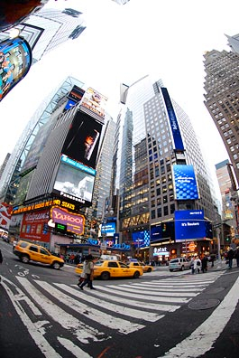 I’m convinced that the best way to take photos in a place as busy as Times Square is with a wide angle lens. Can’t get much wider than this. I know it looks funky, but it really does show a lot. And if your mind can take out weird curves — since Photoshop can’t seem to do it — you can get a real feel for what’s there.
 The above photo looks downtown. This one looks uptown. I’m standing at the divider between 7th Avenue and Broadway, between 44th and 45th Streets. I snapped quite a few shots while I was standing here. I like this one the best. The exposure isn’t very good, but that’s mostly because the light sucked on such a cloudy afternoon.