I make my annual pilgrimage to a certain software company’s headquarters.
I’ve been writing about a certain software package since 1998. The software, which I can’t mention by name in this blog entry (for a very complex set of reasons) is revised every year to add and improve features and tweak the interface so it’s easier and more intuitive to use.
Every year, I fly out to Mountain View for a day to meet with my editor and the folks at the software company. I call it my annual pilgrimage. It’s usually a pleasant day trip. The company’s campus is beautiful and tranquil, lush and green and flowery with water flowing from one small pond to the next and bridges crossing the water to the various buildings. I remember the first time I saw the place — I wished I worked there.
I usually fly out the day of the meeting and fly back the same night. It’s weird getting on the plane with just an iPod, a steno pad, and a pen for luggage, but it’s also rather nice. I really hate dragging luggage around airports. I try not to even carry a purse on trips these days.
Anyway, this year Megg, my editor, invited me to come out the evening before. Although I didn’t want to spend the extra time away from home (I’m trying to finish up the WordPress book) or the money on a hotel room, Megg offered to pick up the hotel cost and dangled the ultimate carrot in front of me: a nice sushi dinner. How could I say no?
I took an America West flight out of Sky Harbor at 4:30 PM. It was an incredibly pleasant flight — smooth, with no clouds to block my view out the window at seat 14F. (Of course, the wing was there and I did get a stiff neck twisting my head to the right to look behind it. But it was worth it.) The plane followed almost the same course I did the last time I flew to the Placerville, CA area in my helicopter and I got to see the same landmarks and small airports — but from 37,000 feet rather than 500. I knew exactly where we were on every part of the trip until we passed the Tehatchapi pass — then we flew more to the west and the Central Valley became a big patchwork of farmland out my window, bordered by the snow-capped Sierra Mountains to the east.
 We landed at Oakland. Megg had flown into the same airport — her options from Salt Lake City are not quite as numerous as mine from Phoenix — and had arrived about 30 minutes before I did. She was at the car rental place when I rang her cell phone and had just picked up Chevy’s version of a PT Cruiser. I won’t tell you what she called it; I’m not sure if it’s politically correct. (It’s one thing for me to be politically incorrect in my blog, but another to report a friend’s political incorrectness here.)
I took the car rental shuttle to meet her. It was a long ride. For a while, I thought they were taking us to the car rental location at another airport. Outside the bus, I could see the fog bank coming over the mountains that separate the bay from the ocean. San Francisco was buried in it. I could just see the top of Sutro Tower poking up through the top of the white, fluffy cloud. But in Oakland, it was beautiful and clear. It was only around 7 PM and the sun was still shining brightly. A beautiful day.
I agreed that the car was exactly what she’d called it, then tossed my small day pack into the back. I’d packed fresh socks and underwear and a clean shirt that needed ironing, along with my laptop, iPod (I listened to podcasts on the entire flight), and various power adapters and chargers. Oh, and a steno pad with a pen. That’s it. Megg had packed a large black wheelie bag the same size as the one I’d taken on my last 16-day road trip. I teased her.
We went in search of the restaurant in Mountain View. She’d scoped the whole thing out on the Internet and had the address and phone number. It didn’t matter. We got lost anyway. Not a big deal. We eventually found the place and settled down for a sushi feeding frenzy.
Megg is the only person I know who can eat more sushi than I can. We ordered quite a bit, ate it all, and then Megg wanted to order more. I felt a little as if I were in some kind of eating contest. Peer pressure to keep up. So I stuffed in a few more pieces.
By that time, it was well after 9:30. We headed out to the hotel, passing again through the town of Mountain View. The place had one restaurant after another. Indian, Japanese, seafood, eclectic American — it was all there. Someday, I’d like to come back and eat my way through the town.
I also spotted a neat bookstore to visit the next day while Megg was in another meeting.
The hotel was a Comfort Inn in Mountain View. Not a fancy place, but clean and comfortable. And free wireless Internet access. What else can you ask for?
Despite the fact that I went to bed after midnight, I was up just after 5 AM the next morning. I started this blog entry, showered, ironed my shirt, and put on some makeup. (The ironing and makeup demonstrate how important this meeting is.) Of course, I didn’t dress up. I wore my new helicopter shirt — it’s a Hawaiian shirt, made in Hawaii, no less, with helicopters instead of flowers — and a pair of white cotton drawstring pants. And my white leather Keds. You know, if you start dressing up, they start to expect it. Been there, done that.
I tried coffee from my in-room coffee maker and coffee from the complementary breakfast in the hotel lobby. I made the mistake of walking down to the lobby barefoot. I don’t think they wash the floors too often. My feet were so filthy when I got back to my room that I had to wash them before putting on my socks. None of the coffee was good.
Fortunately, Megg and I were meeting at 8:30 for breakfast. Megg had also gotten up early for her morning walk and had scoped out a place. There was a strip mall down the road that had a bagel place and a Starbucks. We hit both: bagels for food, tea (for Megg) and latte (for me) for beverages. We ate outside at a table near Starbucks. It was a pleasant day, not at all too cold for my lightweight clothing. (A good thing, because I had neglected to bring along a jacket.) We gossiped about a certain computer book author who is incredibly full of himself, has alienated himself from all other authors, is difficult for editors to work with, and manages to make tons of money.
We went to our meeting. It went well. Alas, no details can be provided. And I forgot to bring along my camera to take a snapshot of that beautiful campus.
We drove back to the town of Mountain View for smoothies. Megg left me; she had a second meeting to attend. I’d have about 2-1/2 hours to kill in Mountain View.
Unfortunately, I was still full from breakfast.
 I walked down one side of the street and up the other, peeking into shops and even stepping into one or two. One was a place called Seascapes — a place you can buy exotic tropical and saltwater fish, as well as various reptiles. They had a big fish tank right near the entrance with a huge fish in it. I walked up to the tank and looked at the fish. He looked back at me. I took a step to the left. He swam a few inches toward me. I took a step to the right. His eyes shifted. He was definitely watching me. I also got a chance to see a pair of $1,400 turtles. They lived in a plastic kiddie pool and didn’t seem nearly as active as the doorman fish.
 The restaurants in Mountain View had outdoor dining. They accomplished this by blocking off parking spaces along the curb with potted plants and putting out tables and chairs. When you walked down the sidewalk, you walked right through the middle of the restaurant. Most of the restaurants were quite busy — it was lunch hour, after all. The food looked great.
On the other side of the street, I went into the bookstore I’d spotted the night before. It was a great independent bookstore called Books, Inc. with locations in seven California cities. There was a nice sized selling floor with books and a sort of balcony above with a cafe. Of course, I still wasn’t hungry.
I spent an hour in the store, looking at all the shelves. I wasn’t surprised to see that they didn’t sell computer books. How could they? Computer books have short shelf lives and are difficult to keep up with. If I had a bookstore, I wouldn’t sell them either. And I write them.
I chose two books and went to the front to pay for them. The front counter had the all-too-usual collection of DaVinci Code rip-off products. In this case, it was a screenplay with photos and a handful of books debating whether there were any facts in the book. It amazes me that publishers have to latch on to something they know is successful for another publisher to suck revenue out of it for themselves. It’s the whole copycat thing. (I’ll talk about this trend and my new take on the DaVinci Code in another entry.) I asked the woman at the counter if she was sick of the DaVinci Code. She told me she was.
I picked up two bookstore newsletters on my way out and continued walking. There was another bookstore next door — it appeared to sell a lot of used books — and they had 2006 calendars in front. Half price — heck, I thought they should be 1/4 price since it was already almost June. I never did get my helicopter calendar and thought I’d go in and try to find one. But when I stepped inside, the Gestapo representative at the counter told me he had to check my bag. Jeez. I didn’t think anyplace did that anymore. I thought cameras handed shoplifting surveillance. And I didn’t like the idea of being thought of as a potential shoplifter. So I took my bag and left.
I walked all the way to the end of town, crossed the street, and started back. Along the way, I’d crossed a few streets, each of which had a crosswalk and the California version of the Walk/Don’t Walk sign. Evidently, these signs are highly respected in California; other walkers would wait at the corner, even if there wasn’t another car in sight, until that walking man symbol appeared. I didn’t. New Yorkers use Walk/Don’t Walk signs as advisories. When it says Walk, it’s more likely to be safer to cross than when it says Don’t Walk. That doesn’t mean it’s safe — just possibly safer. And Don’t Walk doesn’t really mean not to do it. It means that doing it might be a bit risky. But heck, life in New York is risky, so if you think you can do it, go for it.
Mike’s cousin Ricky told us that he got a ticket for jaywalking right after he moved from New York to Seattle. He thought the cop was kidding. I would have, too. And I would have asked him why he didn’t have more important “protect and serve” things to do than bug pedestrians.
Of course in Arizona, if there’s a crosswalk and you step into it — even with a dozen cars speeding towards you — the cars have to stop so you can cross. They get a ticket if they don’t. I don’t think this is a good idea at all. It teaches pedestrians — including their children — that it’s okay to step out in front of moving traffic. Doing that in New York is actually a method of suicide.
I finished my loop, ending up where I’d started at the smoothie place, at 1:30. I still had 1-1/2 hours to kill.
I felt like a little bite to eat. There was a restaurant nearby and it had outdoor seating. I got a table and looked at the menu. Cuban food. I ordered an ahi ceviche dish and an iced tea and settled down to read the two newsletters I’d picked up in the bookstore.
It was the perfect snack. The raw marinated ahi was mixed with wasabi, diced apples, watercress, slaw (a fancy way to say cabbage, it appears), and other mystery ingredients. Every mouthful was a combination of interesting flavors. And the appetizer sized portion was small, the food was light. Just enough food to hold me over in case I didn’t get dinner at the airport or on the plane.
I found a book in the newsletter that I wanted to buy, so that gave me an excuse to go back to the bookstore. I headed over there and, just as I was about to go in, got a call from Megg. She was on her way back. I told her where I’d be and went into to get the book. But it was a new title and hadn’t arrived yet. I emerged without it just as Megg pulled up.
We headed out to the airport. My flight was at 6:23; hers was at 6:30. It was 3 PM. Oakland airport was about an hour away. Megg got a chance to relive some of her Bay Area traffic experiences.
After returning the car, getting to the terminal, and going through security, we found a table at the bar and ordered drinks. I insisted on buying. We chatted and I actually paid $9.95 for an hour’s worth of Internet access (I really don’t like paying for wireless access when I’m traveling) so I could show her my blog projects. She sent some e-mail, I checked mine and sent some, too. She bought the next round. Someone who works for Peachpit Press took a nearby table, recognized me, and handed me her card.
We had some Round Table Pizza for dinner. It tasted good, but had way more crust than topping. I like thick crust pizza, but this was almost thick enough to be considered “Sicilian” style.
We went our separate ways at 6 PM. My flight was already boarding. It was a regional jet with a flight attendant who may have gotten her sense of humor at Southwest Airlines. Or maybe she was practicing for them. Very entertaining.
We flew through clouds for the first half hour of the flight. Then the clouds started to break up and I could see the barren Nevada desert below us. We flew almost due east, then turned to the south. I saw Lake Mead and the west end of the Grand Canyon, then I-40 and I-17. We flew right over Lake Pleasant, got into some kind of traffic pattern, and landed at the airport. We were 20 minutes early and lucky to get a gate.
I drove home with the top down in the Honda. I’d parked it in one of the east parking garages and it was relatively cool in there, but it was hot out on Phoenix’s asphalt. The hot air reached out to me with thick fingers that the car’s air conditioner kept chasing off. The farther north I got on I-17, the cooler it got. I stopped for fuel on Carefree Highway, then headed west. By 9:45, when I rolled into to Wickenburg, it was a cool spring evening back in the desert.
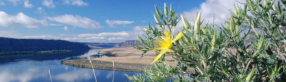
 I was immediately struck by the beauty of Stanley. It was a nice, small town with the Salmon River running through it. The Sawtooth Mountains bordered the area to the southwest, the direction I’d come from.
 We landed at Oakland. Megg had flown into the same airport — her options from Salt Lake City are not quite as numerous as mine from Phoenix — and had arrived about 30 minutes before I did. She was at the car rental place when I rang her cell phone and had just picked up Chevy’s version of a PT Cruiser. I won’t tell you what she called it; I’m not sure if it’s politically correct. (It’s one thing for me to be politically incorrect in my blog, but another to report a friend’s political incorrectness here.)
 I walked down one side of the street and up the other, peeking into shops and even stepping into one or two. One was a place called Seascapes — a place you can buy exotic tropical and saltwater fish, as well as various reptiles. They had a big fish tank right near the entrance with a huge fish in it. I walked up to the tank and looked at the fish. He looked back at me. I took a step to the left. He swam a few inches toward me. I took a step to the right. His eyes shifted. He was definitely watching me. I also got a chance to see a pair of $1,400 turtles. They lived in a plastic kiddie pool and didn’t seem nearly as active as the doorman fish.
 The restaurants in Mountain View had outdoor dining. They accomplished this by blocking off parking spaces along the curb with potted plants and putting out tables and chairs. When you walked down the sidewalk, you walked right through the middle of the restaurant. Most of the restaurants were quite busy — it was lunch hour, after all. The food looked great.
 Lynn got me settled in and we had some wine by one of the two creeks that flowed past her house. Then we went for a walk in her alfalfa field. This is the view from the end of the field, looking back toward her house.
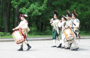 The first treat was the re-enactment stuff going on. I don’t know if they do this every Sunday or if we just happened to stop by on the right day, but there were men in revolutionary war uniforms doing the kinds of things the soldiers did back then. Like marching around with a drum and fife. Or with guns. Or setting up a camp near the mortar lobbing area. Or building a shelter without any modern tools.
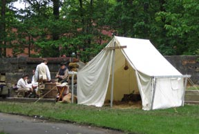 I don’t know why these guys were there, but they were definitely into it. Their outfits looked great — but a lot cleaner than they would have been 230 years ago. Sadly, there weren’t many spectators. The park was pretty empty. It was as if they were performing for themselves. Maybe something was going to start later on. We didn’t hang around. We had dim sum to eat.
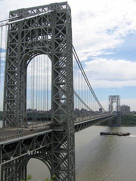 We also spent some time at one of the lookouts, watching the bridge and the river flowing beneath it. I took some pictures (of course). And I can recall some of the facts that I’d read about the bridge while in my hotel room.
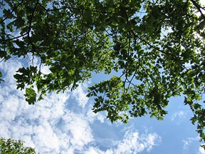 Anyway, I also took some time to lay back on the bench and look up at the sky through the leaves of an oak tree. It was nice to be among trees that were a good deal taller than I am. The area is lush with vegetation, like a jungle waiting to reclaim the land.
 But Sunday I was there.