I can’t deal with people like this. Can you?
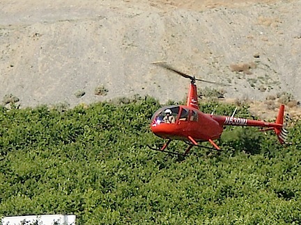
Here’s a photo of me in action over a cherry orchard in 2010.
As many people know, I now make most of my income in the summer doing agricultural work in Washington state with my helicopter.
Each year, my client base has minor changes, adding and removing acreage. It’s gotten to the point, however, that I usually need a second helicopter to help me during a one-month “crunch” period that runs roughly from the third week in June to the third week in July.
As I prepared to start my search for another helicopter with pilot, I was very pleased to get the following message via the contact form on Flying M Air‘s website:
Hello,
I was just wondering if you might know of a farmer who wants a helicopter for the upcoming season that you are unable to take care of? I have several helicopters available and have been doing frost abatement and cherry drying for over 5 years now.
An experienced guy with several helicopters? It sounded too good to be true. I replied:
I am looking for an experienced pilot with a helicopter for one month in the Wenatchee area. It would start around the end of June and run until the end of July. If you’re interested please give me a call.
He called. We spoke. He told me he had five helicopters: a JetRanger, a LongRanger, an R44, a Hiller, and an Enstrom. I told him I was interested in the R44 but only if the pilot had at least 500 hours in helicopters and 50 hours or more in the R44. He said all his pilots had over 1,000 hours.
At this point, a little nagging voice should have been whispering in my ear: This can’t be real. If this guy is experienced and has five helicopters, why doesn’t he already have contracts, especially for the R44, which would be anyone’s first choice of aircraft?
But if that little voice was talking, it may have been whispering. And since my brain is so caught up in divorce bullshit these days, I didn’t hear it.
Instead, I enthusiastically made him an offer for the R44, which he enthusiastically accepted. I told him I’d send a contract so he understood the terms and that I’d be able to give him more accurate dates in about a month. When we hung up, I remember thinking: Well, that’s one less thing to worry about. I even told a friend I’d already found a pilot to help me.
A week went by. I did some traveling. I didn’t get a chance to send the sample contract. There really wasn’t a rush; the work was still more than three months away.
I got another email message from the operator:
It was nice talking with you last week and thank you for the opportunity to work on cherries together in WA. Since our conversation I have had a chance to look a little closer at he numbers for an R44 and it looks like the lowest daily rate I can work with is $XXX per day but the $XXX per hour is the hourly rate needed so you were right on the mark with it. If you can’t do that as a daily rate I understand but I do have an Enstrom that I can get you for $XXX per day and only $XXX per hour.
I don’t want to give exact numbers here; I like to keep contract terms between me and the people I work with/for. He was telling me he needed $50 more per day for the R44 but only $25 more per day for an Enstrom, which I didn’t want. He could save me $25/hour of flight time on the Enstrom. So if I wanted the R44, it would cost me $1,500 more. Since my clients weren’t paying me that much, I’d lose money every day.
Classic bait and switch.
To say I was pissed is an understatement. I don’t like to be played. I know what it costs to own and operate an R44 and I know my offer was right in line with the going rate. So I replied honestly and politely:
Thanks for letting me know your requirements. I’m not sure I’ll be able to collect enough money from my clients to fill your needs. I’ll keep looking for someone else to handle the contracts for me. I don’t think the Enstrom will do the job. I’ll be in touch either way.
A few days went by. I got to talking to a friend of mine who also does cherry drying. He told me he’d been contacted by an operator who wanted to hire him and his Hiller to dry cherries in my area this summer. He told me that he was having a problem with the contract terms this guy was offering. Although the money was okay, this guy wouldn’t pay until after the grower had paid him. So my friend would be providing services with no guarantee of being paid if the guy who hired him didn’t collect.
You know what’s coming, right?
The guy who called my friend to hire him to fly was the same guy who had contacted me looking for work. He was acting as a broker — a middleman. He needed me to pay him more so he could pay the going rate to the guys who would fly for him and pocket money on the side. He wasn’t providing the services with his helicopters or his pilots.
A day or two later, I started writing a nasty email to him, but wisely deleted it.
Another week went by. Yesterday, I got this email from him:
I was just wondering if you have been able to find another 44 yet? If not can you do $XXX per day?
He was still looking for work for that R44, but now he’d dropped the daily rate to just $25/day more than I was offering. In all honesty, I could have made that work. But by then, I knew that I couldn’t trust him. And I didn’t want to work with someone I couldn’t trust.
Here’s where I’m different from most people. If you do something what bothers me, I will tell you about it. I want people to understand where I’m coming from. I’m not going to sneak around behind people’s backs and pretend everything is A-OK when it’s not. So I sent this message and BCCed it to my friend:
In all honesty, I’m not happy with the way you accepted my terms on the phone and then said you had to have more. I’m also not happy that you said that YOU owned the helicopters and I later found out that you tried to hire another pilot to cover cherry contracts for you. I’m thinking that you don’t have enough helicopters to cover your contracts or that you are trying to be a middleman. I’m also thinking that you’re not being entirely straight with me. I am not interested in working with someone I can’t trust. My clients are extremely important to me and I need to feel comfortable with the service I’m providing.
So I’m thinking that its best that we don’t work together this season. Sorry.
Too blunt? Probably. But that’s the way I am. I call it the way I see it.
It was obviously too blunt for him. He fired back:
Ok, so I never said it would actually work I said it may work on the phone. I never said I owned the helicopters, I have been doing this for over five years and have quite a few of my own contracts. I work with several other companies who are very happy with the service I provide. I never misrepresented what I do, just because you assume something doesn’t mean I said it or implied it. As far as being the middle man what are you doing?
Sorry, but I don’t agree with this. On the phone, he made it sound as if he had five helicopters. He even listed the models and told me all his pilots had 1,000 hours. And yes, he did say that the terms I offered would work — why else would I feel as if the job of finding another aircraft was done? I don’t have a recording of the conversation and I don’t have any notes. But I know what I heard and I know I was misled.
I replied:
I am not a middleman. These are my clients. I fly the contracts too. You misled me in our discussion and now you’re making excuses. I don’t deal with people I can’t trust.
And that’s when he showed his true colors:
ok, I should have listened to what people say about you but I thought I would give you a chance.
Yep. What kind of responsible business person makes a crack like that? Not only did he just slam the door on working with me in the future on cherries or frost (or anything else), but if any the other operators I routinely work with ask about him, I’ll tell them about this.
What should he have done? Well, he should have been a little bit apologetic, perhaps saying that he was sorry that he didn’t make the situation clear or sorry that I misunderstood him. He could have offered to start over with a more truthful account of his setup. But instead, he chose to take the line that I was at fault and that he should have known better to work with me after what he’d heard about me.
As if I give a shit what he and others say about me behind my back.
And him give me a chance? Jeez. How out of touch with reality is this guy? Aren’t I the one offering the work? The way I see it, I’d be giving him a chance.
Which, of course, I would now never do.
I got a call from my friend this morning. He had read the exchanges between me and the other guy. We chatted some more about this guy. Some details emerged. He had a helicopter last season and crashed it on a cherry contract. He apparently doesn’t currently have any helicopters at all. The deal he offered my friend for frost work required my friend to fly a certain number of hours for free or pay him for hours not flown. My friend would have lost money this season — especially since there was no frost flying to be done due to unseasonably warm weather all spring. He was glad he didn’t take the deal. And after our talk, he likely won’t be doing any deal with this guy in the future.
Sadly, this isn’t an isolated case. This business is highly competitive. People will say anything they need to in order to get a contract. They’ll promise the world. But when it comes time to deliver, they fall short.
Like the guy last season who said he’d work for me and seemed satisfied with the contract terms, but refused to sign a contract and refused to prove he had liability insurance. Needless to say, I didn’t work with him, either.
This isn’t a game. It’s business.
Oh, and if you feel like spending a month making good money with an R44 helicopter this summer, check this out. The only catch: you have to bring the helicopter.