Heat’s not enough. I want humidity and rain, too.
This morning, when I woke at 5:30 AM to the whistles of my parrot, I was surprised to see that Mike hadn’t opened the French door between our bedroom and the upstairs patio. He always opens it during the night this time of year. That’s the only time it’s cool.
But when I opened it, I realized why: it wasn’t cool. For the first time this season, the outside temperature remained in the 80s overnight. And that’s the first sign of what everyone in Arizona is waiting for this time of year: monsoon season.
A Monsoon? In the Desert?
Sure. I can’t make this stuff up.
Monsoon season in Arizona is marked by a number of meteorological events:
- Dew point reaches at least 55°F for at least three days in a row. That’s the official indicator of the start of monsoon season in Phoenix. That means it gets humid outside. The “dry heat” isn’t so dry anymore.
- The winds shift to bring moist air off the Sea of Cortez and Gulf of Mexico in a counterclockwise flow. This is why the storms, when they come to Wickenburg, come from the north or east during monsoon season.
 Storms build just about every afternoon. I can see them coming from my office window. (You can check out the WebCam image here; it’s usually available during daylight hours.) They’re isolated, severe thunderstorms, packed with high wind, lightning, and the occasional microburst.
- It rains. That’s if we’re lucky. The clouds have lots of moisture, but if the ground is too dry, the rain dries up before it hits the ground, resulting in virga and, often, dust storms. But once monsoon season is underway, we get rain — although never enough of it to quench the thirst of our golf courses and swimming pools.
- We get flash floods. That’s if we get enough rain all at once. A dry wash runs through our property and, with enough rain, it can turn into a raging river. For about an hour. Then it’s just a wet riverbed that, within 24 hours, turns dry again.
Want more info, you can get it here, here, and here.
And this is what most Arizonans are waiting for.
My Monsoons
I’ve experienced Arizona monsoons in three different places over the years.
Wickenburg
I’ve lived in Wickenburg for ten years now, and although I’ve been wanting to escape, like the snowbirds, in the summertime, I haven’t usually been able to. That means I’ve lived through a good bunch of monsoon seasons.
My office has always faced the mountains to the north (even when it was in a condo I own downtown). I’d be sitting at my desk, working away, occasionally glancing up out the window. I’d see the storm clouds building over the Bradshaw and Weaver Mountains, making their way southwest toward Wickenburg. The sky would get dark out there — while it remained sunny at my house — and lightning would flash. If the storm reached us before sunset, we were in for it. But in too many instances, the storm was just too slow and got to us after the sun set. Then it was a 50-50 chance that we’d get some storm activity — including welcome rain — before the storm dissipated.
Sometimes, the storms moved in more quickly — probably more moisture in the air. In those cases, we’d get a storm in the afternoon. What a treat! I’d stand under the overhang by my front door or on the patio at the condo and listen to the rain fall. Sometimes, if it looked rainy enough to get the washes flowing, I’d jump in my Jeep and head out into the desert, looking for a stream where streams don’t normally appear. I don’t drive through these — mind you — that’s dangerous. I just watch all that flowing water, remembering what it was like to live in a place where flowing water is a lot more common than dry streambeds.
On very rare occasions, a storm would move in just before dawn. I can’t remember this happening more than a few times, though. One time, it was the morning I was supposed to report back for work at the Grand Canyon, where I was flying helicopter tours. I had planned to take my helicopter up — the 1-1/2 hour flight sure beat the 3-1/2 hour drive. But with a thunderstorm sitting on top of Wickenburg, flying up was not a safe option. So I had to drive. I left two hours earlier than I would have and still got to work an hour late.
If you want to read more about the monsoon in Wickenburg, I recommend Lee Pearson’s excellent article for wickenburg-az.com, “The Monsoon Is Near“. It includes links to video footage he’s made available online.
Grand Canyon
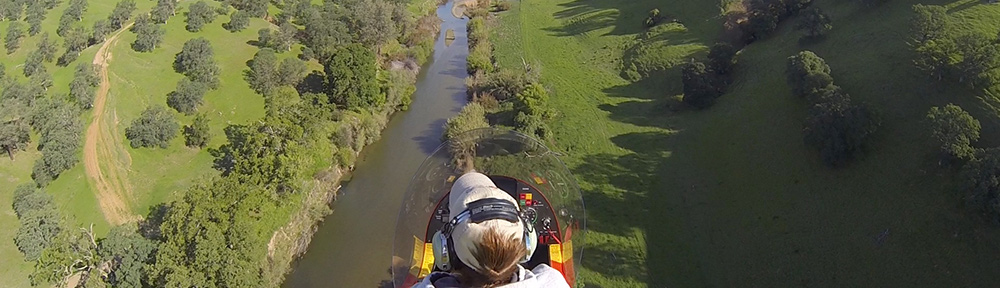
In the summer of 2004, I worked as tour pilot at the Grand Canyon. I flew Long Ranger helicopters over the canyon 10 to 14 times a day on a 7 on/7 off schedule from April through the end of September.
My introduction to monsoon season came on my return from a flight in July. The storms had built up and were moving in toward the airport. I was about 5 miles out when a bolt of lightning came out of the sky less than 1/4 mile from where I was flying and struck the top of a Ponderosa pine tree. The treetop exploded into flames. I got on the radio, on our company frequency, and said, “It’s lightning out here. It just hit a tree about a quarter mile away from me.” The Chief Pilot’s voice came on and said, “Better get used to it.”
When you learn to fly, they teach you the danger of flying near thunderstorms. They advise you to stay at least 20 miles away. 20 miles! So you can imagine my surprise when I realized that the tour company had no qualms about continuing flight in the vicinity of thunderstorms.
And they were right — it didn’t seem to be dangerous at all. The storms were all localized — you could see them coming and usually fly around them if they were in your way. The rule we used was that if you could see through the rain, you could fly through it. Although it occasionally got a little bumpy, there were no serious updrafts or downdrafts. And although we were told that if things ever got too rough during a flight, we could land until the storm passed, I never had to. (Thus passing up my only opportunity to legally land a helicopter inside the Grand Canyon.)
 I do recall one other monsoon-related incident, though. The company I worked for had about ten helicopters on duty to do flights. Because of this, the company was very popular with tour companies, which would bus large groups of foreign tourists to the airport for helicopter flights. These flights were booked years in advance, so the company always knew when they’d need all helicopters to fly for a single group. One of these groups arrived late in the day during August. Nine other pilots and I were sitting out on our helipads, engines running, blades spinning, when the bus pulled up. Moments later, the loaders were bringing groups of five and six Japanese tourists to the helipads and loading us up.
It had been stormy most of the afternoon, with isolated thunderstorms drifting across the canyon. Farther out to the east, a controlled burn was sending low clouds of smoke our way. At the airport, however, the visibility was fine. We were scheduled to do a tour on the west side of the canyon, in the Dragon Corridor. One by one, we took off and headed west, making a long line of ten helicopters, all going the same way.
I was about six back from the front and could see we had a problem about five miles short of the rim. The north end of the Dragon Corridor was completely socked in with low clouds and falling rain. We couldn’t see across the canyon.
The lead helicopter announced on the company frequency that he was going to switch to an east canyon tour. He made a 180° turn. One by one, we all announced the same intentions and followed him. Now we were all heading back to the airport. We got permission from the tower to transition to the east, crossed about 1/2 mile south of the airport, and continued on.
Now we were in the smokey area. It wasn’t bad. Not yet, anyway. We crossed over the canyon and my passengers let out the usual oohs and ahs. And we proceeded to do the east canyon tour, which was reserved for weather situations because it normally ran about 35 minutes (and our passengers paid for a 25 minute tour). Of course, with the initial false start, their tours would be 45 minutes long.
The thing about flying at the Grand Canyon is that you have to stay on established routes. The only time I’d ever done that route was in training four months before, so I really wasn’t too clear on where I was supposed to go. Fortunately, there was a helicopter about 1/2 mile in front of me to follow. Unfortunately, the weather was closing in. It started to rain and visibility got tough. I focused on the other helicopter’s strobe light and followed it back across the canyon to the rim. Then I lost it in the smoke.
I pointed the helicopter in the direction I thought the airport might be and flew as if I knew where I was going. About a mile out, I saw the tower and other landmarks. I was only about a half mile off course. I landed safely, my passengers got out, and I shut down for the day.
I used to ask the Chief Pilot why we flew scenic tours in weather like that. His response: “If they’re willing to pay for it and it’s safe, why not?”
Howard Mesa
Howard Mesa is a mesa north of Williams and south of the Grand Canyon. It stands 300 feet above the Colorado Plateau. Our vacation property, with its camping shed, is at the very top of the mesa, with 360° views stretching out for 50 to 100 miles, depending on sky and dust conditions.
In the summer of 2005, I spent about a month at Howard Mesa, preparing our camping shed for its future duties. I lived in our old horse trailer with living quarters, a cramped space that was fine for one person, a dog, and a parrot. Mike came up on weekends to help out and escape Wickenburg’s heat.
Monsoon season atop Howard Mesa is a real treat. The clouds start building at around 11 AM and, because you can see in every direction, you can monitor their progress as they move across the desert. By 1 or 2 PM (at the latest), you can see rain (or virga) falling somewhere. This is where you can really get an idea of the individual storms because you can see them all, individually. I took this shot one afternoon around sunset. The view is out to the northwest. The mountain you see in silhouette is Mount Trumbull on the Arizona strip, 80+ miles away.

The great thing about the monsoon up north is that when the rain comes, the temperature drops at least 20°F. I remember one day doing some work around our place in the morning. The temperature was in the 90s, which is pretty hot for up there. I was wearing a pair of gym shorts and a tank top. I hopped in the truck and drove down to Williams to do some laundry and shopping. While I was there, a storm moved in. In minutes, the temperature dropped down to the 50s. Needless to say, I nearly froze my butt off.
Of course, there’s also hail up there. Some friends of mine were on top Bill Williams Mountain south of Williams one summer day when a storm moved in. The golf ball-sized hail that fell did some serious damage to their car. And the fear of hail like that is what keeps me from leaving my helicopter at Howard Mesa, unprotected in the summertime. Rotor blades cost $48K a pair.
This Year’s Monsoon
Anyway, it looks like this weekend might be the start of the 2007 Monsoon Season here in Arizona. I’m hoping for lots and lots of rain — we really need it. And I’ll try to share some photos throughout the season. Sadly, I think all my old monsoon season photos were lost in my big hard disk crash earlier this year.
 Although I did fly into this spot and I did sleep in this tent the night before, I didn’t sleep in this tent where it’s shown in the photo. I moved the tent to take the photo. With a dome tent like this, it’s easy. Just empty it out, pick it up, and put it where you want it. The helicopter was in such a pretty spot and the early morning sunlight make it look really beautiful. Why not take advantage of the light?
 I’m a strong believer in networking as a way to build strong relationships with clients, customers, and colleagues. I’ve had some success with it, which is probably why I think it’s such a good thing.
 In May 2006, a
 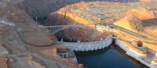 Last year my husband Mike came along for the ferry flight to Page. We stayed two nights — I fly only around sunrise and late afternoon for my clients on this gig — and departed early the next morning for Wickenburg. That’s when Mike took this shot of the Glen Canyon Dam with the morning sun casting shadows in the canyon.
 The lake is highly controversial. The dam flooded a huge area of pristine canyon lands with many archeological sites and even a few active settlements. This land was mostly inaccessible, like so much of America’s desert wilderness. That may be why the decision to build the dam was made. Although the Sierra Club would like nothing more than to destroy the dam and drain the lake, at this point I think it’s too late. The canyon walls are stained with minerals from the water and all plant life beneath the current water level is dead. It would take hundreds, if not thousands, of years for the area to be restored to its original health and beauty. Sadly, the need for water in the desert southwest has become more important than the need for another remote wilderness. We should be thankful that the original plan to stretch a dam across the Grand Canyon was scrapped, as we could have lost that instead.
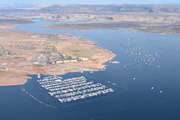 I think we should be satisfied with the beauty of the lake and the recreational opportunities it provides. Although most boating activity goes on in the Page area, there’s nothing so peaceful or relaxing as climbing aboard a houseboat for a week-long trip up lake, where few day-trippers venture. Exploring the side canyons by small boat or on foot gives you a sense of what it might have been like before the waters rose.
 I do recall one other monsoon-related incident, though. The company I worked for had about ten helicopters on duty to do flights. Because of this, the company was very popular with tour companies, which would bus large groups of foreign tourists to the airport for helicopter flights. These flights were booked years in advance, so the company always knew when they’d need all helicopters to fly for a single group. One of these groups arrived late in the day during August. Nine other pilots and I were sitting out on our helipads, engines running, blades spinning, when the bus pulled up. Moments later, the loaders were bringing groups of five and six Japanese tourists to the helipads and loading us up.