Getting hot, tired, and stinky.
The original plan, when I left the house with Jack the Dog this morning, was to go to the airport and wash the helicopter before it got too hot out.
Immediately Sidetracked
It was about 8 AM when I left the house. I stopped off at the supermarket to buy a case of bottled water for the hangar. I store the water in the fridge and bring it on trips for my passengers. I bought Arrowhead because it’s spring water (not from a “municipal source”) and tastes pretty good to me.
At the airport, I swung past the high rent district. That’s our pet name for the newer hangars on the northeast end of the developed area. (Our hangar is in the originally, low-rent district.) I was pleasantly surprised to find quite a few people out: Ivan and Shelley, Dave and his friend (who turned out to be my accountant’s son), and Ray and his mechanic.
Dave is renting space for his Hughes 500C in John’s big hangar while John has his Commander in Colorado, where he’s smart (and rich) enough to live in the summer time. I pulled up alongside the open hangar door.
“Going out?” I asked.
“Yeah. I haven’t flown in a month. I got get the dust off it first.”
“Where are you heading?”
“Well, there’s a narrow canyon with a creek in it up around Hillside. I think there’s a place to land down in there. You want to come?”
I did and told him so. But then Jack and I went to chat with Ivan while Dave dusted his helicopter. And I started thinking that I really should just wash the helicopter.
Meanwhile, Dave and his friend pushed the helicopter out and we closing the hangar door. “Is Ray going, too?” I asked.
Dave told me he might, but not right away. He had some things to iron out with his mechanic. And they were thinking of going to the Weaver cabins instead. The raspberries should be ready for picking.
I told him that I might meet them there. Then Jack and I got back into the Jeep and headed to our hangar where my dusty helicopter waited.
Heli Outings, the Wickenburg Way
I should mention something here. When we go on helicopter outings, we each take our own helicopter. Even though we each have four seats and we seldom have more than one companion, we still all climb into separate aircraft. It’s worse when there’s only one of us in each helicopter.
Dave tells a story about when he, Ray, and Jim explored a plane crash site out in the desert, “Yeah, we burned 90 gallons an hour to get three guys out there.”
In our hangar, I had to make a decision. Go or not go? And if I go, what do I do with Jack the Dog?
I decided to go and to bring Jack the Dog with me. After all, he’d earned his wings over a year before and had flown twice in the helicopter.
I loaded up my little cooler with three bottles of water and an ice pack from the fridge. Then I got Jack’s harness and the saddle blanket we use to protect the back seats when he’s in there. He trotted alongside the golf cart as I wheeled the helicopter out to the fuel pumps.
Meanwhile, Dave had started up his helicopter and hover-taxied to the fuel island. He was shutting down as we approached. The fuel guy came out as I was removing the wheels and I told him to top off both tanks. I had a flight to Meteor Crater at 6 AM the next day and I didn’t want to worry about fueling in the dark.
While he fueled, I tried to put the harness on Jack, got it on sideways, and spread the blanket on the back seats. I patted the seat and he jumped in. Then I fastened his harness to the seatbelt. It was the first time I was flying with Jack without another human on board and I didn’t want him getting excited and jumping into the front seat area. Especially since my door was off.
Ray had pulled his helicopter out of his hangar on its dolly and left it parked on the other end of the ramp. As I started up, he fired his up, too. And Dave started up.
A typical summer Sunday afternoon at Wickenburg’s otherwise dead airport: three helicopters starting up on the ramp.
The Weaver Cabins
Dave made a radio call and took off to the north. Ray hovered over to the taxiway without making a radio call. I didn’t know what he was up to.
“You going, Ray?” I asked.
“No, you go on,” he said. I realized he was still working on things with his mechanic.
I made my call and took off after Dave. Of course, I’d lost sight of him. He had a two minute head start and was flying a dark colored helicopter. I knew he’d be flying low — he and Ray always do — so I figured I’d just stay high. I was approaching Round Mountain near Box Canyon when I tuned into the air-to-air frequency we’d chosen.
“Dave, you up?”
“Yeah. Can you hear me?”
“Yeah,” I relied. “Where are you?”
He told me he was just flying over Ray’s gravel pit, which was out to my left. I couldn’t see him, but I stayed high.
I caught sight of him a few minutes later. “I got you,” I said. “I’ll pull in behind you.”
A few weeks ago, there was a midair collision in Phoenix with two news helicopters crashing into a park. All four people in the two aircraft died. Local helicopter pilots are still pretty shook up over this. I wasn’t flying with anyone unless I could see him.
I dropped down to Dave’s altitude, which was only a few hundred feet off the desert floor. I saw a lot of cows. In the back, Jack was standing up, leaning against the back wall behind the seats. Putting dog hair on the fabric there, I knew.
Dave overflew the ghost town of Octave and then started climbing up the canyon beyond it. I followed. We had a 2,500 foot elevation gain ahead of us to cross over the mountains. Dave took it close to the ground, following the earth up. I flew more conservatively, climbing to maintain a reasonable elevation over the terrain. At one point, my climb rate was 1,000 feet per minute. I realized I was catching up with Dave and reduced power.
Over the mountain, Dave did a pushover into the valley. I can’t do pushovers in my helicopter. Well, not aggressive ones, anyway. No low-G operations permitted. So I dumped the collective and glided down behind him.
Now I’ve been to the cabins about a half dozen times and I’ve always landed in the same spot — a flat spot on the arm of a mountain about 1/10 mile from the cabins. The last time I was there, I set up a line of white rock to mark the spot. But it was also in my GPS. Dave headed toward my spot, then looked as if he was going to land a bit to the east of it. So I moved toward my spot. That’s when Dave realized he had the wrong landing zone and I realized that my landing zone and Dave’s were the same. So I turned 90° and landed on the very edge of my spot, right beside some cacti and bushes where the arm of the mountain drops off. He found a flat spot about 75 feet behind me.
 A while later, we were down in a canyon beside a spring-fed creek. Flies were biting. We checked out the condition of the larger cabin, then examined the raspberry bushes. We were at least two weeks too late.
It was cool and pleasant in the shade, despite the bugs. I wished I worn long, lightweight pants and hiking shoes. At least I had water.
Jack was having a ball, running around and checking everything out.
We heard an approaching helicopter, then saw Ray circling above the trees. We walked out where he could see us. Although he normally lands in a clearing on the other side of the creek, he found a spot near us. We were back by the helicopters when he shut down. I snapped this photo with my Treo for my TumbleLog. That’s Ray’s Hughes 500D on the right and Daves Hughes 500C on the left with my big fat tail (take it anyway you want) in the foreground.
Ray had two passengers with him and he took them down to see the cabins. He told us that there was a fig tree in a clearing upstream. Figs, of course, are in season right now and everyone loves fresh figs. I still don’t know if he was bullshitting us, but we never found the fig tree and he wouldn’t walk upstream to show us where it was.
On to the Canyon
Dave decided to continue on to his first destination, which was the canyon up near Hillside. One by one, we started off and took off. Ray went first — he wanted to be off the ground before I brought my RPM up to 100% and blew dust into his cockpit. (Both guys fly with all doors off most of the year; I only had one door off because I’ve been flying passengers lately.) Then I went. Then Dave. Ray disappeared quickly. I followed Dave over another mountain and northwest toward Hillside.
I watched Dave fly from my perch about 200 feet above him and 1/4 mile back. He flew close to the ground, following the earth. He’d climb over a small hill and drop down on the other side. I either flew around the little hills or glided over them. I lost him when he reached the boulders west of Hillside, then picked him up again when he climbed into sight for me.
Then he was turning, following a canyon, dropping down even lower.
“Yeah, there isn’t enough room for both of us there,” Dave said into the radio. I looked down and saw Ray parked alongside a stream in the bottom of the canyon.
“Jeez, Ray, there’s barely enough room down there for one.”
“Oh, it’s not that tight,” he told me.
Dave turned and went back downstream. I lost sight of him for a moment, then saw him on a sandbar about 1/4 mile downstream from Ray.
“There’s another sandbar right in front of me,” he told me. “I think there’s room for you.”
But in all honesty the location didn’t seem very appealing to me. It was in full sun and there wasn’t much water flowing. I was wearing Keds, which don’t make very good hiking shoes. And although those guys have more rotor blades than I do, mine are almost twice as long. I needed a good, big spot. I probably could have found one, but I didn’t think it was worth the effort.
Besides, I’d gone to the airport to wash my helicopter and I still had some work waiting for me back in my office.
“I think I’ll just head back,” I told him.
“Are you sure?” Dave asked.
“Yeah. I got work to do. Have fun. Fly safe.”
Ray was still on the radio. “Dave, you on the ground?”
But Dave had either turned off his radio or, more likely, the signal was blocked in the rocky canyon. “He’s on the ground,” I reported. “About a quarter mile downstream. I’ll see you guys later.”
I climbed out and punched Wickenburg Airport into my GPS. I was close to the plane crash site Ray had shown me months ago, but I didn’t overfly it. Instead, I made a beeline back to Wickenburg, by way of Congress. It was a 41 NM flight. I made it in under 30 minutes and set down at the fuel island for more fuel. I’d flown 0.9 hours.
Down to Business
Of course, by that point I was hot and tired. Too tired to wash the helicopter. But I had to get that job done. It was dirty — I’d flown in the rain a few weeks ago and it had gotten badly dusted up at the cabins hours before. My passengers the next day were paying $1,200 for a flight to Meteor Crater and Winslow, AZ (made famous in that Eagle’s song). For that kind of money, they should fly in a clean helicopter.
So I put the helicopter away in the hangar, hopped into the Jeep with Jack the Dog, and drove back to the supermarket. I bought a sandwich, iced tea, and a tapioca pudding and drove back to the airport. I connected my iPod to my boom box, and listened to the last four Grammar Girl podcasts while I ate. Then I tuned in the Future Tense podcast playlist I’d created, rolled the helicopter out, and got down to work.
I hate washing the helicopter on a hot day. The challenge is keeping the water from drying on it before I get a chance to dry it with a towel. My post about washing the helicopter explains the process, so I won’t explain it again here. I will say, however, that I got so hot that I had to hose myself off. Twice. I must have sweat out everything I drank that day.
I put the helicopter back into the hangar and dried it. Then I did some paperwork. Jack hung out under my desk in the back of the hangar. It was too hot, even for him to chase lizards.
Now I’m back in my cool house with a nice cold egg cream in my belly. I’ll shower, put on clean clothes, and get down to the real work.
Chapter 23 awaits completion.
 Weird things flying around Wickenburg.
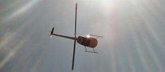 Mike took this shot as I flew by.
 My tours out of the Phoenix area — including Scottsdale, Deer Valley, and Glendale — start at $795 for up to three people. That’s not per person; it’s per flight. (It costs the same for me to fly no matter how many I have on board, so why screw around with complex per-person pricing and minimum passenger numbers?) That price will get you a great 50-60 minute tour of the entire Phoenix area, including a flight right down Central Avenue at building rooftop level.
 But since I’m based in Wickenburg and I don’t have to fly anywhere to do a tour from Wickenburg, my prices out of Wickenburg are considerably lower. For example, I can do a 25-minute tour of the area for only $195 for up to three people. (Sign up soon; the price is jumping to $225 when the 2007/2008 season starts in October.) I offer short tours like that in Wickenburg in an effort to provide a service that locals can afford. But apparently the folks who find my brochures down in Phoenix — and there seem to be an awful lot of them — are willing to trek up here in their rental cars to take the shorter tour.
 Instead, if they’re anywhere near I-17 or Loop 101, I send them to I-17 north and tell them to get off on Carefree Highway (Route 74). Head west for about 35 miles on a traffic light free, two-lane road that goes past Lake Pleasant and through some beautiful and still pristine Sonoran desert landscape. Lake Pleasant’s overlook makes a nice stop on the way or on the way back, I tell them. At the end of Route 74, make a right on Grand Avenue and drive 10 more miles to Wickenburg. Go through three traffic lights. About 2 miles past the third traffic light is the airport, on the right. I’ll be waiting by the red helicopter, I add.
 We go for a flight around the area and I point out the three main guest ranches (which are closed for the summer), Vulture Mine (which is closed for the summer), Downtown Wickenburg, the Hassayampa River Preserve (which has limited hours in the summer), the river (which may or may not be flowing; usually not), and Box Canyon. If it’s a weekend, they’re usually thrilled to see people driving quads and trucks down in the narrow slot canyon where the water always flows. They’re always impressed by some of the larger homes on the south and northeast sides of town, especially the one with the heliport and the big yellow house that looks so unusual here. We sometimes see cows from the air, but seldom see anyone on horseback. It’s just too darn hot in the summer.
 Monument Valley is on the Navajo Reservation, which is the largest of all Native American Reservations in the country. Access to the rock formations we know as monuments is controlled through the entrance of the Navajo Tribal Park. There are reasonable fees for entering and driving your own vehicle into the park. But for an additional fee, you can go with a Navajo Guide who will take you places you’re not allowed to go on your own. If you have the time, I recommend this, as it’s likely to be your only opportunity to step inside a traditional Navajo hogan.
 I normally fly to the park from Page along the southeastern side of Lake Powell. There’s a landing strip at
  Of course, to learn whether the tour would be good, I had to take one. I’ve actually taken the tour three times. I took this photo on the most recent trip. It shows two of the most famous monuments: the Mittens. They got the name because they look like those woolly things you might have worn in the winter as a kid. They’re formally called East Mitten Butte and West Mitten Butte. They stand hundreds of feet off the desert floor, towers of red sandstone that are still eroding in the high winds and summer storms of northern Arizona.
 A while later, we were down in a canyon beside a spring-fed creek. Flies were biting. We checked out the condition of the larger cabin, then examined the raspberry bushes. We were at least two weeks too late.
 We heard an approaching helicopter, then saw Ray circling above the trees. We walked out where he could see us. Although he normally lands in a clearing on the other side of the creek, he found a spot near us. We were back by the helicopters when he shut down. I snapped this photo with my Treo for my