The Fruits of My Labor…

…or why I love my work as an aerial photography pilot.

Regular readers know that one of my jobs is as a helicopter pilot. Sure, my little company offers tours and day trips from Phoenix in the winter and dries cherries in Washington State in the summer, but my favorite kind of flying is for aerial photography.

To me, there’s nothing more rewarding than being a pilot for a talented still or video aerial photographer. These are the people who not only understand basic photographic concepts such as light and composition and exposure, but who also know what a helicopter can do and how they can use it as a tool to get amazing images of the world around us.

In August 2010, I had the privilege of working again with Mike Reyfman, a regular client, over Lake Powell in northern Arizona/southern Utah. He was there for the AirPano Project, capturing images that would become interactive 360° aerial panoramas, as well as still photos around the lake.

He emailed me yesterday to let me know that the Lake Powell Panoramas had finally been put online. There are four of them, including one shot over Reflection Canyon (see screen grab below). Each image is interactive, drag in the image to pan and zoom. You can click on the helicopter icons to switch from one viewpoint to the next. Here’s where you can find them.

Reflection Canyon

Aerial photo work is challenging, especially with a demanding photographer on board who knows exactly what he wants. Mike is one of those photographers. Not only does he know what time of day he wants to shoot, but he provides instructions regarding shooting location, direction, and altitude. For the panoramic shots, I need to get into an out of ground effect hover, sometimes as high as 3,000 feet above the ground, and hold it there for 5 minutes or more. This isn’t easy in my little R44, especially in windy conditions.

But it’s worth it, as Mike’s panoramic images and other shots prove.

I find it especially rewarding work, though. Although I didn’t create the incredible images the photographers on board make, I feel that I was instrumental in making those images possible. After all, my helicopter and I were part of the photographer’s equipment — almost like a tripod. Surely to say that the image would not exist without us isn’t too far from the truth.

And so despite the challenges and the relative dangers, I love flying aerial photographers. And I love seeing the work they create when they fly with me.

More GoPro Camera Tests, More Aerial Photos and Videos

Another chapter in my never ending saga: any excuse to fly.

Early this week, it rained.

That might not seem like a big deal to most folks, but it rains very seldom in Arizona. In fact, I hadn’t experienced a good rainstorm since my drive back from Washington state in October.

This week, it was cold and rainy for two days in a row. With rain comes three things:

  • Clouds, which make our normally plain blue sky more interesting and give it depth.
  • Cleansing, by which I mean that the dust is washed off the desert rocks and plants, making their colors more vibrant.
  • New growth in the desert, which makes everything look just a tiny bit greener than it otherwise would.

You need to be a desert dweller to really appreciate these things.

There’s nothing I like more than to go flying over the desert right after a good rainstorm. So on Wednesday, as the storm clouds moved north and blue sky started to appear again, I loaded up my GoPro cameras and mounts, hopped in the car, and drove up to Deer Valley Airport, where my helicopter is living part-time this season. When I arrived just before 9 AM, my helicopter was sitting out on the pavement, ready for me to preflight, set up my cameras, and go.

The Camera Setup

I took my time about setting up the three GoPros. I have three different models and I use each one for a different purpose.

  • GoPro HD Hero2 Professional – With its sound-in port and better lens and recording capabilities, I normally mount it on the helicopter’s nose as the “nosecam” and connect it to an audio-out port I had put into the helicopter a few years back. It captures not only intercom communications, but all radio communications. Basically, anything I hear in my headset is also sent out through that port to my GoPro. Here’s an example of an image from the video on this camera, shot at 720p:
    Bartlett Dam Nosecam
  • GoPro Hero HD Original – I mount this between the helicopter’s two back seats, inverted, to capture a wide-angle view of what’s going on inside the helicopter and beyond. This “cockpitcam” view works fine with passengers, but it doesn’t give a close-up view of the instrument panel. For that, I need to mount the camera forward, on the bar between the two front seats. Here’s a view from the camera as I had it mounted Wednesday, also shot at 720p video:
    Back Seat View
  • GoPro Hero 960 – Because I haven’t been exactly thrilled with the 1080p video coming out of my original GoPro HD Hero, when I decided to invest in a second one, I went with the cheaper model, which can’t shoot 1080p video. Instead, it shoots up to 1280×960. I like the widescreen format, so I shoot 1280×720. I saved about $100. On Wednesday, I used a new skid mount and set it up to snap a 2592 × 1944 still image every 10 seconds. (In the 20-20 vision of hindsight, I should have set it up for every 2 seconds; 6 shots per minute isn’t quite enough when you’re cruising at 100 miles per hour.) Here’s a sample image from that “skidcam”:
    Bartlett Dam

So to summarize: I set up the helicopter as a camera mount for three different cameras: 2 shooting video and 1 shooting stills.

The Flight and Some Photos

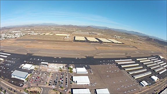
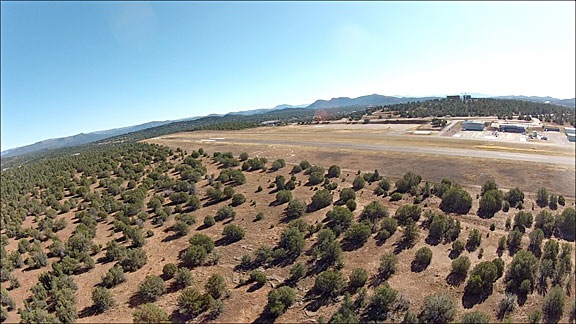
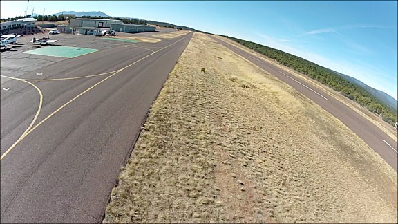
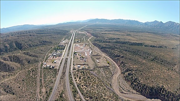
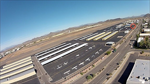
I turned on all the cameras, climbed into the cockpit, and started up. Five minutes later, I was overflying Deer Valley Airport at 500 feet AGL, northbound. Here’s a nice shot of the airport from the nosecam:

Deer Valley Airport, Northbound

The beauty of all this was that with this setup, I’m able to capture images from three cameras without having to even think about any of them. Absolutely no distraction for me, allowing me to keep my full attention on my primary duties as a pilot: aviate, navigate, and communicate.

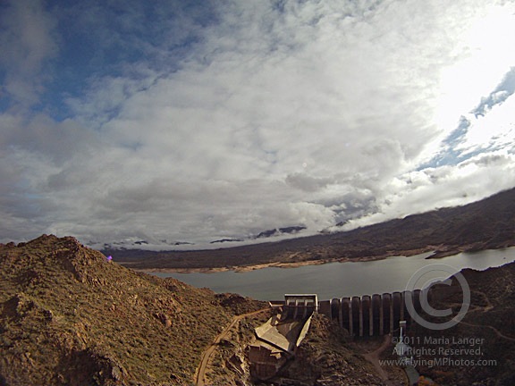
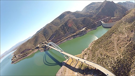
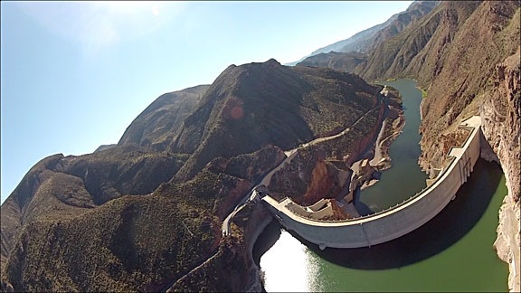
The flight was not quite what I had in mind. I was hoping to overfly Lake Pleasant and get all the way to Wickenburg. But as I neared Lake Pleasant, I saw low clouds over the lake. There was mountain obscuration to the northwest — which means the clouds were pretty darn low, since those mountains aren’t exactly lofty peaks. Here’s a nose cam image of the marina at Lake Pleasant near the dam; you can see the low clouds at the north end of the lake:

Marina at Lake Pleasant

I wasn’t very interested in getting images and video shot in overcast conditions. So I decided to head east, where the sky was clearer and sunlight was filtering through to the desert floor.

There was a balloon flying southeast of Lake Pleasant and I tried to get some shots of it with the skidcam. Trouble is, the GoPro’s very wide angle lens exaggerates the distances. If I wanted a good shot of the balloon where it looked close, I’d have to get much closer to the balloon. While I think I could have gotten closer safely, I didn’t want to give the balloon operator or his passengers heart failure so I stayed clear. This is the best I could get; again, a shot every 2 seconds would have given me more to choose from.

Hot Air Balloon

As I flew east, the two front-facing cameras were pointing toward but not exactly into the sun. GoPro cameras get their best images when the sun is at an angle of at least 60 degrees from the lens. According to the LightTrac app on my iPhone, at about 9:45 AM the sun was at about 140 degrees. I was flying at about 90°, so the sun was at 50° angle to the front-facing cameras. At the same time, it was at a 40° angle to the skidcam, which was facing almost due south. (Obviously, I didn’t look up the angles while flying.) As a result, the images from this leg of my flight were pretty disappointing. Here’s an example from the cockpitcam as I flew over the intersection of I-17 and Carefree Highway:

I-17 and Carefree Highway

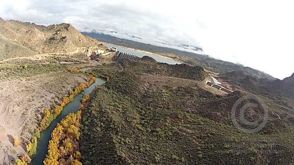
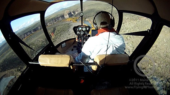
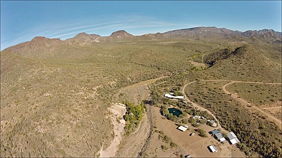
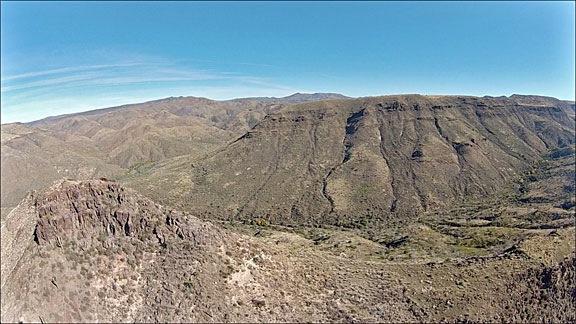
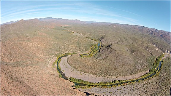
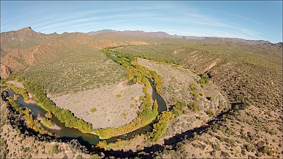
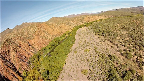
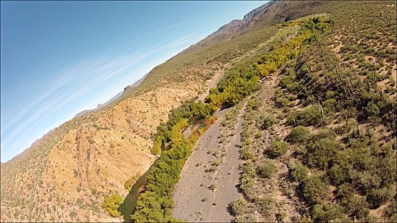
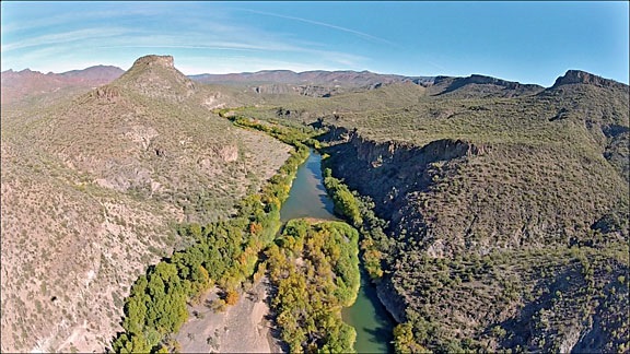
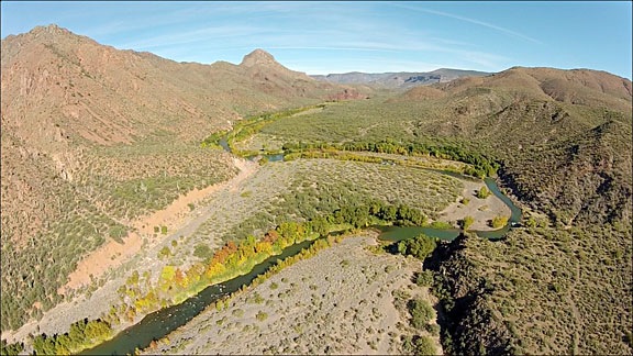
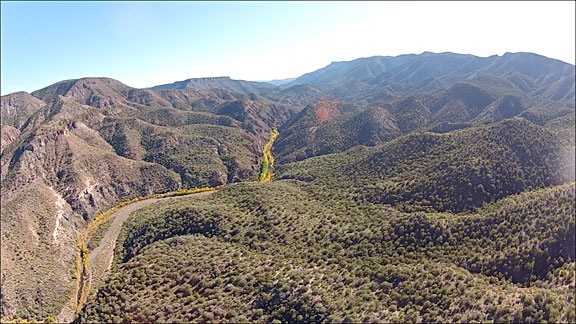
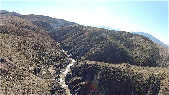
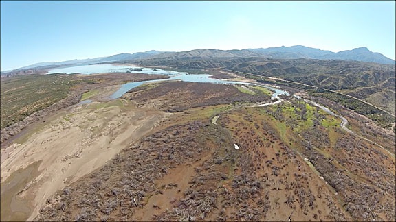
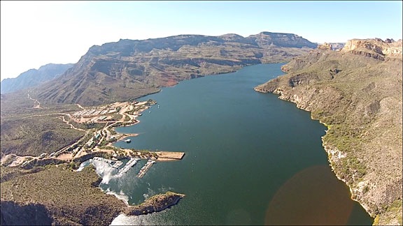
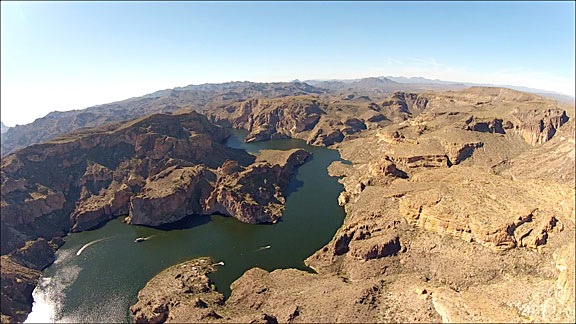
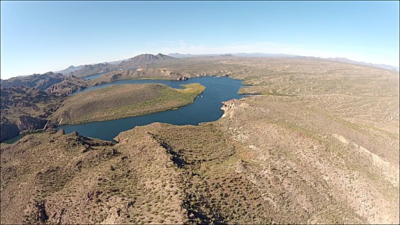
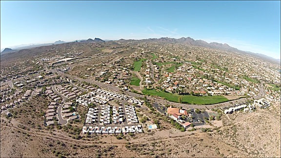
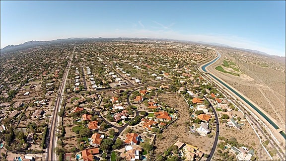
I flew all the way out to the Verde River and then headed up the river as far as Bartlett Dam. The two photos near the beginning of this post shot nosecam and skidcam views. Since more gray skies and low clouds covered Bartlett Lake, I turned around and headed south. The cockpitcam shot near the beginning of this post shows my view as I headed approximately southwest. After a tiny bit of shallow canyon flying (see nosecam photo below), I headed toward Scottsdale where sun, low clouds, and rocky outcroppings made for interesting views.

Canyon Near Verde River

I got a nice shot of Pinnacle Peak from the skidcam at several altitudes for use in a book project I’m working on.

Pinacle Peak

I also got nosecam and cockpitcam footage as I approached the peak. Interesting to see the difference between these two views, shot at about the same time.

Approaching Pinnacle Peak

Approaching Pinnacle Peak

By that point, I’d been in the air for about an hour and thought I had enough footage to test my setup thoroughly. I headed back to Deer Valley. The one mistake I made was that I flew along side a power line, with the power line on my right — right in the view for my skidcam. This was very unfortunate because the camera was facing north at this point and could have captured a lot of nice footage. Instead, all the footage features the damn wires.

Wires in my Photos

I guess that proves that I wasn’t really thinking much about the cameras.

And for those who are interested in such things, this is the track log of where I flew, as recorded on my iPad.

Track Log

The End Result

In all, I got just over 300 photographs and 2 hours of video — an hour from each camera. Quite a bit of it is useable and will likely appear in edited video content I produce in the future.

I plan to try shooting video from the skidcam. I could see it from my window and checked it a few times in flight to see how much it was vibrating — it didn’t seem to be vibrating much at all. Of course, you can never tell until you shoot the video and see the results. So that’ll be my next test, probably tomorrow.

A Final Note about the Camera Setup

I took photos of all my cameras as they were mounted before beginning the flight. I hesitate, however, to share them or provide detailed information. Although I know many pilots who regularly mount cameras on the outside of their aircraft, it’s one thing to talk about it and another to document it with photos for the world to see. I’m very confident in two things:

  • Any camera I mount on the outside of my aircraft will not fall off. I use several safeguarding measures to ensure this. I am positive I will not lose a camera.
  • None of the mounting locations affects the aerodynamics of my aircraft. In other words, it flies just as well with the cameras attached as it does without them.

These are the only things that should concern a pilot or anyone overseeing that pilot’s activities.

Comments? Questions?

I welcome your comments, questions, and suggestions. Post them here.

A Few Aerial Views from Today’s Flight

Any excuse to fly.

Don and I went flying today. Don had left his jacket at the Payson Airport (PAN) restaurant. I had just gotten a pair of Bose A20 headsets I wanted to try. Seemed to make sense to fly up to Payson, retrieve Don’s jacket, and give the headsets a try.

We left Deer Valley Airport (DVT) at about 10:30 AM. As usual, I had a GoPro hooked up on the helicopter’s nose, recording 720p video. The photos throughout this blog post are frames from the resulting 2 hours of video. I figure I’ll let the photos and captions tell the story.

Northbound over DVT
My usual view of DVT as I depart to the north. Helicopters are instructed to cross the runway midfield at 500 feet AGL. Planes take off and land beneath us; the traffic pattern is above us. (You can see a complete departure on video here.)

Johnny Carson's House?
Don was told that this little ranch once belonged to Johnny Carson. Who knows? All I know is that it’s in dire need of a new roof right now.

Indian Ruins
Although nearly impossible to spot in this photo, this ridge was completely covered with the ruins of an ancient indian pueblo. I can think of nearly a dozen such sites — all inaccessible by road or trail — in Arizona.

Desert Valley View
On first reviewing the video, I thought this was the Verde River Valley. It’s not. The Verde River is over the next mountain range. Whatever.

Verde River
We joined the Verde River just north of Horseshoe Lake, which is pretty much empty right now.

Verde River
The river twists and turns through a canyon that’s wide in some places and narrow in others.

Verde River
Sometimes I follow the river quite closely.

Verde River
It’s great to fly with another pilot who doesn’t freak out when you bank a little sharply. What do you think? Not quite 45°, huh?

Verde River
The trees along the river — and in any narrow canyon where cottonwoods can grow — are all beginning to change color.

Verde River
Who says Arizona doesn’t have seasons?

East Verde River
At the Confluence of the East Verde River, we turned right and followed that toward Payson. The wind kicked up here and we got bounced around a little, but nothing bad enough to spoil the flight.

Payson Airport
Eventually, we arrived at Payson Airport. I crossed the runway midfield low-level and set down on the ramp.

At the airport, Don and I went into the restaurant and had a late breakfast. There were boxing up pies for sale — tomorrow is Thanksgiving after all — and I bought two of them. Don and I dug into one right at the restaurant, since Mike doesn’t like strawberry rhubarb and Don and I both do.

Departing Payson
We took off along the taxiway (sort of) and headed south along the main road toward Roosevelt Lake.

Rye, AZ
Along the way, we passed over the town of Rye, shown here in its entirety from about 500 feet up.

Tonto Creek
We hooked up with Tonto Creek and followed it down along a canyon neither of us knew existed. There’s nothing I like better than discovering new places when I’m out flying. This might have been the first time I’d flown between Payson and Phoenix.

Roosevelt Lake
Eventually, we reached the north end of Roosevelt Lake on the Salt River. The water level was down, but not nearly as much as Horseshoe Lake.

Roosevelt Lake Bridge
The lake is created by a dam on the Salt River. There’s a really nice looking bridge near it. I had to get kind of close to get this shot. Funny how the water looks green from certain angles.

Dam at Roosevelt Lake
We rounded the bend at the dam and headed down the Salt River Canyon toward Phoenix.

Apache Lake
Next up was Apache Lake, shown here near the motel/marina complex, which is quite a way down the Apache Trail’s unpaved road. As we neared the canyons on the downstream side of the lake, the wind started bouncing us around pretty good.

Apache Lake Dam
This dam creates Apache Lake. Two items of interest here: the helipad on the lake side of the dam itself — really! — and the network of wires running down the canyon. I would not like to land at that helipad. (Well, actually, I would, but that’s because I’m curious to see if I could do it gracefully.)

Canyon Lake
Canyon Lake is one of my favorites. A bit more accessible by car than Apache, the lake winds through canyons after this point. Next year, when I bring my little boat back from Washington State, I’ll take it out on this lake for a weekend with my camping gear. Lots of places to camp along the lake.

Saguaro Lake
We flew past the big “S” of Saguaro Lake from the uptake side. Saguaro is the most accessible of the Salt River Lakes so it’s usually the busiest on weekends. We flew over on a Wednesday, so it was pretty quiet.

Fountain Hills
After flying along the Salt River for a while and seeing a handful of wild horses standing in shallow water there (sorry, no good photos), we headed west, over Fountain Hills.

Scottsdale
Then we crossed over the southmost end of the McDowell Mountains and descending into the Scottsdale area. We headed toward Scottsdale Airport (SDL) and crossed over the top at 500 feet AGL, right behind a Cessna doing touch and goes. Then I adjusted course to Deer Valley Airport.

Landing at Deer Valley
I landed at Deer Valley from the west, as I usually do, making a sharp right turn over Deer Valley Road. The red circle in this photo is my landing zone at Atlantic Aviation there. It’s a tricky LZ, mostly because it’s such a tight confined space and there’s a few light poles to avoid on the way in.

Don left while I took my time getting my things together. It had been a nice day out.

Any excuse to fly works for me.

A Trip around the Peninsula, Day 1: Wenatchee to Port Angeles

We take a road trip around the Olympic Peninsula in Washington state.

After three months contractually bound to the Quincy and Wenatchee areas of Washington, I was finally off contract at the end of August. Mike flew out to Washington and we went on a road trip to the Olympic Peninsula. This series of blog posts is a summary of that trip, with photos.

The start of our five-day vacation.

After fueling our diesel pickup — the only vehicle available to us here — we headed out of Wenatchee on Route 2 toward Stevens Pass. We made a number of stops along the way.

First, Anjou Bakery in Monitor, which makes an outrageously good pear danish. It’s in a funky old building with indoor and outdoor seating. They make coffee drinks, too, but I’ve decided to avoid that on my next trip. Their coffee isn’t very good — at least in my opinion — and it takes far too long for them to prepare it.

Next, Leavenworth. If you’ve ever been to Leavenworth, you’ll know that it’s a manufactured tourist town. They redid the entire town with a Bavarian theme, making it feel almost as if you’re in a Black Forest village somewhere in Germany. (I’ve actually been to Germany’s Black Forest, so I can attest to this.)

For the record, I don’t like Leavenworth. It’s a fake place that exists primarily for tourism. The parking and traffic situation is horrendous. Its multiple shops and restaurants are designed to suck tourists in and relieve them of their money. Little of what they offer is any better than you’d find at any other similarly themed tourist shop or town. I know that all tourist towns are like this and I don’t like any of them. Frankly, I don’t know why so many people go there.

But Leavenworth does have two shops that I love:

  • The Cheesemonger is possibly the best cheese shop I’ve ever been to. Not only do they have an amazing selection of cheeses from around the world, but they are well-staffed with knowledgable and helpful counter people. Cheese tasting is not only allowed but encouraged. This shop is my primary reason for subjecting myself to a trip to Leavenworth.
  • Cured is a smoked meat shop where you can get excellent bacon, sausage, wursts, jerkies, and more. Their buckboard bacon is to die for. If I make a cheese run, I also stop here for meats. Bonus: there’s motorcycle parking right across the street.

On this visit, we also stopped at the Bavarian Bakery on the right as you come into town from Wenatchee. It was recommended by the folks at Cured for bread; they hadn’t received their delivery yet and I like their rolls with the cheese. My grandfather was German and owned a bakery in Cresskill, NJ when I was a kid. For a while, my family lived in an apartment upstairs. So visiting a real German bakery was a treat for me. We bought some plum cake (which my Grandfather also made), pretzels, a coffee cake, and the rolls. I wasn’t terribly impressed with any of it, but it wasn’t bad. I’m just picky.

We loaded up the cooler that we’d brought along and headed out of town on Chumstick Road. That would take us winding through the mountains, though the tiny town of Plain before reaching Lake Wenatchee. At Route 207, we headed northwest, following 207, then Little Wenatchee Road, then National Forest Development Road 65. I’d ridden this route on my motorcycle the week before but had turned back after 10 miles or so because I wasn’t sure whether it was paved the entire distance.

We took a side trip, following a sign that promised a View Point 4 miles up an unpaved road. The road wound up and around through dense forest, finally depositing us at the promised viewpoint. We could see Lake Wenatchee in the light haze.

Another couple was there — a bit older than us and seriously out of shape. They were wrestling with something heavy in a blanket, trying to get it into the back of their pickup. We didn’t snoop until they were gone. Then we followed the short trail they’d come from and discovered a place where people had been cutting stone from the side of the hill. Cutting, like with a stone-cutting saw. The kind of equipment that requires a generator and probably water to cool the blade. I don’t think they had that equipment; they might have been taking a loose rock. It looked like granite to me, but it could have been something else. (What do I know about rocks?) The whole thing was weird; it had taken us 20 minutes to drive the 4 miles; why would anyone lug stone-cutting equipment up there?

We continued along the Forest Road and, sure enough, not far from where I’d turned around on my motorcycle, the pavement ended. We followed the road through the forest, enjoying the views along the way. At one point, a Jeep caught up to us and we pulled aside so it could pass. Otherwise, there wasn’t much in the way of traffic.

Old Growth TreeI should mention that much of this was old growth forest. An absolutely huge tree grew close to the road and we got out to take a closer look. Its amazing to me that trees this large exist and that so many of them have been cut down. Actually seeing one is a real treat.

The road we were on ended at Route 2 and we continued through Stevens Pass and down to the west side of the Cascades. That’s when the traffic started up. It was Labor Day afternoon and everyone who had journeyed east for the weekend was heading home. I whipped out my iPad and the Maps app and found some alternate routes that paralleled Route 2. We probably saved about 30 minutes of drive time by taking these longer routes, each of which dumped us back on Route 2 after a pleasant drive through farmland or forest. Then we abandoned Route 2 completely in favor of Routes 522 and 524.

We stopped at Snoqualmie Ice Cream shop in Malby. The ice cream was good, but, in my opinion, not worth the very high price we paid for it. And the girl at the counter who served it had the personality of a wet rag.

Sailboat on Puget Sound with Mount Baker in BackgroundBack on the road, we continued along Route 524 to Edmonds and got on line for the ferry to Kingston. We’d timed it well and didn’t have to wait more than 15 minutes to get on the boat. We went up on deck to check out the view. Mount Baker was clearly visible to the northeast and even Mount Rainier could be seen through the haze to the south. I passed the time photographing sailboats we passed, trying to get Mount Baker in the background.

In Kingston, we didn’t hang around. It was getting late and we were hungry and unsure of where we’d be spending the night. We’d already planned on spending Day 2 in Victoria, BC, so we wanted an overnight stay someplace close to Port Angeles, where we’d pick up the ferry. So we headed that way on Route 104 and then 101.

We detoured to Dungeness. I don’t know what we expected to find there, but we didn’t find any interesting lodging opportunities. We did, however, find the Three Crabs Restaurant right on the bay. If I had to rate this place on service or atmosphere, I’d pan it. It had all the charm of a cheap family restaurant catering to people with low expectations. But the food — well that was a pleasant surprise. I had the best fried oysters ever — and I don’t toss around the word “best” very often at all. That made it worth the visit. (And here’s a tip to restaurant-goers who rate restaurants on Google, Yelp, etc.: don’t order steak in a seafood place.)

We got back on the road and headed toward Port Angeles. By this time, it was getting dark. My maps app suggested the Olympic Lodge and we homed in on it. It was a bit bigger and fancier than we expected. But it was evidently also empty. We went to the desk and they offered us a discounted rate within our price range. We took it. The room was large and comfortable. A fountain at ground level outside our window offered a nice soundtrack to a good night’s sleep.

Our Route:

With Photography, It Pays to Experiment

You never really know what shot is going to turn out to be your favorite.

I went on a hike yesterday morning with a friend. We met at 6:30 AM and proceeded to hike up a steep trail on the west side of Wenatchee, WA. It was a mostly clear day with thin clouds overhead and smoke from a fire about 30 miles away drifting in over the city.

Lone PineI brought along my camera. I didn’t really expect to find anything of interest to photograph, but on nearing the top of the first big hill — after an elevation gain of about 800 feet in 1-1/2 miles — I caught sight of a lone pine tree on a hilltop off in the distance. It reminded me a bit of the Lone Cypress at Pebble Beach. (Just a bit, mind you.) I had a subject for a shoot and captured multiple images of it against the sky. I thought that with the sun behind it, I’d get a nice silhouette. I peeked at the screen in the back of my camera after each shot and liked what I saw. (More on that in a moment.)

Weeds with TreeAs I continued the hike — my friend had gone up ahead because I’m so damn slow when hiking uphill — I got a little artsy with some weeds along the trail. I liked the way the sun shined through them. Remember, the sun was up ahead of me. Again, from what I could tell, the image looked interesting in the screen at the back of the camera. I felt good — as if I were getting some interesting shots.

I met up with my friend and we stopped near the base of the pine to take in the view. I only had one lens with me — my 16-85mm — so I couldn’t get a shot of the tree as close as I would have liked. But I figured I’d already gotten some good shots, so I didn’t beat myself up over it.

But as we were turning away, I decided to experiment anyway. The city was spread out beneath us, under a layer of haze from that forest fire. The light on the mountains in the distance was still warm. The clouds were interesting and random. So I shot one more photo before we began the hike down. I peeked at it on the LCD screen and wasn’t impressed.

That evening, I looked at the photos I shot on my 27″ iMac’s monitor. I was disappointed — to say the least — in the “lone pine” shot I thought would be good. Apparently, my eyesight simply isn’t good enough to see detail in the little screen at the back of my camera. Even the shots with the weeds didn’t do anything for me.

But the last shot — the one with the city in the background — the one I just framed up and snapped almost as an afterthought — that turned out to be my favorite shot from the morning’s hike. What do you think?

Lone Pine Over Wenatchee

I take away two things from this experience:

  • My eyes suck. I really can’t depend on what I see in that tiny LCD screen to know whether an image I captured is any good. I should probably bring along cheaters so I can actually see what’s in the damn screen.
  • Experimentation can be a very good thing. If I hadn’t tried that one last shot, I wouldn’t have come away with any images that I liked. I should definitely experiment more so I have more to look at back at my desk.

Thoughts?