A few facts, from a long-time resident.
We’ve lived in Wickenburg for about eight years now. Sadly, neither of us like the way things are going in town.
When we came to Wickenburg, it had small town charm and lots of open spaces. Since then, the developers (and their good buddies or relatives, the Realtors) have taken over. They’ve reshaped the desert so there are flat spots where there were once hills and they’ve planted houses on them. They’re kind of tricky the way they do this. They cut the land into lots, then build on every other lot. Folks buy the houses because they see so much space between them. Then the developer fills in the gaps and gets other people who like close living to buy those homes.
We have 2-1/2 acres in a very hilly area, with a wash flowing right through our property. That’s good because it keeps our neighbors far away — which we like. It’s not that we don’t like people. It’s just that we don’t like the idea of people looking into our windows from theirs. Now they’re all far enough away that we really don’t need to close the curtains for privacy. I like that. I like lying in bed at night and looking out at the stars.
But the rest of the town is being sold off at an alarming rate. One developer, who I took for a helicopter ride so he could get aerial photos, commented to his friends on how he was hoping to buy the land a church and pastor’s house is on so they could bulldoze it down and build some more condos. I was shocked. The church can’t be older than five years. And where will the parishioners go? I’m not a religious person, but I do have feelings for churchgoing people. Sadly, the developers don’t.
It wouldn’t be so bad if the town’s infrastructure would grow with the development. But it doesn’t. The downtown area is dying, slowly but surely, with much of its space taken up with private “Not a Retail Outlet” offices and vacant storefronts. Every strip mall has at least one empty space, if not more. One block downtown had about 50% of its space empty. I spoke to a property manager about renting one of the storefronts with the idea of setting up a cooperative art gallery, a place for local artists to sell their work. I told her I was concerned about having so many empty storefronts nearby — the area would never attract browsers. She assured me that she was talking to others about renting the other empty storefronts. When I asked her what kind of businesses might be going in, she told me a title company would be moving next door. A title company? There was already a mortgage company in that block. And more offices across the street. Why would I want the only retail business on the whole block? I decided to save my efforts — and my money — for a town with more potential.
Wickenburg’s job situation is equally dismal. There are a few good paying jobs with Remuda Ranch, the Meadows, and the Town of Wickenburg. But most of the town’s other businesses offer low-paying, minimum wage (or slightly higher) part time jobs with few or no benefits. The good jobs aren’t easy to get, either. A friend of mine interviewed for a wrangler position at Remuda Ranch a few years ago. She came away from the interview with a bad taste in her mouth. “I wasn’t Christian enough,” she told me. I guess 20 years of experience wasn’t enough for them if the applicant couldn’t meet the unspoken (and unadvertised) religious requirement.
The new business survival rate in Wickenburg is pitifully low. I think that problem is threefold:
(1) Many businesses are undercapitalized when they begin, so they’re doomed to failure. Common business sense says you need enough capital to pay for business expenses for a whole year before you start your business. Too many people depend on revenue that just doesn’t cut it. That’s why that Property Manager’s client prefers to rent to offices; they’re not depending on retail revenue for survival.
(2) Some businesses offer goods and services that there just isn’t a demand for in Wickenburg. The skateboard shop on Valentine Street is a good example. It was a great shop with lots of good merchandise professionally displayed. But let’s face it: Retirees don’t skateboard. And there weren’t enough skateboarders in town to support the business. Another example was the clothing shop that opened in the relatively new strip mall on the east side of the bridge. I never got a chance to get in there — they were open for less than a year — but I was told that their merchandise was expensive. That just won’t fly in a town where the fixed income retirees and minimum wage workers would prefer to shop in Alco or Wal-Mart.
(3) The town and Chamber of Commerce has no clue (or desire) to help local businesses survive. The town seems more interested in increasing town revenues through property taxes than sales taxes raised by thriving businesses. The town fathers have no qualms about allowing chain restaurants to open next door to existing locally-owned and operated restaurants selling the same type of food. (How many pizza places does Wickenburg need, anyway?) Lately, the only new businesses to come to Wickenburg and last more than a few months are the two “dollar stores” and two check cashing/payday advance places. These are the kinds of businesses that appeal to the lowest income tier or, worse yet, the fringe element responsible for the town’s drug problems and crime. The few events sponsored by the local Chamber of Commerce benefit only a handful of businesses — the motels and restaurants on their favorites lists. Many of these events are poorly publicized and have disappointing attendance anyway. Worse yet, they’re the same old events, year after year, without any new twists. Ho hum.
So people might ask who’s buying all these houses if the town has these economic problems. I ask it all the time. But the answer is clear: retirees.
Wickenburg regularly makes a list of top places to retire. So the folks from the midwest flock to Wickenburg and buy homes. Some of them live there only half the year, which, in turn, further deteriorates the town’s economy by making it impossible for some businesses to survive in the summer. Others live here year-round, but do most of their shopping down in Surprise, at Wal-Mart. That’s also where they fill their cars with gas and visit their doctors. Every once in a while, they clamor that they want a Wal-Mart in Wickenburg. I guess it really doesn’t matter to them if Wickenburg’s remaining small town charm is destroyed by a big box store, as long as it makes cheap shopping more convenient for them. After all, it might increase the choices of minimum wage jobs: clerk in housewares, clerk in electronics, clerk in ladies clothing, etc. It certainly won’t increase the number of employers — if a Wal-Mart comes to Wickenburg, just about every other retail business will be forced out of business.
I wish I didn’t have to report these sad truths about Wickenburg. I wish I could lie or paint a rosy picture of town, the way the Chamber of Commerce and newspaper do. But I’m not a liar. And my rose-colored glasses just don’t tint the picture enough to report it any other way.

 Elizabeth arrived at 7 AM and I was ready to go. We started off with a little tour of Howard Mesa. Elizabeth used my camera to take a photo of her house (see photo). I pointed out all the little cabins and sheds and trailers that you can’t see from the road. Then we went up to Valle and followed 180 east. She showed me where some friends of hers had just bought some land and I showed her Red Mountain. From there, we headed north. It had rained the day before and I was interested in seeing if there was water in the Little Colorado River. There wasn’t. I took her to the Little Colorado Gorge lookout, just outside the Grand Canyon SUA, and was disappointed to see the canyon bottom just as dry as it had been the last time I flew over.
 As we flew along the cliffs near The Gap, she admitted that she’d never been to Page. I told her a little about it. I figured we’d land at the airport, then take the free shuttle to the marina where there was a restaurant. But when I pointed out the Vermillion Cliffs in the distance ahead of us, I got a better idea. Marble Canyon. The runway is right across the street from the lodge and restaurant. Elizabeth was game. Actually, I don’t think she cared where we went. I didn’t really care either, for that matter. Elizabeth took a few photos of the landscape we flew over, including this shot in the Cedar Ridge area. She was fascinated by the geology of the land, especially the tilted layers of multi-colored rock. I explained how some of the more obvious formations were made and told her I had a book about Grand Canyon geology that probably explained a lot more. We were flying over the Navajo Reservation and, when we were away from the main road, we saw lots of ruins of old hogans and animal pens. That’s the kind of stuff that interests me. I especially liked the animal pens that had been built into natural rock formations — like a box canyon with its open side fenced off or animal pens built entirely of stone.
 We crossed the Colorado River at Marble Canyon and landed at Marble Canyon’s airstrip. I set down on the dirt ramp area and shut down. It was about 8 AM and the morning sun was still low enough to make the Vermillion Cliffs behind us…well, vermillion. In my opinion this is the most scenic spot anyone can use as a backdrop for a photo of their aircraft. In fact, it’s enough of an excuse to fly in to Marble Canyon. Just be advised: the runway is very narrow.
 We had breakfast at the lodge restaurant. It wasn’t anything special. I think our waitress may have been more interested in listening to her MP3 player than serving us. Afterwards, we climbed back on board and took off to the north. A plane had just taken off from Marble Canyon’s runway, so I had to stay a bit low until it passed over us. (I didn’t use the runway.) Our flight path gave us great views of Navajo Bridge and the river at Lees Ferry, as well as Horseshoe Bend further upstream. Elizabeth kept snapping photos, like this one, which kind of gives you an idea of the visibility in a helicopter. Don’t mind the reflections in the bubble; I was wearing my loud white pants again. And yes, that’s my hand on the cyclic.
 Tyler was very surprised when I climbed on board beside him. He fiddled with the intercom switches so I could hear the radios, which I really appreciated. It really helped bring back memories of all the flights I’d done. I discovered that I was booked on the shorter North Canyon flight, which goes over to the Dragon Corridor on the west side of the canyon. But since there was a lot of smoke on that side of the canyon due to a controlled burn, we’d be doing an East Canyon tour. Although Papillon doesn’t sell that tour, it is the best one. It starts off like an Imperial Tour, going out over the east side of the canyon, then turns west at the confluence of the Little Colorado River and makes a big loop back to the rim.
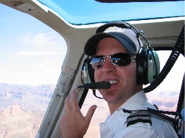 The canyon was hazy but beautiful. I had my camera with me and took a few pictures, including this one of Tyler in flight. (I always wished I’d asked one of my passengers to shoot a picture of me like this, at the controls with the canyon in the background. I’ll e-mail this to Tyler.) When we got back, I kept Tyler company while he shut down. Then I went inside to see if John was finished with his meeting. He wasn’t. I thanked Evelyn and Ilse for the flight and chatted a while with Ilse. Then, as it was getting late, I wrote a note for John on the back of a Flying M Air postcard and left it on his desk. It asked him to give me a call when he had time for a ride in my helicopter.