A look back at a memorable flight.
Since the winter/spring of 2013, my helicopter has spent two months each year in the Sacramento area of California on a frost control contract. I fly the helicopter down in late February and fly back in late April. I usually take along a fellow pilot who does most of the flying to build R44 time and shares the cost of the flight. Most of these people are relative strangers and although they’re usually nice guys or gals that I stay friends with after the flight, I admit that I prefer flying with people I already know pretty well. So this spring, when it came time to start thinking about that return flight, I started thinking about who I could invite to join me.
The answer hit me like a lightning bolt: of course I should invite my friend Don.
Don’s been a pilot for much of his life and has flown airplanes and helicopters. I don’t know how much time he’s logged, but I’m certain it’s more than my 3,300 hours. I also know he has tons of cross-country experience, including helicopter flights between the Seattle area and Alaska.
Why Don?
You might be wondering why I’d invite such an experienced pilot when there were so many low-time pilots who’d likely jump at the chance to fly with me on a six to eight hour cross-country flight. There are three reasons.
First, Don is a good friend I’ve known for years. He and his wife were very supportive during my crazy divorce, and you know what they say about a friend in need. He’s easy going and has a good sense of humor. I knew I’d enjoy spending time with him.
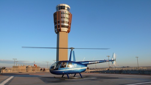
Don’s helicopter on the T3 Helistop at Sky Harbor Airport in Phoenix in 2009. After I shared my experience approaching and landing at the helistop, he often picked up and dropped off visitors there. Later, in October 2012, he dropped me off there when I was off on one of my many trips.
Second, Don had owned a helicopter very much like mine — in fact, it was only six months newer — which he’d kept in his garage at his Seattle area home. About two years ago, he sold it. I knew he hadn’t flown much since and probably missed it. He would appreciate the flight; surprisingly, not everyone I’ve invited to fly with me on a long flight has.
Third, because Don already had so much flight time, he’d actually share the flight with me. After all, I like to fly. When I fly with other pilots, they’re paying for the privilege of every minute of stick time they can get. They don’t want to share the stick with me and I don’t feel comfortable asking them to.
So I texted Don to see if he was interested. The response came almost immediately. Hell, yes!
Getting to the Helicopter
Don has two homes, one in the Phoenix area and one in the Seattle area. He made arrangements to be in the Seattle area on the day we’d go south to fetch the helicopter.
I booked my flight from Wenatchee to Sacramento, which included a plane change in Seattle. Don booked his flight from Seattle to Sacramento on the same flight. Since Don always flies First Class, I bought a First Class ticket, too. When he booked his flight, he got the seat right next to mine.
We met at the gate for the Seattle to Sacramento flight. I’d been at the airport for two hours and had treated myself to a breakfast of trout and eggs at Anthony’s. Don had also been at the airport for a while and had breakfast.
I had Penny with me, of course. She’s always excited when she sees me take out her airline travel bag. She’d gotten back into the bag at the gate before Don arrived and he didn’t even realize I had her with me until we boarded.
There wasn’t supposed to be breakfast on our flight, but there was; a nice yogurt and granola bowl with fresh fruit that would have gone nicely with the Bloody Mary I couldn’t have. (First Class on Alaska Air really is worth the extra cost. Can’t say the same for all airlines.)
On the flight, we chatted, ate, read. Time passed quickly. We were on the ground by 10:45 AM. With no bags checked and a quick exit from the plane, we were at the curb waiting for our Uber driver by 11 AM. Penny seemed happy enough to be out of the bag, sniffing around someplace she was pretty familiar with. After all, we’d flown to Sacramento quite a few times over the past four years.
It was about a 30 minute ride to the airport where my helicopter had been parked on the grass for two months. I settled up my bill for parking and said goodbye to the staff there. Don preflighted and installed the dual controls while I folded up the cockpit cover and tie downs and went to work setting up my GoPro. That’s when I realized that I’d left the Mini SD card for the camera at home. Duh-oh! There would be no video from the flight.
California to Washington
We’d discussed our route briefly on the flight down. Neither of us was in a hurry and both of us leaned toward a flight up the coast, which would add about an hour to the flight time.
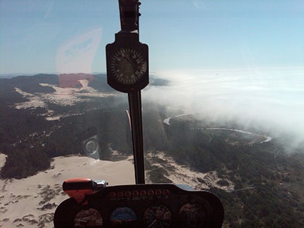
Here’s a shot of the marine layer on the coast of Oregon that forced us inland during a flight from Seattle to Wickenburg with my wasband in 2009.
My experience with flying the coast was varied. What I’d learned was that if I could get to the coast, I probably wouldn’t be able to follow it all the way up. The California and Oregon coasts are well known for their “marine layer” clouds. Although I’d flown the coast many times in the past, from Los Angeles to the Columbia River between Oregon and Washington, those damn clouds always made an appearance, forcing me inland so I’d never covered more than one or two hundred miles at a stretch. Last year, when I’d flown north by myself, planning on a coastal route, clouds with rain moved in not long after I hit the coast, forcing me inland for a dreary flight with more scud running than I like to do.
But nothing ventured, nothing gained, eh?
We followed Cache Creek west into the hills. I did the flying. I’d been wanting to fly Cache Creek all winter, but truck troubles had messed up my March plans and I wound up spending most of the month home instead of with the helicopter. I hadn’t flown nearly as much as I wanted to. This was my chance to get flying out of my system, flying a familiar and loved route. Somewhere in the hills, I turned the controls over to Don and he steered us over Clear Lake. Although the weather was clear where we were, there were clouds to the west (of course) and neither of us were sure whether they came into the coast or were off over the Pacific.
After flying up Highway 101 for a while, we decided to try heading west to see if we could make the coast. So we followed one of the canyons — I’m not sure, but I suspect it was the one the Noyo River flows in — concentrating on the path ahead of us. As expected, we were moving right in toward the clouds, which forced us lower and lower. But ahead of us, to the northwest, the sky was bright. Maybe it was clearing up?
We were flying about 300 feet over the road, stretching our necks to peer ahead of us and ready to turn around as the road went around a bend at a high point in the hills. We followed the bend and the road dropped away. We kept going.
Low clouds kept us flying low in the hillsides near Fort Bragg. We turned north, heading for our first fuel stop at Eureka. The coast was to our left and we occasionally caught glimpses of it as we flew over tree-covered hills with the clouds only a few hundred feet above us. I don’t think either of us wanted a trip up the coast in such conditions — I know I didn’t. But I also didn’t want to fly the I-5 corridor, which is painfully boring, especially once you get north of Eugene. We’d make a decision at Eureka.
The ceilings were much higher when we stopped for fuel at Eureka. We gassed up; Don bought the first tank. Then we went inside for a potty break. There wasn’t much else to do there — although the airport has a nice little pilot shop, there was no restaurant and nothing was within walking distance. So we climbed back on board and continued on our way, this time following the coast.
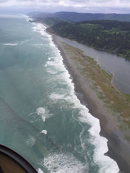
Despite the clouds, it was beautiful on the coast.

If you’ve driven on the Pacific Coast Highway — Route 101 — through Brookings, CA, you’ve driven over this bridge.
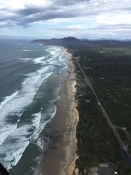
The coast near Newport, OR. I love the way the breakers line up when you see them at just the right angle.
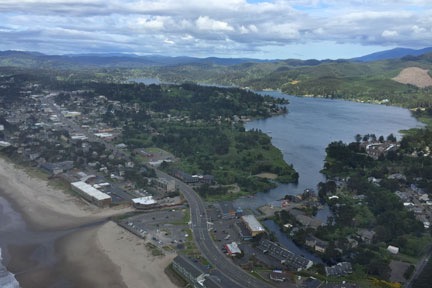
A look down into Lincoln City, OR.
By this time, the scenery around us was interesting enough to take some pictures while Don flew. The doors were on, of course, so most of my photos have reflections and glare and even window dirt. But they give you a feel for what the weather was like and show a little of how beautiful the California and Oregon coasts can be from about 500 to 1000 feet up.
The coast was very rugged at the beginning, where the Redwoods National and State Parks come right up to the rocky shoreline. There were no roads in many places — just trees right up to the cliffs with lots of small waterfalls dropping down into the ocean. This is a view few people see, a view that can only be seen from the air off the coast. Don steered us along its left, over the ocean, just within gliding distance of land.
In some places, we saw sea lions stretched out on rocky beaches. I took pictures, but they didn’t come out good enough to share.
The Pacific Coast Highway hit the coast and then went inland several times. Finally, just before we hit the Oregon state line, it came out to the coast and stayed there for quite a while.
The weather got a little worse at first, with light rain pelting the cockpit bubble in more than a few places, then started to get better. By the time we got into Oregon, we saw patches of blue sky. The sun was shifting ever lower toward the horizon to the west and the light started getting kind of good.
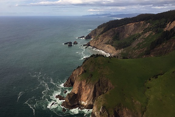
Light is 90% of photography.

Waterfall near Otis, OR. Yes, I cropped this image; we weren’t that close.
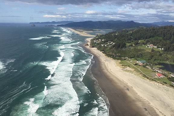
Cloverdale, OR looks like a pleasant place to live, eh?
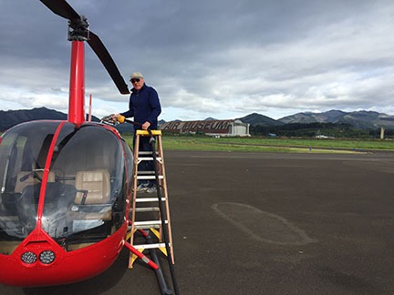
Don fueling up at Tillamook. The huge hangar behind him was used for airships years ago. I think there’s a chance it might be an air museum now.
We made our second fuel stop at Tillamook, OR. Don pumped while I paid. It was just after 5 PM and the airport office (and restrooms) were closed. It was also chilly. I let Penny loose to do her business, then called her back to get back on board. We didn’t hang around.
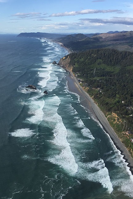
The Oregon Coast near Seaside.
By now, we were hungry. Two breakfasts had filled us before noon, but skipping lunch hadn’t gone unnoticed. Don had been texting back and forth with his wife who would have a hot dinner waiting when we arrived at their Seattle area home.
We continued up the coast a bit more before heading inland not far from Astoria, where the Columbia River meets the Pacific Ocean. This was, by far, the longest stretch of the Pacific Coast I’d flown in one day: more than 400 miles.
Don navigated northeast toward his house. It was all familiar territory to him — I didn’t fly much west of the Cascades. We flew east of Olympia and right over the top of the airport at Puyallup. From there, it was only a few minutes to Don’s place.
My iPad, with Periscope running, broadcast the approach in typical low-def quality.
Don let me take the controls and guided me in. I’d flown to his house before a few times but honestly couldn’t remember much about the approach. He had to keep pointing out landmarks and reminding me to slow down. It is tight — that’s for sure — with a steep approach between tall trees into a clearing beside his garage. I had Periscope running on my iPad in its cradle and recorded the whole thing.
And then we were on the ground, the long part of my journey over.
Resting Up
We went in and had something to drink while Don’s wife, Johnie, finished making dinner. Penny played with their new dog and ran around their grassy yard occasionally taking a detour to terrorize their chickens through the fence.
After dinner and a nice dessert, I went out to the barn with Don to see the two cows they’d “rescued.” They were huge. I really wish I’d had the presence of mind to take a photo, but I was so shocked by what I was looking at that I simply didn’t think of it.
I hit the sack in the guest room pretty early. I was still fighting a cold I’d had for at least three weeks and was exhausted. I slept well with Penny at the foot of the bed.
Seattle Area to Wenatchee
In the morning, after letting Penny out and then taking a quick shower, I dressed and met my hosts for breakfast. It was overcast and questionable (as usual) as to whether I’d make it across Snoqualmie or Stampede Pass. The automated weather station at Stampede was reporting half-mile visibility, which was enough to get through legally. But what about the rest of the flight? There was no accurate weather reporting in other places in the mountains. The only way to find out whether I’d make it was to give it a try. If I couldn’t get through, it was a long flight around the Washington Cascades to the Columbia River Gorge. I was hoping I wouldn’t have to go that way.
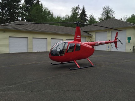
Another cloudy morning at Don’s place.
After thanking my guests and saying goodbye, I did a quick preflight, added some oil, and climbed on board with Penny. Then I started up and warmed the engine, setting up my iPad and iPhone with weather resources and Firelight maps to guide me while I waited. When the helicopter was ready to go, I picked up into a hover, turned 180 degrees over the driveway, and climbed out through the trees the way I’d come.
I had ForeFlight’s track log feature enabled during the flight, so I know exactly how I went. Originally, I thought I’d hook up with I-90 and follow that through the mountains at Snoqualmie Pass, which is at 3004 feet. But that would require me to head north quite a bit before heading southeast. It didn’t make sense to go out of my way. So instead, I followed the course of the Green River up into the mountains, aiming for Stampede Pass, which is higher at 3800 feet, but had that handy ASOS weather station. The weather there was reported at 1/4 mile visibility with mist, but I knew that could change at any time.

An overview of my route from the Seattle area to Wenatchee. Not exactly a straight line.
In the meantime, the flight was pleasant, even under the clouds, taking me over the Howard A Hanson Reservoir and a few communities that were no more than named points on the map. The area below me was thick forest, for the most part, with a road following the river for part of the way. I wish I could have taken pictures, but I’m a terrible photographer when I’m flying. I really missed my GoPro on that flight.
I steered up another canyon to the left just past Lester, heading for Stampede. The only roads were forest roads now as I climbed with the hills, getting ever closer to the cloud bottoms. Soon, I could see Stampede Pass ahead of me. I’d forgotten all about the wires that crossed through the lowest (and clearest) spot. I’d have to cross at a higher point a bit east where the clouds seemed to touch the ridge line. I could tune into the ASOS by that point; it was still reporting 1/4 mile visibility with mist.
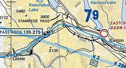
Here’s a closeup of my route (the blue line) through the Stampede Pass area on a Sectional Chart. I crossed the mountains just southeast of the pass, not at all interested in crossing over all those wires.
I slowed to 40 knots and creeped up to the ridge. I knew the rules I’d set for myself, rules that had never failed me when dealing with weather flying: if I could peek over the ridge and see the ground and my path ahead, I’d cross the ridge. Otherwise, I’d have to backtrack or find another place to cross.
I peeked, I saw. The ground dropped away ahead of me as I crossed the ridge near the pass and descended down into the valley beyond. Soon I was flying over I-90, past the lakes near Roslyn and Cle Elum. I steered east northeast, then due east, then northeast, direct toward home.
I crossed the mountains south of Wenatchee at Mission Ridge and made a slight detour to check out the slide damage areas at Whispering Ridge and Joe Miller Road. Then I made a beeline for the airport to get some fuel and take care of some paperwork with my mechanic.
A short while later, I was landing on my platform, which I’d left outside before heading down to Sacramento the previous day. It was good to get the helicopter put away.
Discover more from An Eclectic Mind
Subscribe to get the latest posts sent to your email.

I love that coast. From Point Reyes above San Francisco it just gets better and better, right up to Tofino on V.I.
We have had some wonderful times along that route.
Great shots of the coast, thanks.
(Do canines get special treats if travelling in the ‘first’ cabin on Alska Air?)
I flew the coast past San Francisco once. The weather moved in at Half Moon Bay and we were forced up to 3,000 feet. SFO’s ATC guided us through their busy airspace. We flew over the Golden Gate Bridge and got some neat (but glarey) images of the bridge with one tower in the fog. It was an amazing flight that I really enjoyed.
Penny doesn’t fly first class. She flies under the seat in front of me. 95% of the time, no one even knows she’s there. Works best for all concerned.