It’s Worth the Extra $58.80 per Month, Right?

I bet the driver doesn’t think so.


Take a drive on dirt for the last 1/10th mile to my house.

As I’m typing this, I’m watching the town’s garbage collection truck rumble down the unreasonably steep and rugged road that leads to my home and my two neighbor’s homes. This is the third time the driver has come down the unmaintained road and he hasn’t quite gotten the hang of it yet. The loose rocks slip under his wheels on the way down and move aside to make deep ruts on the way up. His round trip from the last house on his route to our three garbage pails takes him about 15 minutes each day. He does this twice a week.

But that’s what the Town of Wickenburg wanted, I guess.

Four years ago, they annexed our three homes, against our will, into the Town. Apparently shopping and operating businesses in town wasn’t enough for our land-hungry mayor (who has since, thankfully, been defeated by someone who isn’t quite as obsessed with empire building). They wanted our property taxes, too. It didn’t matter that they weren’t interested in providing additional services for those tax dollars. The road to our homes remains unmaintained, there’s still no fire hydrant within at least a half-mile, we can’t get cable or DSL or town water or sewer services. They assure us that the town’s police and ambulance will come to our homes when called, but none of us have tried that yet. I don’t think they’ll find us. They gave us all new addresses, putting us on a street that apparently doesn’t exist — there’s no sign for it anywhere. My neighbors may have taken the hit of a “move” on their credit reports, but we didn’t — we changed our address right back to what it was.

But it’s worse for the rest of the folks annexed with us. They were promised that their road would be paved. That’s why they voted yes for the annexation, dragging us in with them. Their road remains unpaved to this day.

About two weeks ago, the Town added yet another insult. The town lawyer, who really ought to consider going into a different line of business, sent us a letter telling us that we were in violation of some town code because we didn’t have a contract with the Town for garbage pickup. The letter threatened legal action, with a daily fine of $300 or so dollars a day. The letter was nasty and accusing — as if we were purposely denying the town $19.60 per month of revenue.

I don’t take kindly to threatening letters. I got seriously pissed off and started making some angry phone calls.

Turns out that when the Town annexed us, the letter they sent to inform us of all the changes we could expect — like our new address — also told us that garbage service was available from the town. I don’t have the letter anymore — I tossed it long ago — but I don’t recall the letter saying garbage pickup was required. There’s a big difference, especially to a writer, between available and required. We already had garbage pickup from the local sanitation company and it was cheaper, so I didn’t see any reason to make the change.

My call to Town Hall got me many apologies from the person I spoke to. She told me they’d gotten a lot of complaints about the lawyer’s letter. I’m glad. It means that I’m not the only person who gets angry when some idiot backwoods (or back desert, in our case) lawyer flexes her fingers without thinking on a word processor’s keyboard. Apparently, the townspeople aren’t quite as lifeless as I thought they might be.

Since garbage pickup with the town was now roughly the same cost as with the private company and they’d come pick up twice a week rather than just once, we signed up with the town. It’s unfortunate for the other company. If they keep losing business to the town, they’ll soon go out of business. But heck, what does the Town of Wickenburg care about the viability of local businesses?

So now the garbage truck lumbers down our steep, rutty, loose gravel road twice a week to collect garbage from three pails. We make very little garbage because we recycle so much — and no, they won’t pick that up — so they’re not collecting much from us on every visit. The truck crawls back up at 5 to 10 miles per hour, spinning its tires once in a while to dig one or two new ruts that it’ll have to drive back over a few days later.

After the next rain, my neighbor will pull out his Bobcat and scrape down the road surface. My other neighbor will drive up and down with a home-made smoothing bar — think railroad steel and chain link fence dragged behind a pickup truck. We’ll do our part by driving up and down the hill at 15 miles per hour without stopping or with 4WD turned on in our pickup — the only way to avoid making ruts.

And the town will collect an extra $58.80 per month in revenue for the 2 extra hours it takes its truck and driver to include us on the route.

Finding a Legal Landing Zone

It’s not as easy as it seems sometimes.

At Lake Pateros
My R44, parked on the side lawn at the Lake Pateros Inn in Washington State. Sadly, heat from my engine browned the grass.

One of the benefits of operating a helicopter is that you can land it almost anywhere. One of the drawbacks of this, however, is that not all landing zones are legal.

The other day, I was asked by a client to find a pickup location for him that was closer to where he was staying than Scottsdale Airport. He suggested two possibilities that I knew I couldn’t use:

  • A private helipad at the resort where he’s staying. That helipad is owned by another helicopter operator who gets three times what I do per hour of flight time. They do not allow others to use their helipad.
  • A private, residential airport near the resort where he’s staying. They have a strict “no helicopter” policy.

I went through the motions and called the managers of both facilities. I was told what I expected to be told: that I could not use them.

What Do the FARs Say?

Around this time, I commented on Twitter that I was conducting a search. Another pilot, who flies airplanes, wanted to know how I was searching and where legal landing zones were covered in the FARs (Federal Aviation Regulations).

The truth is, they’re not. There’s no FAR that clearly states where you’re allowed to land a helicopter.

Instead, the Aeronautical Information Manual (AIM) offers some clear guidance on where you’re not allowed to land any aircraft. 7-4-6 Flights Over Charted U.S. Wildlife Refuges, Parks, and Forest Service Areas states, in part:

The landing of aircraft is prohibited on lands or waters administered by the National Park Service, U.S. Fish and Wildlife Service, or U.S. Forest Service without authorization from the respective agency. Exceptions include:

1. When forced to land due to an emergency beyond the control of the operator;
2. At officially designated landing sites; or
3. An approved official business of the Federal Government.

I assume this is in the FARs somewhere — the AIM is generally a plain English translation of most FARs, better organized and easier to read — but I can’t track it down.

So Where Can You Land?

A Heli Outing
This heli-outing brought three helicopters, including my old R22, out in the desert near the Swansea Townsite.

When I first started flying helicopters, knowing where you were allowed to land in a non-emergency situation was a big deal. Everyone dreams of landing on their best friend’s driveway or backyard. Was it legal? How about showing up at your kid’s soccer game? Dropping off a friend at work in an office park? Stopping in at Krispy Creme for a donut and coffee? Landing along the lakeshore for a quick afternoon swim?

Is any of this legal?

My answer: it depends.

Before you read any farther, understand that I am not a lawyer. I cannot advise you on these matters. If you get in trouble for landing somewhere and use what you read here as a legal defense, you are an idiot and deserve to lose your license. I’m just sharing what I’ve learned through experience. I don’t know all the answers and certainly cannot advise you in your specific situations.

Landing in the Middle of Nowhere

R22 in Riverbed
A blast from the past: My old R22 sitting in a wash south of Alamo Lake about a day after it flowed. Hard sand makes a good landing surface.

Keep in mind that I live on the edge of nowhere. Wickenburg is on the northwest end of Maricopa County. There’s not much other than empty desert in most directions. Go southeast and you’ll get to the Phoenix metro area within 30 minutes, but go in almost any other direction and you’ll be driving (or flying) for a while before you get anywhere else.

That said, friends and I have landed our helicopters at many remote patches of desert, both privately owned and owned by the Bureau of Land Management (BLM).

I discovered through telephone calls, an exchange of mail, and a $270 fine that I’m allowed to land on BLM land that’s not Wilderness area as long as I don’t do it with paying passengers on board. Commercial flights must have permits for landing on BLM land. And trust me: BLM will drag its collective butt in getting you a permit once you apply for one. It took 18 months for me to get permission to land at the Swansea Townsite and costs $90/year to maintain that permit. (I’ve landed there once with paying passengers in the past three years; do you think I should renew?)

But land on private land just footsteps away from government-owned land and you’re okay — as long as other factors don’t come into play.

Permissions and Local Ordinances

At the Big Sandy Shoot
Parked at the semi-annual Big Sandy Shoot. The event is held on a mile-square parcel of privately-owned land northwest of Phoenix.

What are the other factors?

Well, you need to have permission of the property owner. After all, it is his property. It doesn’t have to be written permission, but if you don’t have permission, you could be prosecuted for trespassing.

You also need to be aware of any local ordinances against landing. Wickenburg has one of these ordinances, although they only seem interested in enforcing it when it’s convenient to them. (This is the case with many of Wickenburg’s rules, especially those regarding zoning.) Scottsdale also has an ordinance.

Moab, UT didn’t have an ordinance until after I landed at a friend’s 2-1/2 acre property there. The cops rolled by and I thought I’d get in trouble, but they just wanted to see the helicopter. A week later, the ordinance came out and was on the front page of the local newspaper. Oh, well.

There are two ways to find out if a locality has an ordinance against helicopters landing within town limits:

  • Land there and see if you get in trouble. I don’t recommend this approach, but it can be effective, especially in remote areas where you might not even be seen by anyone on the ground.
  • Call ahead and ask. In most cases, they won’t know. You can make a lot of calls and get nowhere. Then you can try the above approach and see where it gets you. Hopefully, not in jail.
Helicopter at HouseParked in the desert north of Phoenix. Photo by Jon Davison.

Of course, this refers to towns and cities. Within those are subdivisions that may be controlled by written rules (such as that private airport that won’t allow helicopters). And everything is inside a county, which may have its own rules.

Sounds like a pain in the butt? It is. But if you don’t do your homework before you land off-airport, you’re liable to get in deep trouble with the local authorities and FAA. You could have your pilot certificate suspended or even revoked. I don’t know about you, but I have enough time and money invested in my helicopter pilot certificate, aircraft, and business to act wisely. If I can’t find a legal landing zone where I think I need one, I won’t land there.

Please Read This

Tristan's R44
Before buying my own R44 in 2005, I leased a friend’s. This shot was taken in Congress, AZ, where I attempted to sell helicopter rides a few times.

If you’re landing off-airport, whether you have permission to land at an official helicopter landing zone or you’re just taking a risk landing where you might or might not be allowed to, please, for the sake of all of the helicopter pilots out there, keep these things in mind:

  • Only land where its safe. This applies to the terrain of the landing zone itself, as well as your approach and departure routes. Wouldn’t you be embarrassed if you had a dynamic rollover in your buddy’s backyard?
  • Land at the edge of activity — or farther away, if possible. I used to do rides at the Mohave County Fair. My landing zone was at the far end of the event, beyond the carnival rides. There were many people at the event who didn’t even know there was a helicopter around. I’ve also landed at remote restaurants far enough away that no one even heard me approach.
  • Only land where you can secure the landing zone while the helicopter is running. I’ll land places where there may be people on the ground if I have a second person on board with me to get out and keep the landing zone clear of curious bystanders. But if I’m alone, I wouldn’t even think of landing where someone might approach the helicopter while it’s running. Do you really think it would be a good idea to land at your kid’s soccer game? What if a bunch of those kids ran toward you from behind and ducked under the tailcone? Do I have to paint a bloody picture for you?
  • Do not overfly people, vehicles, animals, or buildings at low-level. This is for courtesy and safety. Engine failure on approach or departure means a possibly messy crash into whatever’s below you. Crashing into an empty parking lot is very different from crashing into a crowded soccer field or county fair arcade. (By the same token, anyone who buys a home within a mile of the approach/departure end of any airport runway should have his/her head examined.)
  • Be courteous to people on the ground. Don’t spend more time than necessary circling the landing zone at low level. Once you know your approach and departure routes, get it on the ground. Don’t give bystanders a reason to complain. That’s why localities make these ordinances. Because some jackass pilot annoyed just the right number of people to get the ordinance voted in.
  • Do not draw attention to yourself. Sure, it’s cool to land off-airport and yeah, everyone will be jealous. But aren’t you above all that? If you can land and depart in such a way that no one even knows how you arrived, that’s even cooler.
  • Do not walk away from the aircraft with the engine running and blades spinning. I can’t believe I have to include this no-brainer on a list, but here it is, for the folks who have no brain and actually leave a running helicopter unattended.
  • If asked to leave, do so quickly and without argument. Be apologetic. Be nice. Don’t be an asshole.

The rest of us are depending on you to act wisely so the FAA doesn’t add a rule that prevents us from landing off airport.

My Advice

Mansion Landing
Parked at the house of some friends just outside Wickenburg town limits. They cleared a small helipad up there for me to use. Photo by Jon Davison.

My advice is that you don’t land anywhere where safety or legality may be an issue. Do your homework and get the information you need to establish whether your landing zone is legal.

Or simply land at the nearest airport. That’s what I’ll be doing for my upcoming charter flight.

Quicksand!

I went looking for quicksand yesterday afternoon — and found it.

Quicksand is quite common along the Hassayampa River in Wickenburg. The river runs mostly underground, in the sandy river bed. It comes to the surface in rocky areas, like around Box Canyon and south of town. It also flows on the surface when there’s a lot of water — like during or after a heavy rain.

It had rained earlier in the week and there was snow on the Bradshaw Mountains, where the Hassayampa has its source. The river was running too big to drive in. So we took Scenic Loop around to one of the few dirt roads that winds down to the river. We parked on a hill and hiked down to walk along the river’s edge.

One of the places quicksand likes to form is at the base of large rocks or cliffs that end in the water. The water flows downstream, hits these rocks, and makes a kind of eddy before it turns one way or the other and continues downstream. Where it makes the eddy, the sand gets soft. Very soft. There’s lots of water under it, so even though the sand looks firm on the surface, when you step into it, you’ll sink in.

I was exploring one of these areas on foot with my video camera on a monopod/walking stick. I was getting to the point where the sand was just a little soft and I stretched out my left foot to feel the next step ahead. It seemed firm enough, so I shifted my weight onto it. Bad move. I sunk in past my ankle. Thrown off balance, I put my walking stick down nearby. It also sunk in. Before I could fall forward into it, I threw myself backwards, landing on my butt in the soft, wet sand.

QuicksandFor a moment, I considered panicking. Then I realized how dumb that was and inched backwards on my butt, pulling my feet and walking stick with me. After a few moves, I was on firm enough sand to get back on my feet.

Right after my incident, Jack the Dog wandered into the same spot, chasing a bee. He reacted quickly and managed to get out without assistance — he’s been in quicksand before — but it was interesting to see the sand shift and recover its innocent appearance after he’d escaped.

The photo here was taken when we got home. My left foot is still wet and sandy; my right foot is dry and clean. Sorry — no photos of my sandy, wet butt.

Quicksand is a serious thing along the river and not to be taken lightly. If a vehicle drives into it, it can quickly be sucked down to the point where it can’t be pulled out.

As for the dry quicksand of television and movies — I don’t think it exists. This stuff is wet and clingy and sticks with you until you change your clothes.

A Vulture Peak Hike

Another trip up the mountain.

On Sunday, Mike’s cousin and his girlfriend were in town from Seattle. They were bummed out because of the weather — it was rainy with low clouds — but we desert-dwellers were thrilled. We’ve had quite a bit of rain this winter and the desert is lush and green — or as lush as a desert can be, anyway. Every time it rains, we think about how much greener the grass between the cacti will get and how incredible the spring flowers will be in another month or so.

They wanted to do something and we wanted to do something outdoors. So we geared up with hiking boots and jackets and water bottles, packed ourselves into my Jeep with Jack the Dog, and drove out to the Vulture Peak Trailhead, which is about 7 or 8 road miles from our house.

Vulture Peak is the tallest mountain in Wickenburg and, indeed, the tallest peak in the immediate vicinity. It’s the remains of a volcano and has an odd shape that gives it a completely different look depending on what direction you’re viewing it from. From our house, it looks like a tall knob. But from the main trailhead parking lot, it looks like a wide rocky butte.

It was still raining when we drove through the main trailhead parking lot and continued on the 4WD road to the trailhead at the foot of the mountain. To get there, we had to drive down a very steep, very eroded embankment. I’m too cowardly to drive down places like that, so I climbed out and Mike climbed in behind the wheel. He threw it into 4 low and crawled down the hill, letting one wheel and then another hang in the air while the rest of the wheels did all the work. At the bottom, I climbed back in behind the wheel and we continued on the way.

In the Jeep
My Jeep, Packed to the Gills.

The rain — a steady drizzle — let up when we reached the second trailhead. I parked and we tumbled out. My Jeep is a 4-seat Wrangler and it was packed to the gills with the four of us and a 55-lb dog. Good thing I had the doors and back windows off to give us breathing room.

Above us, the clouds were moving briskly from south to north. It was about 10 AM and the sun was trying hard to break through the low clouds. It looked promising. We started up the trail toward the saddle.

I’ve written extensively about Vulture Peak for wickenburg-az.com. That piece, originally written in 1999, is accompanied by the tiny photos the Web site supported back then. One of my goals on this trip was to take some better photos to share on the site, and possibly include in my Photo Gallery. So I had my Nikon D80 with me, as well as two lenses: my 16-85mm zoom and my 10.5mm fisheye.

My companions quickly got a lead on me up the steep trail. I’m miserably out of shape these days, but I never did do well on uphill climbs. Sure, I can do downhill on a trail all day long without lagging, but point me up a hill and be prepared to wait. I’ll get there — eventually — but I need a lot of rest stops along the way.

Hike View
A view from the start of my hike.

I took the opportunity to shoot some photos as I hiked. The brightening desert was all around me and, as I walked, the sun poked out and cast its bright, warm light here and there. And then there was the novelty of wet rocks and drops of water on the cacti. And puddles. Do you know how seldom we see puddles out in the desert? That day, they were all over the place.

Soon I was alone on the trail, huffing and puffing as I hiked upwards. The trail is probably rated as intermediate difficulty from the second trailhead, where we started, to the saddle. (It’s probably rated easy from the first trailhead to the second; a nice 1-1/2 mile stroll on a narrow pathway through the desert.) It’s not a long walk, but it’s steep. After an initially easy straight climb, it zig-zags up the mountain on a series of narrow switchbacks neatly carved into the terrain.

On Vulture Peak Trail
On Vulture Peak Trail.

I was upset to see that some hikers had inconsiderately cut corners, creating “shortcuts” of crumbling rock trails. I was also bothered by the sight of uprooted penstemon — one of the few wildflowers already in bloom — tossed aside on the trail. Who would tear wildflowers out by the root? And why? Apparently there are people out there with far less appreciation for the desert than we have. Perhaps they should have stayed home in front of their TVs and video games and left the plant life alone to grow and multiply.

Within an hour, I was near the saddle where the trail opens up to a wide area offering views in two directions. On one side, to the north, is the rocky peak of the mountain. On the other side, to the south, is a series of secondary peaks that reach up to the sky with jagged, tooth-like edges. I fully expected to be alone there, too. The summit was a short but difficult steep climb away and I assumed Mike and his companions would have made the climb by then. But they were there, waiting for me. Our out-of-town visitors had been spooked by the hand-over-hand portion of the climb and had decided the saddle was far enough up the mountain. That’s unfortunate because the view from up there is 360° and, on such a clear, crisp day, would have been breathtaking.

View from Vulture Peak Trail
View from near the top of the Vulture Peak trail.

I rested up, snapping photos with my camera. I soon realized that exposures would be a problem and used bracketing to ensure I’d get at least one shot out of three that was properly exposed. (What did we do before we had digital cameras? Waste film? Waste time in a darkroom? Waste photo paper on crappy shots half the time?)

We hiked around a bit in the saddle area, then went to explore the areas around the secondary peaks. I’d never hiked up that way. It wasn’t much of a hike, but there were no real trails. We each made our way separately. Occasionally, I’d hear the voices of my companions or see Jack the Dog scampering around the base of a rocky mound.

Looking Southeast Between the Peaks
Looking southeast between secondary peaks.

I climbed up to a point between two rocks and was instantly struck by the view of the line of peaks with the sun full on their wet rocks. I snapped a picture quickly, sorry that I had my fisheye lens on the camera. I switched lenses as the sun hid behind a speeding cloud again. I remained rooted in that space until the sun returned and I could snap a few more shots. Mike joined me and we watched the ever-changing show of light and shadow on the rocks, cacti, and flat desert terrain beyond.

At our feet were geode-like rocks with crystals. I’m sure someone with a knowledge of geology would find them very interesting. Mike picked up a small piece of crystal to show our companions, who had already started back down the trail.

Vulture Peak Trailhead
The Trailhead at the Foot of Vulture Peak.

The hike down was much quicker for me — as it usually is — and we were back at the Jeep within 30 minutes. I paused to take a photo of the peak from the trailhead. This wide angle shot throws things out of perspective a bit, but it gives you an idea of the terrain and destination. The “saddle” is the area in the “V” of the mountain, where that big, puffy cloud is. The main peak is the one on the left; the secondary peaks, which are shorter, are to the right.

We drove back to the main trailhead and I successfully steered the Jeep up the steep, eroded road. (Somehow, up isn’t nearly as scary as down.) The parking area was just as empty as when we’d arrived. Evidently we were the only people who would experience the incredible beauty of this desert mountain right after a winter rain.

Related Links

Here are a few other articles and blog posts I’ve written about Vulture Peak, as well as a link to a slide show of my Arizona images.

On An Eclectic Mind:

On wickenburg-az.com:

On Flying M Photos:

PhotoJeeping: Mine Ruins on the Hassayampa River

Some photos from a real off-road experience.

This past Sunday, Mike and I took the Jeep up the Hassayampa River. Way up the river.

As folks around Wickenburg know, the Hassayampa is mostly dry. The water does flow year-round, but in most places, it’s below the sandy surface. In rocky areas, it flows above the surface as a small stream.

Unless it’s rainy (or has been rainy). Then it’s a real river and should not be driven in.

Our Route InOn Sunday, it was running only slightly higher than usual. We entered the riverbed near the end of Rincon Road, where it climbs up to meet Scenic Loop. There was an old manganese mine there and the dirt road is black. Going straight (instead of making the left turn) takes you on a narrow track to the river. From there, it’s just a matter of following the tire tracks left by other vehicles.

Slot Canyon
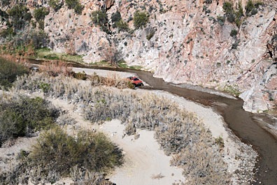
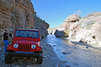
We made a few brief stops. Box Canyon was one of them. But there were motorcycles there with loud engines and we didn’t stay long. Instead, we continued upstream, into the narrow slot canyon. The water flowed from wall to wall within the canyon and I had the windshield wipers going as I slipped around in the soft sand. We stopped for a moment to take a photo of the way we’d come.

We passed through the first gate just short of Boyd Ranch, above the floodplain on our left. We passed through the second gate just before Fools Canyon. Right about there, a group of five sand rails (dune buggies) and a yellow Jeep caught up with us. (We weren’t rushing.) We pulled over to let them pass.

In many places, four wheel drive was required. So was high clearance. So unless you have a Jeep or similar vehicle or an ATV, this isn’t the kind of drive you’d want to make. You’re driving in the river, with water splashing up all around you, in many places. There’s quicksand there, so you want to keep moving anywhere the sand is soft. Gnarly tires are definitely a plus.

Desert Meets StreamWe passed many interesting spots where Sonoran desert meets year-round stream. The variations in the rock were amazing. I took quite a few photos. Some of them are in my Photo Gallery.

We were about two miles past Fools Canyon when the group that had passed us came back. One of the drivers stopped to report. “You can’t go much farther,” he said, “but it’s worth it. There are some old foundations up there.”

Mine Site
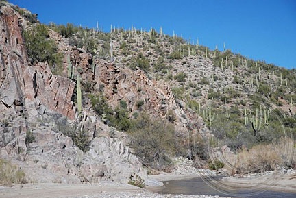
We continued on. The river was flowing through a canyon, but the way was still passable. We soon saw the remains of a mine site on the right side of the hill. We turned the Jeep into a promising canyon where other vehicles had driven but soon reached a dead end where rocks blocked our way. We parked, got out, and hiked up the hill.

It was an interesting mine site, with some seriously heavy-duty foundations. I don’t know much about mining, but I do know that they used gravity to process the ore. That’s what most of the “foundations” were for.

Tunnel
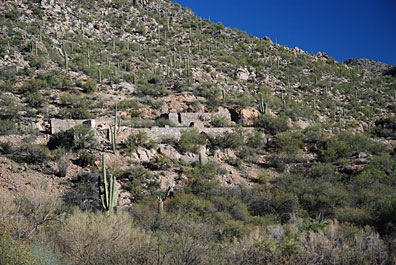
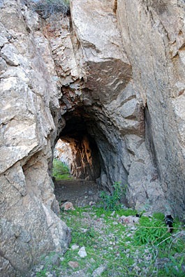
Following a narrow path for a better view down into the river, I came across a tunnel carved into the solid granite at the side of the hill. We passed through and continued onto the other side.

Mine RuinsA bit farther down the pathway, we found the remains of a wooden mining structure, as well as some partially buried railroad steel. Evidently, the path and tunnel had been used by ore carts or some similar conveyance. Most of the steel had been removed; the one piece we saw had been buried under a rockslide.

Truck in the River
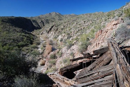
As we admired the view, we heard the sound of a vehicle. Down in the riverbed, a truck was driving downstream. It stopped only long enough for the driver to point out a mine shaft to his passenger, then continued on down the river. I don’t think they saw us or our Jeep.

We left a while later and spent a short time exploring the severely vandalized remains of a home across the river. Then we headed back, stopping long enough to take a few photos along the way.

We were gone about five hours and had covered about 40 miles roundtrip. We took Scenic Loop from just past Fools Canyon on the way back, minimizing our time in the riverbed.

I checked all the maps I have for the area and the mine does not appear on any of them, so I don’t know it’s name. I do know it well, however; I fly over it every time I take a tour up the Hassayampa River in my helicopter. It’s nice to know what it looks like close up.