Helicopter Flight: Fog in the Cascade Mountains

A cockpit POV video from the FlyingMAir YouTube channel.

Sit on the nose of my old helicopter as I fly over the Cascade Mountains and its fog-filled valleys. There’s some narration in the beginning; you can apply your own music.

This “Flashback Friday” video is an 11-minute clip from about 90 minutes of footage shot from takeoff in Wenatchee Heights (WA) to landing at Hillsboro (OR) Airport in July 2012. The flight was done on one of those very rare occasions when I could fly a direct, straight line route – normally, there are low clouds in the Cascades that force me to go around them to the south. You can find a montage of clips from the entire flight in a video I released back then, “Helicopter Flight from Wenatchee to Hillsboro” at https://youtu.be/hnIbY2y69Ug.

I remember this flight like it was yesterday. I had to take the helicopter to Hillsboro for a 100-hour inspection and needed to rush back to Wenatchee to finish cherry season. In this segment, I’m flying over the Cascade Mountains and the valleys below me are full of fog. I had taken off just after dawn and the mountain ridges cast long shadows ahead of me. It was absolutely gorgeous.

Back in July 2012, my divorce had just begun and it wasn’t in its crazy ugly stage yet. At this point in the flight, I recall thinking how much my future wasband would have enjoyed the flight and I was sad about that. (Now I can’t help thinking what an idiot he is and how much better off I am without him. Oh, well. Time does heal all wounds.)

I was also a little uneasy on this part of the flight. Flying VFR on top – which means flying in visual flight rules conditions over clouds – is not something I do very often. Helicopters normally fly quite low and I’m seldom above the clouds. I remember being surprised to see the fog and then nervous with the realization that if I had to make an emergency landing I wouldn’t be able to see my landing zone as I descended. But isn’t all that fog just wonderful to behold?

This was also memorable because it was Penny the Tiny Dog’s first helicopter flight. She was about 5 months old at the time and I had no idea how she would react. I put her in the front seat on a leash that would prevent her from getting into my controls. But after I started up, she just curled up in her bed on the seat and went to sleep. She slept until I began my descent at Hillsboro.

About Me and the Helicopter

  • I have been flying for about 20 years. My nearly 4,000 hours of flight time is in Robinson R44, Robinson R22, and Bell 206L (Long Ranger) helicopters.
  • The helicopter is a 2005 Robinson R44 Raven II — the same one that appears in the photo at the beginning of the video. This was my first R44, which was lost in a crash back in 2018. You can learn more about R44s here: https://robinsonheli.com/r44-specifications/ I owned this helicopter and now own another one very much like it, but blue. I’ve owned a helicopter since 2000.

About the Video

  • This video was recorded in 2012 with a GoPro Hero 3 camera mounted on the nose of the helicopter. Audio comes from the camera’s built-in speaker and has been incorporated into this video at 20% normal volume.
  • The video was stabilized prior to editing in iMovie software. Although I don’t like to edit in iMovie, it does have decent stabilization. If you compare this video to more recent nosecam video (for example, “Helicopter Nosecam Flight: Dawn on the East Side of the Cascades #2” at https://youtu.be/HXBznbtc54U), however, you’ll see that a GoPro Hero 7 Black shoots much more stable video than a Hero3.
  • Narration was done using a Røde Podcaster microphone (https://amzn.to/2IFnbNr) connected to a Macintosh. I recorded the brief narration while I was watching the video in the editing software.
  • The video was edited on a Macintosh using Screenflow software. Learn more about it here: https://www.telestream.net/screenflow/overview.htm
  • The intro music is by Bob Levitus, famed “Dr. Mac.” You can find him here: http://www.boblevitus.com/

I try to drop cockpit POV videos every Sunday morning and “extras” with more info about owning and operating a helicopter midweek. (Some channel members get early access to some of these videos.) I also host occasional livestreams with Q&A chats. Subscribe so you don’t miss anything new! And tell your friends. The more subscribers I have, the more motivated I am to keep producing videos.

Any Amazon links on my channel are affiliate links (https://amzn.to/32PLHTD). If you click one of them and buy something, Amazon sends me a few pennies. Enough pennies make a dollar. Enough dollars buy new equipment. It doesn’t cost you anything so I hope you’ll shop with one of those links. Thanks.

Still reading? Thanks! Maybe you’ll consider buying something from my Etsy store to help support this channel? Start here: https://www.etsy.com/shop/FlyingMAir

Or better yet, to support this channel on an ongoing basis, consider becoming a member. This link will get you started: https://www.youtube.com/channel/UCLGD_GbGsS6YKK_Ekx0QMqQ/join

Helicopter Cherry Drying: A Closer Look at the Fruit

Take a stroll with me through a wet orchard while I explain why we dry cherries with a helicopter and how the process works. In this video, the rain restarted when I was halfway finished drying a 17 acre orchard, so I landed there to wait it out. I decided to take a walk among the trees to see if the fruit was as wet as the orchard manager claimed. (It was.) This video shows you what the fruit likes on the trees on the lower branches (where I can reach) and how water gathers in the stem cups/bowls.

About Me and the Helicopter

  • I have been flying for about 20 years. My nearly 4,000 hours of flight time is in Robinson R44, Robinson R22, and Bell 206L (Long Ranger) helicopters.
  • 2019 was my twelfth season drying cherries in central Washington state.
  • The helicopter is a 2005 Robinson R44 Raven II — the same one that appears in the photo at the beginning of the video. You can learn more about them here: https://robinsonheli.com/r44-specifications/ I own this helicopter. It is the third helicopter I’ve owned since 2000.
  • My helicopter has ADS-B Out and is picked up by radar facilities. You can see my track for recent flights on Flightradar24: https://www.flightradar24.com/data/aircraft/n7534D This is a great site for tracking any almost any flight, including the airlines.

About the Video

I’m trying to drop cockpit POV videos every Sunday morning and “extras” with more info about owning and operating a helicopter and doing the work I do midweek. I also host occasional livestreams with Q&A chats. Subscribe so you don’t miss anything new! And tell your friends. The more subscribers I have, the more motivated I am to keep producing videos like this one.

Still reading? Thanks! Maybe you’ll consider buying something from my Etsy store to help support this channel? Start here: https://www.etsy.com/shop/FlyingMAir

Cherry Drying: Playing the Weather Game

Why relying on forecasts is a bad idea.

Cherry drying? What’s that?

If you don’t know what cherry drying is all about, you can learn more in some of these older posts:
Drying Cherries with the Big Fan (2006)
Cherry Drying 101 (2008)
The Story Behind Walking the Orchards (2008)
I Dry Cherries (2008)
Heck, there’s too many to list. Just check out the cherry drying tag.

If you want to see me in action, check out these two videos on YouTube:
Helicopter Cherry Drying – A Narrated Flight
Cherry Drying with a Helicopter – Again

I’m deep into cherry drying season here in central Washington state. I’ve built a team of five pilots (including me) to cover about 400 acres of cherry trees in this area. We’re all on standby, which means we need to be around during daylight hours, ready to fly if it rains and we need to dry an orchard.

Standby is serious business. My contract with my growers says that I will have a helicopter in the air within 15 minutes of a call. To make that possible, I have to monitor the weather closely throughout the day and evening every single day. I use apps on my phone to get current radar information and the latest forecasts from at least two reliable sources (neither of which is The Weather Channel). And whether I’m home or out running errands, I’m always scanning the sky, noticing a build up of clouds. Even when I’m flying I have the radar layer displayed in Foreflight on my iPad, tracking the directional movement of cells.

I basically live the weather for 10 weeks every summer.

I Become a Weather Source

For good or bad, my clients have come to depend on me for this.

Years ago, I got a lifelong client when I called a grower at 6 AM on a Sunday morning to report rain on his orchard. It was a tough call to make; he was a newlywed living miles away down in town. There had been no rain in the forecast but rain had woken me in the middle of the night. I’d been camped nearby and when I went into the orchard to pick a few cherries for breakfast, I saw how wet the trees were. Do I call? It’s not my job. What do I do? I called. He launched me and drove out to the orchard to take a look. I was about 15 minutes into the job when he called me in the cockpit and said, “These trees are really wet. You probably saved our crop.” His 100+ acres in three different orchards makes up a good portion of my contracted acreage every year.

Last year, I was home doing some chores when I noticed a buildup of clouds out to the northeast, over the Waterville Plateau. That area, which is full of wheat fields, is prone to nasty thunderstorms every summer. There was nothing in the forecast for the two areas we service — Wenatchee/East Wenatchee/Malaga and Quincy — but I didn’t like the way this looked. I checked the radar. Sure enough, it was a big cell and it was moving south, right toward the orchard we service in Quincy. I got on the phone and called my guy based down there to ask what it looked like. He hesitated and then admitted that he was in Leavenworth, at least an hour away. There had been nothing in the forecast so he and his family had gone out for the day. While he hustled back, I called the grower. He lives in East Wenatchee and didn’t see the cloud build up. I told him what I saw on radar, and he headed down to Quincy for a look. Meanwhile, I prepared to fly in case my guy didn’t get back on time. I watched the cell move right on down to Quincy. A while later, the grower called back. The cell had dropped some rain on the far east end of his orchard — not enough to call the pilot out. Yes, it had been a false alarm, but he was glad I’d alerted him. And I think my pilot learned a valuable lesson about trusting forecasts.

I could tell stories like this half the day — after all, this is my twelfth season as a cherry drying pilot. But you get the idea. Forecasts simply can’t be relied upon.

Today’s Forecast

When I went to bed last night, there was no rain in the forecast. It was cloudy as I fell asleep, but I just assumed all that would move off during the night. Wrong. When I woke up just before 4 AM, it was still cloudy and unusually dark for that time of morning.

I checked the radar on my iPad as I do first thing every morning. I was surprised to see some light echos on radar. I’ve learned over the years that even that isn’t an indication of actual rain. Still, it put me on alert.

Text Exchange
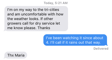
Here’s my early morning text exchange with a client. I really think they like getting a response within seconds when they contact me at odd hours.

So did the text I got from a client who had to leave town to manage picking at another orchard he owns 2 hours away. (Coincidentally, this is the same grower who told me I might have saved his crop a few years back.) Without someone there to check how wet his trees might get in a rain event, he was depending on adjacent growers’ decisions to launch pilots to launch me. I only had one other orchard near him that was on contract, but it was close enough to be a good indicator.

Radar this Morning
The radar image for the Wenatchee area at 5:55 AM this morning.

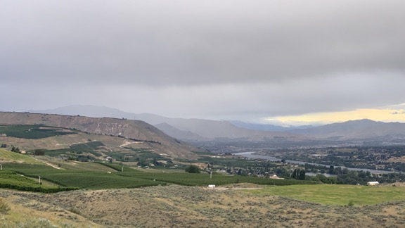
Around 6 AM, as I was having coffee, I was also watching the weather from my home. It’s perched up at the base of some cliffs, high up over the Wenatchee Valley and offers a 180° to 270° — depending on where you’re standing on my 10 acres — unobstructed view of the whole valley. It’s a perfect perch for someone doing what I do and makes a great base of operations for cherry drying services.

Here’s what I saw on radar and from my window.

Weather from my Deck
Here’s the view from my deck when I captured the radar image above.

I started texting my crew. Of the three guys, Trevor responded within a minute. He gets it, I reminded myself. The other two: nothing.

Then I got a text from my friend Cyndi, who lives up on Wenatchee Heights. (Cyndi’s house was my starting point in this recent video: Flying Home from Taco Night.) “It’s raining!” She said. (It’s funny how many of my friends report rain to me throughout cherry season. I definitely appreciate it.)

I put Trevor on alert but didn’t send him to his helicopter yet. I tried to get the other one in the area, Ben, on the phone. I called once and it went to voicemail. I told him that if he had Do Not Disturb turned on, he should turn it off. Then I called again. It went to voicemail again and I told him that he was in trouble. Then I texted his boss, who was in Portland. Ironically, he responded immediately. I made sure he understood that I wasn’t happy about not being able to reach the pilot I was paying him to be able to reach 24/7. On call meant on call.

Watch My Helicopter Videos on YouTube

Time for a shameless plug…

Flying M Air Logo

If you like helicopters, you’ll love the FlyingMAir YouTube Channel. Check it out for everything from time-lapse annual inspections to cockpit POV autorotation practice to a flight home from a taco dinner at a friend’s house — and more.

The rain moved through the area southeast bound. I texted two of my clients to see how much rain they had. One texted back that the rain had been light but it was very windy. The other called with the same information. Cyndi reported the same thing. It looked like we could stand down. I texted Trevor.

It rained at my house. The wind was howling so hard that only half of my deck showed drops and they dried within seconds of hitting the ground. Then it was gone and only the wind remained.

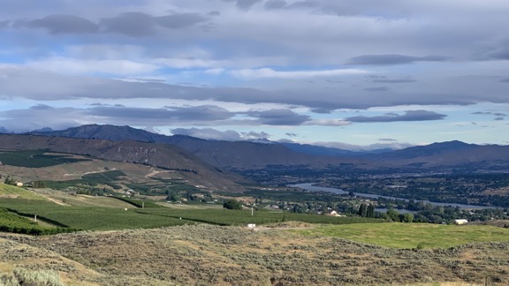
It’s an hour after I took the photo shown above. The sun is out and there’s some blue sky. Radar shows a “wintery mix” over Mission Ridge, which is south of the orchards we have on contract. Even if we did have some more rain, I’m pretty sure this wind — which has been in the forecast for the past few days — would dry the trees.

Clearing Weather
It’s an hour later and the weather is clearing out.

This is what I do for 10 weeks every summer: play the weather game.

Snowbirding 2019 Postcards: Superstition Mountains

I’m still in Arizona and still in my camper and still pulling my little cargo trailer. I signed up to display and sell my jewelry at an art show in Apache Junction this Saturday (tomorrow). I needed a place nearby to hunker down through the winter storm that was expected. Although a friend in nearby Mesa invited me to stay at her house, her husband has a terrible cold (again; what’s with that, Jan?) and I thought it best to stay clear.

I wound up just outside of the National Forest land north of Apache Junction, less than 5 miles from the Superstition Mountains. I found a relatively level spot alongside a wide dirt area, dropped the camper’s rear legs to level and stabilize it while still on the truck bed, and settled in for a three night stay.

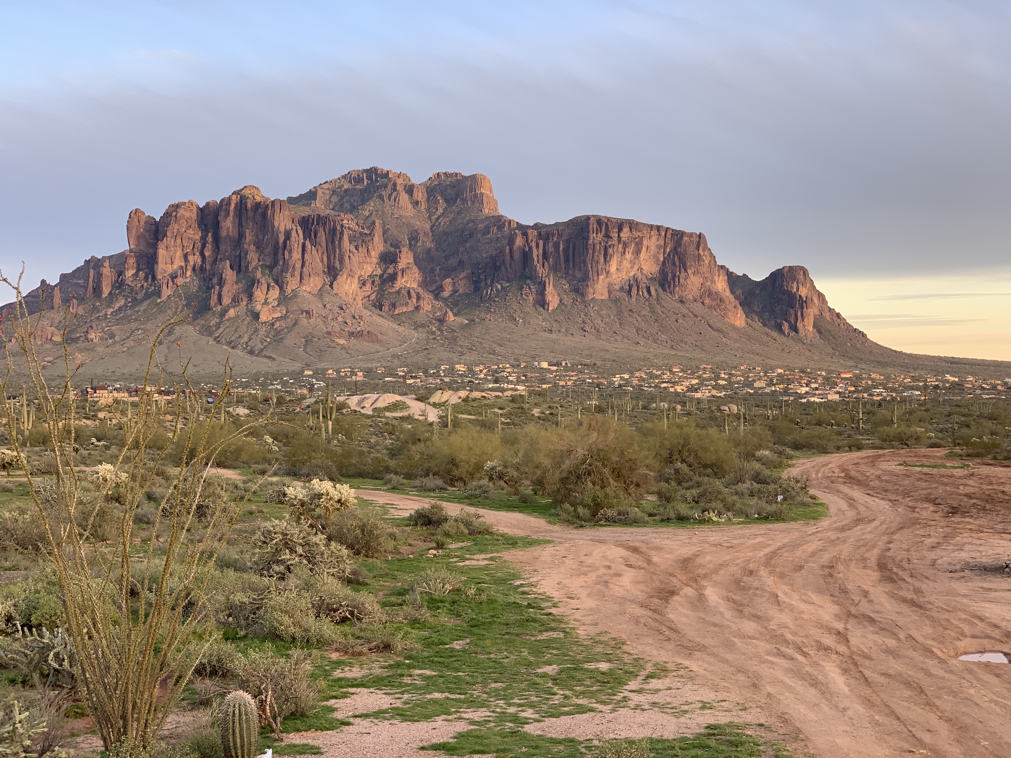
The Superstition Mountains were right out my dining area window. They glowed in Wednesday’s late afternoon light.

Superstition Mountains.

The Superstition Mountains in last light.

The expected winter storm came in right on schedule with scattered rain showers starting during the night and then turning to a steady rain just afternoon on Thursday. I had planned ahead and had everything I needed to work on a big jewelry project inside the camper. I listened to a recorded book while I started work on a fine silver chain for a customer. I even did a little live tweeting with photos.

The rain continued throughout the rest of the day and into the night, turning the dirt area near me and the dirt road I’d taken to get to my campsite into thick mud and reddish brown flowing puddles. The mudders came by in their trucks at 5 PM and some of them were still playing in the mud when I went to sleep at 9.

In the morning, it was still raining, but lighter. And when I looked out the window, I saw the Superstition Mountains blanketed with snow.

Superstition Mountains with snow.

The Superstition Mountains blanketed with snow the morning after a winter storm.

For those of you who aren’t familiar with the Phoenix area, this is not normal. I consider myself lucky to have the chance to see it.

The rain is starting to let up now, but I’ll spend the rest of the day here, finishing up that jewelry project and making a few pairs of earrings I need for tomorrow’s show. With luck, I’ll be able to get out of here tomorrow morning at 7 to set up for that show; I admit to having doubts, mostly because of the condition of the road. I’m sure the mudders will be back in force today; maybe I’ll get some video of their antics.

And, with luck, I’ll get another afternoon shot of the Superstitions in last light, perhaps with some lingering snow.

Last Flights of the Season

Santa drop-off, burgers with friends, and the special apple delivery.

I don’t care what the calendar says — winter is definitely upon the Wenatchee Valley where I live. After an early snowfall not long after Halloween and a subsequent thaw, the typical winter weather moved in, with four days out of seven filling the valley with fog. Sometimes my home, which sits about 800 feet above the river, was under it, other times it was in it, and a few times it was above it. The temperature hovered between 25 and 35 degrees day and night, so it wasn’t that cold. But it could be dreary, which is bad medicine for a sun-lover like me. I honestly don’t understand how people can live on the west side of the Cascades where it’s gloomy far more often than sunny all year around.

I normally go south for the winter and this year is no different. But I had some business to take care of at home, including my annual Santa flight, and couldn’t get back to the sun until after that. Scheduled for December 4, I fully expected it to be my last flight of the year. But sometimes I get lucky. Here’s a quick rundown of the three flights I finished the season with.

The Santa Flight

Pybus Public Market is a venue on the waterfront near downtown Wenatchee, WA. Once a steel mill, it was completely renovated about five years ago and now houses several restaurants and shops and hosts indoor and outdoor merchants for seasonal farmers markets and other events. It’s a really great public space, and a destination for locals and tourists, with plenty of events and things to do and see. Anyone who visits Wenatchee and doesn’t stop by Pybus is really missing something special.

Me and Santa
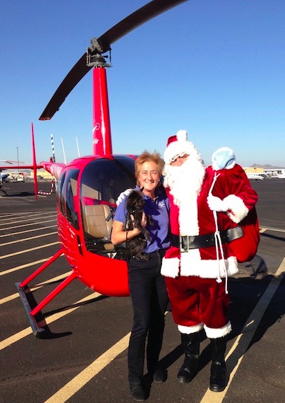
Here I am with Santa in 2012. Penny came along on the flight — she loves to fly in the helicopter. Note the polo shirt I’m wearing. Even with Santa’s door off, I wasn’t cold in December in Phoenix.

When I lived in Arizona, I was one of several helicopter owners/operators who volunteered to fly Santa in to the Deer Valley Airport restaurant in north Phoenix. The restaurant — which I highly recommend if you’re in the area; get the gyro sandwich — was privately owned by a Greek family and one of their sons would don a Santa suit on Saturdays and Sundays. For the four weekends leading up to Christmas, he’d get flown in by one of the local helicopter operators where a crowd of parents and children waited and cheered his arrival. We’d take turns picking Santa up at one of the FBOs at the airport, flying him north out of the airspace, and then turning around and returning — so it looked like we were flying in from the North Pole — and landing in front of the crowd. Once inside, Santa would sit on a big chair and kids would sit on his lap and tell him what they wanted for Christmas while parent cameras snapped. Then, I assume, the whole family would stick around for lunch. I blogged about the first time I did this, back in 2011; my wasband came along and took photos and you can see them in the blog post.

N630ML at Pybus Market
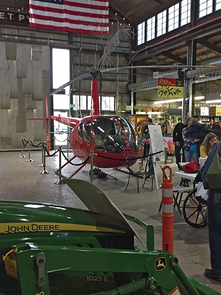
My helicopter is parked on display inside Pybus Public Market back in 2014. You can read the blog post about that here.

So when I moved to the Wenatchee area and fell in love with Pybus, it made sense to offer up the helicopter for Santa’s big arrival the weekend after Thanksgiving. Usually, Santa arrived in a fire truck, but most people agreed a helicopter would be way more exciting. I worked with Steve, the manager there, and set up a safe landing zone — or “heliport,” if you go by the definition that the county illogically clings to (long idiotic story there) — at the south end of the building. I picked up Santa at the airport and flew him in while a small crowd looked on. That was in 2013, the year I bought property for my new home in Malaga.

In subsequent years, Santa and I repeated the performance with bigger crowds every year. Weather was usually a factor though, and I remember one year waiting until the last possible minute to decide whether the flight was a go or no-go. But we made it each year and, when the weather was bad, I departed as soon as the crowd was inside the building so I could get the helicopter put away before the weather closed in again.

In 2016 — last year — the helicopter was in Arizona for its mandatory overhaul so I couldn’t do the flight. There is another red helicopter based in Wenatchee, however, and I knew the owner. I asked him to do it and he was game. But the weather did not cooperate at all and he couldn’t make the flight. Santa arrived on a fire truck that year.

This year, however, the helicopter was back in Washington and ready to go. I watched the weather all week and found it hard to believe the forecast for Sunday was as good as it was. On Friday morning, I went with Steve to the local radio station and talked up the upcoming flight. Steve said some really nice things about me and the other person who’d come along for the radio spot. Afterwards, I suggested that if the weather was good, Steve and I would go down to Blustery’s in Vantage for lunch. Bring a friend or two, I suggested. I was in no hurry to put the helicopter away if the weather was going to be good.

When Sunday arrived, the weather was perfect for a flight: clear, no fog, light wind. I picked up Santa at Wenatchee Airport and we touched down in the parking area — “heliport”? — there right on time. Here’s a video of my arrival on the Wenatchee World’s Facebook page.

Santa's Arrival by Helicopter at Pybus
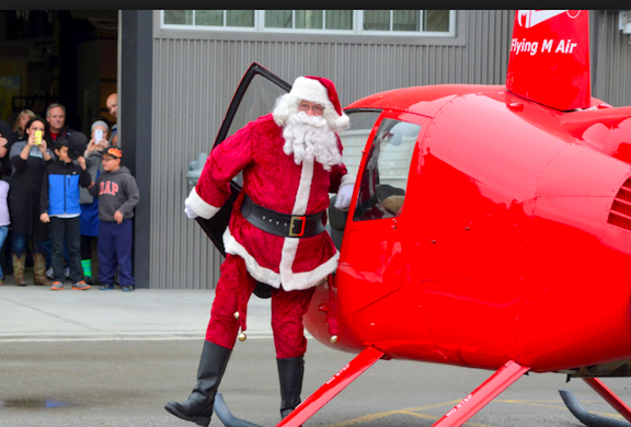
Here’s Santa stepping out of the helicopter at Pybus. I have a sneaking suspicion this Pybus website photo is from the 2015 flight because I don’t remember anyone being in the doorway when I arrived this year.

After Santa and most of the crowd went inside, I shut down the engine so a few of the onlookers could come closer to the helicopter. I gave the kids postcards that featured an air-to-air photo of the helicopter over a lake that could be along the Columbia River. Kids got their photos taken with the helicopter. I answered the usual questions about speed and fuel burn and how long it takes to become a pilot.

Onlookers Checking Out the Helicopter
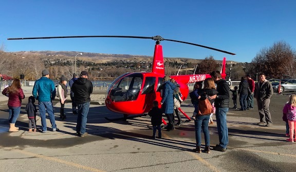
The helicopter at Pybus Public Market after last Sunday’s Santa flight. I like to give kids a chance to see the helicopter up close.

Will Fly for Food

Once the crowd around the helicopter broke up a little, we cleared the landing zone and Steve and a friend climbed on board. I started up and, a few moments later, took off over the river.

I cannot stress enough how perfect the weather was for flying. The cool air and recent engine overhaul worked together to give me amazing performance; cruising at 110 knots was easy. With very little wind, the flight was smooth and I could easily steer the helicopter anywhere I wanted to go. It was my first day flying in over six weeks and it really reminded me why I’d gotten “addicted” to flying and why I loved it so much. I felt as if I could have flown all day, stopping only when I needed fuel, and exploring every bit of the area that I loved.

We flew downriver over the two bridges and along the shoreline. I detoured to the south a bit to fly past my home, which Steve had never seen. Then we got back over the river and continued down toward our destination, about 30 miles (as the crow flies) away. It was nice flying with friends again — I haven’t been doing as many pleasure flights as I like these days — and seeing familiar terrain through their eyes. We saw the fire damage from the two early summer fires, one of which had come frighteningly close to where I live, new orchards and vineyards going in near Spanish Castle, and rock formations along the river. I dropped down low for a better look at the two huge herds of elk on West Bar, then flew up the Ancient Lakes side of Potholes Coulee and down the Dusty Lakes side. We went “backstage” at the Gorge Amphitheater, which was buttoned down for the winter, and past the Inn and yurts at Cave B Estate Winery. I flew past the rock climbers at Frenchman’s Coulee and pointed out the sand dunes near there that are virtually unknown to the folks in the area because they can’t be seen from any road.

Around then is when the wind picked up a little bit, adding some mild turbulence to the flight that made Steve a little nervous — unless he was just kidding? As I descended toward Vantage, I could see some whitecaps on the water surface below us. I crossed over the top of the I-90 bridge and made a right descending turn to my usual parking spot — or “heliport”? — at Blustery’s, crossing over the freeway just 100 feet up. As I set down — rather sloppily in a strong crosswind — I wondered if it was open because there was only one car there. But as I cooled down the engine for shutdown, we saw the OPEN sign. A few minutes later, we were inside, placing our orders.

Steve and Annette at Blustery's
Steve and his friend Annette with the helicopter at Blustery’s in Vantage, WA.

The folks who work in Blustery’s know me and always seem glad to see me. I know they know the helicopter is out there in the parking lot when I come, but none of them have ever said a word about it. One of these days, I’m going to take them up for a quick ride.

I ate my favorite three-meals-in-one-burger: the Logger Burger. It has two burger patties, bacon, ham, cheese, and a a fried egg. It’s huge and very tasty. And messy. I didn’t think I could finish it all, but I did. I pretty much skipped the fries. Steve picked up the tab, of course. That’s one of my rules: when I fly you for a meal on my dime, I fully expect you to pick up the tab for that meal. Folks who don’t get that, don’t get a second flight.

It was about 3 PM when we headed out on the return flight. The wind down there was still blowing pretty hard — it’s almost always windy on the river there — but I pointed the helicopter into the wind and let it help us climb out. I flew along the cliff face on the west side of the river, looking for the bighorn sheep I knew might be there. When I spotted one, I made a 360° turn to loop around and make sure my passengers could see it. It turned out that there were two of them, running off to the west with their white butts making them easy to see among the golden grass and sagebrush. We continued onward over the tops of the cliffs there, looking for more wildlife but coming up empty. This time of year, the elk move to lower elevations along the river, which is why we’d seen so many at West Bar, across the river from Crescent Bar. We descended closer to the river near the old Alcoa aluminum plant, where I made my radio call for landing at the airport. A short while later, we were on the ground.

I put the helicopter away, thinking it was the last time I’d fly it for the year.

The Apple Express

I was toiling over my to-do list at 7:30 AM on Tuesday when my phone rang. It was the helicopter pilot for one of my clients. I’d done such a good job flying them around a few years back that they’d decided they needed their own helicopter and had bought one. Tyson, a vet who’d learned to fly in the Army, had been hired to fly it and we’d become friends. I still flew for them occasionally, but not as often as I’d like to. They’re really nice folks and I always learn a lot about agriculture when we fly together.

Tyson’s helicopter was in pieces in Hillsboro, OR, for some scheduled maintenance. Normally, that was fine — his employers rarely flew in the colder months. But this morning, they had an emergency. They had to get 240 pounds of apples to a packing plant in Pasco, WA and had a tight deadline. Making the 2-1/2 hour drive was not going to get them there on time. They wanted to fly them. Could I take them on my helicopter?

After a miserable Monday, that day’s weather was perfect. There was some patchy fog low over the river here and there, but a quick check of the weather along my flight path showed it was good to go. So I said yes, got dressed, and hustled to get the helicopter ready for departure.

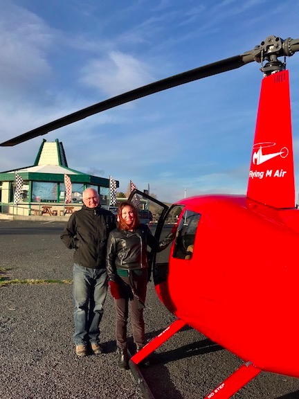
Tyson came with me, mostly because he knew the landing zone — “heliport”? — better than I did. We left Wenatchee Airport together and landed at the landing zone his employer had set up behind their facility in Wenatchee. On our descent, we spotted a bald eagle perched on a pole beside an empty osprey nest.

Apples in Helicopter
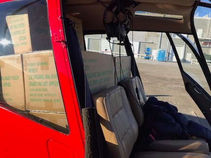
The boxes of apples filled the back seat area of the helicopter.

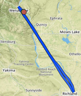
The apples were in 20-pound boxes and they absolutely filled the back seat area of the helicopter. Honestly, I didn’t think they’d all fit. But we got them in, closed the doors, strapped ourselves back in, and headed southeast on a direct course for the packing plant northwest of Pasco Airport, 86 nautical miles away. That meant an immediate climb to clear the cliffs just south of my home. I hadn’t flown that way in a long time; I prefer following the river whenever I can, but when a client is paying for flight time, you go direct whenever possible.

Just beyond the ridge, the valley was filled with low clouds. I maintained altitude as we flew over them, crossed the river again, and cut across the Quincy basin. The clouds disappeared. The air was calm and the flight was smooth. Tyson and I chatted about all kinds of things. It was nice to have company on the flight. We crossed Saddle Mountain and I maintained altitude to cross the Hanford Reserve, which has been in the news too much lately. The chart requests that pilots maintain 1800 feet MSL over that area and I’m all for that, especially since our flight path took us pretty darn close to the nuclear power plant at the south end of the reserve. The clouds were over the river there again and visibility at nearby Richland Airport was down to 1 mile. I exited the reserve area and started my descent, flying over those clouds.

I called in to Tri-Cities Airport for permission to land. Even though we weren’t landing at the airport, our landing zone was within Tri-Cities’ airspace so communication with the tower was required to enter the space. We saw the facility when were were still a few miles out and Tyson guided me to the landing zone on the southwest side, a gravel parking area. I flew low over some wires and set down smoothly in the middle of the area.

I was expecting someone to come out and receive the boxes, but no one appeared. So Tyson and I offloaded them ourselves, setting them out in a row on the gravel so my downwash on departure wouldn’t knock over a stack. Tyson walked off toward the building and found someone to talk to about the boxes while I took a few photos and secured the back doors. Then he climbed back on board and we departed to the northwest, after chatting with the Tri-Cities tower controller again.

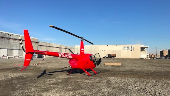
Helicopter and Delivered Apples
Before departing, I took a photo of the helicopter in its landing zone with the apples we delivered. I have a lot of photos of my helicopter in various unusual landing zones. (Or do I mean “heliports”? I’ll have to ask the folks at the Chelan County building department, since they apparently know more about helicopters than I do .)

Track Log
Our track log for the apple delivery flight. I use Foreflight to automatically track the exact path of all of my flights these days.

We returned by almost the same exact route, although I did pass on the west side of the nuclear power plant on my way back. By then, just about all of the low clouds had cleared. It was still calm and smooth. I flew much higher than I usually did, even after leaving the Hanford area, and was treated to unobstructed views of Mount Rainier and Mount Adams. The only other interesting thing we noted on the way back was a C-130 transport flying below our altitude on a practice run for a drop zone east of our flight path. Tyson knew the frequency they’d be talking on and we tuned in. Soon, we heard air traffic control notify the huge plane about traffic 10 miles west at 3300 feet northwest bound — us. Tyson and I kept an eye on it until we were well clear of the area.

I crossed the ridge behind my house again and started the steep descent to the airport. When I set down, I had mixed feelings. I was sad that this would definitely be my last flight of the year — I had meetings on Wednesday and was leaving town on Thursday — but happy that I’d gotten this unexpected flight on such a great day for flying.