Early Morning Helicopter Flight: Wenatchee, WA to Hillsboro, OR

There are some things you really wish you could share.

The panic started on Friday. That’s when I checked my helicopter’s log books and realized that instead of 14 flight hours until a required 100-hour maintenance, I had under 5 hours. Once that 5 hours expired, if I flew for hire — even for cherry drying flights conducted under FAR Part 91 — I risked the possibility of having my Part 135 certificate put on hold (or worse) and losing insurance coverage for my helicopter due to my failure to follow the manufacturer’s maintenance schedule.

I did not want that to happen.

I started working the phones. First, I asked my mechanic to come up from Phoenix. I got a “maybe,” which really wasn’t good enough. I talked to a number of other operators about using their mechanics but kept running into a problem with the required drug testing program. Finally, I called the folks at Hillsboro Aviation — which happens to be the dealer that sold me my helicopter back in 2005 — and talked to John. He said that if I could get it in to him when they opened at 8 AM on Tuesday morning, there was a chance that they could have it ready by day’s end.

The weather, of course, was of vital importance. I was in Wenatchee for cherry drying season; if there was any possibility of rain, I could not leave. I did have two other pilots on duty to cover my contracts, though, so unless it rained everywhere at once, they could handle it. And fortunately, the forecast had 0% chance of rain for the upcoming week.

I packed a light bag on Monday night: some spare clothes and toiletries (in case an overnight stay was required), dog food and a dish for Penny the Tiny Dog, and my log books. And on Tuesday morning, at 5:30 AM, I preflighted, packed up the helicopter, set up the GoPro Hero 2 “nosecam,” secured Penny in the front passenger seat so she couldn’t get into the controls, started up, and took off.

Foreflight Route
My direct route, on Foreflight.

My goal was to complete the flight as quickly as possible — that meant a direct route across the Cascade Mountains. My flight path would take me over Mission Ridge, across I-90 west of Ellensburg, and into the Cascades south of Mt. Rainier and north of Mt. Adams. Along the way I’d have to climb to just over 7,000 feet, fly over miles of remote wilderness area, and pass right by Mt. St. Helens. The whole flight was 159 nautical miles (183 statute miles) and would take just over 90 minutes.

I’d flown over the Cascades — or tried to — about a dozen times in the past five years. Weather had almost always been an issue. On several occasions, low clouds in the mountain passes at I-90, Route 2, or Route 12 made it impossible to get through. Other times, I had to do some serious scud-running, darting from one clear area to the next to find my way across. Still other times, I was forced to fly above a cloud layer until I found a “hole” in the clouds where I could slip back underneath on the other side of the mountains. I can only remember one time when scattered clouds were high enough to make the flight as pleasant as it should be.

The weird thing about the Cascades is that you can’t see what the cloud cover is like there until you’re airborne and have cleared the mountains south of Wenatchee. The clouds don’t show up on radar or weather reports unless it’s raining. So you might have a perfectly beautiful day in Washington’s Columbia River basin but the Cascade Mountains could be completely socked in with thick clouds. It’s actually like that more often than not — at least in my experience.

So despite the fact that it was a beautiful day, I was a bit concerned about the weather.

Until I passed over Mission Ridge, just south of Wenatchee. I immediately saw Mt. Rainier and Mt. Adams in the distance. Seeing these two mountains — the whole mountains, not just the tops poking up through clouds — was a very good sign.

Penny immediately curled up on her blanket on the front passenger seat and went to sleep. This really surprised me. It was the first time she’d been in a helicopter and she seemed completely unconcerned about it. I guess that was a good sign, too.

And so began one of the most beautiful flights I’d ever had the pleasure of doing in my helicopter.
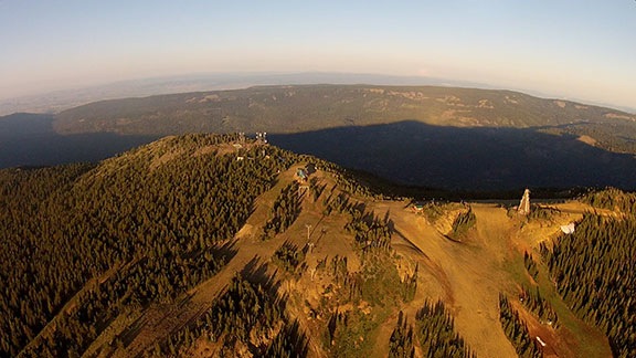
Mission Ridge
The top of Mission Ridge and beyond.

I crossed Mission Ridge, which was glowing almost orange in the first light of day and headed southwest along the straight line my GPS indicated to Hillsboro, OR. I drank in the scenery spread out before me: the windmill-studded valley around Ellensburg, the rolling pine forests cut with stream and river beds, the snowcapped granite ridges. At one point, I had Mt. Rainier off my right shoulder, Mt. Adams and Mt. Hood to my left, and Mt. St. Helens right in front of me. I felt like a tiny speck suspended in the air, the only person in the world able to see just what I was seeing. I felt small but all-seeing at the same time.

When I first caught sight of a fog-filled valley at the base of Mt. Rainier I began to realize that weather might still be an issue. Soon, I was flying from one pine-covered ridge to the next, over what looked like a sea of white foam. No VFR pilot likes to lose sight of the ground and I admit that I flew with some fear. An engine failure would leave me nowhere safe to land — if I tried to land in one of the valleys, I’d likely hit the ground before I saw it through the fog.

But the beauty of what was around me somehow made it okay. I thought to myself, if this is my time to go, what better place and way to end my life? Doing what I love — flying through amazing scenery — what else could anyone ask for? And then all the fear was gone and I was left once again to enjoy my surroundings.
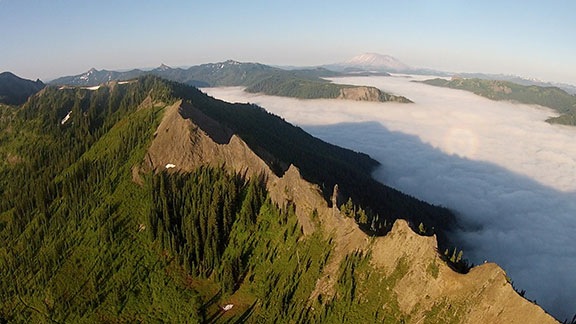
Cascades Ridge
Flying across this ridge was the highlight of my flight.

I also felt more than a bit of sadness. There’s no way I can describe the amazing beauty of the remote wilderness that was around me for more than half of that flight. And yet there I was, enjoying it alone, unable to share it with anyone. Although I think my soon-to-be ex-husband would have enjoyed the flight, he was not with me and never would be again. I felt a surge of loneliness that I’ve never felt before. It ached to experience such an incredible flight alone, unable to share it firsthand with someone else who might appreciate it as much as I did.

I can’t begin to say how glad I am that the GoPro was rigged up and running for the whole flight. At least I have some video to share.
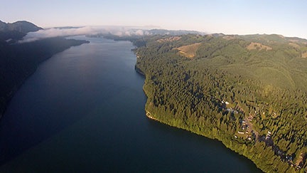
Mountain Lake
Yale Lake near Cougar, WA, just southeast of Mt. St. Helens.

As I descended down the southeast slope of Mt. St. Helens, leaving the Cascades behind me, I crossed over a small lake with a scattering of clouds at my level. As I glided through them and back into civilization, I felt as if the magical part of the flight was over. Indeed, the rest of the flight was rather routine, passing over rolling hills, farmland, highways, and rivers. A marine layer hung low over the Portland area and I squeezed under it, called the tower at Hillsboro Airport, and landed on the ramp at my destination. It was about 7:30 AM.
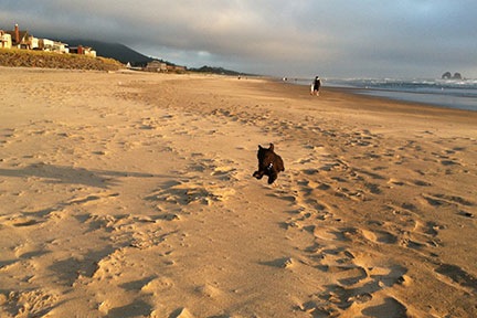
Penny at the Beach
Penny at the beach. She seems to like sand almost as much as grass.

The folks at Hillsboro Aviation were great. Although they didn’t finish up that day, the helicopter was ready to go at 9:30 AM the next morning. Penny and I had spent the night in Rockaway Beach, where Penny got to run through the sand and tease the other beach walkers with her antics.

We left Hillsboro at around 11 AM on Wednesday. It was a cloudless day — even the valley fog was gone. But the harsh midday light washed away much of the beauty of the scenery; the GoPro video from the return flight isn’t much to look at. We were back on the ground at our base in Wenatchee Heights before 1 PM, ready for another 100 hours of flight.

Sometimes, I REALLY Love My Job

I experience a “magic moment” in the course of doing my summer job.

A little backstory…

Cherry drying (or blowing) is one of those things most folks don’t know about. The short version is this: in the two to three weeks before the cherries are ready to harvest, if they get rained on they can split or rot, making them unmarketable. If a grower loses 50% or more of his crop to splits or other water damage, he won’t bother picking at all and the entire crop is lost.

So to protect the crop from this kind of damage, growers hire helicopter pilots with helicopters to stand by during the period before harvest. When it rains, they call us out to hover low over the trees. Our downwash blows the tree branches and shakes the water off the fruit, “drying” it. It’s tedious work that requires a good bit of concentration to deal with wind and obstructions. And it can be dangerous — in fact, there were three crashes in the area last year, one of which took a young guy’s life.

This is my fifth season doing this kind of work.

It was late afternoon on a day with drifting storm clouds. I was on call for cherry drying and had already gone out once, earlier in the day.

When I wasn’t flying or prepping the helicopter, I’d spent a good part of the day watching the weather radar on my iPad. Various colored blobs were drifting across from the west, after a gradual shift from their southwest to northeast direction earlier in the day. Rain varied in intensity from a light drizzle to torrential downpour. Every time a storm hit or missed an area, there would be another one right behind it to possibly do the same. Sometimes the rain was so intense that the storm would drain itself and the colored blob would fade as it tracked across the screen.

I was only on contract with one orchard: a 30-acre block of mostly very mature trees near the Columbia River. The grower was very careful about his orchard and, during the vital period, normally spent all day just about every day among his trees. Sometimes he’d mow the long strips of grass in the aisles between them. Other times he’d tinker with the tractors and other equipment he needed to care for his crop. Still other times, he worked on his shop, patching insulation, repairing a roof, adding a wall. Smart phones and good cell service — not to mention a good pair of eyes — had made it relatively easy for him to track the weather throughout the day. But he occasionally called or texted me at my base seven air miles away, where I had a better look at the sky and a bigger screen to watch the radar blobs.

I saw the storm coming on radar and confirmed it with a look outside. It was across the river to the west, heading right for the orchard. While there was a chance it might rain itself out before it arrived, I suspected it might not. Already still suited up from my flight a few hours before, I headed back to the helicopter to pull off the blade tie downs and prepare to fly.

Low CloudsThe sky was intensely dark out toward the river and the storm was definitely heading in my direction. But what was even scarier was the low hanging cloud near me that seemed to be swirling gently like something from a Weather Channel tornado special. I watched it for a while, wondering whether the storm was really intense enough to get a tornado going. It didn’t seem to be.

My phone rang. It was my client. “Work your magic,” he said.

It took me a second to comprehend his words. “It didn’t even start raining here,” I said.

“It poured like hell on the orchard,” he told me. “It’s stopped now. Come on out and dry.”

I hung up and moved my truck out of the way. By the time I was hurrying back to the helicopter, big raindrops were falling on me. The swirling cloud was gone.

I started up and began the warm up process. It wasn’t until I was pulling on my helmet that I realized I’d forgotten to take my door off. This could be a problem if the sun came out and it warmed up; the helicopter would become like an oven every time I faced the sun. But the sky was dark and that didn’t seem likely. Ah, little did I know…

By the time I lifted off the pad, the rain was dumping on me. The cockpit bubble was wet with a million drops. I pushed the cyclic forward and accelerated into my climb. The drops ran off the sides, clearing the window enough to see. I turned to the west and flew right into a wall of hard rain.

When I flew at the Grand Canyon back in 2004, we had a sort of mantra for dealing with heavy rain: if you can see through it, you can fly through it. This rain was so intense that I could barely see brightness in the sky beyond it. I was flying at about 200 feet off the ground — just high enough to clear the local power lines but probably not high enough to clear the high-tension power lines I knew were up ahead. The air was remarkably calm, so at least I didn’t have to deal with turbulence. I climbed cautiously, heading west, flying at 110 knots, focused on reaching the orchard quickly.

The sky brightened. The rain lessened. Then I was through the storm, on the other side, flying into what looked like a beautiful day.

A really beautiful day.

Ahead of me, the sun was shining brightly, sending patches of light through broken clouds onto the yellow-green hillsides beyond the Columbia River. Some low-level clouds were floating at my altitude over the river and beyond. Wisps of clouds were wrapping themselves around hilltops like winter scarves around thick necks. The sky had a kind of three-dimensionality I rarely get to see.

And over my right shoulder, back in the dark storm I was passing, was a double rainbow.

There are times that I can only classify as magical — times I wish I could bottle up and save, just so I can open them up to re-experience them when I need a little magic in my life. This was one of those times.

I realized, in a flash of clarity, that I really loved doing what I do.

I call myself a writer, but in all honesty, there’s no way I can express, in words, the feeling I get when I experience one of these moments. I can try to describe what I see. I can try to paint a picture for my reader to see something similar in his own mind as he reads my words. But in truth, there’s no way to share this kind of experience after the fact. It’s a moment in time and space — something that becomes part of me. It’s like a happy little secret I’m forced to bear, unable to share it with anyone else.

It’s moments like these that make my life worth living.

I cleared the big wires, reached the edge of the plateau, and lowered the collective almost to the floor to start a steep descent down to the river. The water was smooth, reflecting the clouds in a magnificent sky. Everything below me looked fresh and clean and wet. I descended at 1200 feet per minute over the river, then pulled the cyclic back gently to slow my airspeed and descent rate. Coming in over the orchardI came in over the orchard in a grand, swooping arc, settling in at the southeast corner in a hover over trees nearly as old as I am.

And then I got down to work, hovering back and forth, up and down the rows of trees, performing the tedious task I was paid to do.

From my seat only a few feet above the treetops, I could clearly see the bright red fruit and the droplets of water clinging to them. I could see my downwash shaking the tree branches all around me. Everything was very wet, but with only one pass, most of that water was shaken and blown down to the ground.

Sunset Cherry Dry

Golden Light

I stole glimpses of the river and sky and cliffs. It was early evening on a Washington day when the sun would set well after 8:30 PM. The sun played peek-a-book with thin strips of clouds. The sunlight illuminated the cliff faces in a golden light.

On the ground out on the road in front of the orchard, my client stood outside his truck, snapping photos with his camera. Inside the front passenger seat, I saw his mom. She waved once but, with both hands fully occupied, I couldn’t wave back. Later, the truck was in the orchard, near the shop building. The photos started arriving on my cell phone, which was docked in a cradle within reach, a while later. I wouldn’t be able to see them until much later.

It took over an hour to do the whole orchard. It always does. It’s a tough dry, with trees of varying ages and heights, a gentle slope, a deep gully, and some nasty wires right at rotor height along one side of the orchard. I spend a lot of time flying sideways so I can keep low on a downhill stretch without getting my tail rotor in the trees behind me. But finally I was done. I did what I think of as my “victory lap,” a fast, low-level flight diagonally across the orchard, gaining speed before pulling the cyclic back to start a steep climb up the cliff face.

At the top of the cliff, thin clouds were thickening, forming a fog layer that would soon be too thick to pass through. I squeezed through a gap in the clouds and pointed the helicopter east, toward my home base.


Note: Many thanks to Patrick, my client, for providing the in-flight photos that appear in this post and on Facebook.

Snow-Covered Mountains

Late winter storm leaves Weaver Mountains blanketed with snow.

Just thought I’d share a quick photo taken from the upstairs window at my house in Wickenburg. After two days of rain and snow throughout Arizona, the Weaver Mountains about ten miles north of here are completely blanketed with snow. I hope things aren’t too mushy for the folks in Yarnell!

Snow-Covered Mountains

Weather Forecasting: A Bad Joke?

Each “source” of weather tells a different story.

My work this summer is highly dependent on weather. Simply stated, if the weather is picture perfect and there’s no chance of rain, I pretty much have the day off to do what I like. But if there’s any chance of rain, I need to stick around my base just in case rain starts. And if it’s raining, I go to work.

So, as I mentioned elsewhere on this blog, I’m really in tune with the weather.

Or at least I try to be.

The trouble is, I track the weather using multiple sources on my computer, iPhone, and iPad. And it’s very seldom that they all agree.

Today is a perfect example. Here are screenshots for the various sources, all captured within the save 5-minute period. What interests me is what it says for Sunday, Monday, and Tuesday.

National Weather Service

The National Weather Service website is my preferred source of weather data. It’s a no-frills site that doesn’t have very good weather graphics — radar, etc. — but does have well-described weather forecast data.

National Weather Service Forecast

Note that in this forecast, they’re showing a 20% chance of rain on Monday.

The Weather Channel

Everyone loves the Weather Channel website. I don’t. It’s full of ads and info that most people who are serious about weather forecasts has no interest in. But it is a source of weather info and I do occasionally consult it — usually for radar graphics.

The Weather Channel Forecast

Note that this forecast indicates a 20% chance of rain on Sunday and only 10% on Monday.

Intellicast

Intellicast is the pessimist of weather forecasting. I’ve discovered that if any forecast shows a chance of rain, it’ll be Intellicast. I use the Intellicast app on my iPad, but there’s also an ad-heavy website.

Intellicast Forecast

In this case, Intellicast matches the Weather Channel’s forecast regarding rain: 20% Sunday and 10% Monday.

WeatherBug

WeatherBug ForecastI use Weather Bug on my iPad and WeatherBug Elite on my iPhone. They usually have the same forecast.

This screenshot is from the iPad version. It’s showing a 20% chance of rain on Monday, just like the National Weather Service. As you might imagine, the iPhone version shows the same information (although in a different way).

Which One is Right?

In this example, at least there is some agreement between the different programs. The way I read this is that rain is possible sometime on either Sunday or Monday or both. Chances are slim but is possible — at least as of now.

Of course, I’ll watch all of these sources throughout today and tomorrow to see how they change. These forecasts will change. They were, after all, different yesterday.

Will they ever all agree? No. I’ve experienced rain when the forecast for one said no rain and another said there was a 10% chance.

Monday, July 25, was a good example. I went to bed on Sunday after seeing a 10% to 20% chance of isolated thunderstorms for Monday, yet was awakened at 4:30 AM on Monday by a pouring rain that didn’t really let up until 2 PM that afternoon. All the pilots flew all day that day; it was a nightmarish situation where all the orchards got wet and needed service. (I also got calls from orchard owners who weren’t under contract with me, begging me to come. I couldn’t — I service my clients first and it took all day to take care of them. A lot of cherries were lost that day.)

So I’ll be watching the weather closely for the next few days, never wandering far from base.

Who knows? Maybe tomorrow raindrops on my rooftop will put me on active standby before my morning coffee.

Phoenix Dust Storm Time-Lapse

Excellent footage of a desert phenomenon.

No, this isn’t one of mine. But it offers two excellent views of a larger-than-usual dust storm bearing down on Phoenix, AZ.

These storms are nasty. Although they can occur a few times during early “monsoon” season, they’re not usually as big as this one.

[Edit Note: The original title of this post referred to this as a “sandstorm,” although it was properly identified as a “dust storm” within the post. I’ve since fixed the title.]