One of the growers I’m working for this year asked me if I’d add another 5-acre block to the list of cherry blocks I’m drying in June. The block in question was in Wenatchee. Not the outskirts of Wenatchee, like another block I’m doing for him. This one is in Wenatchee.
I got directions and drove out there yesterday. It wasn’t easy to find. That could be because it was in the middle of a suburban neighborhood. The cherry trees were surrounded by taller trees and houses. One of the cherry trees actually overhung the garage of a house on the border of the block’s property. I saw all this from the one street where I could see the trees from my truck. I didn’t see it from the air.
I wasn’t happy about the location. There were power lines and too many houses. I wondered whether the town had any ordinances that prohibited low-flying aircraft. After all, I’d have to fly just 5-10 feet above the trees. About equal with the rooflines or second-story windows of some of the adjoining houses.
I got back to my camper and called the Wenatchee police. A dispatcher took my info. An officer called me back about an hour later. I explained the situation.
“Are you definitely going to do this?” he asked.
“I don’t want to,” I admitted. “This is what’s going to happen. About half the people around there will think it’s really cool. The other half will call you or the FAA to complain. And if it rains overnight, I fly at dawn. That means 5 AM.”
“We have a noise ordinance,” he offered.
“That’s good,” I said.
“And what about safety? Aren’t you worried about crashing into houses?”
“I wouldn’t crash into houses if I go down,” I assured him. “But I would go into the trees. And things would fling off. It wouldn’t be pretty.”
“I don’t think you should do it,” he said.
“Works for me,” I replied.
We wished each other a pleasant evening and hung up.
This morning, I was in the area with my helicopter and another pilot on board. That’s when I got the full picture of the orchard and its odd shape. I asked the pilot with me to take some photos. So here’s the orchard I won’t dry:
I’m living in my camper on a golf course south of Quincy, WA. The golf course is in the middle of farmland. In fact, the golf course used to be a farm field. The irrigation circle (or semi-circle) is still used to water the fairways. Because of this, all of the trees in the middle of the course are very short.
It’s a weird setup.
Last year when I was here, I took walks with my camera quite often. (You can find some of my better photos in my Photo Gallery; click here for a slide show of my Washington shots.) I’m trying to get into the habit of doing that again. I walk along the edge of the golf course property. There’s a canal on the south side with rushing water. On the other side of the canal, there was a wheat field.
This year, it’s alfalfa.
I was surprised to see the change. The alfalfa was freshly cut — no more than a day or two ago. They cut in the shape of the irrigation circle (or semi-circle). It was difficult to get a good shot at the curves.
The alfalfa will be left to dry in the field for a week or so. Then they’ll drive through with a baler and gather it up into bales that are dropped on the field. Later, another piece of equipment will come by and gather up the bales. They’ll be transported somewhere and covered with tarps until sold or used.
Last year, I didn’t start walking around the golf course until late June or July. I suspect that they’ll plant wheat in the field when the alfalfa has been taken away. I’m not sure if it’s too late to plant that — other fields already have wheat crops that are quite tall.
But I’ll observe and learn and maybe report back here.
I’m in Quincy, WA, right now, living in my camper while I work four cherry drying contracts. I live in my camper because it’s cheaper than living in a motel. A lot cheaper. And since I can cook my own meals, I save a ton of money over the cost of a motel.
One of my contracts is for an orchard down by the Columbia River. There’s a campground literally across the street from it. The campground is also right on the river. I thought it might be nice to stay there for the duration.
I called. They wanted $42 per night for a hookup that included water and power, but no sewer. They weren’t interested in giving a discount for long-term stays. In fact, they didn’t seem to want long-term guests. I figured it was because they were so busy they didn’t need the business.
I knew I could camp at the Colockum Golf Course (formerly the Quincy Golf Course) for $300/month. The site included electricity, water, and sewer. High-speed, reliable WiFi was also available for an additional $35/month. There’s even a restaurant on the premises.
I couldn’t justify the additional $30+ per night for a campsite with fewer amenities. I parked at Quincy, where I’ll likely spend the next seven weeks.
Yesterday evening, I drove down to the orchard to refresh my memory about the setup. I needed to know where the powerlines were and whether there was a fan in the block. While I was down there, I drove through the $42/night campground.
Every single spot was empty.
So explain this to me: wouldn’t it be more beneficial to get someone in there for $20/night ($600/month) rather than no one in there for $42/night?
My helicopter is sitting in a hangar at Boeing Field in Seattle, WA, being tended to by a team of experienced Robinson helicopter mechanics. There’s nothing wrong with it — well, other than a few minor squawks. It’s in for its annual inspection.
I, on the other hand, am in Wickenburg, AZ, finishing up some work before I head northwest for the summer.
So, for a while, I’m helicopterless.
Of course, now my phone is ringing with calls from folks who want to fly. Tours of Phoenix, day trips to the Grand Canyon, photo flights west of Sedona, and even a tour around Wickenburg (if you can believe that). Sorry folks. No can do. Helicopter is out-of-town and I’ll be joining it shortly.
We flew it up last week. I took Alaska Air back to Phoenix. Next weekend, I’ll hook up my travel trailer to my husband’s pickup truck and drive up to Quincy, WA. Although I might spend a few days in the campground on Crescent Bar, it’s more likely that I’ll simply return to the Quincy Golf Course and set up camp in one of its five full-hookup sites. The manager there is looking forward to my return — isn’t that nice?. He was pleased to tell me that they fixed last year’s Internet problems and now have WiFi on site. Sometime the second week in June, I’ll hop a flight on Horizon from Wenatchee to Seattle, hitch a ride to Boeing Field, and climb aboard my helicopter for the flight across the Cascades and back to Quincy.
I might even take one of my Twitter friends along for the ride.
But until then, I feel strangely grounded in Wickenburg, with nothing to fly.
It’s odd. I hardly flew at all in March and April, yet I didn’t miss the helicopter. After all, it was nearby, in its hangar. I flew quite a bit in May, covering it with dead bugs on that last flight into BFI. Now, with May drawing to a close and the helicopter 1000+ miles away, I miss it.
I’m already looking forward to that flight in June.
And hoping for a rainy cherry season in central Washington, so I get plenty of time to fly.
Cross-Country, Defined
For those of you who are not pilots, allow me to explain the term cross-country as used by a pilot. A cross-country flight is basically any long flight with a landing a certain minimum distance from your starting point. For airplane pilots, it’s at least 50 miles. For helicopter pilots, it’s at least 25 miles. So while this blog entry discusses a very long cross-country flight, we did not fly all the way across the country.
This past Thursday and Friday, I flew by helicopter with two other helicopter pilots, Ryan and Bryan, from Wickenburg, AZ to Boeing Field in Seattle. Bryan and Ryan did just about all of the flying. I sat up front being a nervous passenger when we were near the ground and playing with the radio and GPS. Brian let me make most of his radio calls on the first day, but I didn’t get to do much of that the second day.
It was a mutually beneficial journey. I needed to get the helicopter from Arizona to Washington State. Ryan and Bryan were both CFIs who wanted to build time in an R44 helicopter. It was way cheaper for them to fly with me on this trip than to rent an R44 from a flight school. There was also the added experience of planning and executing a flight through unknown terrain, with fuel stops and an overnight stop along the way. And the money they paid to fly my aircraft helped me cover the cost of this very long and very expensive helicopter flight. Win-win.
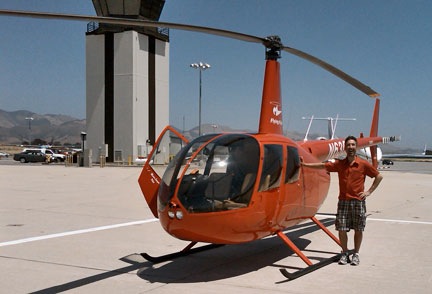
A very cool but very helicopter-unfriendly fuel island at Corona Airport in California.
Our flight path took us west, with Bryan at the controls, along state route 60 to I-10, across the Colorado River, and then along I-10 through Bythe, Chiriaco Summit, Palm Springs, and Banning; then back on 60 past March to Riverside on the 91. We stopped at Corona for fuel at what’s likely the coolest but most helicopter-unfriendly fuel island in the world. (We didn’t notice the separate fuel island more suitable for helicopters until we’d stopped and shut down.)
Here’s a video of our transition along the California coast through the LAX airspace on the Shoreline transition route. You might want to turn down the sound while playing it; lots of helicopter noise.
Then Ryan took us west on 91 through the airspace for Fullerton and Long Beach, with a Torrance low pass. (Robinson has entirely too many helicopters waiting for owners on its ramp and in its delivery room.) He then got clearance for the Shoreline helicopter transition of LAX space, which requires the pilot to drop to 150 feet 1/4 mile offshore to pass under LAX departing traffic. We continued following the coast up past Santa Monica, Pacific Palisades, Malibu, Oxnard, Ventura, and Santa Barbara. By then, the marine layer was moving in, so we went inland for a bit. Eventually, we reached San Luis Obispo (and the chatty controller) and stopped for fuel and lunch.
Here’s Ryan on the ramp at San Luis Obispo before departure northbound. I shot this one with my Blackberry’s camera, so pardon the quality.
Bryan was back at the controls for our departure northbound. After a very close call with a large bird, we followed the path of Route 101 northbound. Most of the route was up a riverbed in a very pleasant valley. We got to Salinas and realized that any coastal route would be out of the question — the marine layer was creeping in even there. So we headed over the mountains, eventually ending up in the western part of California’s Central Valley. We stopped for fuel at Byron.
Ryan took over and we continued north over Rio Vista and Yolo, finally hooking up with I-5. We followed that through endless farmland — much of it flooded for a crop that apparently needs lots of water — over Willows Glen and Red Bluff, with more than a few crop-dusters flying nearby at altitudes far below ours. We stopped for the night at Redding, tied down the helicopter, and got a hotel shuttle into town.
We’d flown 8.8 hours.
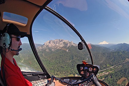
Ryan at the controls as we near Mt. Shasta in northern California.
The next morning, we were back at the airport at 9 AM, preflighting and getting ready to go. Ryan would start the flight. We headed north along I-5, over Lake Shasta and past Mount Shasta, which was snow-covered and beautiful. We were now past Central Valley’s vast farmland and up in the mountains. We flew past Weed, Siskiyou Co., Rogue Valley/Medford, and Grant’s Pass. Much of this flying was in canyons, along the same route as I-5 and a train line.
Things turned a bit iffy as I-5 swung to the east. We were hoping to go north and catch it on the other side of some mountains, shortening our route a bit, but clouds sitting on the tops of those mountains made that a bit uncertain. So we dropped altitude, slowed down, and followed I-5. Ryan flew while Bryan and I kept a sharp lookout for the power lines we knew — from both chart and GPS — were ahead. We weren’t that low and there wasn’t any real danger, but we were certainly not coming out of that canyon anywhere except the I-5 corridor. We passed the powerlines with plenty of room. The road descended into a valley and we stayed up beneath the cloud bottoms. Eventually, the sky cleared. We continued along I-5 past Myrtle Creek and Roseburg and stopped at Cottage Grove State for fuel and lunch.
Then it was Bryan’s turn again. We continued up I-5 past Hobby, Albany Municipal, and McNary. Then we headed northwest over Sportsman’s, Hillsboro, and Scappoose. We crossed the Columbia River and headed north on I-5 again over Kelso Longview and Olympia, with nice views of Mount St. Helens and Mount Rainier in the distance. Then on to Bremmerton, where we stopped for fuel. We probably had enough to make the last 20 minutes, but why take chances?
Zero-Mike-Lima on the ramp at BFI. Another Blackberry photo. And yes, that’s Mt. Rainier in the background.
I flew the last leg with Bryan up front to handle the radio and give me directions. It was only a 15-minute flight, but the airspace was complicated, so I was grateful for the help. I set the helicopter down sloppily in the parking area. We’d flown a total of 14.4 hours.
It was a great flight. We saw so much that most of it is just a blur in my mind. With luck, these photos and videos will help me remember the trip for a long time to come.
Many thanks to Ryan and Bryan for accompanying me on this trip. I hope they learned a lot about cross-country flying.