A motorcycle ride and a hike.
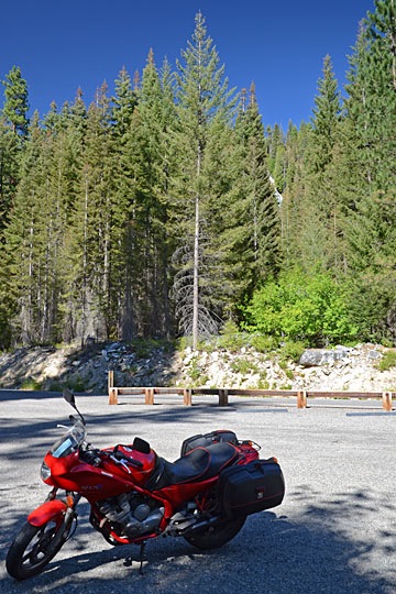
I had my 1992 Yamaha Seca II motorcycle shipped up to Washington State so I’d have something other than the pickup truck to ride around in while I’m here. Not only does it get about 50 mpg (compared with the trucks 15 or so mpg), but it’s a hell of a lot more fun to get around in.
When it first arrived, I discovered — without any real surprise — that my motorcycling skills were extremely rusty. I took it for a few short rides to get get the feel for it again. Then I took it to Chelan to visit a friend. And I’ve been riding it a few times a week since then.
But it was yesterday that the rust finally shook off.
Along Entiat Road
I decided that it was high time to take it out on some mildly challenging twisty roads. After consulting a map, I decided on Entiat Road (County Highway 19), which winds up the side of the Entiat River. The road is only about 38 miles long — or at least that’s what I gathered by the “Road Ends 38 miles” sign near where I picked up the road in Entiat on the Columbia River. I figured I’d ride it until either it or the pavement ended.
I left Wenatchee Heights at noon and, after winding my way through the city of Wenatchee and up route 97 toward Chelan, reached the turnoff for Entiat road at about 12:30. It was a typical two-lane road in good condition, smooth with no loose gravel. I was able to open up the bike and get some good practice leaning into the curves at speed. I drove past orchards snuggled into the valley — the apples and pears still hung, ripening, while the cherries had already been picked.
I was hungry — I hadn’t eaten before leaving — and figured I’d stop for lunch at the first place I found along the road. That first place happened to be about 10 miles up the road at Ardenvoir, a place called Cooper’s Store. It was also the last place; a sign nearby said “No services past this point.” It didn’t look very appealing, but I didn’t have a choice, so I parked the bike and pulled off all my gear: helmet, gloves, denim jacket. A sign outside said “Food voted five stars by Odee.” So, of course, when I went inside I asked who Odee was. Turned out to be the owner’s dog, an aged terrier that came up to sniff my hand when he heard his name.
I had a chili burger. In Arizona, that’s a burger with a green chili on it. At Cooper’s Store, it’s a burger under a heap of chili con carne with chopped onions and shredded cheese. To put a positive spin on it — it’s always nice to stay positive, no? — I can confirm that it was edible. I grabbed a popsicle out of the freezer in the store for dessert, paid up, and went outside. I sat on a bench out front to eat my popsicle. Three vehicles went by. A Jeep stopped at the store and the driver went inside while the passenger looked at me sitting on the bench. I guess there was nothing else to look at. Finished, I geared up and continued on my way.
The road continued up the river, sometimes quite close, past farms and homes and unlikely subdivisions that had never been sold. Many of the homes were for sale. Lots of waterfront property. A beautiful log house, brand new, with a “For Sale” sign on it. A real homesteaded property. An area that had obviously suffered a forest fire only a few years before — the weathered skeletons of burned trees were all that remained with tall grass on otherwise bare hills.
I have no idea how far up the road I was — 20 miles? 30? — when the pavement became rough and a sign informed me that I was entering the Wenatchee National Forest. No more homes along the side of the road. Now it was just tall pines along steep inclines with sharp curves in the bumpy road. I slowed down after being jarred violently going over a bump. A sign mentioned a place called Silver Falls 8 miles farther up and I figured that was as good a destination as any.
The Hike
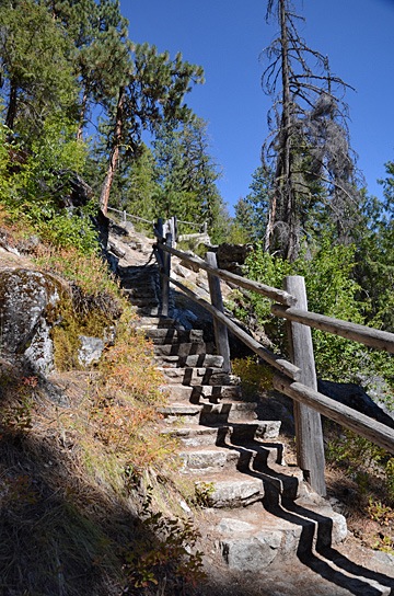
 There were National Forest Campgrounds along the side of the river. I passed two before I reached the parking area and campground for Silver Falls. I parked and stripped off my gear, locking it up in my bike’s Givi saddlebags. Looking up, I saw the top of the falls — can you see it in the photo? It didn’t seem that far away.
I checked the information kiosk. There was no information about the hike, although I could clearly see a trail disappearing into the forest across the road. I did see that there was a $5 day use fee. Although it was midweek and I thought I’d only be there a short while, I know how much the parks are struggling. So I filled out the form on an envelope, put a $5 bill in it, and tucked it into the payment slot. Then I grabbed my camera and started the hike.
 I immediately found myself in a deep, somewhat dark pine forest. As my eyes adjusted to the light, my nose picked up the scent of pine and moisture and my ears heard the sound of rushing water. I came upon the creek immediately — a healthy stream of water gushing over rocks between trees. For me — a desert dweller — it was a real treat.
The path was well-maintained, with rustic protective barriers to prevent hikers from accidentally falling into the stream. The bridges were especially rustic looking, sometimes with curved logs making attractive rails. It was surprising to find something so attractively designed on a trail. I began to wonder how much of the trail dated back to the CCC days, when National Forest trail projects were a source of employment during the Great Depression.
I followed the path as it climbed gently upstream, first on one side, then the other. The trail forked at a bridge where I stopped for a rest. A family of three was just coming down the right side of the creek. “It’s worth it,” the Dad assured me.
I continued up the way they’d come down. The trail began to climb. It moved away from the creek and then back to it, offering stunning views of the rushing water. The farther I went, the steeper the trail got. In many places, it was rock steps. I paused at another rest spot. The mist from the falls chilled the otherwise hot air. I could see the main falls above me. When another family joined me, I asked whether the trail went all the way to the top. The Dad told me it did. Remembering the other guy’s assurance, I continued the hike.
At one point, the trail came back to the creek just beneath a large fall. Although the rustic wooden logs made it clear where the trail stopped, I did as many others had likely done and slipped beneath the two rails. I was able to safely get to a spot beneath the waterfall, tucked under a rocky ledge. I experimented with my camera, trying hard to protect it from the mist, until mosquitos found me and I decided to move on.

After that point, the trail swung far from the stream — so far that I could no longer hear the water’s flow. It also leveled out. Perhaps I’d misunderstood the other hiker? Perhaps that spot under the falls was as high up as the trail would go? Perhaps it would continue back along the mountainside, away from the falls?
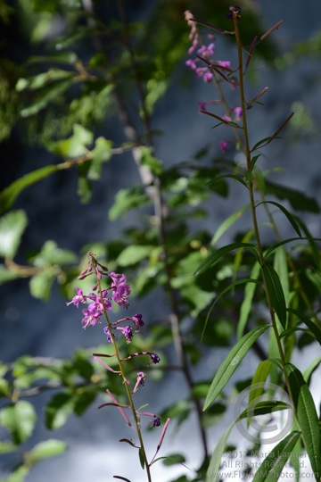
But I stuck with it and was rewarded with a switchback and another climb. A while later, I was back alongside the stream at yet another streamside bench, photographing some beautiful purple flowers just past the peak of bloom.
It was then that I noticed a similar rest area on the other side of the creek. The trail had split and, apparently, the other trail climbed up the other side. Would they meet again at the top, forming a loop? Could there possibly be another bridge? It was too much to hope for. I’d assumed I’d be returning the way I’d come. Now I was starting to wonder.
I continued on my way, up more stairs and another turn away from the creek. After another switchback, I returned to the creek and saw the bridge over a smaller falls. I spent a lot of time up there, relaxing in the shade, snapping photos of the water falling over the rocks. Again and again I wished I’d had a tripod or at least my monopod along with me — the shade was dark in the dense forest.
Then I started down the other side of the creek. At first, it was one long flight of stairs after another. Then the trail moved away from the falls in a series of relatively level paths with switchbacks. In some places, the trail emerged from the forest into the sun; not only could I feel the heat on my skin, but I could smell it. Then back into the trees for cooling shade and pine aromas.
At one point, the trail came back to the falls just below where I’d walked along the ledge on the other side. The mist and sun worked together to produce a small rainbow. I did the best I could to capture the scene with my camera; I really do need to learn how to photograph waterfalls properly.
A while later, I was back near place where the trail had split. I took my time following the trail back out to the main road. The parking lot was empty except for my motorcycle.
It was 4:30 PM. I’d been there for nearly 2 hours.
I’d gotten my $5 worth of nature — and more.
The Ride Back
Although the road continued farther up the river, I was tired and thirsty. I figured I’d save it for another day — perhaps a day when I could share it with someone. So I geared up and pulled out.
I did take time to check out the three campgrounds I passed on the way back. The first and third were partially occupied and had nice sites looking out over the Entiat River. I’m not sure, but I think I could get the mobile mansion into at least some of the spots if I wanted to. It would be tough, though. The second campground was deserted and I could understand why; the sites were small and unappealing. None of the campgrounds had utilities, although they all had centralized water spigots and outhouses. The single campground host was not around.
I rode more aggressively on the way back. I felt as if I’d regained a lot of the motorcycling skill I’d had back in the 90s when we rode all the time. It felt good to lean deeply into the curves and accelerate through them, especially when I was out of the National Forest and the road conditions were a little better.
I passed Cooper’s Store with only a momentary thought of stopping in. I do wish I’d taken a photo, though. The Odee sign was pretty funny.
The motorcycle started losing power about 5 miles from the end of the road. I was able to switch to the Reserve setting while moving and before the engine quit.
At the junction of Route 97, I turned left toward the town of Entiat. My first concern was fuel; I took 3.6 gallons. Then I pulled up to 97 Brew, one of Washington State’s ubiquitous drive-through coffee stands. I rode up on the shady side and after getting my smoothie, asked if it was okay to stay parked there in the shade until someone else pulled up. No problem. I sucked my smoothie down while reading an article on the Web on my phone.
Then I geared up again and headed south on 97. About 40 minutes later, after winding my way through Wenatchee traffic, I was back in my RV. It was 6 PM.

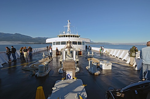 Although the sky was clear in Port Angeles, we hit fog within 15 minutes of departure. The crew shooed all passengers away from the bow of the boat and we went inside. We filled in our immigration paperwork and found a comfortable place to sit. I was feeling more than a little queasy from the rocking of the boat, but that cleared up soon enough. So did the fog. We went back out on deck as we came into Victoria Harbor. A seaplane was just landing. It was another beautiful day.
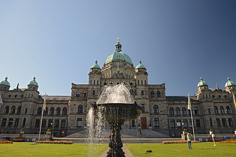 First up was the
 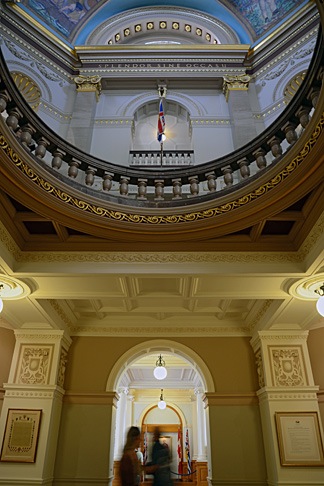 We were pleased to learn that the building was open to the public and wasted no time exploring the public areas inside. The building, which was completed in 1898 and restored in 1973 is in magnificent condition, full of wonderful architectural touches. I picked up the self-guided tour booklet but didn’t really consult it much. It was nice to simply wander around, from room to room, although I do wish we’d taken the guided tour.
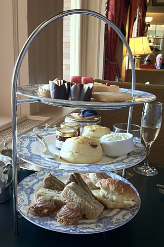 At 4 PM, we headed back to the Empress for tea. Despite our shabby appearance — I was wearing my usual henley t-shirt and jeans and Mike was similarly dressed — they sat us at a table by the window where we could look out at the harbor and watch the people go by. We started with a pair of champagne cocktails. Our waiter was excellent, recommending a tea that suited both of our tastes — I prefer mine without milk; Mike floods his with milk. Then he brought the customary three-tiered plate of goodies, including sandwiches, scones, and sweet treats. I’ve had afternoon tea about a half dozen times and this one was, by far, the best. Highly recommended.
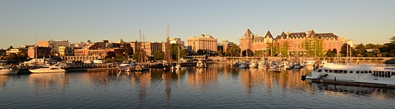
 I should mention that much of this was old growth forest. An absolutely huge tree grew close to the road and we got out to take a closer look. Its amazing to me that trees this large exist and that so many of them have been cut down. Actually seeing one is a real treat.
 Back on the road, we continued along Route 524 to Edmonds and got on line for the
  I brought along my camera. I didn’t really expect to find anything of interest to photograph, but on nearing the top of the first big hill — after an elevation gain of about 800 feet in 1-1/2 miles — I caught sight of a lone pine tree on a hilltop off in the distance. It reminded me a bit of
  As I continued the hike — my friend had gone up ahead because I’m so damn slow when hiking uphill — I got a little artsy with some weeds along the trail. I liked the way the sun shined through them. Remember, the sun was up ahead of me. Again, from what I could tell, the image looked interesting in the screen at the back of the camera. I felt good — as if I were getting some interesting shots.
 There were National Forest Campgrounds along the side of the river. I passed two before I reached the parking area and campground for Silver Falls. I parked and stripped off my gear, locking it up in my bike’s Givi saddlebags. Looking up, I saw the top of the falls — can you see it in the photo? It didn’t seem that far away.
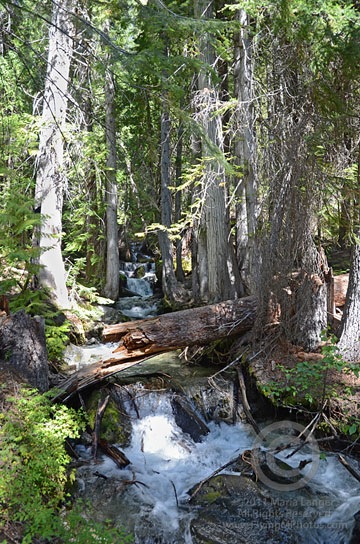 I immediately found myself in a deep, somewhat dark pine forest. As my eyes adjusted to the light, my nose picked up the scent of pine and moisture and my ears heard the sound of rushing water. I came upon the creek immediately — a healthy stream of water gushing over rocks between trees. For me — a desert dweller — it was a real treat.
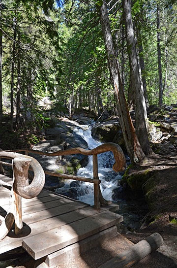 The path was well-maintained, with rustic protective barriers to prevent hikers from accidentally falling into the stream. The bridges were especially rustic looking, sometimes with curved logs making attractive rails. It was surprising to find something so attractively designed on a trail. I began to wonder how much of the trail dated back to the
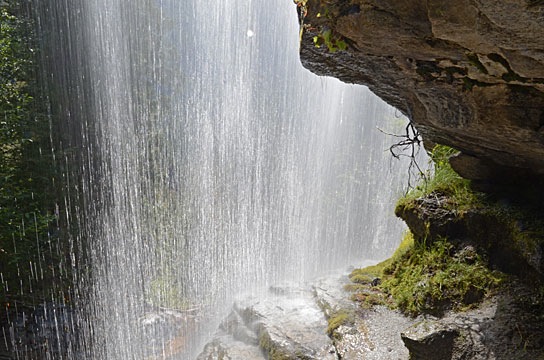
 But I stuck with it and was rewarded with a switchback and another climb. A while later, I was back alongside the stream at yet another streamside bench, photographing some beautiful purple flowers just past the peak of bloom.
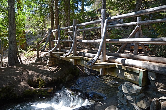
 Then I started down the other side of the creek. At first, it was one long flight of stairs after another. Then the trail moved away from the falls in a series of relatively level paths with switchbacks. In some places, the trail emerged from the forest into the sun; not only could I feel the heat on my skin, but I could smell it. Then back into the trees for cooling shade and pine aromas.
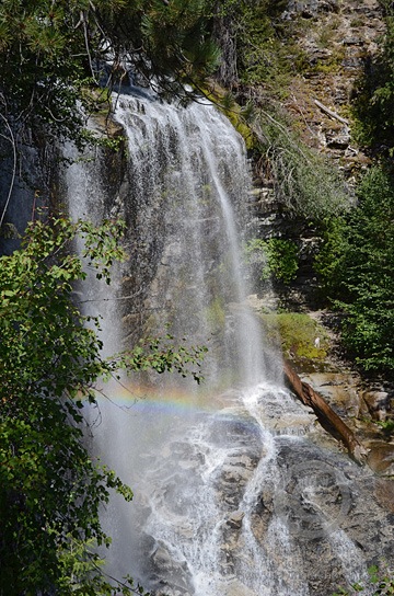 At one point, the trail came back to the falls just below where I’d walked along the ledge on the other side. The mist and sun worked together to produce a small rainbow. I did the best I could to capture the scene with my camera; I really do need to learn how to photograph waterfalls properly.