In which I do a lot of hiking, see unexpected wildlife, and do my best mushrooming while driving.
I slept great, waking at about 5:30 AM.
I made my coffee and sat down to finish up a blog post I’d started the previous week about an FAA inspection of my new old helicopter. Of course, I couldn’t post it. I had no cell signal at all and didn’t expect to get one for the rest of my time in the area. I was totally off the grid for the next four days.
I made breakfast: buckboard bacon, onions, wild asparagus, tomatoes, spinach, and eggs. While I ate, I began planning my day.
The First Hunt
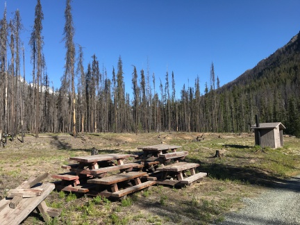
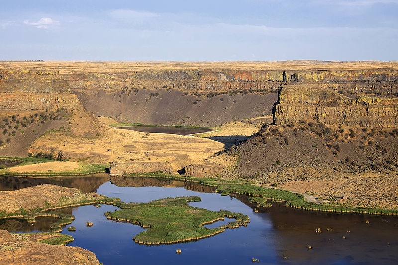
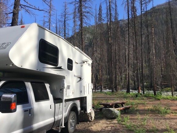
A look into the rest of the campground and beyond from near our campsite.
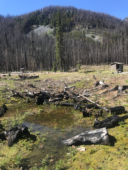
Since we were camped in a narrow part of the valley, it took a long time for the sun to hit the camper and the solar panels on its roof. Once the sun was on us — maybe at around 8:30 AM — it was time for a hike. I figured we’d head across the campground and into an area where more of the burned trees were still standing. I didn’t expect morels to grow in full sun so this would be a good place to start.
Although I initially packed a fanny pack with a bottle of water, small paper shopping bag (for mushrooms), my bright orange pocket knife, a Lara bar, and Penny’s treats, I decided that the hike would probably be short and I could just take was was absolutely necessary: my phone, which was preloaded with a map of the area in GaiaGPS so I wouldn’t get lost; my knife, and the paper bag. Yes, I left water behind. I didn’t expect to walk very far and it was still quite cool out.
I was wearing a long-sleeved knit shirt with a flannel shirt over that. I almost brought along a sweatshirt but (fortunately, as it turned out) decided to leave it behind.
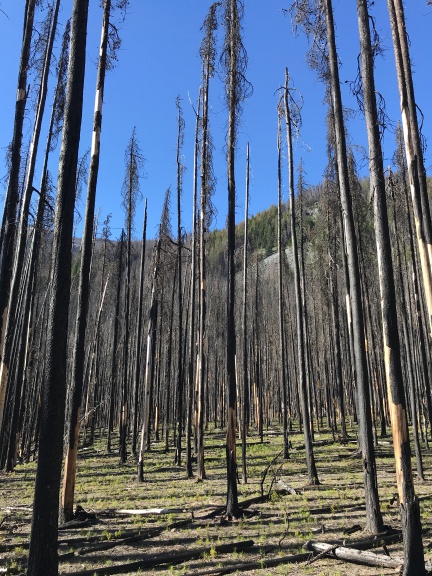
West of the campground was a forest of tall burned trees.
We headed west away from the camper, past the outhouses and stacked logs and picnic tables. Soon we were in the forest of burned trees. It was truly amazing how much damage the fire had done. All of the old underbrush was completely gone and young trees and other plants poked out of the sometimes very thick ash. All around us, the larger trees that had been burned but not toppled stood like silent sentinels. On a different day, it might have been creepy, but that morning was perfectly clear with lots of warm, bright sunlight. Soon, in fact, I had taken off the flannel shirt and was starting to feel warm in the long sleeved shirt beneath it.
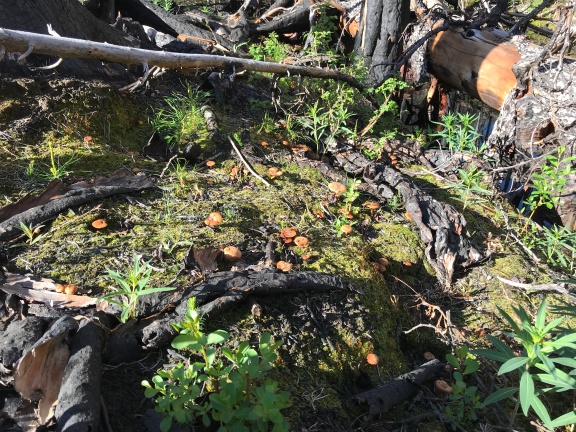
Among the new plants coming up on the forest floor were a multitude of mushrooms.
There were mushrooms everywhere. I have never seen so many in a bright and sunny place. I had no idea what they were, but I took photos. (I actually like photographing mushrooms.) I noticed three distinct varieties of what my friend Sue would call LBMs — little brown mushrooms. I thought for a while about gathering some of them to show when I met up with the group on Friday. They do a big mushroom ID thing on Saturday evening. But there were so many that I figured I could always collect them the next day.
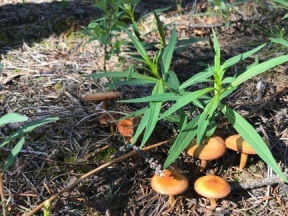
Seriously: I like taking pictures of mushrooms.
Did I see any morels? No. As I wandered through the woods, climbing up into an area that seemed to have more vegetation, I didn’t see a single morel. I started wondering why and came up with four possibilities:
- It was too early for them. It had been cold the night before — probably in the 40s. Someone somewhere had told me that morels need at least three nights in a row with temperatures in the 50s to come up. Was that true? Damned if I know. But I doubted it had been that warm at night at my current elevation of about 3100 feet.
- Someone else had beaten me to them. After the previous year, I knew this was a real possibility. There’s big money in morel mushrooms and a lot of people hunt for sale rather than consumption. They’re more serious and dedicated than I am. But other than a few footprints I later found on a trail, there was no sign that anyone else had been in the area recently. And the forest is huge; surely they couldn’t look everywhere.
- My mushroom eyes hadn’t switched on. Searching for mushrooms is a matter of turning on a very specific pattern recognition in your brain. I was obviously seeing mushrooms that looked like mushrooms. But morels didn’t really look like mushrooms. Maybe I wasn’t sufficiently conditioned to find them?

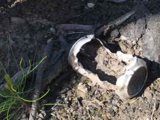
As this melted can hints, the fire got very hot.Morels didn’t grow there. Maybe it was too burned up? Maybe the fire had killed off the mycelia that the morels spring from. It certainly had been a hot fire — that was obvious later when I found a partially melted beer can near a trail. (And seriously: WTF? You can carry in a can full of beer but you can’t carry the damn can out when it’s empty?)
It didn’t matter what the reason was — at least not that day. The point is, I wasn’t seeing any morels.
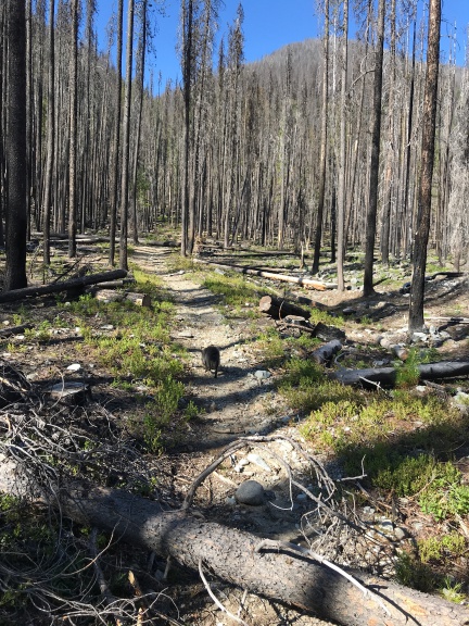
I came upon a well-worn trail that needed some work to clear away fallen trees.
I started heading back, swinging more north to put me on a different path for the return trip. And then I suddenly came upon a trail. I looked at GaiaGPS on my phone and, sure enough, the map I’d loaded in showed a trail. I traced its line on the map and decided it might be worth hiking up to where it crossed a stream. After all, mushrooms were really an excuse to get out hiking. I’d only gone about a mile and I really needed to do more. So I turned and followed the trail up the hill, hearing the sound of rushing water getting louder and louder as I went.
The trail needed work, too. This area of Washington, which is basically the foothills of the North Cascades, has tough winters. Under normal conditions, trees fall in heavy winds or with snow loads. But with so many dead trees weakened by fire damage, there were even more fallen trees than usual. They blocked the trail in more than a few places, requiring Penny and me to go over or around them.
The hike was all uphill, although not really very steep. The trail had gentle switchbacks that made it easier. Eventually, we wound up alongside a wildly rushing cascade of water that cut through the forest. The sound of the moving water drowned out any other forest sound.
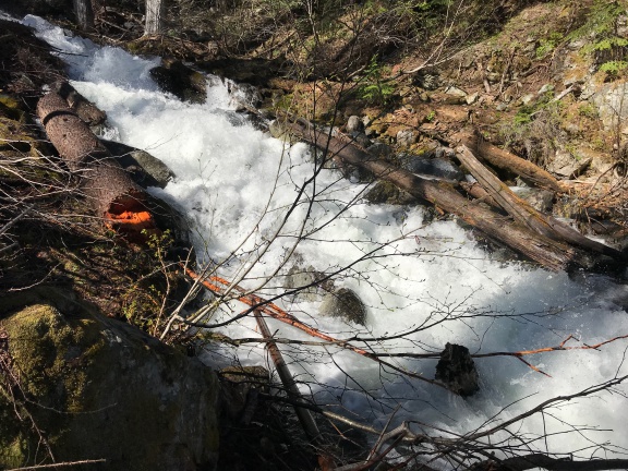
The trail took me to Shetipo Creek, which was roaring down the side of the mountain.
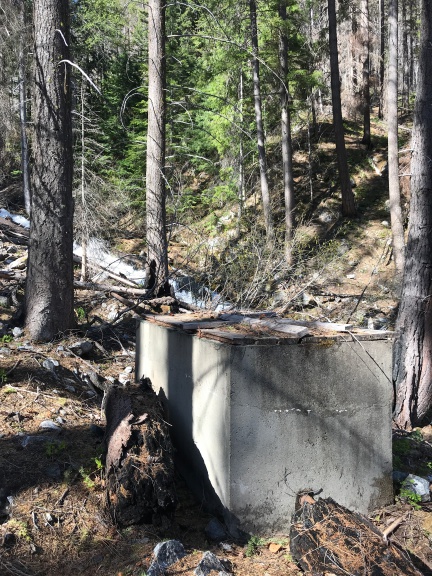
Until the fire, this tank and accompanying pipe system had brought water down to the campground from Shetipo Creek.
There was a concrete tank with wooden planks for a lid and pipes on either end. At one time, this system had taken water out of the creek and funneled it down through pipes, probably to the campground. I touched a hand to the outgoing pipe and could feel neither vibration or cold water running thorough it. I followed the incoming pipe upstream to where it went into the water. I wondered when it had been built and whether it was ever used. (The next day, I spoke to a ranger about it. He told me it had been in use until the fire when much of the pipe, which was plastic laying on the surface, had melted.)
I consulted the map and saw that I’d left the mapped trail some time ago. Odd; I hadn’t seen a fork in the trail. In any case, we couldn’t continue on a trail so we headed back. I felt done.
It was an easy hike back to the camper. I always did hike best downhill. It was around 10 in the morning and had gotten very warm. I worked up a good sweat and could go for a drink of water. I think that motivated me to get back quickly.
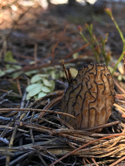
The first morel I found this year was right beside a well-worn trail.
I was near the very bottom of the trail, not far from where it ends at a parking area near the entrance to the campground, when I looked down and saw it: a morel mushroom. It was a lighter color than I’d been expecting and it was relatively small. Since I’ve never found just one morel in a place, I searched all around it. But it was there by itself.
Of course, I cut it and stuck it in my bag.
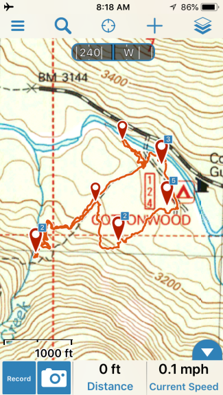
Here’s the finished track in GaiaGPS for my Cottonwood Campground area hike. You can see where I diverged from the trail. The waypoint markers represent places I took photos within the app; the numbers are the number of photos there. If I remember, I’ll upload the track and photos to the GaiaGPS website when I get home and link to it here.
Then I spent another 20 minutes poking around that area, looking for more. I came up empty.
The irony of this: although I had hiked 1.8 miles, the mushroom I found was within 100 yards of my camper.
Another Campground, Another Hike
We went back to the camper, had something to drink, and had a snack. That mean half a liverwurst sandwich for me and some chicken and kibbles for Penny. By then, I’d decided that I’d be better off continuing the hunt at lower elevations. There were a few more campgrounds along the road on the way back to Silver Falls. I’d find a spot in one of them and try another hike.
So I stowed all the loose belongings in the camper, loaded Penny up in the truck, and headed out.
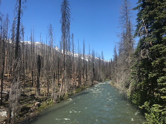
I stopped on the bridge as I was leaving the campground to take this photo. The fire didn’t stop at the river.
It didn’t seem to take long to get to the next campground downriver from Cottonwood: Three Creek. It was a tiny campground, also damaged by fire, and I couldn’t figure out how many sites it had. I backed the camper into the one that was most intact, mostly to get it out of the way in case someone else happened to come in. That was unlikely. I hadn’t seen a single vehicle or person all day.
I didn’t feel very hopeful about this spot, so I didn’t gear up. By this time, I’d changed into a tank top and had the flannel shirt on over it as a sort of lightweight jacket. I put my knife in my pants pocket and my phone in my shirt pocket. But I didn’t bother tracking my hike. I don’t think we even did a half mile. We skirted around the campground, crossed the road, wandered around the forest there until we found a small creek, followed the creek back to the road, crossed the road again, and made our way back to the campground. Along the way, I found an archery arrow. Lots of mushrooms but no morels. The elevation was probably around 2900 feet. Still too cold? Or too burned?
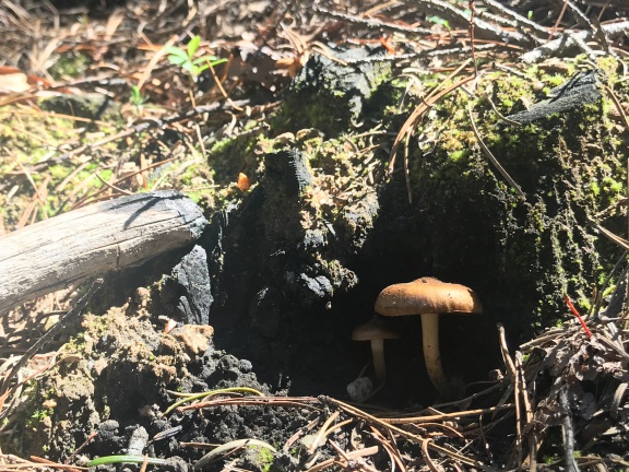
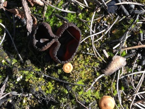
The reclusive little brown mushroom and its offspring wait at the mouth of its cave for mushroom hunters with cameras to pass by.
Drive-By Mushrooming
We got back into the truck and continued on our way. I drove slowly, not in any hurry. For much of the drive, the gravel road was narrow with a steep embankment of two to 20 feet in height on the left side of the road. As I drove, I scanned this little hillside with the crazy idea that I might see some mushrooms.
Not so crazy, it seems. I saw what looked like a morel. I might not have the best eyesight, but my vision is finely tuned for pattern recognition sometimes.
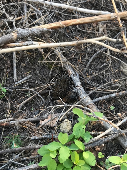
You see the two morel mushrooms in this photo, right? Try spotting them from a moving truck.
I found a wider place in the road and pulled over as far as I dared. I pushed the button that would fold in my side mirrors just in case someone came by and needed to pass. I shut the engine and, leaving Penny in the truck, got out with my knife and that paper bag. I walked back down the road to where I thought I’d seen the mushroom growing out of the hillside. Before I reached that spot, however, I saw another one. And another one. And another one.
They were all (barely) within reach. I cut them off, one after another. I got to the spot I’d seen the first one from the truck and found three more. They were all the dark brown morels I’d been expecting to find and they were all large.
Of course, a truck drove by just as I was prepping to cut one high on the hillside. I’m sure the driver knew what I was up to. I waved lamely. He waved back. Then he was out of sight around a curve in the road.
I continued hunting along the embankment but came up empty. So I headed back along the road toward the truck. I found a game trail that climbed up the embankment and followed that, continuing my search on higher ground. Nothing. I came back down, now past the truck, and headed back.
I found three more. I cut the first two and was about to cut the third when I remembered a promise I’d made to myself: I wouldn’t take every mushroom I found. I’d leave behind small ones that were hidden behind brush and difficult for others to find. This way, I’d help prevent the morels from being over harvested so they could continue to grow. This last mushroom was a perfect candidate, so I left it right where it was.
I got back to the truck and stowed the bag of mushrooms inside the camper’s back door where it was likely to be cooler than the truck’s dashboard and safer than the passenger side footwell.
Of course, I kept looking as I drove. But other than finding one huge one from the truck much later in the day, I had no further success.
I was passed by not one but three Forest Service trucks going the same way I was. In each case, I pulled over to let them pass. They probably thought I was driving so slow because of the camper and the unpaved road.
At North Fork
I passed Spruce Grove Campground for two reasons: first, the tight right turn would have required multiple maneuvers to make, and second, the sign said “Trailers not Recommended.” Although I wasn’t pulling a trailer, I did have a long, high profile vehicle that required more than the average amount of space to turn around. I had no idea what the condition of the forested campground would be and didn’t feel like dealing with a challenge. So I kept going.
The next campground was North Fork. There was a barricade with a Road Closed sign that had been moved out of the way. I read that to mean that it was open so I pulled in.
There was a lot of debris all over the campground. Burned and fallen trees, mostly. The mess left from winter. Again, I had trouble identifying more than a few campsites. I backed into one along the river which, unfortunately, was not level. It would do, however. If I decided to spend the night, I could always put the back wheels up on blocks.
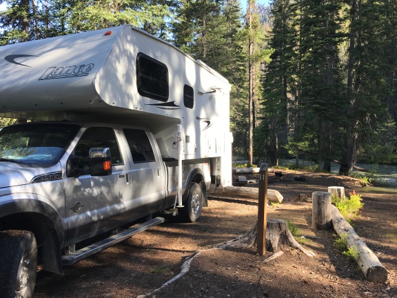
Our “campsite” at North Fork Campground.
I made lunch: sardines with minced onions on a bed of mixed greens with balsamic vinaigrette dressing. I drank water. I gave Penny some sardine juice — they had been packed with olive oil — over her kibbles and she ate them up. Then I cleaned off the morels I’d found so far, put them in a plastic container, draped a wet paper towel over them, and stuck them in the fridge.
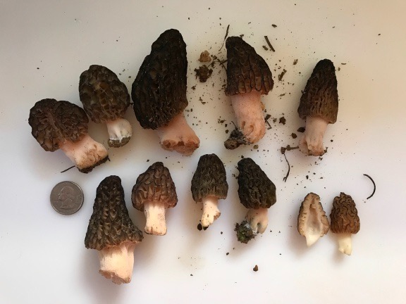
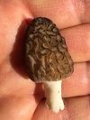
Here are the morel mushrooms I’d collected that morning, before I cleaned them. The one cut in half is the first one I found. Morels are hollow inside.
The elevation there was about 2650 according to the map I’d loaded in GaiaGPS. There was a place called Entiat Falls just 1700 feet downriver. I thought it might make a good hiking destination with a mushroom hunt along the way. I packed the fanny pack with the paper bag, a pair of binoculars, a snack bar, and a bottle of water. Then I grabbed Penny’s leash and we headed out.
I soon discovered that there was no trail from the campground to the falls. A rushing stream — North Fork — crossed the road at a bridge and the only way for us to cross it to continue downstream was to get on the road. On the other side, we went back into the woods, but the going was tough with lots of marshy areas. It didn’t take long before I got tired of trying to find my way and headed back to the road.
Of course, by that time, we were abeam Entiat Falls. There was a parking space there with an obvious way down to the falls. “Falls” is being generous — all it really is is a place where the river plunges over some really big boulders. It was rushing like mad with a thundering sound and lots of spray.
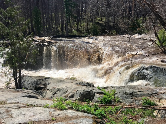
Entiat Falls wasn’t much of a waterfall, but the water sure was moving fast and loud.
I wasn’t done walking yet so we continued down the road. Because we were on the road and not in the woods, I put Penny on her leash. We walked along the oncoming traffic side so I could scan the embankment for more mushrooms. The road was paved there and rather pleasant, with no traffic at all. I could hear birds and the rushing water off to my right and not much else. The temperature was warm, but I was comfortable.
I checked GaiaGPS to see how far I’d gone. 8/10 mile. I decided to go a full mile before turning around and kept walking, scanning the ground at the side of the road, with Penny leading the way on the leash.
I don’t know what alerted me to the movement ahead. Maybe it was Penny. Maybe it was just something I caught in my peripheral vision. My brain said deer — after all, I’d seen at least a dozen of them in the previous 24 hours — before my eyes locked on to what it was.
It wasn’t a deer. It was a bear.
A big, black bear on all fours ambling across the road about 100 yards ahead of us.
Shit.
I turned around and walked as fast as I could back the way we’d come, dragging Penny along with me. To her credit, she didn’t bark. I kept turning around to make sure the bear wasn’t following us, remembering everything I knew — and didn’t know — about bears. Was I supposed to make noise or be quiet? Was I supposed to run like hell or not turn my back on it? Did bears eat people? Small dogs? Or did they eat trees like pandas and koalas? Surely I’d lose a race with a bear. I was so damn out of shape.
And that out-of-shape feeling was confirmed the farther I speed-walked away. Soon I was sweating, panting, nearly out of breath. And I knew exactly how far away the truck was: nearly a mile! If this bear came after me — or if it had friends in the woods up ahead of us — there was no way I’d be able to beat it tback to the truck.
But there was no chase. The bear, which must have seen us, was simply not interested in us. There were no other bears in the area — at least none willing to put in an appearance. After speed-walking for about a half mile, I finally slowed down to catch my breath. I still wanted to get to the truck and camper as quickly as possible, but I wasn’t interested in having a heart attack along the way.
We reached the bridge and, just before crossing it, I looked down and found a morel mushroom. Go figure, eh?
I looked around a bit, but didn’t find any others. No worries. The only thing I wanted to do was get into the camper, close the door, and have a nice, cold drink.
Five minutes later, that’s where I was.
Siesta
I drank a lot of orange juice mixed with water. I used two plastic cups to make ice in the freezer; I had no ice trays with me. Then I crawled up onto the bed to relax and cool down.
Within 10 minutes, I was dead asleep with Penny on the bed beside me.
I slept lightly for the next three hours. I almost got up once but my body told me I wasn’t ready yet so I went back to sleep.
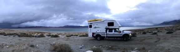
Finally, I dragged myself awake. I looked outside and saw the storm clouds I’d been expecting that day. While it’s true that I couldn’t go online to check the weather, I had checked it before leaving home. Rain was definitely expected and there was the dark storm cloud that would bring it.
I realized that the trees around me were kind of fragile and that a storm with strong winds could topple one or more, possibly onto my camper or across the road. The narrow part of the road between North Fork campground and Silver Falls had looked prone to flooding. I suddenly realized, with my half-awake brain, that I didn’t want to get stuck out that narrow bit of road. It was time to move on to find another place to spend the night and ride out whatever storm might be coming.
So I stowed the loose belongings again, climbed into the truck with Penny, and headed out.
Needless to say, I was looking for bears along the road about a mile from where I’d been parked. No joy. But a little farther down the road, my drive-by mushrooming skills paid off again: I found a humongous morel. I hopped out of the truck, ran across the road, and cut it off for my collection. That made an even dozen.
National Forest Camping
One of the things I like best about National Forests is that unless otherwise posted, you can camp just about anywhere you can park. I had a few ideas for spots just upriver from Silver Falls that I’d seen the previous year and that’s where I headed.
Along the way, where the road got very narrow with embankments on either side, I saw a handful of deer. No more bears.
I drove past the gate that had been closed the previous year and made a right turn. There was a campsite down along the river there, but it was already occupied. I crossed the bridge. The campsite on the other side of the river was occupied, too. I followed the paved road around to the south, noting one empty spot that would do in a pinch. But what I was looking for was a left turn on a narrow gravel road that wound down into the forest, closer to the river.
The spot I remembered was already taken, but there was another spot I didn’t remember about 100 yards before it. It was certainly large enough for me to get the truck and camper in. I almost turned into it, but then I realized that would have my back door facing my neighbors. So, instead, I backed in so my camper door would face the woods and a tiny creek that meandered past.
I got out to check the level inside the back door of the camper, then got back into the truck to reposition. I did this twice. Finally, it was level enough for comfort. I rolled up the truck windows, shut it off, and got out with Penny and my laptop, which had been charging in the truck all day.
The trees around us looked healthy and not likely to topple in a wind storm. I took out my little grill and set it up on the ground outside the back door. I screwed on the propane can and fired it up. Soon I was grilling up a nice piece of salmon and the last of the wild asparagus I’d gotten from a woman who I’d helped with a bee problem the week before.
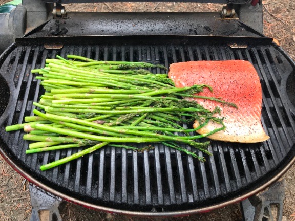
Salmon dinner on the grill.
Thunder rumbled overhead, but the rain didn’t start until after I’d brought in my dinner. I put some of it aside to include in an omelet later in the weekend and ate the rest. It was good, although I think I would have enjoyed the salmon more if I’d cooked it a bit longer.
By the time I was done eating, it was raining hard. It would continue to rain hard all evening and into the night.
I spent some time working on a blog post about the previous day’s trip up to Cottonwood campground. By 9 PM, I was exhausted — which really surprised me, given the length of my nap earlier in the day. I was dead asleep by 9:30 PM while the rain pattered on the roof overhead.