Another chapter of my old life ends.
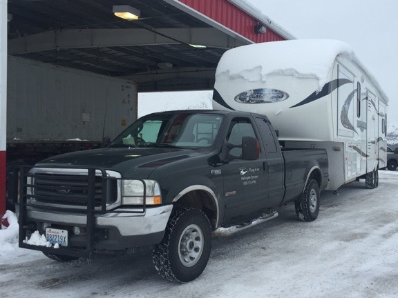
On Monday, I delivered my 36-foot fifth wheel Montana Mountaineer RV, affectionately nicknamed “the Mobile Mansion” to its new owners. Yesterday, I met them at the bank to have the paperwork notarized and get my check.
Early Life of the Mobile Mansion
I bought the Mobile Mansion brand new back in 2010 in Quartzite, AZ. I got a great deal on it. The Great Recession was killing RV manufacturers and dealers; by January 2010, Quartzite dealers were desperate to unload brand new RVs.

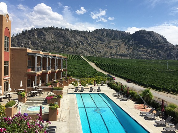
Here’s the Mobile Mansion parked at the golf course I stayed at in Quincy, WA, for about two months each summer. (I now hire pilots to work my Quincy contracts.)
It was the second — well, fourth if you count the popup camper and horse trailer with living quarters — in a line of RVs I’d owned since the early 2000s. Like its predecessor, a Starcraft hard-sided camper with pop-out beds, It was a business asset for Flying M Air: I bought it as a place to live when I traveled for my flying work. I’d begun working in Washington every summer in 2008 and wanted an affordable and comfortable place to live while I was there. The Starcraft was affordable but not comfortable. The Montana was very comfortable mostly because it was very large. I got a big one because I expected that I’d be living in it for four to six months a year with the man I was married to and our mid-sized dog. I wanted us to have plenty of space. I wanted it to be a true home away from home. When I bought it, I blogged that it was the “perfect” RV.
A Temporary Home for the Homeless
When my marriage fell apart in June 2012, I was living in the Mobile Mansion in Washington State, where I was working for the fifth summer in a row. I didn’t bother bringing the Mobile Mansion back home to Arizona at the end of the summer. Instead, I stored it in a friend’s garage, along with my boat. I’d need it in Washington the following year no matter what happened, so it made no sense to bring it home.
I did move it down to California in February 2013 for the frost control work I started there that year. It was a lot of fun to live part time at an airport with my helicopter parked a few hundred feet away.

The Mobile Mansion parked alongside a hangar in the Sacramento area. You can see my helicopter parked on the ramp at the left side of the photo.
In May 2013 when the court stuff was finally done and my wasband finally agreed to a division of personal assets in our Wickenburg house and Phoenix condo, I moved out of Wickenburg permanently. By that time, the Mobile Mansion was back in Washington, settled in for my summer work, and I moved right back into it.
I lived in it for most of the next two years. I traveled a bunch in the winter, as I usually do, and had a three-month housesitting job during the coldest months of the winter of 2013/14 when living in the Mobile Mansion parked outdoors would have been tough. The following winter, the shell of my new home was finished and, when I wasn’t in Arizona or California, I lived in the Mobile Mansion inside the RV garage. I had a full hookup in there: 30 amp power, water, and sewer. It was comfortable, but cave-like — sort of like that Phoenix condo I’d hated so much — and it really motivated me to finish up my living space upstairs.

The Mobile Mansion was my home and base of operations while my new home was being built. I even set up a time-lapse camera on one of the slides to record the whole building process.
In early April 2015, I moved upstairs, sleeping on an air mattress on the bedroom floor. The shower wasn’t done yet, so I still showered down in the Mobile Mansion in the garage. But by the end of the month I was mostly moved in, with my furniture in place. Although my home wasn’t 100% complete, I was done living in the Mobile Mansion.
Or so I thought.
The Mobile Mansion stayed in the RV garage until July. I’d been playing around with AirBnB, using the full hookup campsite at the edge of my driveway as a rental and getting some activity. But in July, I moved the Mobile Mansion back outside and parked it near where it used to be. I pulled all of my personal items out of it, leaving only what was needed for guests. And then I put it on AirBnB. Amazingly, I was able to rent it almost every weekend right into October, getting $80/night with a two night minimum.

People paid $160/weekend to live in the Mobile Mansion with it parked right where it is in this photo. (And no, the helicopter usually wasn’t parked in the side yard.)
(I could probably write a whole blog post about squeezing money out of assets without a lot of headaches. I’ve gotten pretty good at it.)
Mobile Mansion for Sale
By September, I had decided I definitely wanted to sell the Mobile Mansion. I wanted to travel for the winter but I wanted a smaller rig. I’d already started shopping for one. At the time, I was thinking of a much smaller bumper pull. I listed the Mobile Mansion in various places, hoping to sell the truck with it.
After that last AirBnB rental, I took everything out of the Mobile Mansion, gave it a good cleaning, and dropped it off at an RV sale lot in East Wenatchee. The folks there were pretty confident they could get my price.
They came in with two offers, both of them very low. Bargain hunters looking for “motivated” (read that desperate sellers.) I didn’t have to sell the Mobile Mansion. It was fully paid for and not costing me a thing to keep. I’d even made nearly $2K using it as a rental for part of the summer.
By December, I’d decided to go south for the winter. My friends were camping out in the Colorado River backwaters and I wanted to join them. I figured I’d sell the Mobile Mansion while I was away and come home with a different rig. So after my Christmas skiing trip, I went to the sale lot with all the gear I’d need for the winter, packed up the Mobile Mansion, hooked it up to my truck, and headed south on what was supposed to be a three-month trip.
The last of the snow melted off the roof when I reached Blythe, CA.
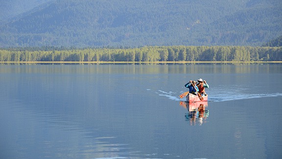
Despite the in-transit trials, I had a great time. It was good living off the grid with my friends, soaking up the sun, fishing, paddling, horseback riding, and shopping for deals in Quartzsite. I almost sold the Mobile Mansion once — I had a decent deal to trade it for a truck camper and still get cash in hand. But I wasn’t mentally ready for such a huge downsizing. I made some improvements to the Mobile Mansion, thinking I might keep it after all.
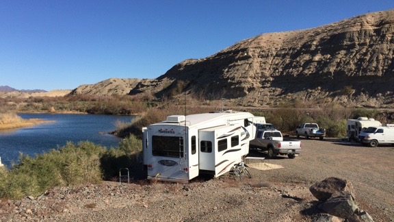
Living in Arizona along the Colorado River in the Mobile Mansion last winter was tough. Not.
I regretted not taking that offer when I left Arizona in February and started my trip to California for my frost control work there. Truck trouble stranded my truck and the Mobile Mansion in southern California, really screwing up my plans. I went home, fetched the helicopter for my contract, and spent some time in the Sacramento area with it. But without the Mobile Mansion to live in, I didn’t want to be there. I went home, leaving the helicopter, my new used truck, and the Mobile Mansion scattered around California. It wasn’t until April that I was able to fetch everything and bring it home.
After cleaning the Mobile Mansion out yet again, I brought it right to a sale lot in North Wenatchee. Once again, the sales guy told me how sure he was that he’d sell it — possibly even within a few weeks.
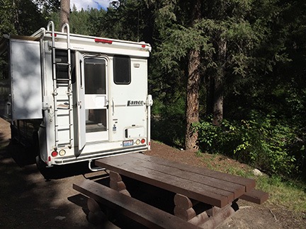
But I didn’t wait for the Mobile Mansion to sell before getting on with my plans. (I am so done waiting for someone else to do something to move forward with my life.) I bought a truck camper to replace it and almost immediately put it to use. After an overnight “shakedown tour,” I put it to work housing one of the pilots who worked for me in Quincy. (I suspect he would have been more comfortable in the Mobile Mansion. Oh, well.)
The sales lot guy was unable to sell it. I think it’s because he was asking so much more than it was worth, hoping to turn a tidy profit on my rig. And the fact that when he didn’t feel like coming to work, he didn’t — so the lot was closed more often than it was open. (Needless to say, he won’t be seeing me again.)
It Pays to Wait
Fortunately, I hadn’t stopped telling the people I know about it. And two of them were interested — but not for the price the guy on the lot was asking.
We agreed on a price. Ironically, it was more than the price my wasband had accepted on our jointly owned 40-acres of vacation property in Northern Arizona the month before. (Desperate sellers will take anything. Yes, I accepted the low offer, too, but the only thing I was desperate about was finally ending any ties I had to the sad sack old man I’d married 10 years before. The money was nothing. Almost literally.)
And I didn’t have to split the proceeds with anyone.
I delivered the RV to the new owners on Monday. I let one of them use my truck to back it into their hangar, which was just deep enough for him to back it in. I showed them how to unhook it. I gave them the full tour, including the “secrets” I’d learned about it in the five years I’d spent so much time in it. That took nearly an hour. I had mixed feelings as I was doing it, but I think the overwhelming feeling was that of relief.
Yesterday, I met them at the bank where we signed and notarized the title and other papers and I got my check. After handshakes and even a hug, I left them and went right to the bank to drop off the check.
Although I’m a tiny bit sad about closing the Mobile Mansion’s chapter in my life, I’m also very happy to do it. To me, the Mobile Mansion was a constant reminder of broken promises, miscommunication, and lies. Although I’ll miss its spacious comfort when I travel, I’m very glad it’s gone.