Summer 2016 Road Trip, Day 6: Chilliwack Lake to Hozomeen Campground

Back over the border to the U.S.

It was just getting light when I woke up. The forest canopy over my campsite was too dense for me to get an idea of the weather, but it wasn’t raining.

I made coffee and settled down at the table to finish up the two previous day’s blog posts. I needed to add the photos. That’s the most time-consuming part because it requires me to choose the photos I want to illustrate what I’ve written open them in an image editing app, crop them, and then save them as JPEGs. Then I have to import them into just the right place in my blog post and write captions. (I’ve got a blogging app I’ve been using for years — it’s called ecto and is no longer supported by its author — and I’ve got it all tricked out with macros that make blogging quick and easy for me. When ecto stops working, I don’t know what I’ll do. I’ve tried other tools that just don’t seem to do the job I need them to.)

I finished up that Trader Joe’s almond danish, too. Had to do it. Didn’t want it getting stale.

Chilliwack Lake Hike

I was done by the time the sun started shining on the trees around me. Time for a walk. I still hadn’t really seen the lake. According to the map I had, the trail I could pick up out behind my campsite would take me right to it. So I finished getting dressed, put Penny on her leash, and set off with my camera.

The trail was wide and carpeted with evergreen needles. The trees formed a canopy over us. Each campsite had a small trail running from it to the larger trail, but when we’d passed the last campsite, that stopped. We headed deeper and deeper into the woods, without any sound from the campground.

I met up with a woman walking two border collie mix dogs. We stopped to chat while Penny and the dogs did their dog greeting things.

Further along the trail, we met up with a woman who seemed absolutely terrified of Penny to the point that she walked off the trail as we approached. I kept Penny’s leash short until we’d passed. That was weird. Penny barely noticed her.

Lakeside Trail at Chilliwack Lake
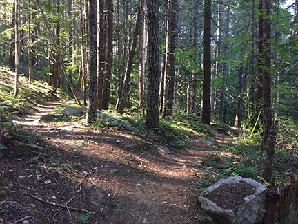
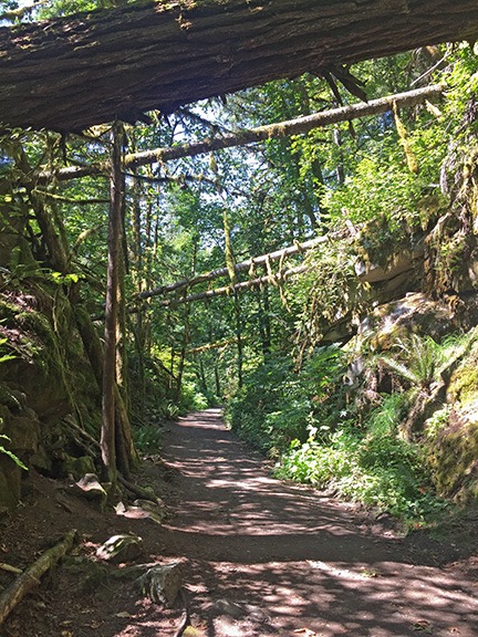
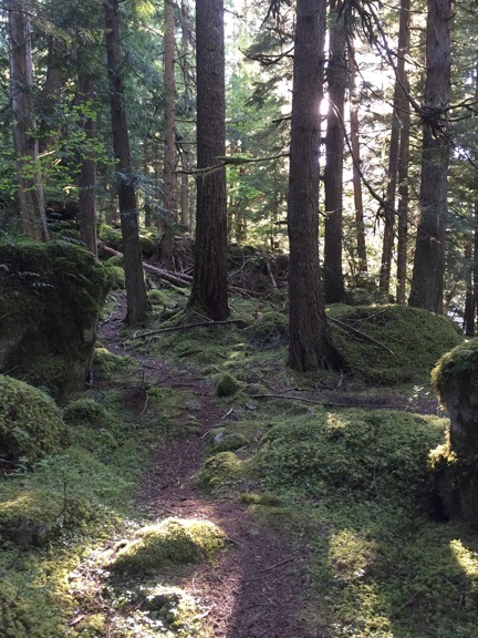
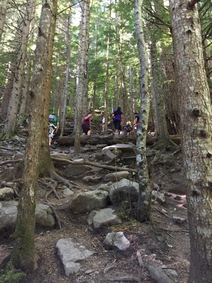
One of many narrow trails that wound through the woods near Chilliwack Lake.

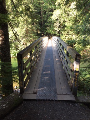
The trail took me down to the a footbridge where the Chilliwack Lake dumps into the Chilliwack River. The water rushed by as Penny and I crossed the bridge. The trail continued up to Radium Lake, which I was not interested in visiting, so we doubled back across the bridge and found another trail that paralleled the northern shoreline of the lake, taking us back toward the campground and boat launch. Soon we were among tents and RVs, not far from the site I’d almost stayed in the previous day.

Bridge across Chilliwack River Trailside Sign
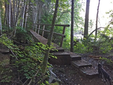
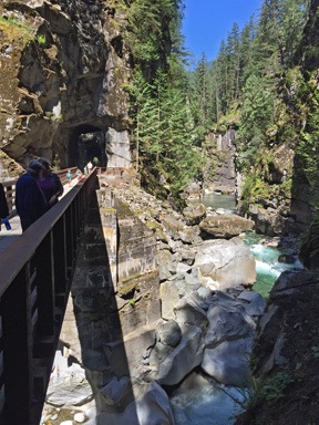
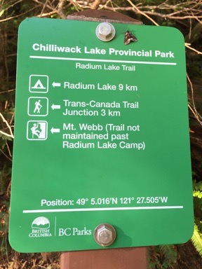
Left: The bridge across the Chilliwack River at the outlet of the lake was rustic but sturdy. Right: A typical trail sign in a Brtitish Columbia park is full of useful information about distances, trail conditions, and even exact location.

Early Morning at Chilliwack Lake
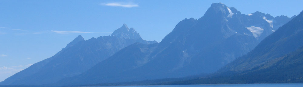
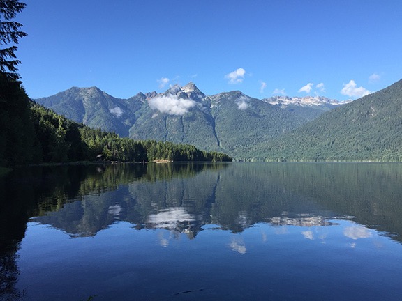
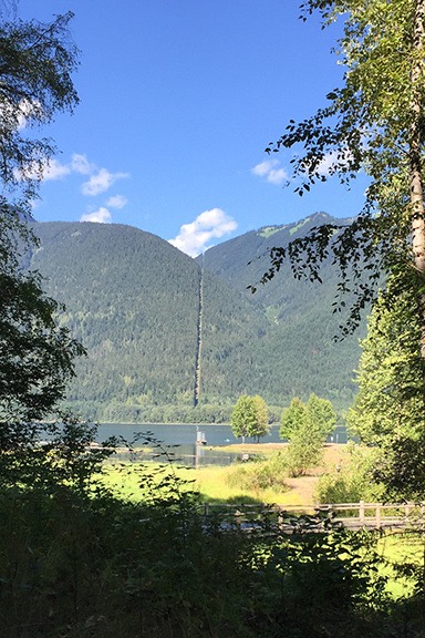
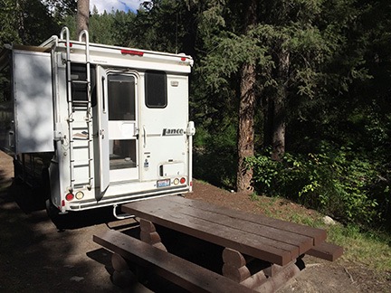
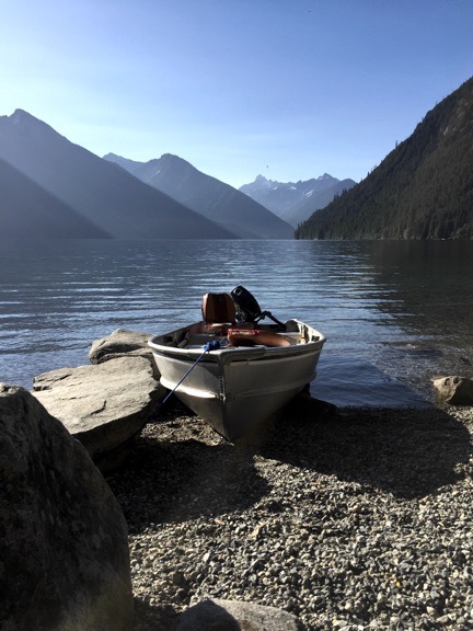
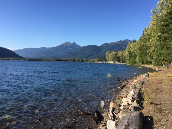
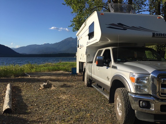
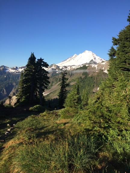
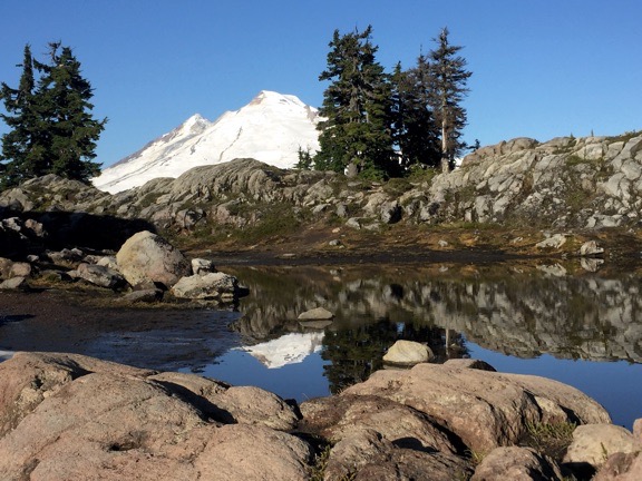
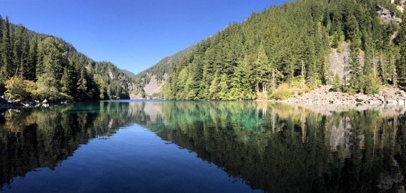
Early morning at Chilliwack Lake.

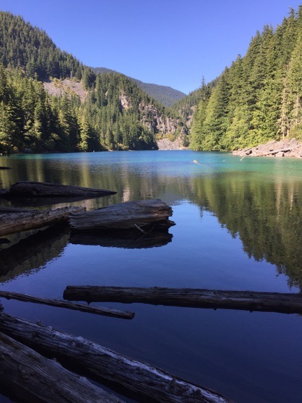
I found another trail down to the beach and followed that. Boats were tied up along the shoreline there, waiting for another day of fishing or water sports. The lake’s water was clean and clear; the mountains around the lake were majestic, robed in thick green forests. It looked just like you’d expect a Pacific Northwest lake to look. Picture postcard stuff. Was I starting to get numb to all the magnificent scenery around me?

We walked back up to the campground and headed back to our site. I chose one of the other trails that cut through the woods in the approximate direction I wanted to go. I realized that the whole park was criss-crossed with a network of unmarked trails. Once you were 50 feet or so down a trail, you were in woods so dense that you couldn’t see any signs of campgrounds or people. It was kind of pleasant, but I expect it would unnerve people without a good sense of direction or situational awareness.

Chores before Departure

Back at the campsite, I did the dishes and packed up. On the way out of the campground, I made one stop: at the dump station. I didn’t need to dump my tanks — I’d done that two days before on the way to Mount Baker. But I did want to top off the water tank. My fresh water system seemed to be having a pressure issue and the pump would go on when I wasn’t using the water. I suspected it was because the water level was low. One way to test that theory was to top off the water level and see if the problem persisted.

There was a man with a motorhome filling his water tank when I arrived. He was a little older than me and wore a knit cap and small-lensed sunglasses. We chatted for a while — hell, I’ll chat with nearly anyone. We talked about our rigs and their pros and cons and traveling to Arizona and all kinds of things. The water spigot did not fill very quickly so we had at least 15 minutes to talk. I realized that I’d have to either pull out a hose to reach my fresh water fill port or turn my truck around. So when he was done and we said our goodbyes, I followed him out, turned around, and pulled in going the wrong way. As my tank filled, I told the folks behind me (or in front of me, I guess) what I was up to so they didn’t have to wonder. It seemed to take forever for my tank to fill; I guess it was emptier than I thought.

I toyed with the idea of taking the road all the way down to the south end of the lake, but decided against it. Instead, I headed out the way I’d come in. Without a cell signal, I wasn’t sure about how to get to my next destination, but I figured I’d pick up the highway — and a cell signal — in Chilliwack. (Note to self: Get paper maps of all destinations prior to trip departure.)

On the Road Again

I paid closer attention to the road that I’d taken down to the lake the day before. I realized that my blog description wasn’t quite as clear as it could have been. I saw that it was mostly straight through a heavily forested area. It was the kind of area where they clear cut trees in big areas but leave the trees close to the road intact, to hide the cutting. But you can easily see the bright patches through the trees along the road, making it clear that there are no trees 50 or 100 feet in. You can also tell the area is heavily forested by simply looking up a the hillsides where there have been clearcuts in the past. I’ve seen this all over the northwest, particularly in Oregon and Washington. When you’re in a helicopter, these areas are hard to miss.

The road came close to Chilliwack River in several places. In one area not far from the city of Chilliwack there are rapids where kayakers practice. I’d noticed it on my way in and decided to stop. I got out of the truck with my camera, leaving Penny behind. And who do you think I ran into right near the river bank? The same guy I’d chatted with at the campground dump station.

We must have talked for another 30 of 45 minutes. Travel, politics, relationships, trucks. He told me how worried Canadians are about our elections. About how a Donald Trump presidency would make us the laughing stock of the world. I told him that Canada is going to need a wall if he gets elected.

I managed to get some photos of kayakers coming through the rapids as we chatted. Unfortunately, they’re all on my Nikon so I can’t add any to this blog post until I get home.

Although I think we could have talked all day, I reminded him that I was facing a two-hour drive to my next destination and was hoping to get a hike in there before dinner. So we went our separate ways and I got back on the road.

There was traffic in Chilliwack. I debated stopping and using my cell phone connection to publish the two blog posts I’d finished but decided to wait until I got to Hope, where my next exit was. By this time, my Internet connection was working fine in the car and Google was providing driving instructions. I got on the highway and headed east again.

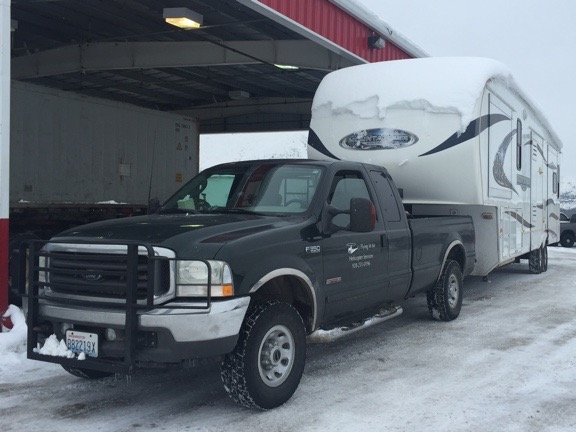
I drove at the speed limit — after using my glasses to figure out what 110 kph was in mph (almost 70). The road was just curvy enough that I didn’t feel comfortable going any faster with the Turtleback on top. I’m starting to think that’s how they establish speed limits: put a camper on the back of a pickup and drive as fast as they can. When the load starts feeling a little unstable, that’s the speed limit.

There was nothing remarkable about the drive. There seldom is on a freeway. That’s why I tend to avoid freeway driving on a road trip. If I wanted to move quickly between two distant points, I’d fly. Driving is to be enjoyed, whenever possible. Back roads offer an insight into the way people in an area live. They give drivers a chance to see the world around them when they’re not doing 70 mph.

One thing I did notice, though: Canada has the same familiar brands we have in the U.S. The first thing I noticed after crossing the border was a Costco, followed immediately by Lowes. There are all the same fast food places, there are Starbucks everywhere. Banks and supermarkets had different names. Of course, I wasn’t on the freeway when I noted all this. Can’t notice much at 70 mph.

The Road to Hozomeen

Google alerted me to my exit up ahead, one of the first in Hope. From there, it had me turn south on a relatively narrow road with neglected pavement. I drove past a row of small, condemned houses alongside a creek and then a residential area. And then I was heading south toward another provincial park and the border. I’d gone at least 10 miles before I remembered my planned stop at Hope to publish those blog posts. Oh, well. It could wait another day.

The road was in sorry shape. This was not a surprise. All the reviews I’d read about Hozomeen mentioned the road. It was 38 miles from Hope to the campground and although I’m not sure what the speed limit was, I was able to keep my speed at about 30 to 40 miles per hour. The road was actually worse on the north end because it also led to handful of lakeside and riverside provincial parks that, according to the ranger I met later at Hozomeen, were pretty popular with the locals. At a certain point, the road gave up any pretense of being paved and continued with a hard-packed gravel surface that had potholes but very little washboarding.

Although I’d lost my cell phone signal not far from the beginning of the road, GoogleMaps still showed my route with an estimate how how much time/distance I had left. I realized after a while that it was counting down the minutes faster than real time — I suspect I was going faster than Google thought I would.

Cars, some pulling trailers or boats, passed me in the opposite direction. Maybe ten of them total. There was no one in front of me and no one behind me.

I reached the turn for Ross Lake Campground in Skagit Valley Provincial Park and turned in. This would be plan B for the night. The campground was remarkably similar to the one I’d spent the previous night in: wooded, decent sized sites with trees or brush for some privacy. The sites along the lake — I’d reached the north end of Ross Lake at this point — were either taken or reserved. But there were plenty of empty sites, many of which would meet my needs. So if Hozomeen didn’t pan out, this would work.

Boundary Sign
This is the US sign looking toward Canada. The Canadian sign is on the flip side. This sign post can’t be more than 3 feet tall.

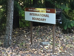
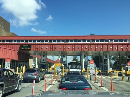
I left the campground and continued south. There was a turn for a day use area on the lake. And then a nondescript sign that said International Boundary. I kept driving, slowly now, looking for the border station where I’d need to stop and show ID.

There wasn’t any.

Instead, the speed limit signs went from kph to mph. I was in the United States.

And this is what really makes me laugh. Politicians talk about putting up walls and fences to keep out illegal immigrants and terrorists. If they only had a glimpse of reality! This isn’t the first time I’d crossed an International border that wasn’t protected by anything more than a sign. The borders between the United States and its neighbors to the north and south are thousands of miles long. It is impossible to protect every inch of them. Anyone who tells you different is either lying or completely ignorant. Hell, I blogged about this way back in 2010 when John McCain was going on and on about a fence along the U.S./Mexico border. Same tune, same completely idiotic plan.

Ranger Station at Hozomeen
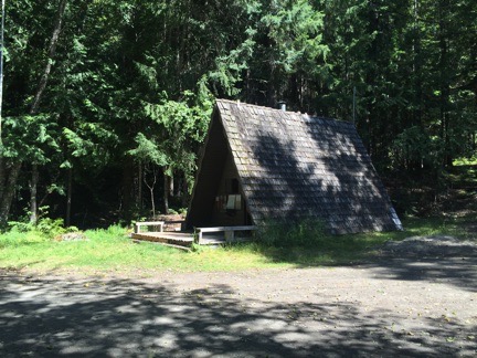
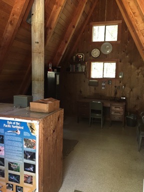
The ranger station at Hozomeen is a cute little a-frame that looks as if it’s been there for 50 years or more.

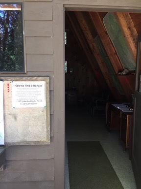
A little bit farther down the road was a cute little A-frame building that was clearly the ranger station. The flagpole was bare. The door was wide open. I parked and got out to see whether I had to check in or show ID or pay a fee. There was no one in the building, although it had clearly been set up for ranger business. The placed smelled old and musty, like my godfather Jackie’s basement antique shop. There were flyers — including one titled “Insects: Masters of Survival,” which I took, hoping I wouldn’t need to consult it — but no area maps. A sign outside was titled “How to Find a Ranger” and provided a list of places to look if you needed a ranger. Talk about loosey goosey.

Ranger Station Door Open Inside the Hozomeen Ranger Station
Left: The door to the ranger station stood wide open. Note sign titled “How to Find a Ranger.” Right: Inside the Hozomeen ranger station.

But let’s face it: we were in the middle of nowhere and the only road led north, back into Canada. It wasn’t as if this was a waypoint along a heavily trafficked route into Seattle. We were at the end of the road and beyond it were only bear-filled mountains. The only people coming to this place were people who wanted to be in this place — not somewhere beyond it. It wasn’t the kind of place you’d stumble into. The rangers likely realized that people who came here had done some sort of homework and likely wouldn’t need their help. Why sit in an office to greet the handful of people who might show up each day?

So I got back in the truck and continued down the road, trying to get a feel for the place and an idea of where I could camp for the night.

Three Sites at Hozomeen

Hozomeen lies at the far north end of Ross Lake, a 25-mile long, manmade lake along the Skagit River in the North Cascades. A mentioned above, it’s only accessible by car through Canada. It’s also the only place on the lake where where there are boat launches. So if you want to put a decent sized boat on the lake, you have to go to Canada to do it — even though less than 3 miles of the lake are within Canadian borders. There’s supposed to be good trout fishing in the lake, although limits are determined by whether you caught the fish in the U.S. or Canada.

Other than boating and fishing, there’s hiking. Hozomeen Campground was named for Hozomeen Mountain just to the east. A trail winds up from one of the camping areas to Hozomeen Lake. It was that trail that I was hoping to hike when I got here. But by the time I arrived in early afternoon, after being bumped around for an hour on the road from Hope, I wasn’t in the mood for a 7-mile round trip hike, the first mile or so of which was a steep climb. But I’m getting ahead of myself now.

A few hundred feet farther down the road was the first campground, Winnebago Flats. I’m thinking that’s more of a nickname than anything else. It was a mostly open area right on the water and was nearly full of RVers and tent campers baking in the sun. There were boats tied up at the docks and boat trailers parked here, there, and everywhere. Some kids and dogs, a generator running — definitely not the kind of quiet place I wanted to stay. I kept driving.

The road climbed a bit above the lake and entered the same dense woods I’d come to expect. Off to the right was the ranger housing — one of the places you might find a ranger — and beyond that, to the left, was a road marked Hozomeen Trailhead that climbed into the hillside. And beyond that, a campground loop. This one was just about deserted, with only three campers in 30+ sites. As I drove through, I liked what I saw. I picked a site on a hillside with views of the lake through the trees, backed my rig in, and got out to set up camp.

By “set up camp,” I really mean make lunch. I had the same thing I’d made the day before: grilled eggplant and goat brie on the bread I’d bought two days before. I finished up the brie but had no shortage of eggplant or bread. Penny sat in high alert while I made and ate my meal. I suspect she smelled the bears that were supposed to be in the area and was waiting for one to come bounding out of the woods.

After lunch, we followed the signs to the boat launch just down the road. I’d seen a ranger SUV head down there and figured I’d ask a few questions about the area. The road was longer than I expected and we reached the ranger boat dock first. That’s where the two rangers were. One was fiddling with the motor on a 20+ foot aluminum-hulled boat while the other sat on the dock waiting. Both wore uniforms and inflatable collar life jackets, like the ones I’d bought for overwater operations in my helicopter years ago.

I called out and the waiting ranger walked over. I asked him if there was a fee and whether I needed a backcountry permit. (No and no.) We talked about the bear situation (there was a resident bear), leaving fires unattended (a definite no-no), and leaving food out overnight (another no-no). He reminded me that Penny needed to be leashed at all times. We talked about the other campground and he mentioned that there were fewer bugs there because of the breezes — which is one reason it was so popular. The mosquitoes weren’t bad — yet — he assured me. (I’d already noticed them.) Then we talked about the condition of the road and the fact that bad weather in July had kept park attendance low, which kept the road from getting washboarded. We also talked about living and working in such a remote place and agreed that there were a lot worse places a ranger could be stationed.

By then, the other ranger had the engine running. I volunteered our services to help out on the boat if needed and we both laughed. Then we parted ways. As I headed back up the road, the boat roared out over the lake towards the opposite shore.

There’s a lot to be said about a career as a U.S. Park Ranger.

Back at the campsite, I took a nap. It seemed like something that had to be done.

Customs Cabin
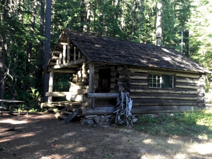
I read in one of the guide books that this was originally a customs cabin.

I woke up around four and felt that I really needed to do something. So Penny and I got into the truck and drove up to the Hozomeen Trailhead. It was a lot closer than I remembered it being — we could have walked. I parked by the old Customs Cabin there and got out to look around. The cabin was neat and clean inside, with two beds and a kitchen area. The padlock on the door wasn’t clasped shut, but I didn’t go in. I didn’t want to intrude on what might be someone’s living space. A creek roared by past the back of the cabin and there was a tall water tank nearby — likely the source of all the water in the park.

There were campsites nearby, too. One very close to the trailhead was large with what looked like a level place to park. There was a restroom nearby. No other campers. I peeked into the restroom and it was immaculately clean and odor-free — as if it were brand new.

Campsite Two
My second campsite for the day.

I got to thinking that this might be a better campsite. Clean restrooms, water right across the road, ranger housing just down the hill. I didn’t need any of these things, but they somehow figured into my calculations. Penny and I got back into the truck, drove it down to our first campsite, gathered together the few things I’d left out, and drove back to the new site on the hill. I backed in, maneuvering to get the Turtleback as level as possible, and parked. Then I unpacked those outdoor items and left them at the table.

I tried to sit for a while, but the mosquitoes were bugging me — literally, I guess. I put on some of the “all natural,” Deet-free bug repellant I’d bought in the Mazama Store a few days before. I didn’t have high hopes of it working — I’d read a review of bug repellants online recently and it rated the ones with Deet a lot higher than the others. But this one seemed to work. The mosquitoes stayed clear. And it didn’t smell bad, either.

There was a trail down to the road and feeling the need to take some kind of hike, I leashed up Penny and followed it. From there, we walked a short distance down the road before another trail led to the lake. That eventually put us right on the shore. It was after 5 PM at this point and still bright and sunny on the east shoreline. I quickly worked up a sweat and began wondering how that bug repellant would handle it.

Ross Lake Trail
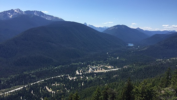
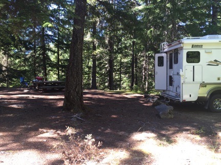
The trail through the woods eventually led to one right alongside the lake. You can see the campers at Winnebago Flats in the near distance.

The sunny campground was 3/4 of a mile from where I’d parked. As I walked through, I realized that the campers on the south end were the noisy groups while those on the north end were more laid back. I stopped and took photos from a few of the docks and chatted with a woman floating in an inner tube beside a boat with two barking dogs in it. (I’d left Penny on shore; she didn’t want to walk on the dock surface.) When I noticed the top of Hozomeen Peak to the east — which is impossible to see from the shore — she told me that in late afternoon as the sun was going down, it glowed.

That’s probably the seed that got me thinking about moving my campsite again. There was a campsite at the north end right beside a trailer parking spot. The lake would be right out my back door. It wasn’t a tough decision. When I told the folks two sites down that I was thinking of moving there, they offered to hold it for me while I fetched my rig. Thirty minutes later, I was backing into my third (and last) campsite for the day.

Campsite 3
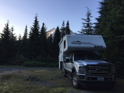
My third (and last) campsite for the day was small and not very private, but had nice views of the lake out the back windows.

Funny, but usually the problem is there not being enough good campsites to choose from. In this campground, there are too many.

Penny and I relaxed out behind the camper for a while. I sat in my new chair with my feet up on the picnic table bench. It was a quieter than I expected it to be. I’d made a good decision.

A ranger came by and invited me to attend a ranger program at the International Border Amphitheater at 8 PM. She wasn’t clear about how far away it was. I thought about walking over after dinner.

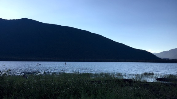
Later, I took out the grill again and cooked up a chicken thigh and some zucchini. We ate out at the picnic table, overlooking the lake. 8 PM came and went. My neighbors walked up to the presentation. I stayed at my site.

Stand Up Paddleboarders with Dogs
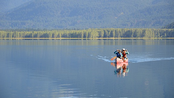
As I ate dinner, a pair of standup paddle boarders paddled down from Canada with their dogs. I shot this photo when they were on their way back after sunset.

When it got too chilly to sit outside, I went in and got to work on this blog post. I’m rather proud of the way I’ve been keeping up on this trip. It’s got me thinking that it is possible for me to get real writing work done when I travel.

My neighbors got home and started a campfire. But I was in bed asleep before they put it out.

Summer 2016 Road Trip, Day 5: Mount Baker to Chilliwack Lake

What a difference a day makes!

I slept like the dead. Again. Not a single vehicle drove by during the 12+ hours we were parked there.

The first thing I noticed when I woke up was that it was light out. The second thing was that the sky was clear. And then I remembered being half-awake in the middle of the night and looking through the sunroof to see stars.

Campsite Near Mt. Shuksan
Where did that mountain come from? It wasn’t there last night.

I looked out the back door. There was a snow-covered peak out there, just beyond the trees. I later realized that it was Mount Shuksan.

And then I realized that there was a pretty good chance I’d be able to see Mount Baker from Artist Point only a few miles away. In first light.

I sprung into action, getting the water boiling for my coffee while I got dressed. Penny didn’t stir. She probably thought I was going to spend some time writing, as I had every morning. But when I started putting my shoes on, she knew something was up. Only a few minutes later, the Turtleback was buttoned up and we were back in the truck with hot coffee and a piece of almond danish from Trader Joe’s, heading back up the mountain.

We passed a rig almost identical to mine parked between my campsite and the bee yard, right in the first spot I’d noticed on the way in.

Mount Baker, Revealed!

I stopped at Picture Lake again. The water was absolutely still, with a thin mist rising off the surface into the cool morning air. And there, to the southeast, just like it was supposed to be, was Mount Shuksan.

I parked and walked right to the spot where I knew the reflection would be. It was there. It was perfect. I snapped several shots from several different places with my cell phone and my Nikon. I recorded a video and shared it with Facebook friends. honestly wished they could all be with me. I’m such a sucker for reflection views.

At Picture Lake
Mount Shuksan reflected in Picture Lake.

Mount Baker
I finally got to see Mount Baker.

I continued up the road, all the way up to the Artist Point parking area. I got glimpses of Mount Baker along the way. I got out with my camera, planning to take a short walk to the viewpoint. I almost took my coffee with me. But I’m glad I didn’t because I wound up doing the entire Artist Point hike again. This time, I got to see the mountains around me. I was away from the car for more than an hour. Penny went back to sleep.

Mount Baker Reflection
The top of Mount Baker reflected in a snowmelt pond atop Artist Point.

When I got back to the parking area, I chatted with a ranger who was cleaning out the restrooms. I told her where I’d spent the night. She told me that if I’d gone all the way to the end of that road, the area opens up with incredible views of the mountains. Plenty of room to camp and turn around. Next time.

I moved the truck to a parking spot on the other side of the lot, backing it in so the back door faced right out to Mount Baker. There was another rig similar to mine parked nearby. While I got the water going for another cup of coffee, I chatted with the owner of the rig. He had a bicycle rack on the front of his truck and I wondered if it would be strong enough to support my new dirt bike. We got to talking about camping with our rigs and he told me that he and his wife had parked right there overnight. “There are no signs that say you can’t,” he pointed out. He was right. I could have stayed right there.

I had my second breakfast sitting out on my new chair, overlooking Mount Baker. Coffee, granola, greek yogurt, and the blueberries I’d picked over the weekend. Is it the view that made it taste extra special? Or the fact that I felt exhilarated after the previous day’s dismal weather doldrums?

After breakfast Penny and I loaded back up and headed down the mountain. I stopped again at Heather Meadows and took some photos of the area from alongside a small pond — more reflections, of course — and from the warming hut at the edge of the valley. I didn’t stay long. I was ready to move on.

Heather Meadows Reflection
Reflections at Heather Meadows. I did mention I was a sucker for reflections, didn’t I?

My next planned stop was Chilliwack Lake Provincial Park in British Columbia. Penny and I were going to Canada.

Good Day, Eh?

The trip down the mountain was uneventful. There was some road work that delayed us for about 20 minutes, but I filled the time catching up on the news and checking the weather and our route.

We’d cross the border at Sumas, WA near Abbotsford, BC. I had my passport card — a credit card sized passport good for crossing into Canada or Mexico by land — and documentation for Penny’s shots. I stopped to top off the tank with diesel in Sumas before getting on line to cross; I wasn’t sure if fuel prices would be higher or lower on the other side and figured I’d rather take care of it in the U.S. Then we drove up and waited on line.

At the Border
Waiting in line at the border.

When it was my turn, the border guy took my card and asked a lot of questions. Where did I live (Washington), what did I do for a living (helicopter pilot), was I coming to Canada to look for work (no), where was I going (some parks along the border), was I meeting anyone in Canada (no), had I ever been fingerprinted (yes), for what (concealed weapons permit), what kind of guns did I own (Beretta and shotgun), why do I have a Beretta (I got it when I lived in Arizona for protection; I live alone), did I have a gun with me (no), why not (I didn’t think it was allowed), did I have any ammo with me (no), how long had I had my truck and camper (December for truck, April for camper), was I leaving anything behind when I left Canada (no), was I selling anything in Canada (no), did I know everything on board my camper (yes), was I bringing any animals (my dog), did I have paperwork for vaccinations (yes). Those are just the ones I remember. It took a long while. I wonder whether it has anything to do with the last time I went to Vancouver, which was for my old work. I made the mistake of saying I was working and they almost didn’t let me in. Did they put a black mark next to my name? Who the hell knows?

He finally gave back my passport card and told me I could move on. “Enjoy your stay,” he said. I was just glad to have passed muster.

My cell phone worked fine in Canada — I’d turned on International roaming — and I asked Google to direct me to Chilliwack Lake. Then I made my way onto the Route 1 freeway (or whatever they call it in Canada) eastbound. It was amusing to hear Google give me directions in kilometers and meters instead of miles and feet. As if my brain had somehow switched to the metric system when I crossed the border. (I assure you, it did not.)

A while later, I was off the highway and on a back road through farmland. I stopped at a place called the Farm Store to buy some fresh corn. I wound up buying some excellent goat brie, balsamic sea salt, a loaf of bakery bread, and an ice cream cone. That’s when I discovered that (1) my credit card worked fine and (2) the $75 of Canadian money I had with me was “antique.” I had a paper “loonies” and two paper “toonies” — pardon me if I spelled either of those wrong — neither of which are printed anymore. The bills I had were also larger than the new money and the new money has a clear section across each bill. Canadians apparently hate it. A woman offered to buy my loonie and toonies; she said she had a friend whose grandson collects “old money.” I like encouraging kids to do something other than watch TV and play video games, so I traded her for a brand new $5 bill. A couple who observed the whole transaction wanted to know where I got that old Canadian money. “Canada,” I told them. “A long time ago.”

We got back on the road and continued east along the Chilliwack River, passing through a few towns along the way. Then the road settled into a relatively straight drive through a valley with occasional signs reporting how far away the park was. I put the truck in cruise control, following another truck with a pull trailer about a half mile ahead of me. The speed limit was 80 kph and I had to use my reading glasses to read the fine print on my speedometer to see what that was in mph (about 50).

At Chilliwack Lake

The pavement ended at Chilliwack Lake Provincial Park. I turned right into the campground after the trailer in front of me.

The campground was really a collection of smaller campgrounds, each with several loops. Like so many park campgrounds in the U.S., you could choose your own site. But unlike park campgrounds in the U.S., this one had an “attendant” who would come collect the fee: $22 or about $18 US.

Privacy While Camping

If you’re wondering how I measure privacy while I’m camping, it’s basically the same as I measure it at home. Can I get dressed/undressed without closing the blinds? Can I talk in a normal tone of voice without being heard? Can I relax or sleep without being woken by someone else’s conversation? Do the names of my neighbor’s misbehaved dogs and/or children remain unknown to me? If the answer to all of those questions is Yes, I have the privacy I want.

I equate staying in a campground to living in a subdivision. While it is possible to get the level of privacy I need, it’s not easy. It’s a lot easier to get privacy when you stay someplace more remote — which explains, in part, why I live on ten acres of land two miles down a gravel dead-end road.

I was hoping to get a site along the lake so I went there first. No luck. I pulled into a site near the lake, shut off the engine, and even got Penny out. But I looked at my surroundings — campers with kids (!) on either side of me and behind me with absolutely no privacy. I couldn’t stay there. To hell with the lake. I needed quiet and privacy.

Chilliwack Lake Campsite
Our campsite at Chilliwack Lake. On a whim, I put out the awnings for the first time. With a table close to the camper, this one would make a decent shelter, considering its size.

So we got back in and kept driving. I wound up in a heavily wooded site not far from the campground host. There was no one behind me, dense trees on the driver’s side, and enough trees for privacy on the passenger side. I backed my rig all the way in, right beside the picnic table and fire pit. All I saw out the back and back side windows were trees. That was as good as it was going to get.

I took out my portable grill and set it up on the picnic table, then went about making lunch. I put Penny was on her leash and left her car bed near the table. Then I sliced up some of the Japanese eggplant from my garden, cutting each one lengthwise. I brushed each cut side with olive oil mixed with Spike seasoning. (I prefer Mrs. Dash garlic flavor but hadn’t remembered to bring any.) I laid them on the grill, skin side down, and turned down the flame. With the lid closed, they baked to perfection. I had some of that goat brie and fresh bread, then scraped the meat of the eggplant off the skin and added it to the bread. Delicious.

The attendant came by; she was an older, heavyset woman who wanted to make sure I wasn’t staying more than one night because the site was reserved for the weekend. When I assured her I was just there for the night, she wrote up a receipt and parking pass and I paid her with $25 in Canadian bills, getting two large coins as change. She also gave me a map of the area, which I sorely needed if I wanted to find the hiking trails I knew were nearby.

I spent a little while working on a blog post about the previous day’s travels. I’d fallen asleep too early that night to get any writing done and had rushed out in the morning. If I didn’t catch up, I’d get too far behind to write up each day. As I mentioned in another blog post, I’m trying hard to get back into writing regularly, so it was important not to skip a day.

Lindeman Lake

The campground map included some information about local hikes. Post Creek to Lindeman Lake, which is the hike I’d seen when I did some research last week, was the one that interested me. According to the map, it was four kilometers with a 215 meter elevation gain. Rated moderate.

This is a family favorite and is known as the “Crown Jewel” of the park. This beautiful crystal clear lake offers many spots for summer campers to cool off or backcountry tenting pads.

Sold to the American who can’t convert meters to feet!

I had established the other day that I was good for an average elevation gain of 500 feet per mile. The hike up to Thunder Knob was just under 400 feet per mile and it was tough for me. The 4 km hike was 2-1/2 miles or 1-1/4 mile each way. That was fine. Short, even. But my brain didn’t process the elevation gain properly. It got stuck on 215 as feet, not meters. Turns out, 215 meters is 705 feet. That’s quite a climb in what turned out to be less than a mile.

Of course, I didn’t know that when I first started out. Family friendly hike! Rated moderate! Piece of cake.

Penny and I hiked to the trailhead along a very nice, mostly flat trail called the Trans-Canada Trail, which goes right through the campground. (It actually passed about 100 feet behind my campsite.) From there, we walked down the road to the parking area for the Lindeman Lake trailhead. At least part of this walk must have counted toward that 4 km because a sign at the trailhead said it was 3.4 km round trip to the lake.

We started off through the woods alongside Post Creek. It was very pleasant.

Hill Climb to Lindeman Lake
A typical portion of the trail to Lindeman Lake. This family was in front of me for about half the hike. I caught up several times and finally passed them about 1/4 mile from the lake.

Until it narrowed to a dirt path and started to climb. Steeply. Up a boulder- and log-strewn hillside.

There were red reflective markers nailed to trees along the way. They were necessary. Without them, people would not have been able to stay on the trail. It was basically a scrambling hill climb.

For almost a whole mile.

I actually did remarkably well. I look back on my physical condition five years ago, before I lost all that weight, when I spent most of my time sitting around, waiting for something — anything — to happen. (My life was pretty dull in those days.) There’s no way I could have done this hike back then. It would have killed me. But now, although I still don’t do uphill climbs very quickly, I have the energy to do it. I even passed some people on the way up. (Okay, so it was a family with four kids under the age of five and an older woman walking with a cane.)

It was hard, sweaty work, but it was still enjoyable. Why? Because it was in the woods and it was cool and there was the constant sound of running water nearby. And the smell of the woods and fresh running water. And the people were so friendly. And the lake at the end of the hike was everything the map blurb had promised.

Lindeman Lake Pano
A panoramic shot of Lindeman Lake, taken from the beach near the campsites.

Lindeman Lake
Like most lakes in the Pacific Northwest, this one had a logjam at its outlet. Post Creek flowed from here past the trail we took to the lake.

It was a beautiful lake. Long and narrow in a valley surrounded by trees and rockslides and cliffs. There were wooden tent platforms built in groups nearby. Camping lakeside here would be amazing. Once you got all the way up there with a pack on your back.

I didn’t go swimming, but one of two guys who arrived right after me did go in. He said it wasn’t that cold as he got started but then made that noise people make when they get into very cold water when he popped up after fully submerging. He didn’t stay in very long.

Penny and I hung out up there for about 20 minutes. Then we headed back. I motored. I always do downhill. It’s that gravity assist. I did enjoy the flat, wide trail for the last 3/4 mile of the hike.

Back at the campsite, I wasted no time getting into the shower. There’s nothing that feels better than a nice warm shower right after a hot, sweaty hike. And clean clothes. Also good.

Dinner and a Blog Post or Two

I spent another hour or so out at the picnic table, finishing up the blog post I’d started before heading out on the hike. Then, as it started to cool down, I retreated indoors with Penny, heated up some leftovers for dinner, and kept writing. I wrote up most of the day by the time the sun had set.

Ibuprofen. For the first time on this trip, it was absolutely required. My legs are very sore.

Summer 2016 Road Trip, Day 4: Baker Lake to Mount Baker

Making it up as I go along.

It was raining when I fell asleep but had stopped by the time I woke up at first light. The trees dripped steadily on the roof of the Turtleback, reminding me just how wet it was outside, even if it wasn’t raining.

Overnight, not a single vehicle had driven by.

I made coffee and finished up the previous day’s blog post by adding photos. Penny woke up and I let her out. When she came back in, she went right back to bed. It was that kind of day.

The Road to Larrabee State Park

Baker Lake
It was starting out to be another dreary day at Baker Lake. This view looks south down the lake.

By 8 AM, we were back on the road, heading south along the lake. It was a dreary day, with low clouds and not a single ray of sunshine. But the big surprise was the number of boats on the north end of the lake: dozens of them. There must be some serious fishing out there to get so many guys out on boats in that weather so early in the morning.

On the road down to Route 20 — Route 11, not the “shortcut” I’d taken the day before — I found the park I should have spent the night in: a tiny county park about 5 miles up the road on a small lake. It was nearly deserted with plenty of lakeside spots for only $5/night. Of course, that’s $5 more than I paid to park where I’d spent the night, but at least I would have been closer to my destination on that cloudy morning. And I think it was worth it.

I had three destinations that day, all in Bellingham: Trader Joe’s, REI, and Larrabee State Park, where I expected to spend the night. Common sense would dictate that I should make the two retail stops before the overnight stop, but I wanted to check out the campground before I committed to it. So I told Google to direct me there and it did, guiding me on Route 20 out of the foothills and into the farmland west of the Cascades. We passed over I-5 and hopped on Chuckanut Road, a narrow, winding road that eventually followed the shoreline north, with views of the San Juan Islands in the misty fog. It would have been a great road on a motorcycle, but in a 1-ton pickup with a full-sized camper on top, not so much.

I eventually reached the campground at Larrabee State park and turned in. The pay station was closed — it wasn’t even 10 AM yet — and instructions said to choose a site. There was a list of available sites and a map. I found a few that might work for me and drove in to check them out.

The campground wasn’t anything like I’d expected. It was densely wooded with narrow winding roads that I sometimes thought I wouldn’t fit through. The sites were relatively close together so there was no privacy. But that was sort of moot because it didn’t look like any of the sites on my list were large enough to get my truck into. The RV parking area was the kind of parking lot style “campsites” I abhor, although I admit they did have trees and shade. There were kids all over the place, mostly on bicycles and all loud. There was no sign of the coast or a beach or the tidal pools I’d hoped to explore — apparently you had to drive or hike down to the water. The train noise warning sound was a bit of a put off, too. When I had to back out of a road because it didn’t look as if I’d make a sharp turn up ahead, I decided the campground wasn’t for me.

I stopped in the parking lot to access the Internet. I uploaded my track log and blog post from the day before. I studied my maps, looking for a place to go. Mount Baker had been tempting me — would I find a place to spend the night up there? Would it be worth the drive? Since I had all day, I figured it was worth a try.

I used Google Maps to find the closest REI and continued on my way.

Shopping

REI was only 5 miles away — and on my way to both Trader Joe’s and the road to Mount Baker. I was looking for a lightweight, streamlined kayak that would be easy to take with me when I went out with the Turtleback. The two Costco kayaks I had were beginner’s kayaks I’d bought cheap because I didn’t know how much I’d like paddling. Turns out, I like it a lot. And with the number of lakes I expected to visit on this trip, it sure would be nice to have one with me.

But the REI in Bellingham doesn’t have a big selection of kayaks. I was referred to their website or their Seattle store — neither of which would help me that day. On my way out, I looked at an “adventure” map of the west side of Canada, decided it wasn’t detailed enough, and left empty handed.

Not so at Trader Joe’s, which was just two miles away. I picked up all the things I had on my list for a Trader Joe’s run — and a few more. The cashier and I got to talking about the weather, which was really getting me down. She said she loved it cloudy like that. I guess it’s a good thing she lives on that side of the mountains. More than 24 hours of clouds and rain had been more than enough for me.

The Road to Mount Baker

Google guided me to route 542, the scenic road to the Mount Baker recreation area. Well, the only road to Mount Baker. It left the semi-urban area of Bellingham quickly and passed into farmland. I learned that blueberries are a big crop in that area.

At Maple Falls, I turned toward Silver Lake, where there was supposed to be a campground with a dump station. That campground was my plan B (or is it C?) if I couldn’t find someplace to spend the night at Mount Baker. It was a huge campground with more narrow, winding, wooded roads and tiny campsites. Lots of availability and I could squeeze my truck into any of them. I stopped at the dump station on the way out and emptied my two holding tanks. Although I could have taken on some fresh water, I still had half a tank and didn’t feel like pulling out the hose.

Back to Route 542. The weather was still dismal, with patches of misty rain. The forecast had claimed it would clear up, but Mother Nature wasn’t listening to the forecast.

Wanting a hot meal, I stopped at a restaurant in Glacier for lunch, Graham’s. It looked pretty trendy from outside, but wasn’t the least bit trendy inside. It was just old and dressed up. The restrooms were weird with a big shared room that had a sink and two tiny toilet rooms. Whatever. When I’m camping, I never knock a flush toilet and hot water to wash my hands. I ordered the BBQ meat loaf sandwich, requesting the BBQ sauce on the side. It was amazingly delicious. Seriously: if I could make meat loaf that good, I’d have it all the time. Bacon, onions, provolone, soft fresh roll. Perfect. Wish I could say the same for the wine; it was a local barbera that was simply undrinkable. I tried and failed several times.

Back at the truck, Penny got my leftover meatloaf and seemed pretty happy about that. She’s a finicky eater, especially when we’re on the road, and I’m starting to think that I might have to start cooking for her.

Nooksack Falls
One of the few possible views of Nooksack Falls, which was crammed into a canyon with sheer rock wall sides.

Wooden Pipe
A wooden section of the diversion pipe at Nooksack Falls. You can’t tell from the photo, but the pipe is six feet in diameter.

We continued on our way, making one more stop before the end of the road: Nooksack Falls. This was an interesting waterfall on the Nooksack River, right where it meets with Wells Creek. There are fences that make it very difficult to get close to the falls and a warning sign that actually lists the names, ages, and dates of the people who were killed there within the past 30 years, including the unborn child of one of the victims who happened to be pregnant. (Talk about a downer!) But the fences were low enough to get photos and a good look. The site had been developed for a hydroelectric project downstream and some of the diversion pipe — which still has water running through it — runs through the site. It was kind of interesting in a weird sort of way — especially since a portion of the original wooden pipe was still there. It would have been a nice picnic stop if I needed one. The power plant was destroyed some years ago in a fire, so there was nothing of that to see.

We continued along Route 542, into the forest. Soon the road climbed steeply upward, with numerous tight curves and, later, switchbacks. If there were viewpoints, I didn’t notice them — all I could see where tree-covered hillsides climbing up into the clouds. The rain had stopped, but it showed no sign of clearing up.

I passed signs for the ski area and saw numerous buildings and ski lifts, all of which were closed. The road split into two one-way roads and wound around a small lake called Picture Lake. I got out to take some pictures (apparently, with my Nikon because I can’t find them on my phone) and wound up walking around the whole lake with Penny. Some signs along the way informed me that the lake was popular with photographers for the reflections of Mount Suksan to the southeast. I looked but could only see a mountain with snow climbing into the clouds.

Road to Artist Point
The road to Artist Point, shot from the Artist Point Trail on a less than perfect day.

I drove past the parking area for Heather Meadows, figuring that I might as well take the road to the end, which was just a few miles farther. It got very steep on this last part, with tight switchbacks. It ended abruptly at the parking area for Artist Point, which had about 30 cars in it. From this point, hikers could get on several different trailheads. The one that interested me was the one to Artist Point, mostly because it was short. I grabbed my camera, cracked the windows in the truck, and set out on a hike, leaving Penny behind.

Not Mount Baker
Mountain? There’s no mountain here.

I thought I’d be gone for just a short while, but it was at least an hour. Based on several signs along the way, I assumed I’d be able to see Mount Baker to the southwest if it was clear enough to see. It wasn’t. I could see the base of the mountain and some snow but the top half was completely obscured. I hiked the trail anyway, optimistically believing the weather forecast that said it would clear. It didn’t. I had a nice walk that included some photography and a thoughtful moment alongside a snowmelt creek. I reached several view points where I should have seen the mountain, but I didn’t. Instead, visibility got worse. I headed back, stopping to chat with a man who pointed out a grouse and two chicks. By the time I got back to the truck, visibility was down to less than 300 feet in the parking lot, which was now mostly empty.

We headed back down the road, this time stopping at Heather Meadows. The Fire and Ice Trail there was another easy one — a loop of about a mile. Although I didn’t plan on doing the whole thing, I did. Again, I left Penny behind. Again, the clouds obscured any mountain vistas. But I did get down to a large snowmelt creek that cut through a rocky, hilly meadow. It was the sound of this creek that filled the valley and could be heard all the way back up in the parking area.

Fire and Ice Trail
Along the Fire and Ice Trail. This photo makes it look as if it were cold out. It wasn’t — it was probably in the 60s. Just low overcast and dreary.

Looking for a Campsite

By this time, it was after 6 PM and I needed to find a place to spend the night. Part of me wanted to stay nearby just in case the weather cleared. If views of the mountains were possible in the morning, I could come back. But I didn’t want to drive all the way back from one of the campgrounds far below.

I remembered a turn onto a gravel road that I’d passed just below the ski resort. I found it on my map: White Salmon Road, FR 3075. It looked like it descended on steep terrain with three switchbacks before dead-ending. It couldn’t be more than two or three miles long. Maybe there would be a spot along the road where I could spend the night?

Nothing ventured, nothing gained. Ten minutes later, I made the turn and was heading down a narrow road through the forest.

Bee Yard Near Mount Baker
Why yes, there is a bee yard alongside the road near the Mount Baker Ski Resort.

I was very surprised to see a bee yard set up alongside the road. There were about 30 beehives there surrounded by an electric fence wire with a solar panel to keep it charged. (The fence was to keep out wildlife, especially bears, not people.)

I kept going. About a half mile down was a spot wide enough for me to pull over, but I really didn’t like the looks of it — too close to the road. I had no idea how much the road was used and didn’t want vehicles driving right past me.

I kept going. I started thinking about how remote it was. How unlikely it would be to get help if I needed it when I was so far from the main road. How long a walk it would be if something happened to the truck.

Just when I was ready to turn around, I found a campsite on the right side of the road. Slightly raised off the road, it was a clearing with three routes in/out. There was even a sad little fire pit in it.

Cell Tower
I had a 5-bar LTE cell connection when I shot this photo through the windshield of my truck. I wound up camping within 2 miles of here.

But do you want to know what sold me on it as a place to spend the night? I had a 2-bar LTE signal on my cell phone, probably from the cell phone facility I’d passed back up near the ski resort.

I turned the truck around so I was facing back down the road and my slide would be open away from the road. I maneuvered the truck into position in the site so it was relatively level. And then I killed the engine. We’d landed for the night.

Penny had no interest in walking around outside; she looked decidedly spooked. I suspect that she smelled some of the wildlife — maybe even a bear. So I locked the truck for the night and we went into the Turtleback. I had the door open for a while, but it was downright chilly so I closed it.

Believe it or not, I was still full from that meatloaf sandwich at lunch. I fed Penny some dog food, which she turned her nose up at. So I put her up on the bed while I read for a while, catching up on the antics of a certain presidential candidate who has turned election season into a surreal farce of epic proportions. I also checked in on Twitter and Facebook and peeked at my email. Part of me was glad to be on the grid while another part kind of wished I wasn’t. I liked not wasting time on social networks.

By 8:30, I was up on my bed, doing a crossword puzzle. By 9:30, I was asleep.

Summer 2016 Road Trip, Day 3: Colonial Creek to Baker Lake

A tale of two parks.

It began raining very early in the morning, maybe around 3:30. I was wakened by the first drops — my years as a cherry drying pilot have fine-tuned my senses to react to the sound of rain overnight. At first, I thought the sound was caused by tiny pine cones hitting the top of the Turtleback. Click, click, click. I could count the impacts if I wanted to. It was only when they were falling too frequently to count that I realized it might be rain. At first, I couldn’t believe it — after all, the day before had been perfectly cloudless day nearly all day. I looked up through the clear plastic sunroof over the bed, trying to see stars. When I couldn’t, I knew it was rain.

It might be my years of living in Arizona followed immediately by years of living on the desert side of the Cascade Mountains in Washington that make me forget that it sometimes rains when you don’t want it to. Yes, we had a rainy cherry season at home this summer: more than a dozen days with rain in the 10 weeks I was on call. But the weather for the week before my departure had been drier than dry — normal, in fact. The grass that had managed to stay green since spring was finally turning to gold, the wildflowers were withering, the blackcap raspberries I’d planted in the spring needed watering almost every day. Surely it wouldn’t be raining anytime soon. Especially not on my vacation.

But there it was: a heavy shower in the campground. The sound of the rain on my roof and in the trees almost drowned out the sound of the rushing water in nearby Colonial Creek. Almost.

Even after the rain stopped about fifteen minutes later, I couldn’t get back to sleep. I read for a while and did a crossword puzzle. Then I slipped out of bed, made a cup of coffee, and finished up the blog post I’d started the afternoon before. When it got light, I made myself a bowl of cereal with some of the blueberries I’d picked on Saturday morning and kept working. I pulled photos off my phone with a USB cable, not realizing that the cable was keeping the phone charged at the expense of my laptop’s battery. When I was done, my laptop’s battery was down to 24% power. That meant using the inverter to charge it so I could publish the post later when I was back in cell phone coverage later. The inverter has a noisy built-in fan and I only use it when I’m not around to listen to it.

Back on the bed, Penny got up out of her bed and stretched. I lifted her off the bed — it’s too high for her to jump down safely — and put her on the floor. It had drizzled a few times since I got up and it was raining then. She didn’t seem to mind too much when I let her out. She did her business under the truck — one of the benefits of being a tiny dog is that she can just walk under it. She came in when she was done and I gave her some breakfast while I got dressed.

It was a lazy morning, to be sure. None of my neighbors seemed to be awake. No noise from the RVers on either side of me. I could imagine the tent campers snug inside their nylon shelters, dreading breakfast on a wet picnic table. We’d had heavy rain one day on my last tent camping trip which, coincidentally, had been at the same campground the previous year. I’d been prepared with a tarp and ropes and we’d rigged up a good shelter over our table. So good, in fact, that we invited a family of four tent campers to join us under our shelter for dinner since they didn’t have a similar shelter at their site. But RV camping makes tarps and temporary shelters from the rain unnecessary. It makes the whole camping experience easier. Is it still camping, though? I guess that depends on how much of a purist you are.

I grabbed a nylon rain jacket and put it on over my long-sleeved shirt, just in case it started raining again. Then Penny and I took a walk to the garbage dumpster. I visited the very clean restroom I hadn’t noticed the day before and enjoyed the luxury of a real flush toilet. On the way back to our site, I noticed the family of tent campers at the creekside spot two spots down from us sitting dejectedly in folding chairs around a cold, wet fire pit. I hoped their day would get better.

After washing the dishes and stowing my loose belongings, I closed up the Turtleback and got into the truck with Penny. It was about 9 AM when we rolled out of the campground. We hadn’t used the picnic table or fire pit once.

On the Road Again

My plan had been to explore the area on the west side of Baker Lake, which was in the Baker-Snoqualmie National Forest. I was hoping for a lakeside campsite, possibly in one of the campgrounds I saw on my North Cascades area map. I wanted to get in a hike before the end of the day and thought I might find a good one along the way. Or possibly a good walk from my campsite once we’d parked. In any case, I was in no hurry to get there.

I did want to make at least one stop: the park Visitor Center in Newhalem, which was along the way. I knew from experience that my cell phone would work there. I wanted to check messages and texts, update my house-sitter and a friend with my current location, publish my blog post, and post my two hiking track logs with photos. And maybe check in on Facebook and Twitter. In other words, check in with the rest of the world.

I have to say this about being off the grid: On one hand, it’s wonderful to not have communication and social media distracting me and taking up so much of my time. But on the other hand, it sucks to not have access to basic information such as weather forecasts and maps. The weather had completely taken me by surprise, which would not have been the case if I’d had access to the Internet.

Along the way to Newhalem, I saw some of the damage wrought by the fires that had swept through the area after my camping trip last year. Thousands of tall fir trees standing dead, their needles burned off, skeletons of what they once were. There were dozens of patches like this along the mountainsides, climbing high into the low-hanging clouds. I wondered why I hadn’t noticed the extent of the damage the previous autumn when I was in the area for a mushroom course at the North Cascades Environmental Learning Center. Had I been too distracted by the autumn colors? Or had the weather that weekend been so much worse that I just couldn’t see the burned up trees? It had certainly rained very hard on our mushroom hunting day.

My phone pinged to life about a mile short of Newhalem. Text messages, social media notifications, missed call notifications. The usual. (My house-sitter texted to say that she couldn’t believe how many tomatoes and eggplants were in my garden.) Nothing pressing. But it did mean that I was back on the grid.

I parked in a regular spot near the Visitor’s Center in Newhalem. It was pretty much deserted at about 9:30 AM. I fiddled around with my devices, posting my track logs with photos from my phone first and then using my iPad as a hotspot for my laptop to publish my blog post. It sounds a lot more complex than it is. While the blog post and its photos were being uploaded, I used my phone to check Twitter and Facebook and reply to some comments there. Then I posted links to my track logs and new blog post. The whole chore took less than 15 minutes. When I was done, I closed up all my devices, put away my laptop and iPad, put my phone in my pocket, and went to see if I could find a decent map of British Columbia at the Visitor Center.

I was chatting with the ranger when my phone rang. Seriously: I would only be on the grid for about an hour but someone managed to catch me. It was a woman who wanted me to do helicopter rides at Quincy’s Farmer Appreciation Day in September. She needed details for an article in the newspaper. I answered her questions while I looked at the books offered for sale. When I hung up, I chose a small book about easy hikes in the North Cascades. (I later discovered that I had already done all or part of six of those hikes, including the two hikes I’d done the previous day.) I also bought a “2016 National Park Service Centennial” refrigerator magnet. And I got a free map of Washington State’s Scenic Byways. The ranger and I chatted briefly about the road to Baker Lake before I left.

I made a quick stop in the store across the street, looking for velcro, which they didn’t have. Then I was back in the truck with Penny, heading out of town.

Although Newhalem is still inside the park, it feels as if it’s outside. The road winds mostly down to the west from there, out of the mountains. I stopped briefly at the convenience store in Marblemount, still looking for velcro, and emerged with a small tube of Gorilla Glue, a pint of milk, and some Hostess Cupcakes. Then more winding, descending road. I was now farther west than I’d ever been on Route 20. But I hadn’t really missed much. Once I’d left the park, it was typical foothills driving on the west side of the Cascades: cloudy with rain showers through rural land with the occasional town. Seriously: does it ever not rain on that side of the mountains?

I took a detour off route 20 through the historic area of Concrete. This is a cute little town that might be (but probably isn’t) popular with tourists on weekends. I did find what I was looking for, though: a True Value hardware store. These small town hardware stores are really gems. They’re loaded to the gills with everything you might need to build, repair, or decorate your home. This one occupied two storefronts with an open area between them. Because my truck was protruding into the main road, I wasted no time getting someone to help me find what I needed: adhesive velcro and a outdoor folding chair. If I’d had more time, I would have wasted an hour in there and probably bought a lot more than I needed. There’s something about a good hardware store that I really like.

Back on the road, I almost missed the turn for Baker Lake. The narrow, winding road climbed up a steep hill with lots of 10 mph switchbacks. I had to take it slow and started wondering how long it would take to get to the lake. I hadn’t expected the road to be quite like that. But then it ended abruptly at the road I should have turned on: Baker Lake Road (Route 11). I’d unwittingly taken a “shortcut” that wasn’t very short.

On Baker Lake Road

Baker Lake Road was wider, better maintained, and straighter than the one I’d been on. It headed north, paralleling Lake Shannon and then Baker Lake. I passed the turnoff for Route 12, which led westward to the Mount Baker Recreation Area. Soon — very soon, it seemed to me — I was at the turnoff for the Upper Baker Dam, which created Baker Lake. I turned in to check it out.

About two miles down the road was a mostly vacant campground with parking lot like sites. Beyond that, a fork in the road with the right leading to the road over the dam and the left leading to the boat ramps. For reasons I still can’t determine, I went left. I wound up in a parking area full of boat trailers and fishermen taking their boats out of the water. It was busy; I guess Baker Lake is a real hit with fishermen. I noticed I had a cell signal there and consulted the map on my phone. I was exactly where thought I was. And I didn’t need to be there. So I turned around and retraced my route back to the main road.

Shadow of the Sentinals
The main features of the Shadow of the Sentinels Nature Trail were the old growth trees towering well over 100 feet into the sky.

Shadow of the Sentinels Nature Trail was my next stop — and not a moment too soon. Penny was eager to get out and run around. This is one of those stops built to help the casual tourist get in touch with nature — without much effort. It doesn’t matter if you’re young or old, fit or a couch potato, tuned in with the world or out of touch with reality. Who can’t take 20 minutes to walk on a boardwalk among old growth trees in a densely vegetated grove? The half-mile loop trail wound into the forest with plenty of interpretive signs along the way. The forest floor was absolutely carpeted with moss, fern, lichen, and countless kinds of shrubs. The trees grew straight up into the cloudy sky, draped with what looked like Spanish moss. If it weren’t for the boardwalk, the trail would likely get grown over weekly. And yes, a 680-year-old tree is very big. Think redwoods big.

There weren’t many people there, although one group was a family with two small, loud boys whose shouts seemed to echo throughout the forest, audible no matter how far away I was. Penny and I walked the trail quickly, more for the exercise and experience than to learn anything new from the interpretive signs. I would have stayed longer on a nicer day, especially if the loud kids weren’t around. As it was, I think I was more fascinated by that winding boardwalk than anything else.

Boardwalk Trail
To me, raised boardwalks like this one, forming a nearly a half mile long trail through the forest, are the real attractions of nature trails like Shadow of the Sentinels.

Back on the road, I skipped the turnoff for campgrounds at Horseshoe Cove and Bayview, preferring to go farther uptake. It wasn’t much of a drive. The map made everything look farther away than it was. I drove through Boulder Creek and Panorama Point campgrounds. They were similar: very small campsites nearly right on the road, some adjacent to the ones beside them. Very little privacy. Most had Reserved signs on them; it was a while before I realized that the dates were in the future and most of the empty sites were not reserved for that night.

It was around this time that I started getting a bad vibe about the area. I can’t really describe it. It kind of reminded me of old, off-season resorts in the Catskills: busy and popular at one time, but now neglected and decaying. This feeling would nag at me as I continued up the road, visiting one campground after another. It got especially strong when I drove through what my map referred to as Baker Lake Resort but the sign identified as Swift Creek Campground. It may have been a resort at one time, but now it was just a collection of campsites, a closed down store, and a boat ramp. In many of the campgrounds, there appeared to be squatters — people who had been living there for a long time with lots of junk spread out in their site. It was unclear whether these sites had a nightly fee or if a Northwest Forest Pass was sufficient. At one campground, a very nice site overlooking the water was being used as overflow parking with three cars in it — but no sign of camping. I felt almost as if I were intruding just by driving through.

I continued up the road. Past a certain point, people were camping alongside the road. They’d park in narrow turnouts and set up their tents between the road and the lake. Some of these sites were quite spacious — but they were still right next to the road.

Free Camping

Camping is pretty much legal anywhere in National Forest or BLM land where it isn’t prohibited. In other words, if you find a nice parking spot down a side road in a National Forest and there isn’t a No Camping sign around, you can camp there. Campfires may or may not be allowed depending on local burn bans. Firewood collection might not be allowed; again, it depends on local rules. There likely won’t be any facilities and you’ll have to pack out your trash. Although there’s often a 14-day limit, it’s usually free.

That’s how I camped for free on my first night of this trip. I also did it in for weeks on BLM land along the Colorado River in Arizona with some friends this past winter. There’s nothing nicer than free, private waterfront living.

I kept going past the Pavement Ends sign and continued on gravel. No big deal for me and my big 4WD high clearance truck, but I assumed it would weed out a lot of city dwellers who liked to keep their cars clean. (Although I suspect it’s hard to keep a car clean in a place where it seems to rain all the time.) There were still people camped along the road. In one place, there were two empty boat trailers parallel parked alongside the road; I still can’t figure out how they got their boats off, through the narrow stretch of woods, and into the water.

As I neared the top end of the lake and passed the Road Narrows sign, I realized that I was probably not going to find a campground site I liked. I started looking at options along the road. Near the end, I found a nice turnout that had obviously been used for camping. Although large rocks prevented me from driving all the way in, there was plenty of room to back in far enough off the road. Beyond the rocks was a trail leading down to the water. But it wasn’t the lake anymore; it was the rocky delta of Baker River. I got back into the truck and kept driving. A half mile farther, the road ended at a trailhead parking lot for the Baker River Trail — coincidentally one of the trails in the book I’d bought that morning. People were parked along the edge of the parking area and tents were set up in the woods nearby. A makeshift campground.

Night 3 Parking
Here’s where I parked for the third night of our trip. It was far enough off the road, surrounded by drippy trees with the river a few hundred feet away out back.

I backed the Turtleback in beside another truck camper, thinking I might spend the night right there. But when I got out to take a look around, I got those bad vibes again. This is not where I wanted to spend the night. Who knows what these people might be like? Would they be crazy drunks who get loud after dark? Would their dogs be barking on and off all night, triggering Penny to do the same? Did I really want to be parked right next to another RVer and have to lower my blinds for privacy? Suddenly, that spot back up the road looked really good. So I got into the truck, drove back to it, and backed the truck in as far as I could go.

Not what I’d envisioned for the night, but it would do.

Lunch and a Hike

By this time, it was after noon and I was hungry. I heated up some leftover steak and ate it with a salad that included the last of the tiny tomatoes from my garden. I drizzled the steak juices over some kibbles for Penny.

Then we headed out for our afternoon hike. I figured we’d follow the short of the river back up to the trailhead and then follow the trail for a mile or two. My goal was to make sure I got my 10,000 steps a day on this trip and I wasn’t even halfway there. Three or four miles would be enough.

The shore of the river was rocky, with smooth river stones carved by glaciers far upstream and carried down by spring floods. Huge, old growth trees, torn out by wind and water, lay scattered like so many matchsticks on the rocks. The river’s channels wound through the delta, its water rich with glacial flour that gave it a milky color. The sound of the rushing water competed with the sound of the drizzle on the hood of my nylon rain jacket.

Baker River
Looking down Baker River, from the shore right behind my campsite. Every once in a while, the sky would brighten, leading me to believe that it might clear up, but it never did.

It wasn’t an easy walk. The rocks were large and required carefully footing to navigate without mishap. The logs often blocked the most direct route, requiring me to go around or over them. Penny accompanied me, sometimes in front of me, sometimes lagging behind to sniff at a stump or clump of weeds.

We reached the trailhead parking lot/camp area a while later. I was surprised to see that we’d already walked almost three quarters of a mile.

We passed a few of the people there. None of them acknowledged us. One guy walked right past us without so much as a nod. Unfriendly. That vibe again. I was glad we weren’t camping among them.

We got on the trail and headed north. It was a very wide, very smooth, very level trail. Easy. I set a brisk pace. My goal was to walk a total of two miles — as measured by the Gaia GPS app on my phone — and then turn around and walk back, taking the road from the trailhead to our camp. A brisk pace would make it a good workout and hopefully get us back before the rain soaked us.

It was a nice walk through old grove forest. Every once in a while, I’d notice a particularly huge tree or interesting bit of vegetation. There were few wildflowers, but I think that’s mostly because the forest floor probably got very little sunlight.

Bridge Across Baker River
This sturdy wood and steel suspension bridge spans Baker River for hikers and horseback riders. This is our tax dollars and park fees at work, folks.

After a while, I caught sight of a bridge across the river. It was a wood and steel suspension bridge, designed for foot and horse traffic. The trail spilt here. The Baker River Trail continued north as a narrow path for hikers only. The Baker Lake Trail turned right over the bridge and continued south down the other side of the river back to the lake. I chose the wider trail, mostly because I wanted to be able to keep an eye on Penny, who is easily hidden by tall brush alongside narrow trails, and to keep my jeans dry.

The Bridge over Baker Lake
I really admire the structures like this, especially when they’re so well-built and out in the middle of nowhere.

As we walked over the bridge, I took a moment to look at the solar panels attached to it, wondering what they could be powering. The answer was on the other side: a USGS flood gauging system that likely broadcast information to a base somewhere.

Blum Creek
Blum Creek, near where it enters Baker River. You might think that all this flowing water is from the rain. It isn’t. This is glacial runoff.

We crossed another small footbridge, this one over Blum Creek, and continued through the woods. The rain started to pick up, but, at the same time, my quick pace was causing me to work up a sweat under my layers of clothing: long sleeved shirt, fleece hoodie, nylon rain jacket. I stopped to pull off the hoodie and leave the rain jacket draped over my shoulders. We’d walked just short of two miles when I’d had enough. We turned around and went back the way we came.

It was a good thing we did. The rain started coming down harder. Back on our side of the river, we passed a family hiking north; I figured they had to be from Seattle and used to the rain.

I put the leash back on Penny as we finished the hike along the road from the trailhead parking lot to our camp. Although she’s usually pretty good around cars, I didn’t know how people would be driving.

It was good to be back in the Turtleback.

Repairs

After stripping off my wet clothes and putting on some dry ones, I did a few repair chores.

The first was the velcro. Apparently one of the three pilots who had stayed in the Turtleback during cherry season had snapped off the plastic latch that holds the medicine cabinet door closed. The result: the door swings open and closed during travel, spilling medicine cabinet contents all over the bathroom. Not acceptable. I’d found a temporary remedy with a bungee cord, but it was a royal pain in the butt to deal with.

I decided to try velcro: one small piece in the top corner of the door. I prepped the areas by cleaning and drying them thoroughly and then sticking the stuff on. The instructions say maximum adhesive strength is in 24 hours, so I left the door open for now and will close it before moving on.

The second was the latch to the cabinet under the sink. All of the cabinets have push-latches that keep the doors closed until the button on the latch is pushed. But the one under the sink doesn’t catch properly. The result: the door swings open and closed during travel. Although nothing falls out, it bugged me that the door wouldn’t stay closed. Surely there was something I could do.

I compared the door latch on that door with another cabinet door and discovered that its position wasn’t quite right. I used a screwdriver to loosen the latch, shifted it back a bit, and tightened it back up. Voila! The door works perfectly.

The Turtleback needs one more repair that’ll require parts from Lance: the latches that hold sunroof over the bed in the full down position broke off. I think this is because they’re plastic and have spent a lot of time in the sun. I’ll have to order and install new latches. Until then, I’ve discovered that I can keep the sunroof in the slightly open position while driving; not locking it in that position causes it to swing wide open, which isn’t a good idea in rainy weather or at high speeds. When I’m parked, it’ll stay full down, even without the latches.

I’d like to make a few improvements, too. For example, there are key hooks over the door; the previous owner likely put them there. Trouble is, you need to be in the camper to reach them. In the Mobile Mansion, I’d mounted the key hooks near the floor at the door. This made them easy to reach from inside or outside with the door open. Instead of key hooks up there, I’d like to put a shelf. I already had a charging station for my phone installed on the side of the cabinet there, which is close to the stereo so I can plug in my phone for music while charging it. It would be nice to lay the phone and other things, like my sunglasses and wallet, on a shelf up there, out of the way.

And hooks. I need hooks in the bathroom to hang items I want to dry.

I’m still debating whether to remove the stove lid and use my big cutting board there as a lid and additional counter space. The stove lid in the Mobile Mansion broke off within a few months of buying it and I never missed it. The cutting board has feet that fit solidly over the stove grating. I can stand it up behind the stove when not in motion. I think it all depends on whether I can remove the stove lid neatly, without breaking it. I’ve already removed a cabinet door in the sleeping area because the mattress I added makes the bed too tall to get the door open.

These are all things that get hashed out when an RV is in use. I like to customize my space, especially when I know I might spend months traveling with it, as I hope to this winter.

R and R

When I was done with the repairs, I relaxed at the table with a crossword puzzle. I’m just starting to figure out how to get comfortable in the Turtleback and I admit that I sorely miss the Mobile Mansion’s La-Z-Boys. It it hadn’t been so nasty out, I probably would have tried out my new chair, possibly set up along the river bank.

Inside the Turtleback
A panoramic view of the back end of the Turtleback from my seat at the table. We were surrounded by lush, green forest, dripping from the rain. You can see the trail down to the river on the right side of this photo.

Penny wanted to nap, so I lifted her up onto the bed and she got into her bed. I thought she had the right idea and climbed up beside her. Soon, I was drifting off to sleep. When it got chilly, I went down to fetch a blanket. Then I was out like a light.

Until 8:30 PM.

Sheesh. I couldn’t even use a long hike as an excuse for such a long nap.

Miraculously, I wasn’t hungry when I woke up. That didn’t stop me from eating the pudding I’d made that morning and left in the fridge for dessert.

It was nearly dark when I let Penny out to do her business for the last time that evening. I gave her some dog food, which she turned her nose up at. Then I put her back on the bed and she went back to sleep.

I stayed up at the table for three hours writing this blog post. Outside, it rained hard for a while. I cracked one of the windows open so I could hear the sound of the river not far away.

I decided I wanted an early start in the morning. I’d be heading back into civilization, staying at a State Park campground on the coast after making stops at Trader Joe’s and a supermarket. I might even have a full hookup Wednesday night.

I just hope it stops raining.

It was nearly midnight when I went to bed. When I turned off the light, it was pitch black dark — darker than I’ve been in for a long time. And other than the faint sound of the river out back and the dripping of the trees, it was dead quiet.

A Weekstart Trip with the Turtleback

Or 28 hours off-the-grid.

I brought the Turtleback home on Wednesday and left it on my truck on purpose. I wanted to take it out for a short trip before I put it away.

I wanted to test it out in real off-the-grid conditions. I wanted to see how comfortable it was, how well I slept in it, how hot the water got, how loud the heater was. I wanted to cook a meal in it, wash dishes in its kitchen sink, and use the toilet in the middle of the night. I wanted to take it on a narrow gravel road and squeeze into a parking space I couldn’t dream of fitting into with its predecessor.

I’d do it locally — or relatively so. There’s a campground called Rock Island about 17 miles up Icicle Creek near Leavenworth Washington. The total driving distance is about 75 miles. One of my favorite trails, the Icicle Gorge Loop Trail, runs right past it. I thought I’d get a campsite, set up camp, and do the loop trail.

The campground page on the USFS website said Rock Island Campground got “heavy use.” I hate crowds so I didn’t want to do the trip on a weekend. I figured I’d do it on a “weekstart.” (If Friday through Sunday is the weekend, then Sunday through Tuesday should be the weekstart, no?) The way I saw it, most people left the campground on Sunday; I’d pull in on Sunday evening, get a good site, and avoid the crowds.

Heading Out

Of course, things don’t always turn out the way you want them to. I lost about two hours of my Sunday to a bee swarm call that was a total bust. (Don’t ask.) Then I spend another 30 minutes looking at new grills. By the time I got back home to pack, it was well after 4 PM. There was no way I’d have time to shower, pack, and head out before the friendly propane suppliers closed. I’d leave the first thing in the morning instead.

I was ready to go by 7:30 AM with the refrigerator packed, clothes and dog supplies loaded, and water tank topped off. I got a mile from my home before I remembered that I needed to harvest some broccoli that would flower if I didn’t and that I’d forgotten my Nikon. Twenty minutes later, I was headed out again.

I stopped at Ag Supply on North Wenatchee Avenue for propane. I asked for a “strong guy” to help me. Lots of places won’t load full propane bottles back into your truck. They’re not required to. But friendly places do. And the main drawback to the Turtleback is that the two 7-gallon propane tanks are in a cabinet about level with my head. Getting them down when they’re empty will be easy. Getting them back up there, not so much. And I had no idea how much propane was in them. I didn’t want to run out on my maiden voyage.

The kid who helped me used my stepladder to get them down and put them back. They were each about 1/2 full. I like to run one tank empty before switching to the other and refilling the empty so I always know I’ve got a full tank. These tanks have fancy gauges that I didn’t think worked. They do. They just read a little low.

The next stop was in Leavenworth: Safeway. I needed a gallon bottle of water — I don’t drink what comes out of an RV’s tank. (Ick.) And some orange juice. And an almond croissant. And a veggie platter to snack on. And bacon (which I forgot).

Once the groceries were loaded, Penny and I continued on our way with me munching a croissant. And then a donut. We drove through town and turned left onto Icicle Road. Soon we were winding up the canyon beside Icicle Creek, which was rushing madly with spring snow melt. Few cars were on the road — it wasn’t even 10 AM on that Monday morning. Pavement turned to gravel and we kept going, passing one campground after another. It was when we got to Chatter Creek Campground’s turn that I saw a pickup truck at the campground entrance. A woman was out of the truck moving a ribbon that stretched across the entrance drive. I stopped my rig and called out to her: “Is the campground closed?”

She came over and we chatted. All the Campgrounds past Johnny Creek were closed. Some biologists were checking out trees. Bark beetle was an issue. Was Rock Island closed? Yes. I pointed out that the website didn’t say the campground was closed. She had nothing to say about that. I asked her if the ranger station up the road had more information and she told me that was closed, too. But there’s some distributed camping, she said in a sort of wink-wink-nod-nod-say-no-more kind of way.

“Yeah, I’ll just find one of those sites,” I said. “This is set up for off-the-grid camping.” I thanked her and shifted into gear.

She took a step back and said, “Nice rig.”

I laughed and thanked her.

I kept driving. I took it slow. The truck handles a bit differently with the Turtleback on it. Higher center of gravity, exaggerated bumps, lots of squeaking. One of the things I’ve learned over the past few years is patience. I’m seldom in a hurry to do anything. I think it’s got to do with my relaxed lifestyle. So when I want to drive slowly, I can.

I passed one of the Icicle Gorge Loop Trail trailheads and kept going. Then I reached Rock Island Campground. It had the same red ribbons tied across its access roads with signs that said, “Closed to Public Use.” I kept going.

I stopped for a while in a parking area where I’d gone mushrooming with a friend the previous fall. Penny and I got out for a short walk in the woods. It was wet — I think it had rained that morning — and there was some flooding down on the trail. We didn’t stay long. We didn’t see any mushrooms either. Seriously: what was I thinking? It was way too early in the season for chanterelles.

We continued down the gravel road. The only thing left was a horse loading area, a horse campground, and the Icicle Creek Trail Trailhead at the very end of the road. The horse campground was closed (of course) and a pretty good water flow crossed the road just past it. Although the ford had a concrete bottom, I didn’t see any reason to drive through. I couldn’t camp at the trailhead. So I turned around and started looking at some of the side roads I’d passed.

One of them about halfway back to Rock Island Campground looked pretty good — but narrow. I parked the truck on the side of the road and got out with Penny to scout it out. I’d lost my cell signal before the pavement ended and the last thing I wanted was to get stuck on some dirt road in the middle of nowhere. Better to look on foot than explore with the truck and Turtleback.

The road was narrow with scattered potholes, many of which were deep and full of running water. Branches came low over the road. The Turtleback is at least 12 feet tall and more than 8 feet wide — it would be pushing these branches aside as I drove. But there didn’t seem to be anyplace to drive to. One by one, we passed right turns that we either short or extremely narrow paths unsuitable for my rig. We kept walking. We’d gone about 1/3 mile when I saw it: the most amazing campsite I’d ever seen. Nearly level with a mix of sun and shade, a fire pit, logs to sit on, and Icicle Creek rushing past.

Not the best video in the world, but it gives you an idea of what the road was like. If you can, watch it fullscreen.

We went back to the truck and climbed on board. I used my phone to video our 4-minute drive back to the site. You can hear the truck and camper pushing through the branches. It sounds like I’m beating the crap out of my rig, but there wasn’t any damage.

I backed into the campsite and killed the engine. Icicle Creek was about 50 feet from the camper door. I could hear the water rushing — it was about the only thing I could hear. It sounded wonderful.

My Campsite
Here’s a panoramic view of the campsite with the Turtleback parked in it.

And, of course, we were the only ones around — possibly for miles.

Setting Up Camp

There wasn’t much to setting up camp. That’s the beauty of traveling with an RV. You park it, open a slide (if you have one), and you’re good to go.

In my case, there was a bit more work. Although I’d brought linens with me, I hadn’t made the bed. So I did that. I also stowed the few items of clothing I’d brought. And the medicine cabinet items I planned to leave in there.

I’d also brought along some MatchLight charcoal, scrap lumber, and newspaper, all in a box. I put those outside beside the fire pit, along with a new grill I’d bought for cooking over the fire. I wasn’t going to “cook” — I had some smoked ribs that needed sauce and grilling to finish up before they were ready to eat. I was going to reheat them there. The only other alternative for reheating them was the convection microwave and I had no desire to run the generator.

Penny on Guard
Penny on guard duty.

I should mention that while I was doing all this, Penny was sitting outside the camper door on high alert, shivering a bit in the cool air, watching the forest around us. She’s pretty funny sometimes. She’s incredibly brave for a small dog, always running far ahead on hikes and challenging other dogs that give her the weird eye. But there in the forest, in a place completely unfamiliar to her, she stuck close to home. I suspect it was because she couldn’t hear much above the sound of the rushing creek and she was likely smelling all kinds of wildlife that could include something as exotic as bears.

As I was finishing up, I started thinking about all the things I needed to set up a good camp. Some of the things were things I already had and could leave in the camper but had neglected to pack them: folding chairs, lantern, BBQ tongs, Dutch oven, steamer basket. Other things would have to be bought or otherwise acquired: battery monitor, stiff broom, outside door mat. Of course, I didn’t have a pen and paper to write these things down. So I fetched a pen from the truck and made lists on the back of the cardboard insert that had come with the BBQ grill. I added notebook w/pen to the bottom of the list. Duh.

I’d periodically add items to this list over the next 24 hours. And two more lists: things to fix/add (outdoor shower, DC outlet near stereo) and things to modify (bedroom closet, key hooks, mattress top).

The Hike

Penny and I went for a hike right from the campsite. There were narrow trails leading up and down Icicle Creek. I picked the one heading up and we started out.

Stream
Spring runoff had streams running all over the place.

We didn’t get far before our path was blocked by a rushing stream. I didn’t want to get my feet wet and there didn’t seem to be a way to cross. But Penny was already finding another trail. I followed her up the little creek into the woods. After a while, the path turned back toward the creek and another chance at crossing. It was wider there, with strategically placed logs that looked crossable. But there was a lot of water flowing and falling in would not be good for either one of us.

Log
Penny and I crossed the stream on this log. Her way was blocked by the log and branch lying across the larger log.

Still, before I could make a decision, Penny had already started across, jumping from one stone or patch of earth to another and pausing on a center island. I knew I could get at least that far so I followed. Before I could stop her, she began trotting down the log that went to the other side. Trouble was, there were other logs on top of that log and her way was blocked. So she tried to find another way. Worried that she’d misstep and fall into the rushing water, I inched my way across the log, stopping near where she’d found another island to stand on. I coaxed her into my grasp, picked her up, and tossed her the final four feet to the opposite shore. Then I followed, hoping we wouldn’t have to go back the same way.

Seriously, though: my dog is very brave.

Or maybe not. The trail was narrow as it wound through the woods. For a while, there were signs of horse traffic — after all, the horse trailer parking area was just up the main road. Then that disappeared as the trail got really narrow and the brush seemed to close in. Penny ran ahead, as she usually does. At one point, she stopped along the trail, sniffing the air. She growled and then barked. I looked and saw nothing.

But although my sense of smell is better than most people’s, it’s no match for a dog’s. She was smelling something I couldn’t and it was getting her riled up. What was it? Could it be a bear?

Yes, there are bears in the area. No, I’ve never seen one there. But one of the signs I’d seen earlier in the day was all about keeping a bear-safe campsite. And here we were, in a thick forest, and Penny was barking at something I couldn’t seen.

Talk about creeping me out.

I hustled her along the trail, eager to keep moving, trying to remember if I was supposed to be quiet or make a lot of noise if I encountered a bear.

Pacific Trillium, White Pacific Trillium, Pink
I did stay focused on the walk enough to take some photos of some of the flowers we saw along the way. These two look like two different colored versions of the same thing: Pacific Trillium. (Correct me if I’m wrong, please.)

After a while, the trail turned toward the road and dumped us in the horse trailer parking lot. We walked down the road as far as the ford, then turned around and followed it all the way back to the side road we’d turned down to camp. I’d had enough of the dense woods and Penny barking at things I couldn’t see.

Camp Trail
Here’s my track for the hike we took from camp. It was only 1.7 miles. You can find the stats and photos for this hike on the Gaia GPS website.

Relaxing

Penny in Bed
Of course I brought Penny’s bed with us.

I had a lunch of sardines with scallions on crackers — don’t knock it until you’ve tried it — and then stretched out on my bed with a book to relax. Penny couldn’t jump up on the bed so I had to lift her into place. She settled right down in her bed for a nap. Soon I was dozing off. (I’m still fighting a bit of a cold that I’ve had for over a month now and I get sleepy in the afternoon if I exert myself too much early in the day.) I found the sound of the creek soothing.

I dozed and read most of the afternoon. Outside, the sky changed from sunny to cloudy to sunny to cloudy more times than I could count. I was glad for the sun; the solar panels on the roof would keep the batteries charged. I was very eager to see whether they’d hold enough power to run the heater as necessary overnight. (The Mobile Mansion had failed me on a few nights on the previous winter’s snowbirding trip.) It was very windy, as it had been at home, but the wind was mostly up in the trees.

By 6 PM, I thought it was time to get dinner ready. The sun would sink behind the hills to the west long before the 8:30 PM sunset. So I built a fire, which took just one match on the dry paper and wood and MatchLight I’d brought along. While that burned down to coals, I got the broccoli I’d brought along ready to steam on the stove and opened a bottle of wine. I sat on the steps in the doorway, sipping wine and watching the creek rush past while Penny went on patrol, at one point barking at an invisible foe safely across the creek.

Ribs on the Grill
In hindsight, I don’t think it was worth building a fire just to heat up these ribs. Next time, I’ll bring my portable propane grill.

My new grill didn’t work as well as I’d hoped, but I made some modifications and got it to perform. That got the ribs sizzling enough to bring inside. I would have eaten outside if it had been a bit warmer, but with the sun gone behind the mountains, it chilled down quickly. I went inside and sat at the table facing the creek where I could see and hear it through the open door. Penny got two rib bones.

We didn’t stay up late. I crawled into bed before nine with my iPad and an ebook. I’d put Penny up there long before that. I killed the lights and read for a while in the dark. When my iPad fell out of my hands, I took off my reading glasses and went to sleep.

Morning in Camp

I slept pretty well. I’d set the heater to 60°F and it came on a few times during the night. It was remarkably quiet, especially compared to the one in the Mobile Mansion. I think it’s because it had a smaller blower since it had a much smaller space to heat. I was warm enough under the sheet, blanket, and comforter I’d put on the bed. But that didn’t stop me from waking between 4 and 5 AM, as I usually do.

I spent some time looking out at the stars through the big skylight over the bed.

I did a crossword puzzle on my iPad and was reading again at 5 AM when I began hearing a weird, rhythmic beeping sound. Three tones, repeated the same way, over and over. They were soft and got progressively louder and then got softer again. At 5:07, they stopped completely. Weird doesn’t begin to describe it. Eerie. I still don’t know what the sound was.

Up Icicle Creek
A morning look up Icicle Creek from my campsite.

I got out of bed around 6 AM and made coffee. I sat at the table to drink it and read some more. It was weird not being able to access the Internet to check the weather and read the news. The sun was up, touching the tops of the snow-capped peaks across the creek. But the campsite was still in shadows and would be until nearly 8 AM.

By that time, I was starting to pack up. Although there wasn’t anything preventing me from spending another day away from home, I didn’t see any reason to. The purpose of the trip had been to test out the Turtleback by actually living it in for a day. It had passed all tests with flying colors, surprising me with features I didn’t even know it had. For example, I discovered that the skylight over the bed opens and that it has two shades: one for dimming the light and one for blocking it. I discovered that the stereo has an audio in port. I discovered that the television mount enables it to pivot all the way around so it can be watched from the dining area. (Not that I could watch TV; I was really off the grid and don’t have a satellite subscription.) I discovered that the refrigerator door shelf dividers break very easily. (Oops.) I discovered that the water heater makes the water very hot. (Ouch.) I discovered that the bathroom is indeed smaller than one on an airliner and that if I was still as heavy as I was in my late married days, I might not be able to close the door. I discovered that one of the cabinet doors just doesn’t want to stay closed in transit.

I also discovered that the previous owner had left a can of Monkey Butt Powder in one of the bathroom cabinets.

So the plan was to drive around a bit to see if there were any more really good campsites and then do the Icicle Creek Gorge Trail.

Packing Up

Another nice thing about camping in an RV: packing up is very easy. I left the scrap lumber for the next camper and put the box with the MatchLight in it back into the camper. I turned off the water heater and water pump. I secured all the cabinet doors. And then I pushed the button to move the slide back in.

Done.

While I was doing this, Penny had caught sight of a squirrel and had chased it up a tree. I swear that she’d still be watching that damn rodent if I hadn’t called her away to get into the truck.

Squirrel Penny Looking at Squirrel
Penny chased this squirrel up a tree and then stared at it, trembling with anger and frustration as it taunted her with squirrel noises.

Icicle Gorge Loop Trail

Purple Trillium
More trillium, hiding beneath the fir trees.

Fairy SlipperA patch of fairy slipper.

The Icicle Gorge Loop Trail is my favorite area trail. It’s got everything going for it: sun, shade, forest, meadow, rushing streams, small waterfalls, wildflowers. The 3- 4.2-mile well-worn trail is narrow and winding, climbing up and down gentle slopes all the way. Strategically placed benches give hikers places to rest in comfort. I’ve done the trail at least three times before yesterday — once alone and twice with friends.

There was only one car in the trailhead parking lot when Penny and I arrived with the truck and Turtleback. I slipped inside without opening the slide and raided the fridge and cabinets for something to drink, some cheese packets, and an energy bar. With my fanny pack filled and secured and my camera slung over my shoulder, Penny and I started down the trail.

Yellow Flower
I have no idea what these are. They grew in a relatively clear area not far from the creek. Anyone know? Tell me in the comments for this post.

Harsh Indian Paintbrush
Harsh Indian paintbrush. I played around with bokeh — keeping a foreground item in focus while throwing the background out of focus — as much as I could.

Woodland Beardtongue
I’m pretty sure these are woodland beardtongue. They grew in patches near the creek.

Lupine
Lupine were all over the place. The trick was making an interesting composition.

Mountains and Creek
Snow-capped granite peaks were visible in many places towering above Icicle Creek.

Little Waterfall
Little waterfalls like this one were visible all along the trail.

Rushing Water
In many places, giant logs in the streambed attested to the power of rushing water.

I always hike the trail clockwise. I don’t know why, but I do. Yesterday was no different.

Everything was cool and lush and green. It was early May and although it’s been warmer than usual at home, it’s still nice and cool up in the mountains. And it was just after 9 AM — a good time to take advantage of a hike like this.

Penny ran ahead, as she does, and I took my time. Although I walked briskly when I was walking, I made lots of stops to take pictures both for my Gaia track and myself. I like to photograph wildflowers and flowing water and this hike gave me plenty of opportunities. There were lots of places were tiny streams crossed the trail. I suspected that much later in the day, after the sun had done its work on the snow-capped peaks around us, there would be even more water flowing.

And it was sunny. An absolutely perfect day. Hardly any wind, blue skies with puffy white clouds.

I took a lot of pictures.

The far side of the trail showed some serious winter damage with fallen trees across the trail and one that had even crushed one side of a bridge. It would take the efforts of many workers — I assume volunteers — to get the trail back in shape for the easy-to-moderate hike audience it is intended for. I found myself doing a lot of climbing over tree trunks and picking my way around blocked area of trails. I’d look into volunteering to help on the trail, but I suspect the work is done during cherry season when I have to be near my base and reachable by phone. (I’ll make some calls later today.)

I had the Gaia GPS app running on my phone and it counted off the miles one by one in Siri’s voice. I thought the hike was three miles long and was very surprised when Siri announced “Three Miles” when we reached the Rock Island Campground at the far west end of the loop.

“It can’t be three miles,” I argued. “The whole loop is only three miles.”

“Three miles,” she repeated. Which was weird because she never counts off a mile marker more than once.

Siri was right, of course. It was 4.2 miles. I don’t know where I got the idea it was only 3 miles.

It was only 1.2 miles back to the truck. During the hike, we’d passed a pair of older women once and three young women twice — they were all walking in the opposite direction. We exchanged cheerful greetings with each meeting and everyone had something to say about Penny, who darted around in front of them as if she wanted to play. For a while on the return leg of the loop, there was a single male hiker behind me. He stopped by the river for a while and then caught up again. I stopped to let him pass. He pointedly ignored me so I said loudly, “Good morning!” He grunted a response. I honestly can’t believe how unfriendly some people can be.

I was starting to stumble about a half mile before the end of the hike. Stumbling is my body’s way of telling me I’ve hiked long enough. In the old days, when I was a very big girl, the stumbling would start after about a mile. Later, when I was very thin, I could go eight miles before the stumbling started. Now that I’m somewhere in the middle, I start stumbling after three miles. I really need to get back in shape.

Back at the trailhead, I consulted the hike information sign, still not believing the hike was more than 3 miles. But it was there on the sign: 4.2 miles. According to Gaia GPS, I’d gone 4.6 miles.

Icicle Creek Gorge Trail
Here’s my track for the Icicle Creek Gorge Trail. You can find the stats and photos for this hike on the Gaia GPS website.

Heading Home

We headed home a while later, making a stop in Leavenworth for a bratwurst sandwich and some smoked meats at Cured. (Love their buckboard bacon.) My cell phone went nuts with missed calls and text messages once it picked up a cell signal. I answered one or two but decided to wait until I got home to get to the rest. If they waited that long, they could wait a few more hours.

It was about 1:30 when I pulled into the driveway and backed the Turtleback onto the concrete pad in front of my big RV garage door.

It had been a short but important trip. It showed me just how perfect my new rig would be for travel during my off season. Whether I wanted to go away for a single night or months, the Turtleback will give me a comfortable, affordable, and convenient place to stay. It also got me fired up for future travel with the Turtleback. I’m already planning a trip to the North Cascades in August, when cherry season is over. And there’s a very good chance that it’ll be my home away from home next winter for work and play. I can’t wait!