Postcards: The Sundial Bridge

My 2017/18 snowbirding vacation is officially over. Last week, Penny and hopped on a commercial flight home, took care of a bunch of chores my housesitter couldn’t do, and enjoyed the little of home luxuries like full-time electricity, a spacious shower, and a dishwasher. On Thursday morning, we climbed into my helicopter and made the first two of three legs of my annual migration to the Sacramento area for a frost control contract. The destination was Redding, CA, where the helicopter was stripped down for its annual inspection by the folks at Air Shasta.

While the helicopter was getting work done, I did some exploring. Friday found us at Turtle Bay, which is a park along the Sacramento River. There’s a kids museum there and access to miles of riverfront bike and walking trails. And the Sundial Bridge.

The Sundial Bridge is a neat little single-tower pedestrian suspension bridge over the Sacramento River. Cables from the tower, which looks like the vertical part of a sundial, collect to the bridge’s deck. It has translucent glass panels in the floor that offer a somewhat ghostly view to the river below; this walkway is set aglow at night by lighting under the bridge.

Sundial Bridge over the Sacramento River in Redding, CA.

The tower at the Sundial Bridge.

Deck of the Sundial Bridge.

Sundial Bridge deck at night.

Although I didn’t think it was a real sundial, this Wikipedia entry has informed me that it actually is; the Tower is oriented due north and there are places to read the time on the north side.

Penny and I spent about 2 hours in the area, walking on the trails and stopping for something to drink at the museum store there. The place was hopping, with plenty of pedestrians, bikers, and dog walkers. Later, when I realized we’d need a second night stay in the area, I checked into the Sheraton hotel there for a little hotel luxury; that’s when I was able to get the nighttime shot.

Snowbirding 2018 Postcards: Fireside at Camp

Out in the desert, when the sun goes down, it’s like Mother Nature turned the heat off. It might have been in the 70s all day, but the temperature takes a plunge after sunset and a campfire is pretty much required if you want to hang out outdoors.

We spent about an hour gathering wood on Wednesday morning — mostly mesquite and salt cedar — and added that to the six aspen (or birch?) logs I’d brought south with me from a camp in Idaho back in October. While we were out boating in the afternoon, a friend stopped by looking for us. When he saw the large pieces of wood we’d gathered, he kindly used his chainsaw to cut them into manageable pieces. (Reminds me of a fairy tale where people put their damaged shoes out on the doorstep at night and elves repaired them. This elf’s name is Steve.)

As usual, my friend Janet got the fire going before it was dark and we sat around it to chat, eat dinner, and then chat some more.

It night was a great night for star gazing, too. There wasn’t a cloud in the sky and the area is very dark. With a meteor shower on the calendar, I took out my Nikon and set it up for night photography. We had a clear view of the horizon to the east and watched Orion rise. The meteors came soon afterward, averaging about one per minute as NASA had forecasted.

I tried (and failed) to get a photo of one, but I did make this photo of our campsite in the firelight, with Janet sitting by the fire. A car happened to drive by during the 30-second exposure, illuminating assorted bits and pieces of the scene. I have a darker shot, too, but I like this one better.

Fireside camp

Snowbirding 2018 Postcards: Backwaters Campsite

I was a little disappointed that there was someone already occupying the campsite I wanted when I arrived at the Colorado River on Monday. Although the area was big enough for at least six campers, I didn’t like the look of the man, his female companion, or their junky pull trailer and truck. They looked like the typical loud, generator-dependent low-lives that are relatively common anywhere there’s free camping. One way to tell? They’d parked their trailer and set up chairs facing the open gravel camping area instead of the bucolic waterway only 30 feet in the opposite direction. Seriously?

After disconnecting my boat and leaving it parked there with the trailer locked — after all, that’s where the boat ramp was — I pulled into another spot I’d stayed in the past which was about a mile back up the road on the same backwater channel. It was a much smaller spot and a bit close to the road, but had better access to the water and better fishing.

The next day, after off-loading T2 (short for Turtleback 2, my second truck camper), and helping my friend Janet settle in with Short-Short (her very small pull trailer), we went back to launch my boat. Janet drove the truck back while I motored the boat to our site and parked it along the sandy bank. We then finished setting up our joint camp.

Here’s a drone photo of our camp shot this morning. The waterway on the left is the backwater channel; about a mile straight ahead is a narrow inlet that connects it to the Colorado River, which you can see on the right.

Drone photo of our campsite

It’s crazy quiet here, day and night, with the occasional disturbance of a vehicle driving by during the day. A good place to camp out and get some writing done.

Icicle Creek Hiking

Hiking in the woods in the Icicle Creek drainage.

I really enjoy hiking — but with some limitations. I can hike all day on relatively flat terrain. If the hike has a climb, I prefer that the climb be at the beginning of the hike with the descent at the end. I’m easily winded on uphill climbs — and have been like that all my life, even when I was young and super slim — but have absolutely no trouble going downhill. On hot days, I prefer hiking in areas with at least partial shade. On cold days, put me out in the sun.

Icicle Gorge Trail

A few weeks ago, Kirk and I did the Icicle Gorge loop trail. That’s up Icicle Creek, not far from Leavenworth. The trail winds through forest and clearing, mostly following Icicle Creek. The water was still running pretty good, the creek fed by meltoff from snowpack and small glaciers up in the east side of the Cascade Mountains. It thunders through several narrow channels along the streambed — the gorge of the trail’s name.

Icicle Gorge Trail
The trail wound along the side of the creek, fringed with tall pines and wildflowers.

This was my second time hiking the trail. It’s just the kind of trail I like for a summer hike, with gentle uphill and downhill climbs, mostly in the shade of tall pine and other trees with a handful of open grassy meadows along the way. I’d done it the year before with my friend Alyse.

We got on the loop heading downstream first, crossing a footbridge at a narrow part of the gorge. From there, we headed back upstream. At first, we were along Icicle Creek, but the trail moves away from the creek, into the forest. At one point, it winds up to the top of a small hill with a monument that overlooks a bend in the creek. Then it descends back down to the creek, crossing Trout Creek not far when it meets Icicle.

Trout Creek
The trail crosses Trout Creek at a small footbridge in the forest.

We stopped along the creek for a snack of nuts and fruit and energy bars. The rocks there were worn by centuries of water flow, with some carved pockets filled with stagnant water. The sound of the rushing creek was oddly calming.

Swimming Hole
Just downstream from this bridge was a deep swimming hole just perfect for a refreshing dip.

The trail crossed Icicle Creek again at the Chatter Creek campground. There’s an auto bridge there and beneath it, a cascade feeding a deep swimming hole. We climbed down onto the rocks bordering the deepest part. A few people were farther downstream, at a sandbar that helped hold the water back.

I threw Penny in to cool her and pulled her out when she swam ashore; after that, she wouldn’t stay with us. (I had to put her on a leash a while later, just to keep her near.)

Kirk changed into his swimming trucks and wasted no time diving in. I was a little tougher to convince. I hadn’t brought a bathing suit. But after a while, I decided that the water looked too good to pass up. I stripped off my shorts and went in in my panties, tank top, and sport bra. The water was delightful — deep, clean, and refreshing. Probably the best swimming hole I’d ever been to.

Indian Paintbrush
Indian Paintbrush is one of many wildflowers we spotted along the trail.

After our swim, we got back on the trail and continued the loop. We were on the return trip now. The trail wound mostly through dense woods, coming very close a few times to the gravel road that led to the campground. I’d brought along my Nikon with its 10-24mm lens and took some photos of flowers and tiny waterfalls along the way.

We were back in the parking area about three hours after we’d started the hike. We’d walked a leisurely 4 miles or so. A great hike I’d definitely do again — especially on a hot summer day. Next time, I’ll wear a swimsuit under my shorts.

Icicle Creek Trail

Tiny Creek
We crossed this tiny creek on our hike. The forest was dense and cool.

On Friday, Kirk and I went out to Icicle Creek again. This time, we hiked a trail he’d done before, the Icicle Creek Trail. The trailhead can be found at the very end of the same road we’d taken to get to the Icicle Gorge loop trail.

This is an out-and-back trail that winds through dense forest, gently climbing and descending as it goes. Its name is misleading — it doesn’t actually follow the creek. Instead, it cuts through the woods, crossing a handful of tiny creeks, with the sound of Icicle Creek off in the distance. Eventually, it joins Icicle at its confluence with French Creek.

The walk was pleasant, although I regretted my choice of attire — shorts and tank top — because an overcast made it chilly down in the woods. Not exactly cold, but not warm, either. The kind of day when sunlight would have been welcome. I let the GPS in my phone keep track of our trail, but tucked away in the pocket of my cargo shorts as we hiked in a canyon, it had trouble keeping track of where we were. As a result, the track was jagged with its length likely overstated. At the end of the hike, it said we’d gone nearly five miles, but I don’t think we went much more than four.

Fishing at Icicle Creek
One of the campers was fly fishing just downstream from the French/Icicle confluence.

We saw signs of horses — there’s a horse camp and a horse trailer parking area not far from the trailhead — but no horses. No wildlife either.

The sound of the creek got louder and louder until we reached it. There are two campsites there, one on either side of the creek, and a family had set up camp in one of them. A man and girl were fishing in the creek while a woman and another child were walking creekside not far away. French Creek met Icicle Creek right there, with water rushing together from both creeks in a jumble of rocks.

French/Icicle Confluence
The confluence of French (left) and Icicle (right) creeks.

We hung out for a short while, then continued on the trail. A “Stock Crossing” sign marked where horseback riders could cross French Creek. There was a good, strong bridge a bit farther down the trail. I found myself telling Kirk about my horses and how Cherokee couldn’t be made to cross that bridge but Jake would have no trouble at all. (I miss my horses, but not enough to have horses again, despite the fact that I have plenty of room to keep them at my home.)

Kirk on a Log
Kirk clowning around on a log across one of the tiny creeks.

We didn’t walk much farther. Not only was I getting cold as the overcast continued to thicken, but I was concerned about the possibility of rainfall over orchard I’m under contract to protect. There was no cell phone service where I was and no clear look at the sky back toward Wenatchee. On top of all that, I had a meeting near home at 5 PM. So after only an hour on the trail, we turned around and headed back.

Kirk dutifully picked up a few pieces of trash — a beer can and a Starbucks cup (if you can believe that) — along the way. I think I’ll be bringing bags for this job on future hikes. I can’t believe how people can be such pigs.

Back at the trailhead, we loaded the Jeep back up and retraced our route back toward Leavenworth. We had just enough time for lunch at Sleeping Lady before I had to hurry home.

Would I do the hike again? Definitely. But next time, I’ll bring a change of clothes and a better lunch. I’d very much like to see what’s farther up that trail.

A Christmas Ski Trip, Day 1: The Road Trip

There’s nothing like a good little road trip.

(This story starts with a Prelude.)

I watched the weather pretty closely during the week leading up to my trip. We had some freezing rain here and I know they had some sort of weather up around Winthrop. But since I couldn’t change my plans, it didn’t really matter. I decided to bring all my gear — skis, snowshoes, winter hiking boots — so I’d be prepared for anything.

Packing Up, Moving Out

I packed the morning of the trip. There was no rush. I figured I’d leave by 10 AM and since I was up by 7 AM, I had plenty of time to pack.

I remember thinking to myself: I’m on vacation!

I tried to keep packing simple. Really. One bag for my clothes and a laptop. One bag for food, including snacks, a bottle of wine, and Penny’s dog food. Then the odds and ends: Penny’s dog bed, my skis, my ski boots, ski poles, my hiking boots, my snowshoes, my emergency road kit (jumper cables, blanket, water, etc.). I had to stop off at my shed to get my ski stuff and I almost forgot the boots. I also retrieved my daypack from my RV; I’d be using that to carry Penny around on the trails if the snow was too deep for her to walk in.

By the time we were ready to go, the Jeep’s back seat was full. I put Penny on her bed in the front passenger seat, locked up the house, and we hit the road.

It was 9 AM.

I wasn’t in a hurry so I made stops along the way. Caffe Mela for breakfast. (Not the best choice unless your idea of breakfast is a pastry. They do make an excellent eggnog latte, though.) Safeway to pick up a package of bakery cookies for a friend and his coworkers. Stemilt’s Bountiful Fruit store, where I bought 3 apples for the trip, including a 1.15-pound Honeycrisp. (Seriously: where else could you find an apple that big?)

I cut up one of the apples in the Jeep in the parking lot and munched on it as I continued north up route 97A. One more stop at Entiat to visit a friend who had to work that day. I brought the cookies into the construction office where he was overseeing a big park remodeling job. The guys were working on a rock retaining wall down by the river and he was there to inspect the work. The cookies were for him and his co-workers. I spent some time chatting with him and looking at the huge batch of blueprints for the park. Then, after a good Christmas hug, Penny and I hit the road, continuing up 97A.
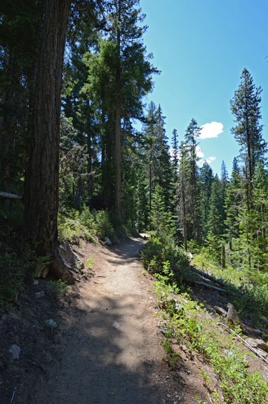
The Photo Stops

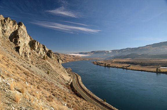
The weather in Wenatchee had been clear with temperatures in the high 20s or possibly low 30s. But as I drove up the west side of the river, I saw low clouds up ahead. That’s a weather phenomena that’s pretty common here in the winter: fog. As the road climbed up toward the tunnel that would lead away from the river and toward Chelan, I stopped for a photo.

Up River Fog
As I climbed away from the river, I could see a fog bank off in the distance.

Tunnel to Chelan
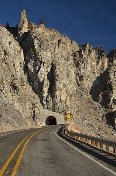
Route 97A passes through this tunnel on the way to Lake Chelan.

I passed through the tunnel and into the hanging valley beyond. The area was familiar to me, yet strange. I’ve flown that way dozens of times in my helicopter, taking people to Tsillan Cellars Winery on the lake. But I very seldom drive that way. I kept expecting to see the lake revealed before me. It wasn’t until I began descending down toward the lake that I finally caught a few glimpses of it. The helicopter ride offers much more dramatic scenery.

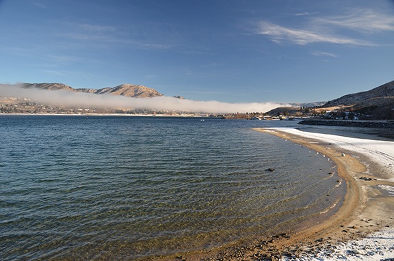
There was a thin fog layer right over the water. It was probably about 10-20 feet thick and started at maybe 5 feet off the lake’s surface. To the east a thicker bank of fog hung over the town of Chelan. The sky and water were blue; the snow and ice and clouds were bright white. I could see for miles and miles, all the way uplake to the snow-covered mountains off in the distance.

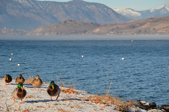
I stopped for a few more photos, pulling down a street that hadn’t been plowed. My Jeep’s fat tires crunched in the icy snow.

Ducks on a Mission
These ducks were snoozing until I knelt down on the ground to put them in the foreground and the snow-covered mountains in the background. Then they marched toward me; I suspect they thought I was there to feed them.

Fog over Chelan
A layer of fog hung over the town of Chelan.

I drove into town. There were few cars on the road, few people around. Winter in a summer resort area. The road had patches of ice and, more than once, my rear tires spun as I moved away from a stop. Slow and easy; I was re-learning my winter driving skills as I went along.

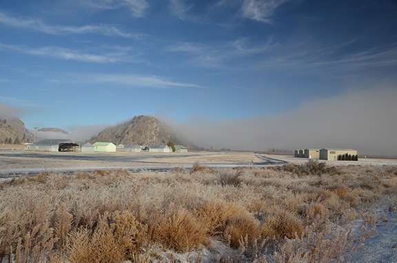
The fog thickened as I followed the road through town and up toward the airport. At one post, visibility was down to less than 300 feet. Along the road I caught glimpses of the Columbia River far below me. Downriver, the sun was shining through the clouds. Up ahead it was cloudy and gray.

Marginal VFR
It was marginal VFR at the airport but no one was flying. The thick frost you see on the weeds is from freezing fog, another common weather phenomena here in Central Washington State.

Route 97A descended from the airport and joined up with Route 97 to continue up the Columbia River. It was a completely different day, with low clouds and a dismal winter feeling.

Refueling at Pateros

I didn’t stop until I got to Pateros, where I pulled over to top off the Jeep’s fuel tank. I took a short drive through town, getting as far as the Lake Pateros Motor Inn, where we’d stayed in back in 2008. I’d parked my helicopter on the lawn alongside the hotel in a spot that made it very convenient for the few cherry drying flights I did.

I stopped at the Sweet River Bakery, where my wasband and I had come for breakfast each morning during our 10-day stay. Back then, they made the best apple fritters. I ordered an eggnog latte and got an apple-cranberry fritter to go. I’d have it for breakfast in the morning.

We got back on the road, backtracking down to where route 153 turned west along the Methow River. I passed the farm stand with a cherry orchard I’d dried. It was closed.

A Drive Up the Methow

Along the Methow River
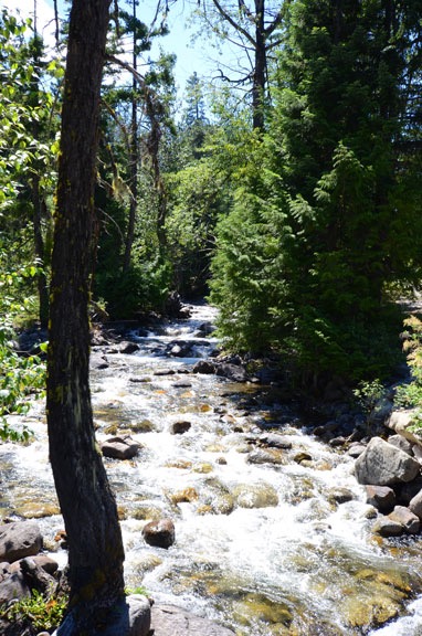
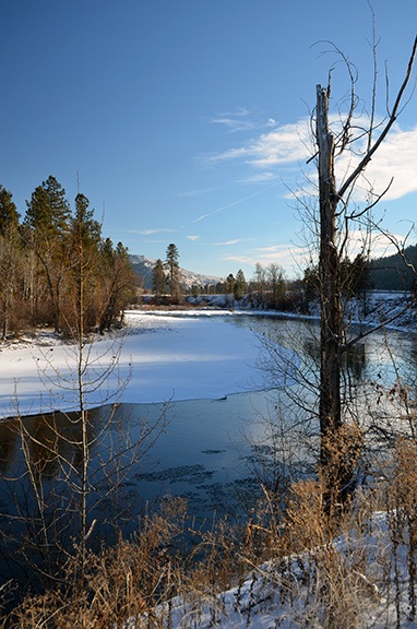
Snow, ice, river, sky, trees dormant for winter. I didn’t realize how much I missed winter scenery until I took this trip.

There was ice on the river — so much ice, in fact, that it looked as if I could walk across it. But as I drove upriver, the ice cleared out at the rapids.

The road climbed gently but persistently along the river. The amount of snow along the way increased as we climbed. Soon, we’d climbed away from the fog bank and the sun began to shine again.

It was a really amazingly beautiful day. I stopped for a few more photos. I wanted to remember this trip and the best way to do that would be to document it with photos to act as visual clues. Besides, it was just too darn pretty to pass up.

That’s another benefit of traveling alone; I don’t have to ask permission to stop so I can get out with my camera.

Red House on the Methow
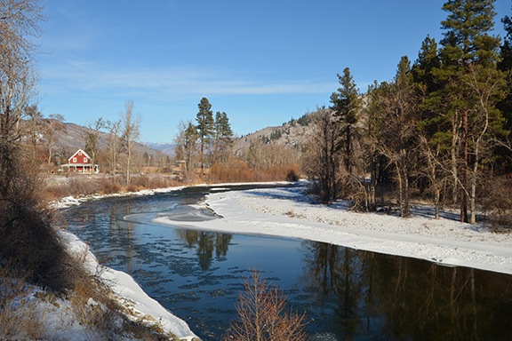
At first glance, the reflection of the red house on the river was much more obvious than I was able to capture with my camera.

I passed through Methow and noticed a restaurant on the side of the road. I have vague memories of having dinner there and there being live music. But it was closed and quiet that Christmas Eve day.

Everything was quiet. I was just about the only car on the road. No traffic! How many other Christmas travelers could say that?

Carlton was a sign and nothing more.

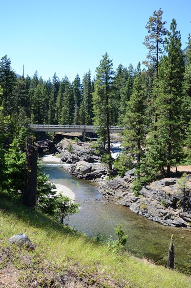
The road twisted and turned along the river, crossing one bridge after another. I reached the junction of Route 20, where route 153 ended. A right turn would eventually take me to Okanogan — which I’d only been to by helicopter in a fly-by years ago. I continued on to Twisp.

The friend I’d visited at work earlier in the day had told me to stop at Twisp’s bakery and the health food store next door. I was hungry for lunch — it was nearly noon — but I didn’t feel like bakery food. The Grover Street Market had a lunch counter, so I went inside to see what healthy choices they offered. I wound up with a bowl of their Curry Stew, which was more like a soup and served so piping hot that I couldn’t eat it at first. It was tasty, with just enough spice to make it interesting. There was enough for two meals so I took half of it to go.

I didn’t visit the Cinnamon Twisp Bakery. I figured I’d visit it on my way back. (That turned out to be a mistake; it was closed on Thursday.)

I took Penny for a short walk through town. Not much was going on, although there were plenty of parked cars. It was sometime around then that I realized that plowing the roads in Washington was optional. All the side streets in town had a reasonably thick layer of icy snow on them. Not really slick — I think they spread gravel or something on them — but certainly not plowed to pavement. They apparently expect people to know how to drive in this kind of snow cover. And people do.

Of course, there were an awful lot of four wheel drive vehicles around.

Winthrop and Beyond

For some reason, I thought I had 20 or more miles to go before I reached Winthrop. I didn’t. It was just about 10 miles down the road.

I pulled out my driving instructions and followed them to Wolf Creek Road and, eventually, to the Chickadee Cabin Loft where Penny and I were staying. It was an upstairs studio apartment in a four-unit building. Next door was vacant but the two downstairs units, which were much bigger, were occupied. The place was at the end of a road in the woods but on the edge of a clearing. The roads weren’t plowed but the Jeep had no trouble getting us where we needed to go.

The “loft cabin” was nice, with a queen-sized bed, futon, TV with VCR and DVD player (and satellite TV), Internet access, kitchenette, and bathroom. There was even a sliding glass door leading out to a small balcony that overlooked a snow-covered meadow. All this was about 6 miles from town.

I unpacked the food and checked the cabinets. There was coffee and coffee filters and even sugar. All I needed was some milk and maybe some yogurt for breakfast. I’d get that in town.

We climbed back into the Jeep and headed into Winthrop. I wanted to find out what trails, if any, were open to cross-country skiing. I figured there would be some kind of ranger station with information in town.

What I found was the local office of the MVSTA. I parked out front and went inside, leaving Penny behind in the Jeep. I spent the next 20 minutes chatting with the two folks inside about which skiing trails were open and where I could get a lesson. It looked like Mazama was the place to be — 15 miles farther up route 20 was where there was more snow and most of the groomed trails. I bought a 3-day pass — in hindsight, two 1-day passes would have saved me a bit of money — and the woman behind the counter called the Methow Valley Ski School up in Mazama to see if they were still open. It was nearly 3:30 PM on Christmas Eve.

A while later, we were in Mazama and I was arranging for a cross-country ski lesson the following day. I brought in my skis and was told that waxless skis need to be waxed — something honestly I didn’t know. I paid for my lesson and a tube of ski wax.

I stopped in next door at the Mazama Store, a new agey market with lots of organic and overpriced food and other merchandise. (I do tend to tell it like it is.) I paid $7 for a quart of organic yogurt and $3 for a quart of organic milk. I also bought a fleece sweater that I wound up returning two days later. I do have to say one thing about the store, though: It has the largest selection of Lodge cast iron cookware I’ve ever seen under one roof. If Lodge makes it, the Mazama Store sells it.

By that time, it was after 4 PM and the sun was setting somewhere behind the mountains all around me. It would be getting dark soon. I loathe driving in the dark these days and had no reason to stick around Mazama so we headed back.

Along the way, I saw plenty of snow-covered fields with a thin layer of fog drifting over them. Advection fog? Radiation fog? I tried to remember what I’d learned in ground school about fog and came up empty. Fog was rarely an issue where I flew in Arizona; it was certainly an issue here in the winter time.

I stopped briefly in Winthrop to take Penny on a quick walk around town. I was curious to see what was open. There was a hotel with a restaurant in town and I walked up the steps to see if it would be open the next day for Christmas dinner. Closed. No big deal. I knew I’d be able to get Christmas dinner at the nearby Sun Mountain Lodge resort if I wanted to.

It was almost dark when Penny and I returned to our loft cabin. I put away the groceries and heated up some leftover smoked ribs for dinner. (I’d made them the day before on my Traeger just so I’d have something to munch while I was away.) We spent the evening relaxing, reading, watching TV.

A nice rest at the end of a long day.

(continued)