The challenging part of this photo flight wasn’t the photo flight.
It had been on my calendar for months: take a photographer to fly with a rebuilt 1914 Curtiss F Model Flying Boat, supposedly the only one in existence from the 300 originally built.
My friends Mark and Karen at Century Aviation had been working on it for over a year, restoring it for businessman and aviation enthusiast Bill Nutt from the few parts they had managed to acquire. I saw the start of their work at their annual hangar party in the summer of 2017. By June’s Aviation Day event at the airport, it was pretty much done and on display in one of the FedEx hangars.
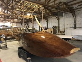
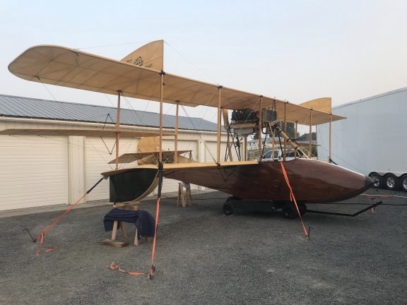
The Flying Boat project in August 2017 (left) and in June 2018 (right) when it was pretty much finished. Fun fact: There are more than 8,000 tiny screws holding the wood planks in place on the plane’s hull.
The great thing about this restoration is that the owner wanted a fully functional plane. That meant it had to fly. So they scheduled a test flight for July and contacted me about taking along a photographer to document the flight. Unfortunately, some engine issues caused a postponement and they had to work around the pilot’s schedule. He was next available in mid August so that’s when we rescheduled the flight.
The folks at Century had to disassemble the plane, stow it in a custom trailer built just to transport it, and tow it down to Moses Lake, which was where they planned to fly it. The plane does not have wheels or any landing gear at all; it’s a boat and can only take off and land in water. Although the Columbia River is right here, they felt that Moses Lake, about an hour away by car, would be better. Less possibility of crowds and boat traffic and no obstructions like overhead wires, bridges, or dams. They also needed a place to reassemble and launch the plane; they arranged with some folks who lived on the north end of the lake to use their property.
They drove down on Monday morning and spent the day working on the plane. The test flight was scheduled for Tuesday with the possibility of trying again on Wednesday if necessary.
Getting There
Spoiler alert: the most challenging part of the mission for me was just getting my helicopter to Moses Lake.
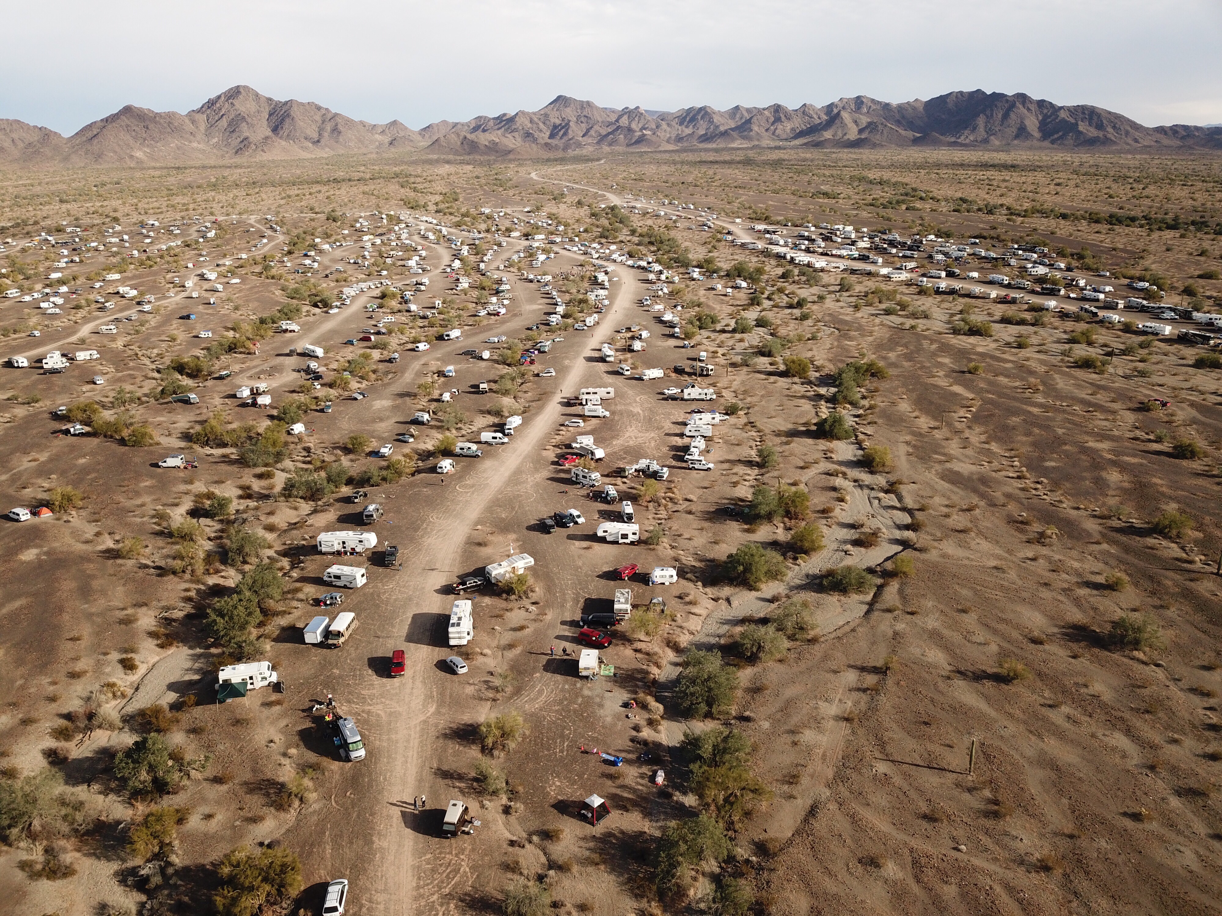
We’d decided that I’d go down on Monday so I was ready first thing in the morning to fly. I packed a tent and sleeping bag, all prepared to camp out in the yard. I also brought a cooler with ice and water and a bed for Penny.
I watched the weather all day. I wasn’t worried about storms — it was visibility that was an issue. For three weeks, we’d been dealing with smoke from various fires north of here. The smoke drifted into the Wenatchee Valley and settled in, thick enough to smell. I monitor air quality via an app and website and smoke was giving us “Unhealthy” and even “Hazardous” air. Visibility at the airport just four miles away had gotten as low as 3/4 of a mile. That day, it was hovering around two miles.
Wenatchee Pangborn Memorial Airport has class E airspace. That means that when visibility drops below 3 miles, I can’t fly there without a special VFR clearance. Trouble is, there is no tower at Wenatchee so to request my clearance I need to contact Seattle Center. And the problem I encountered that afternoon, as I idled at my landing zone in a deep valley, was that I simply couldn’t reach Seattle Center on the radio.
I could reach the local Flight Service Station, however, so that’s who I called. They relayed my request to Seattle and relayed the response back to me. There was a plane on approach and I couldn’t get my clearance until he was on the ground.
So I sat there, spinning, burning fuel, grateful that the helicopter has air conditioning. I listened in on Wenatchee’s radio frequency and heard the plane call 10 miles out. That kind of pissed me off because I had a 3-minute flight ahead of me and could have done it at least twice before he even entered the airspace. But okay. Whatever. I waited.
Then he was on the ground and a helicopter made a call. Shit. How did he get clearance before me?
I called Flight Service again to remind him that I was still waiting. He mentioned the helicopter and then told me to hold. I held. Eventually, he came back and gave me my Special VFR clearance to reposition to the airport. I wasted no time climbing out and heading across the river.
It had taken me about 20 minutes from startup to landing less than four miles away.
I ordered fuel, wondering how long it would take for me to get out and on my way to Moses Lake.
Fortunately, the wait to depart was much shorter. After topping off both tanks and checking the oil — hot dip stick! — on level ground, I started back up. This time, I called Seattle Center directly. They had me hold until a cargo plane that had just departed cleared the airspace to the west and then cleared me to depart Special VFR at or below 10,000 feet. Easy enough; I had no intention of losing sight of the ground.
Instead of flying direct, I departed the airport and descended down until I was about 400 feet over the river. The problem with the direct route is that it would take me right over the top of Lower Moses Coulee, which is a relatively wide canyon east of the airport. I worried that once I left the canyon’s west rim I might lose sight of the ground below me and the opposite rim. I don’t like to lose sight of anything when I fly and I wasn’t taking any chances.
I watched my position on Foreflight’s moving map and called Seattle Center to report clear of Class Echo when I was abeam the mouth of Lower Moses Coulee. By that time, I was low enough between the cliffs on either side of the river to have garbled communications with them. I thought I heard them ask for my altitude and heading so I reported both. Then I changed frequencies, eager to silence their nearly constant communications with airliners coming and going around Seattle.
I followed the river down to Crescent Bar and then climbed up over Babcock Bench before setting course for Moses Lake. The farms and orchards of Quincy emerged below me out of what looked like a fog. Visibility was slightly better than it had been in Wenatchee. The air was smooth and I was very surprised to discover, when comparing airspeed to groundspeed, that I I had about a 15 knot headwind. No turbulence at all. I turned on my radar altimeter — the $10K piece of equipment the FAA made me buy — because I was curious about how high up I was comfortable flying in the muck. 350 to 450 feet. I soon lost sight of the hills north of Quincy and had some trouble staying on course with nothing on the horizon to aim for. The radio, tuned into Quincy’s frequency and then Moses Lake’s, was eerily quiet.
My landing zone was on a piece of land three miles west southwest of the airport, within the Class Delta airspace. That meant talking to the tower. Fortunately, visibility there was four miles so a Special VFR clearance was not necessary. I told the controller where I planned to land and he cleared me for transition. I was just setting down when I reported landing assured.
On the Ground in Moses Lake
They had a sprinkler going in an area that would have been a good landing zone, but I didn’t know if they expected me to land there so I didn’t. Instead, I landed in a spot between a small orchard and some overhead wires. There was a burn pile nearby and I was so focused on that, wondering if I’d blow it away, that I was a bit surprised when my left skid touched down before my right one. There was a little slope to my landing zone, but not enough to be an issue. I set down, reduced the throttle to cool down RPM, and opened the door. I dropped Penny out to investigate while I finished shutting down.
One of my hosts, Lois, appeared moments later. When I shut down and got out, she greeted me. She immediately offered up a bed in the house. Faced with the choice of a bedroom near a bathroom or a tent in a smoky yard, I agreed to take the bed.
The plane was parked in front of Lois and Virgil’s garage, sheltered on one side by its big transport trailer and on the upwind side by a motorhome. It was tied down firmly at four points; it would be tragic indeed if the strong wind coming out of the east blew it over.
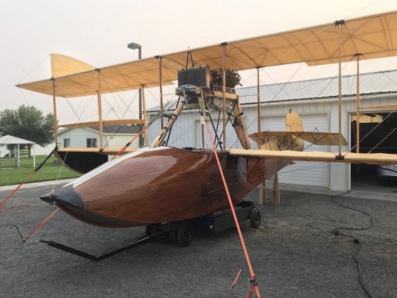
The plane was securely tied down in the driveway, sheltered from the wind on three sides.
Then Karen, Century’s co-owner, pulled up in her car and whisked Penny and me away to a Mexican restaurant in downtown Moses Lake. The Century crew, the plane’s owner (Bill), and a bunch of friends — I think there may have been 20 of us — sat a long table. We enjoyed drinks and huge portions of Mexican food, treated by Bill.
Afterwards, Penny and I hitched a ride back to the landing zone with Bruce, who was staying in the motorhome. (The others were staying in two rented houses in town.) That’s when he told me about flying helicopters in Vietnam and gave me a firsthand account of his participation ferrying people out during the fall of Saigon. He said that they had to toss the helicopters into the water because the helicopters waiting to land were running out of fuel and ditching and the rescue crews were working nonstop to pull people out of the water. (Seriously, kids: never pass up an opportunity to talk to an older person about the amazing things they were part of in their lives.) Now he flies freight in airplanes for a living, but he wished he’d gotten his civilian helicopter rating.
Back at the landing zone, a young guy in a uniform was hanging around by a pickup truck parked near the plane. Hired security. He’d be spending the night. I thought it was completely unnecessary — heck, you couldn’t see the plane from any road or the lake — but better safe than sorry, I guess.
I chatted with my hosts for a while before turning in. I’d been up since 4 AM, which is relatively common for me, and was tired. My bedroom was small — barely big enough for the queen sized bed! — but the bed was comfortable and the place was quiet. After feeding Penny some chicken and rice from my dinner — I’d forgotten to bring dog food which she probably wouldn’t have eaten anyway — I set up her bed on the corner of mine and turned in. I slept relatively well.
Fly Day
I woke around 4:30. This is one of the reasons I hate being a houseguest. I wake up very early and then I have to stay very quiet until other people wake up. So I did what I often do: read articles on the Web, visit Twitter, complete crossword puzzles. That took me to nearly 6 AM. By that time, it was daylight and I was ready to go outside. So I dressed, washed up quietly ,cleaned up the room, gathered my belongings, and slipped outside with Penny in tow.
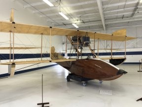
The plane was safe and sound in the morning. On the right side of this shot, you can see part of the trailer it travels in.
The security guy was gone. Virgil was awake, doing stuff outside. I helped him pick raspberries from his garden for breakfast. We chatted, skirting around the issue of politics. He started to say something about liberals, thought better of it, and was likely relieved that he had stopped talking when I admitted that I leaned left. I said that I wished people would gather information from reliable sources and form their own educated opinions rather than latching on to the opinions of others. And we left it there.
Back in the house, Lois was making breakfast, which consisted of a lot of fresh fruit, oatmeal (the kind you cook, which is honestly the only kind worth eating), and meatless sausage and potato patties. There was no coffee, which I (mistakenly) thought wouldn’t be a problem. Virgil said grace before we put food on our plates. He had a lot to say to the Lord that morning, from thanks for the food to requests for good weather and a successful flight.
Other people started arriving after 7 AM. Bruce came in and joined us. Then some other folks. Soon we had a bunch of cars parked haphazardly around the place and people going in and out to use the bathroom. I thanked my hosts for breakfast and went back outside, where Penny was already giving hell to the three-legged dog from next door.
The crew got right to work on the plane. They had to check all the wire fasteners for tightness, add oil and fuel, and do countless other things I have no clue about. There were ladders all over the place. I managed to get a few interesting shots of the plane and its controls while they worked.
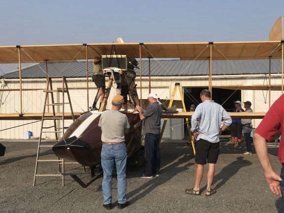
The crew works to prepare the plane for flight while others look on. That’s the pilot, Rob, in the black shorts.
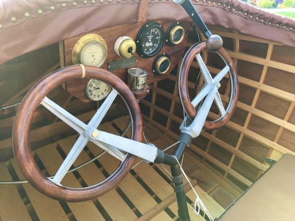
The cockpit is pretty simple. For this flight, they had the “everyday” fabric seat cushions in. The leather cushions they made will likely be installed when its on display.
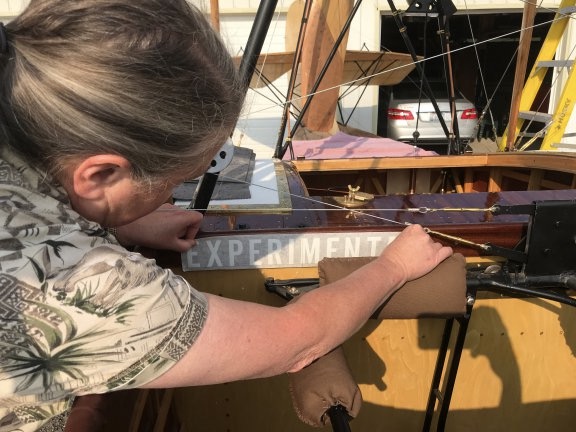
Karen affixes the Experimental placard to the inside of the cockpit as required by the FAA.
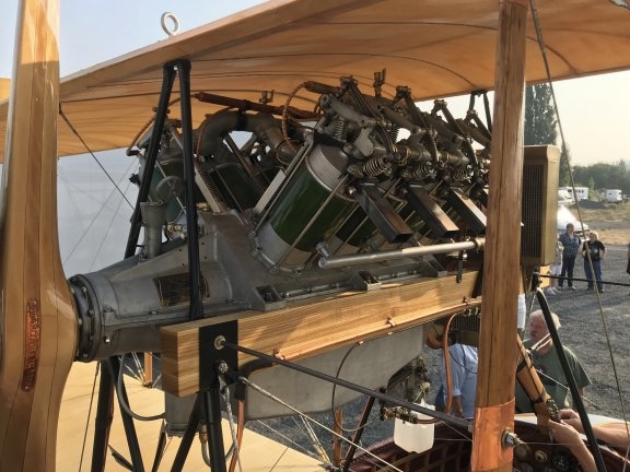
A closeup of the Flying Boat’s engine with pusher prop. This is (obviously) not the original engine, but it was built specifically for this plane based on period designs. You can see Mark’s face framed by the engine supports just below the radiator.
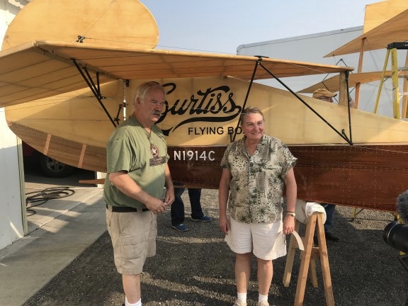
Mark and Karen pose by the plane’s tail for an interview by NCWLife, a local television channel.
First Try
We got all the cars moved out of the way and Virgil moved the motorhome. Mark did a briefing on what would happen next and they started moving the plane, on its cart, down to the water. I had my phone out with a battery pack on it and Periscoped the whole thing. It was long and, in more than a few parts, boring. That’s because it happened at the speed of real life, which tends to be slow. Mark and Karen weren’t taking any chances rushing through things.
Of course, I wasn’t there to put the event on social media. I was there to fly a photographer in my helicopter. That means I needed to be ready to fly when they were. At first, Mark asked me to get the helicopter going just before they started the engine, but when he realized how much I wanted to hear the engine, he said to do it right after they started. So I stuck with it, narrating and answering questions along the way. There weren’t many viewers until right around the time they started the engine. So instead of shutting it down, I handed it off to one of the other bystanders. Apparently, she wasn’t as dedicated as I was and eventually put the phone down without turning off the video. If you do watch it, have patience.
I’d already briefed the photographer, Steve, and told him he could keep shooting until after I got the helicopter started. So it was running when he joined me. I helped him with his life vest — I always supply flotation devices when doing photo flights over water — and made sure he was strapped in. Then I made a radio call to Moses Lake tower, telling the controller we’d be operating over the lake. They were already briefed about what we’d be doing and I’d likely be operating below the airport field elevation anyway. For the rest of the day, all I had to do was call when I took off and call again when I landed. It was automatically assumed that the Flying Boat would be operating at the same time.
When we took off, the plane was just taxiing into the lake. I formed up immediately with it, flying on its left (port) side. Steve is a smart guy who had no problem with my request to sit behind me for the flight. Doing so made it possible for me to see exactly what he saw and put him in position to get the best shots. I’ve dealt with too many stubborn photographers who expect me to get them into position when I can’t see what they’re looking at. I now require all photographers to sit behind me for air-to-air flights.
Rob took the plane down the lake, slowly building speed. We followed off his left shoulder. At first, I was kind of high — the water was glassy smooth and I really don’t like flying low over featureless surfaces. But I worked my way down, matching the speed of the plane below me at or below 100 feet over the water.
It wasn’t very eventful. He didn’t get very far. After a while, he killed the engine and the boat drifted to a stop.
I circled a few times as a boat with some of the crew on board motored over. Of course, I didn’t know what was going on. The Flying Boat didn’t have a radio and my cell phone was with Rita. When they came out with a jet ski and started towing it back to base, I headed back in and landed.
By the time I’d shut down and returned to lakeside, the plane was back. It turned out that there were multiple problems:
- Water was getting into the boat’s hull. This was probably a combination of seepage and possibly a leak or two.
- The engine wasn’t getting enough power to get the plane up to speed.
- There wasn’t enough rudder to steer the plane properly.
Needless to say, we were all very disappointed. As I watched them bail out the plane with a small bucket, I started wondering if the whole thing was a failure.
Second Try
It was still early in the day and the place was crawling with mechanics and engineers so there really wasn’t any reason to give up. I went with one of the guests to a sporting goods store to buy a handheld pump to make it easier to get water out of the boat. Because I had a splitting headache likely caused by caffeine withdrawal, we stopped at an espresso stand for an iced latte. (It worked! Headache was gone before we got back!) Then Home Depot to get some hose.
While we were gone, they did something with the rudder cables to improve steering. Oddly, the design they’d worked with had a wooden block back in the tail; they had no idea what it was for but included it anyway. Apparently, it was to tie the cables in such a way that they wouldn’t rub against another part when the rudder was full left or right. So they were prepared for the fix. I imagined a mechanic back in 1912 having the same problem and solving it with that little wooden block.
Meanwhile, we had lunch — sandwiches with fresh tomatoes from the garden. Penny shared some of my turkey.
Then they were ready to try again. Steve and I headed out to the helicopter. This time we were airborne before they started the engine. We got to see Mark crank it — there was no electric start — and the prop start spinning. Then Mark climbed out of the way and Rob took his seat. As we circled about 200 feet up, he headed off into the lake.
This time, Steve and I paid closer attention to the way the plane moved in the water. We realized that spray from its movement was coming up under the rear horizontal do-dad — heck, sometimes I really wish I knew airplane parts! — and spraying up against the rudder. The hull seemed to ride low in the water. Although Rob seemed to have better steering control, he still didn’t get enough speed to take off. So he killed the engine again. The boat and jet ski moved in and I went in to land.
Third Try
One of the crew bailed out the boat with the hand pump while the others talked to Rob. It seemed that the steering problem. But the water getting in the boat was weighing it down and it seemed to be too low in the back. They decided to try ballast.
They filled two big black garbage bags with gravel and weighed them. I didn’t get the weights. They took one of the bags and secured it at the very front inside the plane’s hull. They were turning the plane around to face the lake when Steve and I headed back to the helicopter.
We launched and circled as they started it back up. It headed out to the lake. The tail was definitely riding higher in the water. Rob seemed determined to get it up to speed as quickly as possible — possibly to minimize water in the hull. He took it pretty far down the lake and I really thought he might take off. But then, suddenly, he killed the engine and let it drift.
It looked for a moment as if the wind might blow it to the opposite shore of the lake, but then the jet ski came out and attached the tow rope and they were headed back. I was back on the ground looking for chocolate chip cookies before they got back.
Fourth Time is the Charm
The verdict was that the weight in the front definitely helped but they needed more. So they secured the other bag of gravel. As they turned around the plane, Steve and I headed back to the helicopter. As I lifted off and called the tower, I said “Let’s hope fourth time is the charm.”
“Good luck,” he replied.
Again, we circled the plane as they started it up and Rob taxied it out. He headed down the lake, right into the wind, picking up speed quickly. He wasn’t messing around — he clearly planned to get it off the water if possible. I had a feeling that they’d all agreed that this would be the last try.
I dropped down as low as I dared, watching the plane the whole time. It looked light on the water.
“I see light under the tail,” Steve called out.
And then it lifted off the water and into the air. It was flying.

An aerial view of the Flying Boat flying over Moses Lake for the first time on August 21, 2018.
I keyed the mic; the radio was still tuned into Moses Lake tower. “The flying boat is flying,” I told them.
“Fourth try was the charm,” the controller replied. “Congratulations.”
Meanwhile, Steve was snapping photos like crazy. The plane kept moving and I kept moving along with it. It got about 50 feet off the water. It came down for a landing, skirted along the top of the water briefly, and came back up into the air. It flew for a while longer.
We’d gone well over a mile from base and were coming up on a bend in the river with a bluff ahead of us. Our FAA authorization limited the plane to straight and level flight, so it was time to come back down. Rob landed, turned around, and started motoring back on the water, moving fast. For a moment, I thought he might try a tailwind takeoff — the wind wasn’t blowing more than 10 miles an hour — but no, he was just in a hurry. He came all the way back, past base, and turned around. I got the feeling he was going to try another takeoff where onlookers could actually see him. He sped up a bit, crossed the lake, and pointed into the wind. He started moving quickly, but then shut down. I suspect that water in the hull was weighing him down again.
And that was it. We circled around a bit while the boat and jet ski moved back into position to bring him back. I landed and Steve got out while I cooled down the engine and shut down.
Winding Down
Needless to say the entire crew — and the onlookers — were euphoric. The day had started bad but ended great. The only thing that really disappointed the onlookers is that they hadn’t been able to see the plane actually fly; it was too far down the lake for them to see.
I gave helicopter rides to my host and his grandkids. Then I watched them pull the plane out of the water and tow it back up the driveway. I said goodbye to everyone, adding congratulations to Mark, Karen, Bill, and Rob. Then I loaded the helicopter back up, gave one last helicopter ride to the folks who had let us use their boat ramp, and headed home.
Visibility was much better; I didn’t need a clearance to get back into Wenatchee airspace. Still, I followed the river from Crescent Bar. The water was smooth as ice. I was almost disappointed to set it down at the end of the flight, but I had places to go and things to do and I was already late.
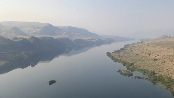
Just downriver from the mouth of Lower Moses Coulee, the water was glassy smooth.
I Live for This
I realized several times during the 24 hours I was part of the Curtiss Flying Boat crew in Moses Lake just how much I enjoy things like this. I live for opportunities to be part of something amazing and this restored plane was definitely that.
It reminded me a lot of another classic airplane project I’d been involved with back in the early 2000s, when I was still flying my first helicopter, an R22. Back then, it had been a replica 1919 Vickers Vimy, the world’s largest flying biplane at the time. That project predates my blog so I don’t have any posts about it. I can’t even find any photos of it, although I’m sure I have some somewhere. My involvement was several months long but ill-fated; I have a very low tolerance for incompetence and the project was very poorly managed when I was part of it. Still, it was fun flying in formation with a giant four-engine biplane and I did very much enjoy my one and only ride.
Life is short; we need to make the most of the time we have. For eight years out of college, I worked the nine-to-five grind and I pretty much hated it. I was living inside the box that society builds for most of us, the box my family clearly expected me to stay inside as I worked my way up a corporate ladder I had no real desire to be on. Surely there was more to life than an hour-long commute to sit in a cubicle before another commute to get home, repeated daily five times a week, 50 weeks a year.
I got a glimpse of just how much more was out there when I started my second career, as a freelance writer, and got to travel, see more of the country, and speak at computer conferences in San Francisco, Boston, New York, and Toronto. Traveling from hotel to hotel, setting up classrooms for training, teaching people what I knew, getting tastes of the cities I visited. Meeting with publishers and software developers. I enjoyed my behind-the-scenes participation as a computer trainer, speaker, and author.
Later, as my helicopter career began to grow, I got a chance to be involved with the kind of flying missions that most people never even imagine: multi-day helicopter excursions, raptor surveys, pipeline patrols, Grand Canyon tours, desert racing photo flights, cherry drying, frost control, air-to-air photo flights, cattle spotting, horse herding.
I cannot imagine a life without these fascinating kinds of work. A life where every day is the same as the day before it — and the day after it. How do people do it?
And it’s not just the work — it’s the people I meet along the way. People like a businessman who pays to restore classic aircraft to share them with the world. People like the aircraft restorers who can take a pile of scrap wood and fabric and turn it into a beautiful working airplane. People like a helicopter pilot who made 15 flights to help evacuate Saigon before he helped them push his helicopter off the ship. People like an airplane pilot who has flown several airplanes dating back to the early 20th century, when aviation was in its infancy.
Time for a shameless plug…
If you like helicopters, you’ll love the FlyingMAir YouTube Channel. Check it out for everything from time-lapse annual inspections to cockpit POV autorotation practice to a flight home from a taco dinner at a friend’s house — and more.
I have to add — because it was on my mind so many times on Tuesday — how sad I feel for my wasband, who could have been part of all of this if he hadn’t been so fearful of joining me in my life outside the box. The man I knew well — before he apparently lost his mind — would have really enjoyed the experience, even if he had been stuck on the ground for the flight attempts. He was an engineer, after all, and the plane is fascinating. I could almost imagine him talking to the mechanics, asking questions and learning about the plane’s idiosyncrasies. But I also know that if we’d stayed together, I’d likely miss out on so many of the opportunities I’ve had since our split. What’s sad for him is good for me. I’m sure he’s perfectly happy with his life inside his box. He’ll never know what he’s missing. Most people don’t.
But this is what I live for — experiences that make my life fuller and more interesting. And I’m always looking for the next opportunity.
Want More?
Watch this video produced by NCWLife: