I Am a View Person

It’s not about how big or fancy or well-furnished my home is — it’s about what’s out the windows.

I’ll admit it: I’m selfish. I’m not interested in living in a showplace bought and decorated to impress my family and friends. I don’t care about how big my home is, how many rooms it has, or what designer furniture and fixtures it contains. I don’t care about Pier 1 nicknacks obtained only to fill empty spaces on tables and walls. I don’t care about aromatherapy candles to make my home smell like cinnamon and spice or vanilla or whatever the current season is.

What I care about is what’s outside the windows. I want a view.

And the better the view, the more windows I want to enjoy it, day or night, from the comfort of my home.

It all started back in my college days with my dorm room on the 14th (top) floor of one of Hofstra’s six “towers.” It faced east, with windows that covered one wall. It was only 8 x 12 in size but with a high ceiling that allowed a friend to build me a loft for sleeping. I spent a lot of time looking out those windows, at the other towers nearby and the flat expanse of Nassau County in Long Island. If I’d been on the opposite side of the building, I would have had an unobstructed view of the Manhattan skyline less than 30 miles away.

Later, I lived on the third floor of a row house in Bayside, NY. The big windows and patio overlooked that overlooked Littleneck Bay. It wasn’t the best view, but it was something. Even the constant swoosh swoosh swoosh of cars on the Cross Island Parkway 100 feet below couldn’t detract from it.

Still later, when I moved from the east coast to Wickenburg, Arizona, I was sold on my home primarily because of the view. It looked out to the northeast where I could see the Weaver Mountains beyond a nearby ridge. It also looked out to the southwest, where I could see the top of Vulture Peak. The views were not perfect but they were nice. I especially liked to watch the Weaver Mountains turn almost copper-colored as the sun set.

Looking for an escape from Wickenburg’s oppressive summer heat, I looked at land at Howard Mesa Ranch, a development of 10- and 40-acre lots between Williams and the Grand Canyon. The lot that hooked me was on the very top of the mesa, with amazing 360° views. Although I could see the snow-capped San Francisco Peaks to the east, it was the expansive view to the west that captured my heart. I wanted so badly to build a small home up there with big windows to take in those views, but it was not to be.

Jack the Dog at Howard Mesa
My dog, Jack, looking out over my favorite view at Howard Mesa. The view to the west was expansive — I could often see mountains on the Arizona Strip more than 80 miles away.

In 2012, at the start of my fifth consecutive summer in the Wenatchee area of Washington, I started thinking of a summer homesite in the area. I often visited Malaga Springs Winery on Cathedral Rock Road; it had excellent views out toward the Columbia River. A friend owned land out there and, on a whim, I called to ask who his Realtor was and whether he knew of any lots that were available nearby. Coincidentally, he and his wife had just decided to sell their lot. They’d decided that they were a bit too old to start building their dream home.

Of course, I was immediately sold on the lot. The views were amazing — far better than Wickenburg or even Howard Mesa. Spread out before me were orchards and sagebrush-covered hills, basalt cliffs, and the Columbia River snaking through the broad Wenatchee Valley. I blogged about buying it here.

My New Home
Here’s a shot of the west end of my 10-acre lot, taken from the hillside on the south border of my land. My mobile mansion looks tiny here, no?

But it wasn’t until I moved here — in my RV until my home can be built in the spring — that I realized just how amazing the views were. Every moment of the day, every change of the light or clouds, every day of the year — the view changes. Don’t believe me? Here are three shots from this week, all shot from the front door of my RV.

Cloud View
The sky isn’t always this dramatic, but it was yesterday afternoon. One of my Facebook friends said it looked like the mothership was about to descend.

View at Night
Believe it or not, it wasn’t until I moved here that I was here at night. The nighttime view absolutely floored me. Best of all, I’m still far enough from Wenatchee to have dark skies overhead.

First Light
I shot this photo this morning, not long after sunrise. Yes, that’s snow on the mountains in the distance. Although some of that snow is relatively fresh, there’s snow up there year-round.

My Bad View
My “bad” view isn’t too shabby, either.

Wondering what the view looks like in other directions? Well, the photo here shows my “bad” view — the basalt cliffs on the south side of my property. My first home will be built on this patch of land, leaving the area where my RV is currently parked available for a larger home if I need (or want) one. (Local zoning allows two residences on lots of this size, as long as one of them is 1200 square feet or smaller.)

And you can bet my home will have lots of big windows looking out over the big views I’m showing off here.

In any case, I love the views and I love to share them with my friends and family. So don’t think I’m bragging when I keep posting photos on Facebook and Twitter and this blog. I’m constantly amazed by what I’m seeing and I want you to be amazed, too.

I’m a view person. Are you?

The Joy of Flying with an Experienced Professional Videographer

Makes me wonder why I bother with the amateurs.

I had a great flight yesterday. A flight that should stand as a shining example of the kind of flying I love to do with the kind of professionals I like to work with. Let me tell you about it.

But first — because I can’t keep a short story short — some background.

Dealing with Amateurs

I feel the pain of professional photographers — folks who have invested thousands of dollars and years of their lives accumulating quality photography equipment, learning their craft, and practicing until they know how to make every shot count. These people are now competing with amateurs who buy DSLR cameras and call themselves “photographers.” These people use the “shotgun approach” to photography — they shoot dozens of images with the hopes that one or two of them will satisfy their client. They undercut the professionals in pricing because they simply don’t have as much invested in the business and, indeed, some might even have other jobs to support them. The professionals are losing jobs — and their livelihoods — because the amateurs are taking away their clients.

As a pilot providing aerial photography flights, I see this a lot. I get calls from photographers and videographers looking for a platform to get their aerial shots. If they don’t balk at my prices, they usually come in with a set time limit to minimize their flying costs. I can understand this — to a certain extent, anyway. Then they arrive for the shoot and immediately begin to show just how amateurish and unprofessional they are by:

  • Bringing the wrong equipment. I’m talking about consumer quality cameras and lenses, telephoto and long zoom lenses, DSLRs for video, and bulky camera bags full of equipment they will not need and likely cannot access anyway during the flight.
  • Ignoring my advice for seating. If they’re serious about getting good shots of a specific target, they should sit behind the pilot. That’s the only way the pilot can see what they see.
  • Bringing two photographers with two different missions. Usually it’s a still photographer brought along on a video flight. That simply isn’t going to be as cost effective as they think if they take my advice and put the primary photographer behind me.
  • Failing to communicate what they want or expect. I can’t fly the way they need me to if they don’t tell me what they want. They have a microphone next to their mouths. They need to use it. Without specific instructions, I can only assume that what I’m doing is what they want. They have no right to complain later if it isn’t.
  • Making unreasonable demands. I’m talking about expecting to fill all seats in the helicopter when the extra weight would seriously affect performance. (I no longer do photo/video flights with more than two passengers on board. Period.) I’m talking about expecting the pilot to fly at top speed from target to target and then stop “on a dime” if a good shot comes into view along the way. I’m talking about expecting the pilot to hover low-level, fly close to obstacles such as wires, and perform other maneuvers that simply aren’t safe.
  • Talking down to the pilot. I’ve seen this too many times. Amateurs with a bankroll have expensive equipment, no clue how to use it, and an attitude that makes me want to kick them in the teeth. They know it all — or think they do — and they feel a need to correct me every chance they get. I take guys like this just once, give them what they ask for, and never take them again. I don’t want clients like this.

I can think of at least two posts I’ve written that talk about the problems with specific amateurs: “Flying The 2010 Parker 425” and “Tips for Aerial Photographers.” You can get a better idea of the kind of crap I have to deal with by reading those.

Dealing with Professionals

But that’s not what this post is about. This post is about working with a seasoned professional who has lots of experience with aerial photography.

I started to get an idea of the level of professionalism I’d face before I even met the photographer. It was 7 AM and I needed to meet the client in Ephrata, WA at 8 AM. I was prepping the helicopter for the 20-minute flight. I wasn’t sure whether we’d have a single base of operations or if we’d be moving around. I needed to know whether I should remove doors before heading out.

The videographer, I’d been told, would be using a Tyler Minigyro. I’ve had experience with these before. They’re relatively flexible gyro-stabilized mounts that the videographer holds during flight. Because I wouldn’t be using my Moitek Mount, which needs to be installed in a specific seat, the videographer had three seats to choose from. Which door should I remove?

I called the client, coincidentally named Tyler. He was with the videographer. He asked the videographer what he thought. I heard his response through the phone: “The best seat is behind the pilot so she can see what I see.”

Rigged For Photo Flight
Here’s my helicopter yesterday morning, rigged for the photo flight with both back doors removed.

That was the exact right answer. “I like this guy already,” I told my client. I wound up removing both back doors in case lighting conditions made the videographer want to change seats. As it turned out, I didn’t need to do that and probably shouldn’t have — it caused additional wind to enter the aircraft during point-to-point travel. In all honesty, I probably could have left the doors on until meeting the client — and then stowed them in the client’s SUV.

Jim
Here’s Jim, the videographer, almost ready to fly.

After picking up one client in Ephrata and flying down to Desert Aire in Mattawa, I met the other clients, including the videographer. The videographer was a burly bearded guy named Jim who was friendly and good-natured. He’d flown quite a bit with a pilot friend of mine in Idaho. He had a huge array of professional equipment, including the rented Tyler Minigyro, two enormous battery packs, an older RED camera with external hard disk, two lenses, a half dozen camera batteries, and a video monitor for the front seat observer. While this may seem like a lot of equipment, he only carried what he needed onboard; there were no extraneous camera bags and loose items.

After prepping most of the equipment, Jim told me he liked to start each shoot with a meeting to cover the expectations. Another sign of a professional. We chatted for a while about the targets we’d be shooting — mostly dams and recreational areas along the Columbia River — and the kinds of shots he was looking for. I told him what I needed from him — clear communication of what he wanted — and told him that I’d do what I could to get him in position for all of his shots. I assured him that the helicopter’s performance with just three people on board and 3/4 tanks fuel would be sufficient for most maneuvers.

We wound up taking off the front passenger door for the other client, who wanted to get some still images. (Of course.) Fortunately, for the duration of the flight I was not asked to put him into position to get his shots; he just shot what he wanted when he could get the right composition.

We lifted off and got to work around 9 AM, leaving Tyler behind to shoot on the ground. We immediately encountered some problems with the camera. First it was dropping frames and then it was locking up. Jim switched a battery in flight and we were able to get to work. His instructions to me were clear and easy to follow. I could tell that he’d flown with a lot of pilots before by the way he phrased his requests: “If you think it’s safe, can we…” It was obvious that he understood the limitations of helicopters and the potential danger of certain maneuvers. That comes from a lot of flying. (I’ve only had two other clients who clearly understood limitations: one had been a passenger in a helicopter for more hours than I’ve flown as a pilot and the other one is an airplane pilot.)

It wasn’t long before we ware working smoothly together, almost as if we’d worked together for a long time. He’d ask for maneuvers and I’d do my best to deliver them. He and the front seat passenger would ooh and aah when they saw a particularly nice shot in the viewfinder or monitor. He’d tell me when I was doing something right and when I wasn’t doing it quite the way he wanted. Communication was excellent — I don’t think I’ve ever worked with a better communicator.

The helicopter performed remarkably well, especially that morning when the temperatures were still cool. All flight sequences, including sideways “crabbing” flights at speeds up to 30 knots, were amazingly smooth. This was, in part, due to the fact that there was hardly a breath of wind. I couldn’t have asked for better flying conditions that morning, although I wish it was about 15 degrees cooler that afternoon.

We worked our way up the Columbia River, shooting the dams, boats on the river, cultural and recreational sites, bridges, cliffs, communities, and more. We refueled at Ellensburg and kept flying, always moving upriver. Time flew by. By the time we reached the Rock Island Dam just downriver from Wenatchee and Malaga, I was starting to feel fatigued and I think Jim was, too. After a quick stop at Quincy Airport to meet Tyler to swap out batteries, we got onto our last leg of the flight which took us to Euphrata and Moses Lake. We shot agricultural and industrial sites along the way.

Unseasonably Warm
It’s been unseasonably warm this September in central Washington state.

By the time we landed at Moses Lake, I felt done — as in “stick a fork in me” done. The OAT gauge registered 101°F on the ramp. I was the only one with a door on the helicopter and was sweating up a storm by the time we touched down. Thank heaven for the folks at Million Aire; the girl who greeted us with a cart handed each of us an icy cold bottle of water that I really needed.

747
Jeez Louise! That’s a big plane!

By the time Tyler arrived and was escorted with the SUV out to the ramp, we’d unloaded most of the equipment from the helicopter. A Boeing 747 rolled in on the taxiway behind me and parked beside me; I don’t think I’ve ever been so close to a 747 on a ramp. (The damn thing is huge!) My clients stowed their equipment in the SUV and I fastened the door. I also let the FBO top off both tanks with fuel. Then my passenger and I were on our way back to Ephrata and, 15 minutes later, I was on my way home.

I got home around 4 PM. I’d spent 7.0 hours flying.

What Made this Great

I think it’s safe to say that this was one of the best aerial video gigs I’ve done in a long time. A few things made it so good:

  • The experience and professionalism of the videographer. He knew his stuff, he knew what worked, he never asked for anything I couldn’t or wouldn’t deliver. He was reasonable and extremely communicative. He was a real pleasure to work with.
  • The targets. The flight itself took us over some really nice scenery so point-to-point flying was a pleasure. The targets were interesting to see from the air and, in some cases, a bit challenging to shoot because of obstacles such as wires and cliff faces.
  • The length of the flight. It was refreshing to fly with someone who was more interested in getting the shot than minimizing flight time. More than once, we’d redo a shot just to make sure we got what the client needed. We also approached targets from a variety of angles and altitudes. This meant that we were in the air a long time. And I’ll be honest with you: I’d rather do one 7-hour video flight with no pressure to finish within a certain time than seven 1-hour video flights that must be done within an hour.

I really liked this client and hope I get more work with them in the future. And I hope they feel the same about me.

I suspect they might.

Aerial Views from Yesterday’s Flight

A few screen grabs from GoPro video.

I did a 3-hour charter flight yesterday, taking a good client to visit cherry orchards between Wenatchee and the Tri-Cities area of Washington. Along the way, we overflew the Columbia River and vast deserts and orchards. I had two GoPro Hero cameras hooked up: one on the helicopter’s nose and one on the right skid.

Here are a few screen grabs from my flights.

Ancient Lakes
These are the Ancient Lakes at Quincy Lakes, shot by my nosecam as I descended into the area from the Quincy Basin. If you’ve ever heard of the Ancient Lakes AVA for wine, these are the lakes that name refers to.

Rock Island Dam
I like this nosecam image of the Rock Island Dam, mostly because of the cloud reflections.

Rock Island Dam
A view of the Rock Island Dam from my skidcam.

Bridges
The bridges across the Columbia River between Wenatchee and East Wenatchee, shot from my nosecam.

East Wenatchee
A bird’s eye view from my skidcam as we flew over the bridge to East Wenatchee.

Columbia River at Richland
Crossing the Columbia River from west to east near Richland, WA. This time last year those islands were almost completely submerged with snowmelt floods. This is a skidcam image.

Richland Airport
A nosecam view of Richland Airport in the Tri-Cities area.

Desert
It might be hard to believe, but this area of Washington is desert. This nosecam image, shot east of Pasco, proves it.

Orchards
In this nosecam image, you can see the Snake River just upstream from the Ice Harbor Dam. My third landing zone was at a shop in the clump of trees on the upper right. You’re looking at thousands of cherry and apple trees here.

Even More Trees

Did I say thousands of fruit trees? There are millions in this skidcam image shot near Saddle Mountain.

Rock Island
This early evening skidcam shot of Rock Island and Malaga offers a good look at the terrain of my future home. I’ll be living at the base of those cliffs across the river by Christmas.

Photo/Video Flight: Parker 250

A last minute gig turns out to be a fun little adventure — that pays.

I was sitting at my computer at 1:15 PM on Friday, scanning and shredding documents for my paperless filling system, when the phone rang. Caller ID said it was Barry. I couldn’t remember who Barry was, but knew we’d been in touch in the past — hence his number in my phone’s address book — so I answered it with my professional voice: “Flying M, Maria speaking.”

Barry had the foresight to remind me who he was when he identified himself. He’s another helicopter operator out of Falcon Field in Mesa. I’d done a video gig for one of his clients back in 2009. He was supposed to use his Bell 206B JetRanger to do a video flight with a regular client out at the Parker 250 off-road race the next morning. Unfortunately, the JetRanger was due for scheduled maintenance and his 206L LongRanger was just not right for the job. Was I available to go out there today for a shoot starting at dawn?

The first time I flew the Parker 425 was in 2008. All of the aerial footage in this video was shot from my helicopter.

I’d been to Parker to shoot the Parker 425 several times in the past. It’s a weird little town at the edge of the Colorado River Indian Tribes (CRIT) reservation that attracts mostly snowbirds. There isn’t much there beyond a Casino resort and a Walmart. The airport is owned and operated by CRIT. Hotel accommodations in the area are limited, especially when there’s a race in town.

Lodging was my first concern. I’d stayed in some pretty crappy places there. Places so bad, I told myself that a sleeping bag in the airport terminal would be better.

“It depends on if I can get a place to stay,” I told him.

He laughed almost nervously. “Well, the clients have rented a house. They were going to give me and the pilot our own room to share. You can have that room.” He hesitated and then added: “It would be private.”

“Ground transportation?”

“Call them when you get to the airport and they’ll pick you up. The only thing is, you need to get there by 5 PM because that’s when the airport closes for fuel.”

I consulted my watch and did some quick calculations. If I left my house at 3 PM, I’d have plenty of time to load and prep the helicopter and get to Parker before 5. I thought about what was going on at home: nothing. With my soon-to-be ex-husband out of the picture, I wouldn’t have to deal with his disapproving glare and whining complaints when I told him I had accepted an overnight flying gig. (Even if I invited him to come along, he’d use it as an example of how I always do what I want — ignoring the fact that flying for hire was how I earned my living and I needed to take jobs when they came up.) The only question was Penny the Tiny Dog, and I did have several options for dealing with her.

“Sure,” I told him. “I can do it.”

“Great,” he said, sounding relieved. “Let me get them on the phone and confirm that it’ll work for them. I’ll call you back as soon as I get a green light.”

Prepping for the Trip

I hung up and called Bar S Animal Hospital. They’re our local vet and they do animal boarding. Penny’s stayed there twice. Yes, no problem. They could take her. I told them I’d be there by 3.

Then I pulled out my overnight bag and packed a change of clothes, including warm layers for the dawn flight. It would be around 31°F in Parker at dawn and although I planned to have just the door behind me off, I knew it would get cold in the helicopter. I didn’t want to repeat the previous week’s shivering cold flights.

I gathered together Penny’s stuff: her bed, a toy, and a bone. She knew something was up, but I played it cool and she lost interest.

Barry called again. He said he’d left messages for the clients. We talked money. He told me what to charge; it was slightly more than my regular rate. He didn’t want a cut. He was just glad I could do the work. He didn’t want to let the client down. I told him I was going to jump in the shower but I’d be expecting the launch call.

The call came after I was showered and dressed. It was one of the clients. He told me to come on out and give him a call when I got to the airport. As easy as that.

The Flight to Parker

A while later, around 3 PM, I was at Wickenburg Airport, prepping the helicopter. I’d dropped Penny off and prepaid for her stay. I preflighted the helicopter in the hangar, out of the cold wind that was blowing across the airport. I loaded my Bruce’s Custom Covers door storage bag and the rock climbing harness I offer photographers who want better range of motion than a seat belt allows. Then I tossed in my overnight bag and leather jacket, closed everything up, and dragged the helicopter out to the ramp.

By 3:35, the hangar was locked up and I was airborne, heading due west. Despite the wind, the flight was quite smooth. I headed toward Cunningham Pass, which cut through the Harcuvar Mountains, and then made a beeline to Parker. There was a whole lot of empty desert along the way — I flew over only 2 paved roads on the 74 NM flight. My only detour was to drop into the dry wash along the race route where folks had set up RVs to observe the race. I flew low level past them, returning their waves and smelling the burning wood of their campfires.

Typical Parker 250 Campsite
A typical Parker 250 campsite out in the desert. This was shot on raceday; the track is on the right, down in the wash.

There was a plane turning final as I crossed the runway at Parker and set down on the ramp. I shut down and pulled out my step stool and blade tie-downs. It was about 4:30 PM. I figured it would probably be a good idea to place a fuel order before I settled down.

Fuel Woes

P20toHII
Although it’s tempting to follow the river, the fastest route between Parker and Lake Havasu City is over the mountains.

And that’s when I was reminded how badly the FBO at Parker airport is managed. There was just one person in the office: a woman who claimed to be a secretary. She told me that everyone else had gone home with the flu. There was no one to drive the fuel truck. No, I couldn’t drive it for her. And no, I couldn’t use the self-serve island. If I wanted fuel, I’d have to go to Lake Havasu City.

Lake Havasu City was a 26NM flight that would take me about 15 minutes. Each way. I called my client and told him what was up. I needed fuel for the next day; there was no doubt about that. I told him I’d be back in 45 minutes. Then I re-stowed all my gear, started up, and headed north.

Mountains South of Havasu
A shot of the mountains I had to cross on a direct path between Parker and Lake Havasu City. I shot this with my iPhone from inside the helicopter; pardon the glare.

Lake Havasu
Lake Havasu City, shot from the air south of town; pardon the glare.

My route took me over some pretty rugged mountain terrain that was beautifully lit in the late afternoon sun. Once over the mountains, I had a clear view of Lake Havasu and the city beyond it. Compared to Parker, it was a thriving metropolis. I sped past London Bridge and covered the distance between town and the airport quickly. Since it was getting close to 5 PM, I called ahead to make sure a fuel truck would be available. Desert Skies, the excellent FBO there, told me to look for the truck. When I got close to the ramp, I saw it and landed nearby.

The fuel guy must have sensed my urgency, because he pulled into position as soon as my blades stopped. I helped him by grounding the aircraft and moving his stepladder for him. He gave me a ride back to the terminal to pay and I took the opportunity to use the ladies room. Then I was done, heading back to the helicopter, winding it back up, and heading south to Parker again.

No Fuel
This sign was on the Pilot Lounge door when I returned to Parker from Havasu.

I touched down exactly 45 minutes after talking to my client. The sun would set in about 10 minutes.

I figured I had 2-1/2 hours of fuel on board before I’d have to go back to Havasu for more. And when I saw the sign on the pilot lounge door, I realized that CRIT would not be providing fuel the next day.

The Frat House

N630ML in Last Light
Here’s my helicopter parked on the ramp at Parker just as the sun was setting.

I had the blades tied down and was waiting outside the airport fence with my overnight bag, leather jacket, and bottle of oil (to keep warm overnight for easier pouring in the morning) when my client pulled up in a big, black van with vanity plates. I climbed in back with three members of the video crew, including the videographer I’d be flying with the next day. They all introduced themselves and I almost immediately forgot their names. (I am so bad with names and faces.) We drove to the house they’d rented in a small gated community on the Colorado River upriver from Parker, making one stop along the way.

The house was on a little canal with access to the river. It had four bedrooms, one bathroom, and a great room. A patio out back on the canal had a barbecue grill, table, chairs, and stairs down to the water. I asked where I’d be sleeping and was offered a small bedroom with a large — maybe California King? — bed, large closet, and television. There were teddy bears on the night tables. The bed was rumbled and I suspected someone else had slept in it the night before.

Turns out the house was owned by snowbirds who, for $2100/weekend, would vacate and rent to groups. Apparently most of the homes in the neighborhood were handled the same way; at least five of the race crews were camped out in nearby homes. Although the owners cleaned out most of their personal possessions, possibly locking them up in the garage and behind one locked door, there were still a few weird items around — like the teddy bears.

The group quickly expanded to eight guys ranging in age from around 20 to 50. They all wore black shirts, most of which had the company logo on it. They were nice guys and all introduced themselves to me. After a quick discussion about dinner, four of them took off in the van to pick up groceries. The rest of us sat around drinking beer or bottled water and eating Fritos and Ruffles chips.

No need to go into details on the evening, but I do recall thinking that this was the closest I’d ever get to living in a frat house. Somehow groceries got organized and beer got put away in the fridge. Burgers and brats got cooked, buns got toasted, and tubs of macaroni and potato salad got served out. My contribution was slicing the tomatoes and a red onion. I had a bratwurst with lots of mustard and some macaroni salad. I also polished off half a bottle of wine.

More guys showed up — this time from my client’s client — and I could tell they were trying to figure out where the only woman fit into the puzzle. When I introduced myself to one of the race team guys as the pilot, he nodded thoughtfully and looked around for the pilot, obviously thinking I said that I was with the pilot. Then his eyebrows rose and he looked at me. “You’re the pilot?” he asked. “The helicopter pilot?” I nodded and admitted that I was.

The Frat House
Here’s an iPhone 5 panorama of the “frat house” with most of the folks who showed up for dinner.

There was a lot of chatter about the next day’s plan. I’d be working with the videographer, who worked with a handheld RED camera, and a still photographer. When I told them I preferred the videographer to sit behind me so that I could see the car we were chasing, they agreed it was the best way to go. The photographer would sit on the opposite side of the helicopter and get his shots after the videographer was satisfied. We agreed to leave the house at 6:30 so we could be in the air by the race start time of 7:15 AM.

Somewhere along the line, they let me know that they might need me on Sunday, too. It all depended on whether their main target vehicle survived Saturday’s race. Was that okay with me? Although I was hoping to get home on Saturday early enough to rescue Penny from boarding, I was certainly not opposed to making a few extra bucks on a second day of flying. (Again, it was great not to have to call a hostile spouse to get approval.) So I told them it was fine with me.

I disappeared into my bedroom at around 10 PM. The guys were still talking loudly and the walls were paper thin. I was lying in bed, reading before shutting off the light when the crowd started thinning out. The house was quiet when I went to sleep.

The bed was comfortable and I slept well.

In the middle of the night, I woke to hear someone snoring next door. The walls were very thin.

Rise and Shine

I was up at 5 AM and figured I’d take the opportunity to use the bathroom before it became in high demand. It was weird to see an empty beer bottle on the vanity.

Frat house.

By 5:30 AM everyone was awake and stirring. About half of the guys had slept in the living room, sprawled out on sofas and an inflatable bed. Without blankets. But they were in remarkably good spirits. I suspect they’d dealt with worse conditions in the past.

I spent about 10 minutes cleaning up beer bottles, plates, and other garbage from the day before. I filled two trash bags. I considered loading the dishwasher but decided that would be too much like being a den mother. Let them deal with that.

They had excellent instant oatmeal cups with nuts and fruit and a coffee maker that I couldn’t get to work. I used the coffee maker that came with the house to brew a pot of Folgers. Only three of us drank it. There was no milk. By 6:10 AM, everyone was out of the house except the three of us who’d be in the helicopter.

I packed up all my things. I wasn’t sure whether they’d need me Sunday and I didn’t want to leave anything behind in case they didn’t. After all, while the race was going on, there was no way for me to get back to the house. Best to have my overnight bag with me.

It was dark when we stepped out of the house at 6:30 AM. Sunrise wasn’t until about 7:45. We weren’t sure why they expected us to be in the air when the race started a full half hour before sunrise. Although the RED camera could handle low light, our six target UTVs wouldn’t be starting until after all the motorcycles and ATVs had left. Still, we went to the airport and I prepped the helicopter for flight.

It was also cold. About 30°F.

I took care of the oil first, worried that it would get cold and thicken back up. Then removed the blade tie-downs. Then did a preflight inspection with a flashlight. Then removed two doors and put them away. And finally set up my GoPro nosecam.

I was disappointed about having to use the nosecam instead of the skidcam, but that was my fault. Although I put the RAM mount piece on the skid, I left the remaining mount components, including the GoPro housing, at home. So I couldn’t assemble the skidcam, which would have given me the same view as the videographer. Instead, I hooked up the nosecam with the remote back and set it up to turn it on/off with my iPhone in the cockpit. I’d shoot 1080p video until the SD card filled or the battery died.

The Flights

We were airborne by 7:15, with the videographer behind me and the still photographer beside me. The starting line was less than a mile from the airport, so we were there within seconds. I circled and we looked down at the action. The motorcycles were leaving, 30 seconds apart. It would be at least 15 minutes before our target vehicles left. We went back to the airport and sat idling on the ramp for a while.

When we took off to check again, the motorcycles were almost done starting, but the ATVs were behind them. We went back to the airport and shut down. No sense burning fuel we’d need later.

Barry called. We chatted about the job. I told him about the fuel situation and the possibility of a second day. He was as bugged as I was about the fuel and apologetic about the second day. “No worries,” I told him. Everything was under control.

One of the video crew members advised us that the target vehicles would likely be off the line in 30 minutes. We all got out to stretch our legs. The local medevac guy showed up and chatted with us. The King Air they fly turned up a while later and he got busy. By that time, we figured it was worth another try so I started back up and we launched again.

We spent about 10 minutes circling the starting line, waiting for them to launch the UTVs. They apparently waited more than just 30 seconds between the last ATV and the first UTV. The two camera guys got shots of the non-action.

Starting Line
The starting line with the UTVs lined up and waiting to go.

Our main target was about 10 cars back, but another target was first in line. When they released him, we took off after them. It was finally showtime.

Chasing desert racers is my absolute favorite kind of flying. I’m out over the mostly empty desert so I don’t have to worry about low flying causing a hazard to people or property on the ground. Although there are wires in the area, I quickly learn where they are. I focus on the vehicle and the instructions from my client. My goal is to get the helicopter into position for whatever kind of shot the videographer needs — without doing anything that could get us killed.

And when the vehicles are moving fast, I can get a pretty good rush.

We began in a 200-foot hover beside the starting line with the car on the videographer’s side of the aircraft and his camera focused on it. Then, when it was released, I pivoted while it made the first turn and then pushed the cyclic forward gently to get some forward movement. Without adjusting the collective, we began a descent, gathering speed along the way. When we were about 100 feet off the ground, I pulled pitch to arrest the descent while maintaining speed. And then I just chased the car, matching its speed, pulling in front of it or behind it as instructed and crabbing, if necessary, to give the videographer the best shot.

My focus was absolute; I was the autopilot. I wasn’t thinking about all the divorce crap that has been fucking up my brain for the past eight months. I was just thinking about the vehicle I was chasing, the instructions from the videographer, and the wires I knew were up ahead. The helicopter was an extension of my mind and body. It did exactly what I needed it to, without me having to give it much thought at all.

I was in the zone.

We chased that car for a while with it on our right side. Then, when the videographer was done, I popped over the top of the track and put the car on our left side for the still photographer. He got a bunch of shots. When he was done, I pulled up and around to go back for the next target.

Chasing Cars
We’re chasing the car behind the one in this nosecam image. You can see the dust kicked up by the motorcycles and ATVs ahead of us on the track hanging low over the desert.

Turning
It’s not unusual to bank 45° to 60° at 50 knots or more while turning to pick up the next target. This is really aggressive flying, but done with smooth control inputs, the R44 handles it admirably. In this shot, we were probably 50 to 100 feet off the desert floor.

We did this repeatedly, one target after another. We found the first four targets without trouble and spent most of the time with the main target, shooting it from all kinds of angles. My clients really liked the look of the shots toward the sun where the dust was really illuminated. I did a lot of crabbing, hovering, and pivoting. The wind was calm and the air was cool so performance was not an issue at all — even with three of us on board and nearly full tanks of fuel. The same flying on a 90° day would have been impossible with our load.

Down in the Wash
Again, we’re chasing the car behind these. A good portion of the track runs in dry washes like this one.

Little by little, we made our way down the 80-miles of the track: flat desert, dry wash, more flat desert, powerline road, more flat desert, deep canyon, and more flat desert. The GoPro battery died less than an hour into the flight — I think that remote backpack drains the main battery because I know it was fully charged when I put it on the helicopter — so I don’t have any footage from the more interesting segments of the track.

Wires
I did mention the wires, right? The track follows these powerlines to the edge of a wash and then dives down into the wash. It’s tempting to follow the vehicles down, but the wires don’t go down at the same angle, so you need to stay high to clear them when making the right hand turn.

Track Log on a Map
Here’s the actual GPS track from our flight. You can also view an interactive version of this with photos.

We hopped from one vehicle to the next, back and forth on the track. Our main target vehicle broke an axle or something while we were videoing it; we got footage of the team getting out to check the damage. Another one of our targets got a flat tire; we captured one team member changing it. We picked up the last two targets on the return side of the track. We followed one of our targets — which turned out to be the leader — all the way into “the python,” a segment of track that winds around a sandy area near the airport, complete with banked curves and jumps.

And then we were done. The Hobbs meter showed I’d flown exactly 2.5 hours.

Warming Up, Heading Out

I flew back to the airport, which was only about a mile away, and landed. We fetched the doors and my overnight bag from my clients’ car and they prepped to move on to their ground base somewhere along the track. I locked up the helicopter and they dropped me off at McDonalds on their way out.

I got the last breakfast order in and took my food and orange juice to a booth in a sunny window to warm up. I made a few phone calls. I relaxed. Then I went back to the helicopter, which was parked facing south, and relaxed in the pilot seat, reading on my iPad. The cockpit was warm and cozy.

I realized how nice it was to just take it easy without having to be anywhere or answer to anyone.

A jet came in. The jet pilots came by to chat with me. Their passengers arrived at 1 PM — the same time I got a text from the client decision maker. They would not need me on Sunday. I was released.

I didn’t waste any time getting the helicopter started. A few minutes later, I was heading northeast along the Colorado River to Lake Havasu City. I’d have to refuel before heading back to Wickenburg.

While I waited for the line guy to fuel, I went into the BBQ place next to the FBO and got some ribs to go. I settled my bill at the FBO and walked back to the helicopter, swinging my take out bag beside me.

It was then that I suddenly realized that I really love my life. That’s something I need to blog about soon.

I checked the oil and the fuel caps, then climbed into the helicopter and started up. I was munching fried okra and sipping iced tea when I pointed the nose east for the 86NM flight back to Wickenburg. It was a long flight over remote terrain — I’d only cross two paved roads and one tiny settlement (the Wayside Inn) along the way. I’d be there 50 minutes later.

I put the helicopter away and pulled all my gear out of it. I totaled the billable flight time: 5.2 hours. Not bad for an unexpected, spur-of-the-moment gig.

I stopped at a friends hangar and spent some time chatting with a few people there. Then I fetched Penny and we went home. It felt good to get a hot shower and relax with a glass of wine in front of the fire.

Return to Lake Powell

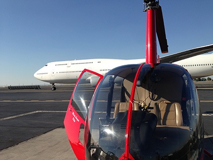
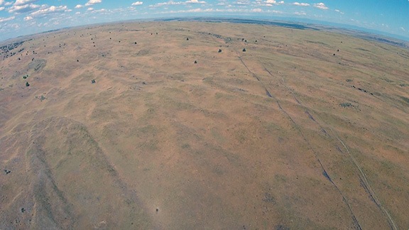
On what’s likely to be my last aerial photo gig here.

Penny wearing Earplugs
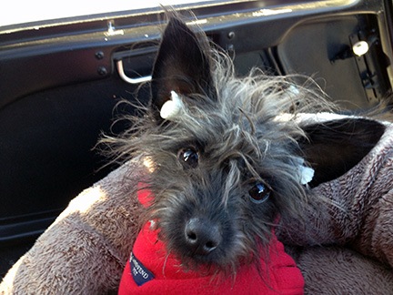
Penny with makeshift earplugs. They lasted about five minutes before falling out.

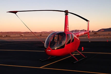
I flew my helicopter up to Lake Powell late this morning. With me for the ride (and the few days to follow) were a friend and Penny the Tiny Dog.

The Backstory

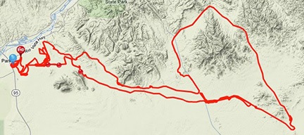
Way back in June, one of my good clients, Mike Reyfman, had booked three days of aerial photo flights with me starting January 1. He leads photo excursions for Russian photographers in various places throughout the world. I’m his Arizona/Utah helicopter pilot. I’ve flown for him on about a half dozen gigs since 2004: Lake Powell, Horseshoe Bend, Monument Valley, Goosenecks, Shiprock, and Bryce Canyon. Jobs last 2 to 7 days and involve 8 to 20 hours of flying. It’s good work not only because of the number of revenue hours I can fly, but because it takes me to some of the most incredible scenery in the southwest.

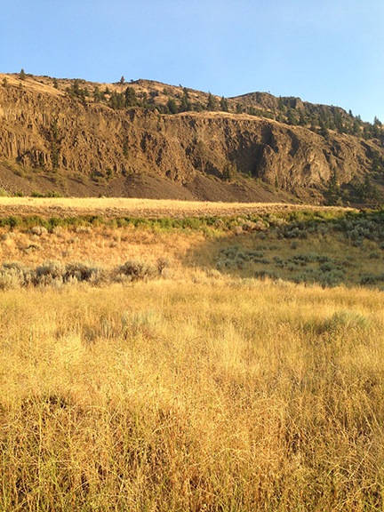
I had mixed feelings about the job. I wanted to go to Lake Powell again; it had been over a year since the last time I was up there. I own a hangar at the airport — purchased back when it looked as if I might do seasonal tour or charter work there — and I wanted to sell it. I needed to take a peek inside to see what the tenant had in there and then meet with a Realtor to get it listed. I also wanted to see the lake again. Over the past eight years — since buying my R44, in fact, I’d flown at least 200 hours at the lake, covering its length from the Dam to Hite at least a dozen times and even going as far as Canyonlands National Park two or three times. I’d worked with a video crew to make an aerial tour of the lake and was ripped off by the filmmaker, who disappeared with $26K of my money, leaving me with a hard disk of mediocre raw video and a hard lesson learned. (And no, I’m not interested in discussing this.) There’s no arguing that Lake Powell is one of the most beautiful places in the Southwest and the best way to appreciate that beauty is from the air.

But, at the same time, I was leery of winter photo shoots. Back in February 2011, I’d gone to Bryce Canyon for a 360° Panoramic photo shoot with this same client. A snow storm and cold weather had delayed our flight and made it damn near impossible to get the helicopter started when we were ready for the shoot. It required a gas-heater and generator under the helicopter’s engine compartment to warm the engine enough to crank it. The delay meant we couldn’t get out at first light as originally intended. When I checked the weather and saw freezing temperatures forecasted for dawn and dusk at Lake Powell, I remembered the Bryce Canyon problems and began worrying about a replay. Although my helicopter has a primer, no amount of priming will start that engine if it’s too cold. I also remembered another January photo gig up there and how cold it had been in flight. Those guys had kept me flying for about 3 hours — I even had to land for fuel at Cal Black Memorial halfway up the lake from Page. It was so cold that the back seat photographer had given up shooting and was leaning away from his open door as far as he could in an effort to keep warm. I never did like cold weather.

All of these thoughts were going through my head when I contemplated the job. But a revenue flight is a revenue flight and I had the possibility of being paid for 10 hours or more of flight time over four days at one of my favorite destinations. After losing at least $10K of revenue in Washington due to my early return, my inability to concentrate enough for writing jobs, and the huge sums of money I was paying my legal team to help me protect my business assets from the greedy, cheating liar I’d married six years before, I could really use the cash. So I convinced myself that I was glad about the work and prepped to make the trip.

Getting There

We flew up there around midday on New Year’s Day. The conditions were remarkably good. I’d flown through unforecasted low visibility and snowstorms on my way from Wickenburg to Winslow the day before, but there was none of that on Tuesday. The flight went well and I got a chance to show my companion even more of Arizona’s remote scenery from the air. This post with video gives you an idea of what we saw, although we weren’t flying from Phoenix so the actual route and views differ. (We got to see Sedona on our flight the day before.)

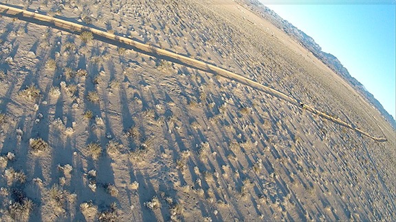
After a brief tour of Horseshoe Bend, the Glen Canyon Dam, and Wahweap Marina for my friend, we touched down at Page Municipal Airport. The folks from American Aviation were out to the helicopter with a van before my blades had even stopped spinning.

Penny Lounges in the SunPenny lounges in the sun under the desk in our hotel room.

We grabbed the rental car I’d arranged for, stopped at Stromboli’s restaurant for a huge calzone to share, and checked into the Days Inn hotel. The pet-friendly room was clean and well appointed with a king-sized bed, refrigerator, desk, free (and fast) wifi, and a sliding door that made it easy to take Penny outside. Best of all, it was on the south (sunny) side of the hotel, so the afternoon sunlight streamed in through the window, giving Penny that patch of sunlight she always seems to enjoy.

First Flight

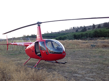
A while later, I was back at the airport. I had to prep the helicopter for the afternoon flight. That meant removing the two passenger side doors, adding a quart of oil, and laying out the life jackets. I make all my passengers wear flotation devices during photo flights over the lake. In more than a few places I fly there, an engine failure means a swim. I didn’t want anyone drowning because they couldn’t find or put on their life jacket.

Back in the terminal, Mike arrived with his group. He took one look at me and said he was seeing only 2/3 of me. I told him I’d lost only 20% of my body weight, not a third. I had already told him in email that the reason I had to lose weight was because he kept gaining it.

I gave his group a safety briefing. After each topic, Mike translated what I’d said into Russian. About half the group spoke some English and about half of those spoke it well.

I took the first group out to the helicopter: two photographers and a passenger. Normally, I won’t do a photo flight with three passengers on board, but the helicopter performs magnificently in cold weather, so it wasn’t an issue — even with nearly full tanks of fuel. They all climbed on board and I made sure they were strapped in. Then I started up the engine, warmed up, checked their seat belts one more time, and took off.

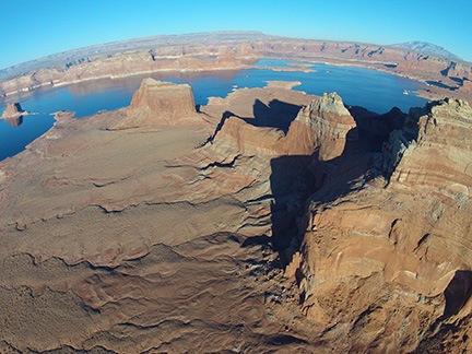
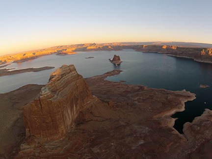
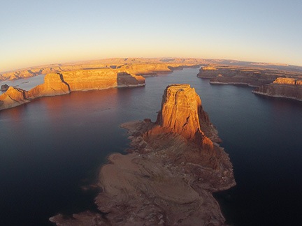
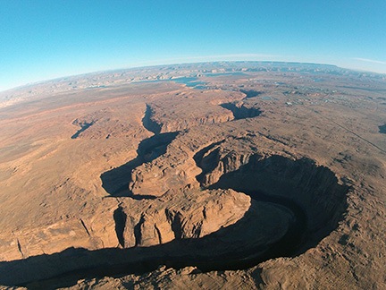
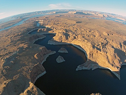
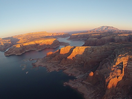
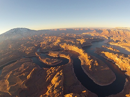
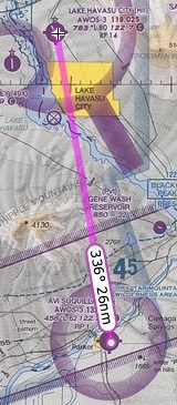
Mike’s instructions had been specific: start with Horseshoe Bend, which is near the airport. Then head uplake to Reflection Canyon, the San Juan Confluence, and an odd canyon I call “Canyon X” because of the way it looks from the air. Then back down lake to Padre Bay and Alstrom Point for a look at Gunsite Butte. So that’s what I did.

Oddly, when I first took off, I felt a bit hazy about the locations of all these points. It wasn’t until we were heading uplake, past Tower Butte that it all started coming back to me. Mostly it was the reporting points the tour pilots used. I’d learned these points so I understood where they were when they made their calls. I also used them so I could tell them where I was. Tower Butte, Padre Butte, Gregory Butte, Rock Creek, Dangling Rope, Rainbow Canyon. That’s as far as most of the tour planes went. I went a little farther, to the confluence.

Boundary Butte
At 3:56 PM, we were just passing the north end of Boundary Butte, heading uplake.

I flew uplake at about 5500 feet staying mostly over the river channel. The air was mostly calm and the water was glassy smooth in more than a few places, creating amazing reflections of the red sandstone cliffs. Just past Gregory Butte, the wind picked up a bit, ruining any chance of reflections on the lake surface.

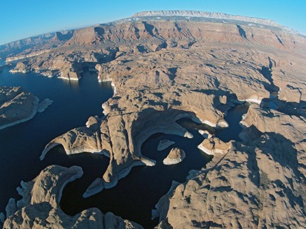
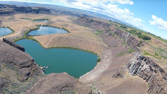
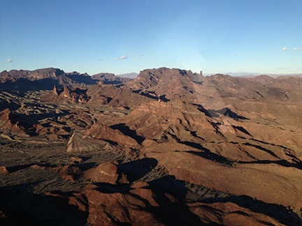
I reached Reflection Canyon — poorly named, in my opinion, because I’ve overflown it at least 100 times and have seldom seen any reflections there — at 5500 feet. I began a slow climb as I flew a racetrack pattern around the canyon, spiraling up in altitude. Our next destination was the twisting course of the San Juan River near its confluence with the Colorado and that was best viewed from 7000 feet or higher. When my photographers were finished with Reflection, I moved on to the San Juan and began circling it, spiraling up to 8500 feet as I circled it twice. Off in the distance, I could see the buttes in Monument Valley.

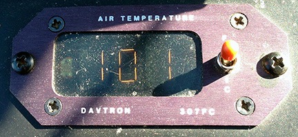
It was cold. The outside air temperature (OAT) gauge said -9. That’s -9°C, of course, or 15°F. I was wearing a pair of jeans and a long sleeved shirt under my leather jacket. I had a scarf and thin wool gloves on. Every part of me was cold. I hunched over the controls, trying to use my body to keep my body warm. I wasn’t succeeding. At times, my teeth chattered.

After the San Juan, I took them around Canyon X. Then we headed back toward Padre Butte. I was flying almost directly into the sun. I had a baseball cap on to offer some protection from the sun’s glare, but it didn’t help much. I kept at 6000 feet so I wouldn’t have to worry about flying into any buttes or canyon walls along the way.

East Side of Padre Bay
The east side of Padre Bay, shot from my helicopter’s nose cam from the south.

My passengers wanted to see the northeast side of Padre Bay, so we flew there first. I took them past Cookie Jar and the pockmarked rocks around it. There were some nice views of the canyon walls on the east side; my nose cam even got a nice shot. By the time we got to Gunsite, the sun was very low and the light had faded. The view wasn’t much to get excited about. My passengers had enough and we headed back.

We touched down at 5:20. The fuel truck was waiting.

Thawing Out

I was frozen solid. Or at least I felt as if I was. My right hand, which had been clutching the cyclic in a death grip, was probably the worst. I was shivering almost uncontrollably. I threw the doors back on the helicopter, locked it up, and headed back to the hotel.

It took me nearly an hour to warm back up.

Dinner with Russians
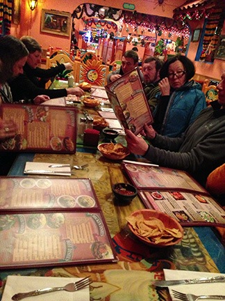
Mexican dinner with 11 Russians.

We went out to dinner at a Mexican place. If you ever want a weird experience, watch 11 Russians try to order Mexican food in English from a Mexican waiter. Dinner was good, but the portions were too large. Seriously: who needs that much food in a tourist town when you can’t even bring leftovers home? The bowls of soup looked as if they held a half gallon of the stuff.

Afterward, I went to Walmart to see if I could buy a pair of long johns and a turtleneck. I found a pair of leggings — the only pair in my size was brown. (Walmart offered all kinds of color options in sizes 2X and 3X.) I bought a few turtleneck shirts for the next few days.

Dawn Flight

The next morning, I layered my clothes: leggings under jeans and turtleneck under sweater under jacket. That should keep me warm, I reasoned.

I was out at the helicopter by about 6:45 AM. It was still dark, although I could see the sky brightening beyond the Navajo Generating Station. I took the doors back off and did a preflight with a flashlight. The quart of oil I’d brought into my hotel room overnight poured easily. I hooked up my GoPro with my skid mount so it would point the same general direction my passengers would be shooting. I drove the car back to the terminal building and parked it out back.

Ski Clothes
My passengers knew how to dress for freezing weather.

I greeted my passengers when they arrived at 7:20, got their life jackets on, and buckled them in. There were just two men. I realized that they were wearing ski clothes. They were Russians, accustomed to cold weather. And they were wearing ski clothes. You think that would have told me something.

I primed the engine a good ten seconds, pushed the starter button, and was surprised that the engine caught almost immediately. I fed it a little more fuel as I flicked the strobe, clutch, and alternator switches on. It sounded rough at first, but soon smoothed out. When the clutch light went out, I brought the RPM up to 68% and began the long wait for the engine to warm up.

While I waited, I used my laminated startup check list to scrape the frost off the cockpit bubble. I suspected that even in full sunlight, at 17°F and 90 knots for a wind chill factor of -14°F, it was unlikely to melt off.

When I was ready to go, I made my radio call and started pulling up on the collective to pick up. Immediately noticed that the collective was heavy. When I got it into a hover, I realized that the cyclic was extremely stiff. Almost — but not quite — as if they hydraulics weren’t working. I checked the switch; it was in the correct position. Circuit breaker was fine, too. I hovered a tiny bit hack and forth over the helipad. Stiff but not too stiff to fly. I assumed the hydraulic fluid was cold and that the situation would improve as it warmed.

Dawn Light
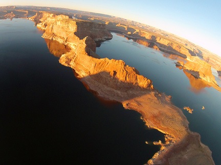
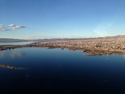
Padre Bay, by the dawn’s early light.

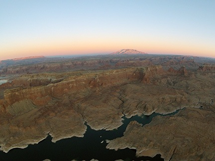
We took off just as dawn was breaking behind the power plant. We headed uplake at 5000 feet. As I flew, I admired the way the early morning light seemed to kiss the tops of the buttes and cliff faces.

Of course it was another perfectly clear morning. Some people might think that’s nice, but for photography, it sucks. The light gets harsh quickly and, without clouds and shadows, there’s little depth to the scenery. Besides all that, a clear blue sky is downright boring. But that’s part of life when doing photography in the desert southwest.

So we were racing uplake to the three target areas, hoping to get there and back to Padre Bay before the light got too bright.

Gregory Butte
Gregory Butte at first light with a view up Last Chance Bay.

It was another beautiful flight — and I can prove that with hundreds of photos. Honestly, I’ve seen so much of Lake Powell from the air during the “golden hours” that none of the photos really impress me anymore. It has to be one of the most beautiful places on earth and there’s no better view than from a helicopter at dawn.

My passengers wanted me flying higher, so I climbed to 6000 feet. I was freezing cold again before we got to the San Juan Confluence. I started doubting the wisdom of doing these flights. And started wondering how many layers of clothes I needed to wear to keep warm. My hand on the cyclic seemed frozen solid. And my feet were freezing, too. But I kept flying, knowing that when the light got too harsh, we’d be done.

I circled each target area two to three times as instructed. My photographers snapped dozens of photos. I’d glance at them occasionally and see them moving their cameras in every direction, framing up their shots. Occasionally, the one who spoke English — and he spoke it very well — would give me instructions. But in general, they let me do what I liked.

When they were finished with the uplake target areas, we headed back down the lake. Along the way, they stopped me to photograph several other places where the light was hitting just right. All I could think about was how cold I was and how much I wanted to be on the ground.

Horseshoe Bend
Horseshoe Bend from the south. The narrow canyon is usually full of deep shadows.

We finished up with Horseshoe Bend, which is best photographed when the sun is high. News flash: the winter sun is never quite high enough to photograph Horseshoe Bend without deep shadows.

Warming Up Again

We were on the ground by 9:20 AM. Shutdown went quickly; the engine had cooled considerably on my approach. I felt frozen and was shivering badly when the fuel truck pulled up to fuel us. My feet felt like stumps as I joined my passengers for the walk back to the terminal.

I left the doors off the helicopter and drove back to the hotel, stopping at McDonalds for a quick bite to eat and a more important glass of orange juice. I was shivering the whole time. In fact, it took me a full hour and a half to stop shivering. Then I stretched out on the bed and fell asleep. I didn’t wake up until after 1 PM. That had me really worried — I never sleep like that in the middle of the day. I was certain I was coming down with a cold.

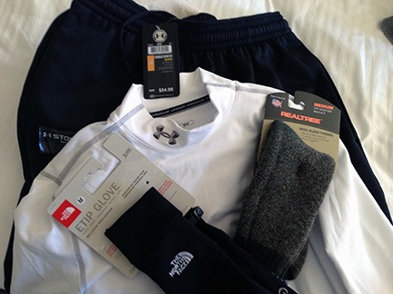
With at least two flights left to do, I needed warmer clothes.

Armoured
My “armour” against the cold.

I headed out to a sporting goods store I found near Safeway. The saleswoman there set me up with some Under Armour. I didn’t care what it cost. I bought a shirt, a pair of pants, and a pair of gloves and left $180 with her. Then I headed back to Walmart and found a pair of thermal socks in the sporting goods department.

We hit Sonic for lunch and had another big glass of orange juice. We had a nice little walk with Penny while we waited for the food.

Then I went back to my room to dress all over again. Three layers of shirts under my leather jacket, 2 layers of pants, the thermal socks. I’d put the new gloves on before taking off.

I made it back to the airport by 3 PM, in time to prep for my afternoon flight.

Third Flight

My passengers were late and slow about getting on board. As a result, we didn’t take off until after 4 PM. This turned out to be very unfortunate for them.

Navajo Canyon
Navajo Canyon, from the south. Although the canyon walls are not very high here (compared to Horseshoe, anyway), there were already deep shadows.

Like the previous afternoon’s flight, these folks wanted to start with Horseshoe Bend. I thought it was a waste of time, but doubted whether they’d believe me so I kept quiet. We circled Horseshoe Bend twice, then headed uplake. Along the way, they caught sight of the pair of islands in the middle of Navajo Canyon and instructed me to circle them. I did that twice. It wasn’t until 4:28 that we continued heading uplake.

I was cold. Still. I realized that the gloves I’d spent $25 on weren’t much better than the junky gloves I’d worn on the previous two flights. I tried to put another glove over the one on my right hand, but couldn’t manage it while holding the cyclic. I was able to jam my left hand under my leg or between my legs to keep it warm. Occasionally, I’d wrap my left hand around my right hand on the cyclic in an attempt to warm my right hand. I don’t think it worked. My body was warm enough but my legs were not. My feet were nice and toasty — at least my $6 Walmart socks were doing their job. Overall, however, I was definitely warmer than I had been on the previous two flights.

Canyon X and Reflection Canyon were already in deep shadows when we got there 15 minutes later. Even the twisting course of the San Juan River was in shadow — although there were some decent reflections there. I circled and climbed and circled and descended. When I got the word, I headed back down lake.

By this time, it was after 5 PM. Sunset was 5:20. It would take at least 15 minutes to get all the way down to Padre Bay, the next target location. But I’d noticed on the previous day’s flight that the sunlight was already too soft to really show off the red rock glow by 5:10. My passengers were running out of light and there was nothing I could do.

Mouth of Rock Creek
The cliff faces across from the mouth of Rock Creek were nicely illuminated in the last light of the day.

Of course, since we were flying into the sun, my passengers could see it just as well as I could. I think they realized that we wouldn’t reach Padre Bay in time. So they had me circle a few areas that were still illuminated, like the cliffs across from the mouth of Rock Creek.
“Very dramatic,” my front seat passenger said. I couldn’t argue.

West Canyon
By the time we reached West Canyon, only the highest points — like Navajo Mountain — were still in sunlight.

After that, we tried to check out the area south of West Canyon. This area is normally outrageously beautiful in last light, but often overlooked by photographers who concentrate on the cliffs and buttes around the lake. But by that time, only the highest points still had light on them. I watched the sun’s orange globe sink below the horizon in the west.

“Go back?” I asked my clients?

“What is our choice?” the English speaker replied glumly.

I didn’t tell them that another photographer had once kept me out nearly an hour past sunset at the lake — so late that I needed my landing light to find the helipad. Instead, I just headed back.

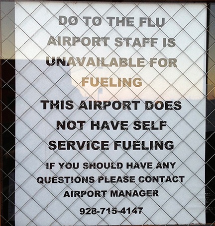
Back on the ground, I walked them to the terminal. It was locked. The fuel guy was gone and my doors were inside the building. I helped them get through the gate, then drove around to the front of the building. A few people were still inside, so I was able to retrieve my doors. But no chance of getting fuel. Unless I was willing to pay a $50 after-hours callout fee — which I was not — the next morning’s flight might be a lot shorter than desired.

Talking My Client Out of Flying

I buttoned up the helicopter, grabbed a quart of oil to heat in my room overnight, and went back to the hotel.

I was cold and I didn’t want to fly any more than I had to. I was worried about getting sick.

I called Mike and told him about the fuel situation. I told him I thought we had enough for about an hour and a half in the morning. Then I talked to him about the second part of our photo gig: the Goosenecks of the San Juan, which is near Mexican Hat, UT. I had two logistical problems.

First, I didn’t have a landing zone less than 15 minutes flight time from Goosenecks. The only good landing zone was at Goulding’s Lodge, a private runway. That means that each flight would likely take 45 minutes to an hour.

Second, the closest fuel was at Cal Black Memorial Airport on Lake Powell, about 20 minutes flight time from Gouldings or Goosenecks. That meant a 40-minute refueling run.

Mike, of course, had to pay for all of my flight time. He could do the math as well as I could. It would likely add 4 to 5 hours of flight time if he decided to move forward on the Goosenecks flights. He said he’d talk to the photographers and see what they wanted to do. We hung up and I crossed my frozen fingers that they’d pass.

Fourth Flight

I was back at the airport at 7 AM the next morning, prepping for my flight. Since the fuelers for Classic Aviation were already there, I ordered fuel from them, topping off the tanks.

Frost on the Bubble
Frost on the bubble.

I repeated the previous morning’s routine, although I did scrape the frost off the bubble before my passengers arrived. There was a lot more of it. Later, when I returned, I’d still see tiny piles of the stuff on my helipad, where it had stuck to the ground but failed to melt.

I had three passengers: two photographers and an observer. They were all women.

I lifted off at 7:50 AM, 11 minutes after sunrise. The controls were so stiff that I was almost certain the hydraulics had failed. I set it back down, tested the controls, and realized that it was just the cold again. Worse than the day before. I decided to give it a go; I could always turn around and come back. Fortunately it was operating normally within 5 minutes.

Canyon X
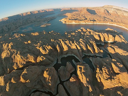
An early morning view of what I call Canyon X, from the air.

San Juan River
An aerial view of the San Juan River near its confluence with the Colorado at Lake Powell.

Reflection Canyon
Reflection Canyon from the air.

In my opinion, this flight had the best light along the way. The sun was high enough to illuminate the rock faces, but low enough to cast shadows that added depth to the scenery. And the light was soft and red — just perfect (in my opinion) for photographing the lake. Indeed, my uplake skidcam images are better from this fight than any other.

And because we’d gotten a later start than the previous morning, there was also better light on our target areas. Canyon X, for example, had lots of interesting light and shadows. The twisting course of the San Juan River seemed to glow in the morning light. Even Reflection Canyon was more interesting than in previous flights. There were even some reflections down there.

Because we weren’t racing to beat the sunset, the flight was more relaxed, too. Sure, the light wouldn’t be as “good” later on in the flight, but it wasn’t as if we’d run out of light. So we took our time and circled each point as many times as necessary. Stress free.

I was still cold, of course. I’d layered up a little better and was wearing two pairs of gloves. My hands and legs were still cold. I was not looking forward to the prospect of more flights that afternoon out near Monument Valley.

After finishing up near the Confluence, we headed back toward Padre Bay. We did a few circles in the area. The light was nice, but the golden hour was nearly over. They wisely decided to skip Horseshoe Bend.

We were on the ground by 9 AM. I didn’t hang around. I got into the rental car and headed back to the hotel to pack.

Finishing Up and Heading Out

Mike called when I was halfway finished packing and sucking down yet another orange juice. He came by the hotel to pay for the flights. Fortunately, he’d decided to skip the Goosenecks flights. I was relieved. I’d pretty much decided to say no and was wondering how I’d tell him. Now I didn’t have to.

Mike paid for the flight time and we said our goodbyes with a hug. It would likely be the last time we worked together. I was moving to Washington State and, unless he wanted aerial tours of the Palouse (another one of his destinations), he’d have no need for a helicopter in my area. I was sad to see him go.

Later, I met with a Realtor at the hangar I need to sell. We discussed terms and I was not happy to learn that an agreement with them would require me to pay them a commission even if I sold the hangar on my own. I still don’t get the logic in that.

We were loaded up — with the doors on! — and ready to depart by 12:45. I was really looking forward to getting home.

Little Colorado River Gorge
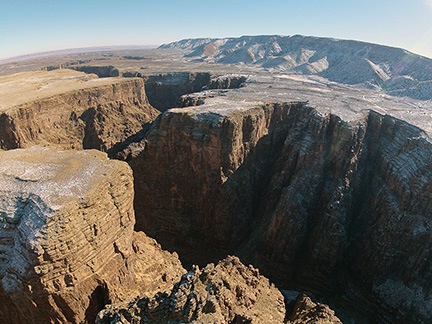
The Little Colorado River Gorge from about 200 feet above the rim.

The flight back was uneventful. I did a straight line to the Little Colorado River Gorge, which I flew over rather low to get a dramatic shot with the skidcam. Then I straight-lined it to my Howard Mesa property, which I always fly over when I’m in the area. From there, a straight line to the west side of Granite Mountain near Prescott and then a straight line to Wickenburg Municipal.

As I was coming in, a friend of mine from my Papillon days back in 2004 was leaving on a Game and Fish survey job. We spoke briefly on the radio; he’d join us for dinner later that evening.

I was glad to get the helicopter tucked away into the hangar and even gladder to be in my truck heading home. I was looking forward to at least a few days without travel — and even longer without freezing cold.
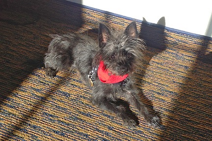