I get to see my first (and likely only) total eclipse of the sun. And do some other stuff.
– Day 1: Packing and Heading Out
– Day 2: Finding the Perfect Spot
– Day 3: The Eclipse and More
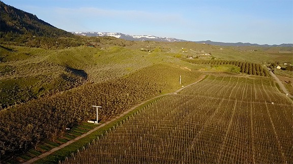
– Day 4: The Travel and Wine Tasting Day
– Days 5-7: The Palouse, Spokane, and Lake Roosevelt
I slept until 5:30, which is really unusual for me. It was quite light out, so I missed my chance for nighttime photography. At least there.
Prepping for the Eclipse
I made coffee and spent some time preparing my cameras for shooting the eclipse. I had my Nikon D7000 with me, along with a 70-300mm Nikkor lens and a solar filter I’d bought to fit it. I’d already experimented with the filter and was satisfied that it enabled me to shoot pictures of the sun without worries of damaging the camera’s sensor. That camera would go on my heavy duty Manfroto tripod, forming my main photographic platform.
I also had a GoPro with me. I thought I’d try using that for a time-lapse. I took a spare pair of eclipse glasses and cut the plastic lens from the cardboard frame, then taped it over the GoPro lens. I had to do this on the outside of the lens case; I couldn’t get it inside. I then set it up where I could get a time-lapse of the sky. I had serious doubts I’d get anything worth keeping.
I also had my iPhone and I made a lens filter for that. Again, I wasn’t happy with the images I got, but it was worth a try.
I did some research with the Observatory app I have on my iPad to get an idea of when all this would begin. I then looked up exact numbers for my location using the PhotoPills app I just got. That said the eclipse would start at 9:09 AM. Less than three hours away.
I spent the next half hour cutting up veggies and browning meat to start a beef stew. I figured that since I had to hang around all morning, I’d put that time to good use. The stew had stew meat from the 1/4 cow I bought last year, onions, carrots, potatoes, zucchini, and tomatoes. These last three came from my garden. Once everything was browned, I added salt and pepper (the only appropriate seasonings on hand) and a pint of beef broth that I’d made last autumn and froze. (Honestly, I’m doing everything possible to clear out my freezer.) I put the cover on and let it simmer.
By this time, it was after 7 AM and most of my eclipse “family” (as Jay called us) was up and about. The three guys who had come up from the San Francisco Bay area the day before were already cleaning out their tent. Jay and his brother, the birthday boys, were having coffee. I walked over to wish them a happy birthday. Only the motorhome people were still locked up in their metal box — all five of them.
I took this sample photo early in them morning with the sun through the trees. I guess I was just testing for exposure.
I set up my cameras outside. I took a sample photo of the sun shining through the tall firs on the edge of our camping area. I sacrificed another spare pair of my eclipse glasses for the three guys in the tent to make solar filters for their smartphones.
I should mention here that it was an absolutely perfect day for eclipse viewing. There wasn’t a single cloud in the sky. The air was clear — not the least bit hazy or smokey. There was virtually no wind and the temperature by 8 AM was in the high 60s/low 70s. We were right on the line for maximum totality. There was nothing that could be changed to make the weather or our position any better for eclipse viewing. Nothing.
I flew the drone for a while, taking it down the road for a view of all the Four Corners campers. There were a lot more than there had been the previous afternoon. I flew it over by Jay’s camp where Jay, not knowing I was flying it, flipped the finger at it. Oops. I landed it and put it away.
And then I waited with the others.
The Eclipse
Before I go any further, I need to apologize for not being able to adequately describe the experience of seeing a total solar eclipse with my own eyes. Simply said, it’s awe-inspiring and probably the most amazing thing I’ve ever witnessed. When totality was all over, I was left feeling stunned by the magnificence of what I’d just seen and very sorry for the people who had passed up the opportunity to see it for themselves.
That said, I’ll do my best to describe it.
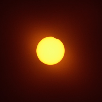
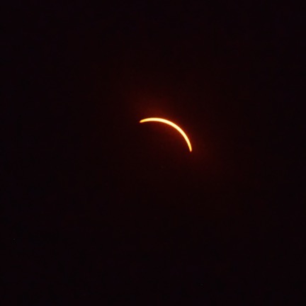
I do need to point out that even though the photos that follow show a black sky, the sky was bright blue until totality. The photos where the sun looks orange were shot through a solar filter, which basically makes everything except the sun black. Keep that in mind as you view my contribution to the photo library of eclipse photos.
One of my companions referred to this as “first bite.” Can you see the shadow of the moon in the upper right corner?
I was watching the sun, though my eclipse glasses, when 9:09 AM rolled along. For some reason, I thought the moon would approach on the lower left of the sun. (In hindsight, that makes no sense. My Observatory app had told me that the moon rose a few minutes before the sun that morning and the sun’s motion through the sky is slightly faster than the moon’s. That meant the sun would catch up to the moon and pass behind it relative to our point of view on earth.) So when I thought I saw a tiny change in the upper right side of the sun, I had to confirm with a look through my filtered camera lens.
“It’s starting!” I called out.
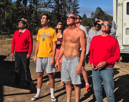
The motorhome gang and their tent-lodging friends, looking up at the eclipse with their eclipse glasses on. (And yes, they did pose for this.)
One by one, my companions put on their eclipse glasses and looked up at the sun. There was some debate and then someone confirmed it. That’s when I mentioned that they could see it better through my camera which was, in essence, acting like a low-powered telescope. That’s probably when my camera became the central viewing area for me, the motorhome people, and their three tent-camping friends. There was barely a minute for the next hour or so that someone wasn’t looking through the viewfinder.
Meanwhile, across the little road that separated us from Jay’s group, Jay had set up a pinhole viewer with a mirror that projected onto the front of his pop-up truck camper. That’s how he was watching the eclipse progress. He’d read somewhere that even looking through eclipse glasses could be harmful to your eyes if you do it too long. So he wasn’t doing it much at all. I think he was there for totality, the two minutes and twenty seconds when you could look at the eclipse without eclipse glasses on.
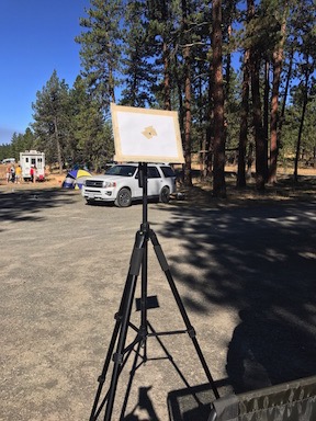
Jay, a retired teacher, created an eclipse projector and displayed it on the front of his camper.

I figure the sun was about a third covered in this shot. Without eclipse glasses on, it was still bright sunlight all around us.
I snapped a photos with the camera periodically as the moon’s shadow progressed across the face of the sun. The sun looked like an orange disc with a black disc held against it. I had to reposition the camera on the tripod every 5-10 minutes because the sun and moon kept moving up and to the right in the sky.
I tried shooting images with my iPhone but they looked like crap. Behind us, my GoPro had been snapping away since before 9 AM, taking one shot every 20 seconds. I had no idea what I’d wind up with.
Then I had the idea of using my binoculars in conjunction with the eclipse glasses. I had to hold the glasses over the side of the binoculars facing the sun. Then I’d raise them to my eyes and pivot my head toward the sun. The tricky part was finding the sun — eclipse glasses make everything except the sun completely black. You can’t peek while you’re doing this. You have to point your body towards the sun’s warmth until the sun pops into view. It was worth the effort. I was able to get an even better view of the sun and even saw a series of three sun spots in a line, like Orion’s Belt on the sun. These spots don’t show in any of my Nikon photos, but I think it’s the exposure that hid them.
This part of the eclipse took a long time. In the movies, it seems like it all happens really quickly, but it doesn’t. It took more than a hour from the start at 9:09 to totality at around 10:20. For the first half of this time, there was basically no change in the sun’s light. It was still a bright, warm sunny day. With the glasses off, not looking at the sun (of course) you wouldn’t even know an eclipse was happening unless you were paying really close attention to your surroundings.
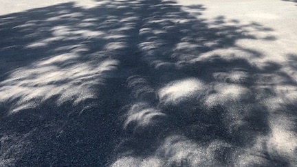
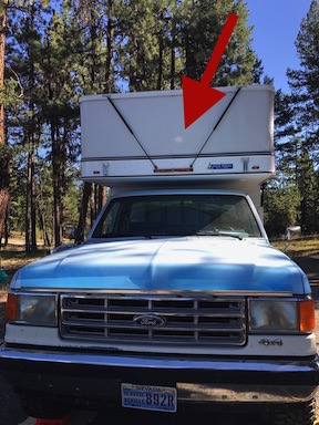
Shadows cast by the trees near Jay’s camp appeared as scallops in the road.
The first hint that something was amiss was the way the shadows changed. The area we were in was surrounded by tall fir trees. As the moon hid at least 50% of the sun, the shadows took on a crescent shape, like scallops. This was particularly noticeable near Jay’s camp and we all went over for a look. I recalled seeing shadows like this one day when I lived in New Jersey back in the 1990s. There had been a partial solar eclipse where I lived and I didn’t even know about it until I saw the shadows change. Not having any way to safely view the sun, I never saw the eclipse itself or learned how much of the sun was obscured. (Note to self: Google this.)
Amir of the motorhome was the first to notice the temperature change. I had a crappy weather station thermometer with me, but being crappy, it couldn’t keep up with the change and provide accurate readings. He claimed to be very sensitive to temperature changes. Wearing shorts and a tee shirt, he and his wife donned sweatshirts before totality.
The atmosphere in the camp was festive. We didn’t spend the whole time staring at the sun. It really did happen slowly. I just took periodic photos and kept my camera pointed the right direction so others could look. One person claimed to see the jagged edges of the moon’s surface against the sun. Only a few of us saw the sun spots, which were best visible through the binoculars.
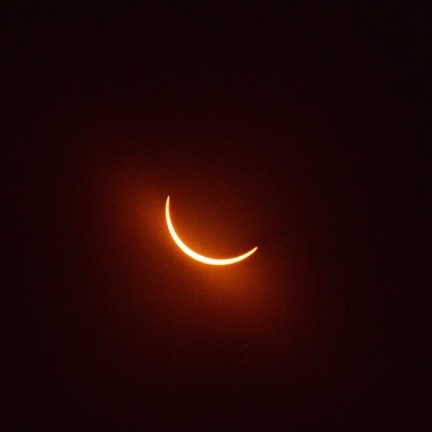
At about 90-95% eclipsed, the sun looked like a crescent through the eclipse glasses, but it was still very bright all around us.
Excitement in the camp grew as the moon covered 90% of the sun’s disc. This is what I would have experienced if I’d stayed home. It was still very bright outside, but the light had taken on a weird characteristic that I can’t really explain. Was the color different? Maybe a little blue? Or flatter? I can’t explain it. It was just weird. And the temperature change started to become obvious.
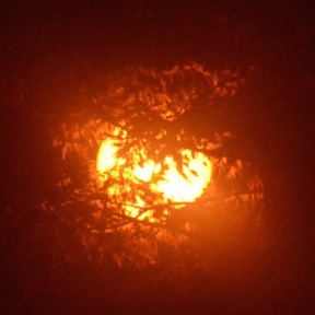
I was watching with my eclipse glasses when the sun slipped completely behind the moon. Everything went black as the people around me started hooting with glee. I pulled off the glasses and looked up. And there, in the sky, was a total eclipse of the sun.
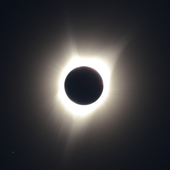
A total eclipse of the sun, as documented by my Nikon camera with 300mm lens and no solar filter. The sky was this dark. Can you see the star in the lower left corner of the photo? Venus, which was in the upper-right outside the camera’s field of view, was much brighter.
It was amazing. How can I explain it other than to say that it looks exactly like the photos? There’s what looks like a perfectly round black void in the sky with a halo of white light radiating from it. It’s completely surreal.
But what’s really amazing is how quickly the light around us is snuffed out in the final 60 seconds or so before totality. One minute, it’s daytime with a weird blue-gray light and a blue sky. The next minute, it’s as dark as a night with a full moon and the sky is black. (I can easily imagine how it must have terrified ancient people who didn’t see it coming.) And yes, I saw stars. Venus was a bright light up ahead of the sun’s path in the sky.
In the two minutes and twenty seconds of totality, it was hard to make all the observations I’d heard suggested. I couldn’t tell if the wildlife was quiet, mostly because all of us were talking about what we were seeing. I didn’t dwell on how dark it was or how the temperature changed because I was too focused on that haloed void in the sky. I barely had the presence of mind to take a few photos. (And yes, I know I can see eclipse photos anywhere, but it’s different when it’s from my own camera — documentation of something I personally witnessed.)
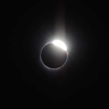
I was pleasantly surprised to see that my camera had captured the “diamond ring” effect in the very last shot before I put the solar filter back on.
Here’s one of the photos I took after totality. I have a bunch of others, too. I’ll likely fiddle with them in Photoshop when I get home to make some sort of sequence.
Across the little road, Jay was calling out the time. He wanted to make sure we all had our glasses on before totality ended. I think we all stared until the sun told us because all of a sudden it was bright again and we had to look away. Glasses on, I looked back. The sun had continued moving beyond the moon. Totality was over.
As quickly as the sunlight had disappeared, it was back. Within minutes, I could feel the sun warming the air around me. Fifteen minutes later, only the weird shadows remained to indicate that there was anything amiss with the sun. Over the next hour or so, I shot a few more photos. But as we all went about our business, we lost interest in the final moments of the eclipse. Even I missed the moment when the moon’s shadow left the sun behind.
Post Eclipse
What was weird to me was that within minutes of totality ending, people around Four Corners Camp started to leave. It was like being at a ballgame at the bottom of the ninth inning when the home team isn’t likely to catch up with the visitor’s lead. Hurry up, get out, beat the traffic. Very strange.
After watching the waning eclipse on and off for a while, I went into my camper and dished out some of the stew I’d started that morning. It was excellent; the meat was very tender and the veggies tasty. It was around 11 AM and it was the first thing I’d eaten all day.
Amir began fiddling with the bladder tanks he’d installed on his motorhome to increase the amount of fresh and gray water he could carry. He came over to explain what he was up to and why. He’d had the motorhome for about a year and had made some modifications so it would be better suited to off-the-grid use. A engineer who had recently sold his business, he had the knowledge and time to fiddle around and make improvements. We talked for a while about how RVs were so outdated and how much technology could improve them. It was refreshing to talk to someone with good ideas who could think outside the box and was willing to implement them.
While we chatted, his wife came over with a plate for me. “I made you a breakfast burrito,” she said before I could turn it down. “Come inside and eat with us.”
So Penny and I went into the motorhome and took a seat at the table with the rest of the gang. The breakfast burrito was eggs with chopped up leftover hamburger wrapped in a flour tortilla with guacamole and salsa. Tasty. One of their sons fed Penny about half a leftover hamburger while we talked about their travel plans. I told them about Quartzsite. I wouldn’t be surprised at all if I see them there next January.
By the time I got back outside, the eclipse was long over and about half the area campers were gone. The three tent guys had left before breakfast; they were aiming for Reno, where they’d spend the night before driving back to the Bay area. Tents that had been set up in the field and RVs that had been parked along the road were gone. The population of Four Corners Camp had been cut in half in less than two hours.
I turned off the GoPro and removed it from where it had been mounted. I shifted my solar panel to point more directly at the sun. Then I brought my camera inside and spent some time cleaning up and doing the dishes.
It wasn’t until much later that I’d look at the GoPro photos. As I expected, they were pretty bad and not worth sharing. Oh, well.
Amir and his family left a while later. They were also headed to Reno but would spend the night at John Day, taking care of some motorhome issues. Apparently, the water heater wasn’t working and Amir’s wife was eager to take a shower.
I visited with Jay and his friends. We chatted for a while. I asked him if it was everything he’d expected — after all, he’d told me that he’d planned the trip eight years before. He said that it was. But, at the same time, he seemed sad — maybe because this long-planned event was behind him? I asked how long he was staying at the camp and he replied that no one had told him when it was time to leave. We agreed that it was nice to live life without someone else telling us what to do. He was new to retirement and apparently liking it a lot.
Back at my RV, I put the finishing touches on my Day 1 blog post. Through many tries with a patchy connection, I managed to get it posted on my blog. Between upload attempts, I wrote up Day 2 and then managed to get that online. By then, it was after 3 PM.
I took out the map and tried to make a plan for the next 12 hours. I really wanted to hike around Magone Lake and I thought a late afternoon hike would be a good idea. There was a slight possibility that some campsites there may have opened up for the night. But I didn’t really want to stay in the area. Instead, I wanted to be on my way. I thought that it might be neat to camp out near the fire tower at Ritter Butte and I remembered the big parking area full of campers that I’d passed the morning before. That might be a good destination for the evening.
Plan made, I started to put it in motion. I broke camp by putting away the solar panels and my grill and cleaning up the inside of the camper. By 4 PM, I was ready to go. I walked over to say goodbye to Jay and his friends and to thank him again for allowing me to be part of his eclipse family. Then Penny and I went back to the truck and drove off.
Very few campers remained at Four Corners Camp.
Magone Lake
Magone Lake was eight miles from Four Corners. It took about 20 minutes to get there on the gravel and then narrow paved road. I parked at the boat launch parking area, which was surprisingly active for a Monday afternoon. It seemed that a lot of people had decided to come for more than just the eclipse. It was great to see so many people in the water swimming and paddling around in kayaks — especially families.
One of the great things about the area is that with no cell service, people can’t spend all their time focused on a phone screen.
One of the photos I shot during our hike. I am such a sucker for reflections.
I put Penny on a leash, set up GaiaGPS on my iPhone to record a track — even though I had no map of the area — and set out on the trail that looked like it went around the lake. We went clockwise, walking in on the shady west side of the lake past the picnic area and campground first. There were other hikers, some with dogs, who we passed along the way. The trail was narrow but well-worn and became paved for handicap and stroller access at the picnic area. Past the campground, where it crossed dry feed stream, the pavement ended again. I let Penny off her leash to run ahead of me as she usually does. I kept a brisk pace, stopping once in a while to take a photo. The lake was pretty the way so many mountain lakes are, but my camera couldn’t seem to capture that beauty.
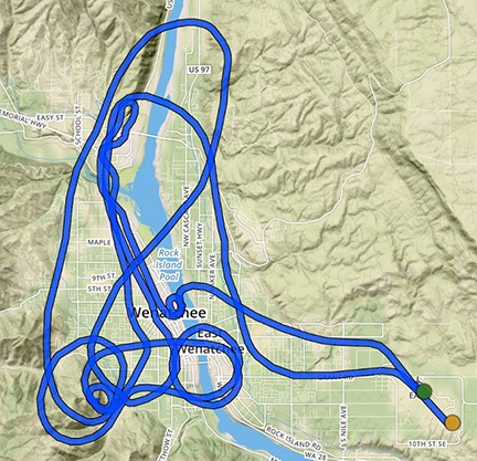
I worked up a bit of a sweat on the sunny side of the lake, which was good for me. I haven’t been nearly as active in the past year or so as I should be. I need a good workout once in a while. Within 45 minutes, we were back at the parking area. GaiaGPS told me we’d hiked 1-3/4 miles. (you can check out our track here.) Not bad, but certainly nothing to brag about.
I consulted the Oregon map I had with me, trying to determine how many miles we were from Ritter Butte. I wavered on spending the night at the lake. I really did want to start driving north, though. My rough plans included a day of wine tasting in Walla Walla and some night photography at Palouse Falls. I had to be home by Friday evening for a charter flight on Saturday. Spending the night at Magone Lake meant a longer drive the next day to Walla Walla. I was hoping to make it a scenic drive and didn’t want to arrive in town too late to stop at a winery or two. That meant putting some miles behind me before nightfall.
So we left the park, tracing our route back on the narrow paved and then gravel road northwest to Long Creek. Just about all the campers I’d seen the day before were gone. We emerged from the forest and drove the last few miles to Long Creek, where we turned north on route 395. Eight or nine miles later, we were at the turn for Ritter Butte.
All of the campers who had been set up there the day before were gone. I turned left, noticing the preponderance of “No Trespassing” signs that looked brand new. I was very disappointed to see one at the turn for the road that went up to the fire tower.
With a 5-bar LTE signal, I used my iPad to look up the Ritter Butte Fire Lookout. Every reference I saw said it was open to the public. Yet here were the signs saying it wasn’t. What was I to believe? I chose the signs. I turned around.
The parking area that had resembled a cosy camp the day before looked more like a gravel parking lot in the late afternoon light. I imagined camping out while cars and trucks zipped by throughout the night. I turned north on Route 395 and kept going.
I figured I’d camp out at the campground that had been full on Saturday night. Surely there would be space on a Monday night. But I didn’t get that far. After driving at least 20 miles, I reached the turnoff for Olive Lake, where I’d been told there were place to camp. That was still 20 miles south of the campground I was shooting for. With sunset on it’s way, I made the turn. Five minutes later, I was pulling into a creekside campground with only five sites, one of which was empty. I backed in for the night.
To give you an idea of how small this campground is, the canopy of trees over the entrance was so low that I know my camper pushed them aside as we rolled in. I also know that there’s no way in hell I could have made the entrance turn, let alone the turnaround at the end, with my old fifth wheel. My truck camper was the only RV in the place — everyone else was camping in a tent. My next door neighbors had two cars and three tents, including a shade tent, crammed into their site. The best site, which was a big one at the far end, was occupied by a young guy in a compact car with a small dome tent.
I settled in, made some dinner, ate, and then walked back out to the entrance to pay the $8 fee. My next door neighbors were eating something that smelled really good. We exchanged a few words before I went back into my camper to start this blog post.
It was getting dark by 8:30 and I moved up to lounge in my bed, where I spent some time reading my eclipse book. Soon I was falling asleep. I killed the light and was sound asleep in minutes.