Flight to Sky Harbor…at Night

A pickup at the Terminal 3 helipad.

Last week, I had my first passenger pickup at Sky Harbor’s Terminal 3 helipad. This was an unusual gig for several reasons:

  • I’d only flown into the Terminal 3 helipad once before, and that was with a flight instructor. I’d asked for the flight so I could learn the approach in case I ever had to do it. A full year went by before I had a call for a pickup there.
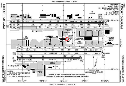
  • The Terminal 3 helipad is on top of Terminal 3 (hence the name), in an area that’s in the middle of the top level of a parking structure. To reach it, you have to cross one runway (from the north) or two runways (from the south) where commercial airliners are landing and taking off. (The airport diagram below shows its location beside the Control tower in the middle of this busy Class Bravo airport.)
  • This particular pickup was at 8 PM. Since it was February, that means it was night.

Sky Harbor Airport Diagram

So I was going to land at a helipad I’d landed on only once before, at the top of a 6-story building, in the middle of busy airport, at night.

The terminal 3 helipad is far more convenient for my passengers than where I usually land on the southwest corner of the airport at one of the FBOs. (I usually use Cutter, but Swift is there, too.) Landing at an FBO requires my passengers to get a free shuttle from their terminal to the FBO. You can’t beat the cost, but the amount of time you wait for the shuttle and then ride it takes away from the convenience of being picked up at Sky Harbor and whisked to your destination. My passengers were arriving via U.S. Airways (formerly America West), which had gates at Terminal 4. They’d still need to take a shuttle to meet me, but at least they didn’t have to go around the airport to do it.

The Flight

My passengers were supposed to land at 8:07 PM. I figured that by the time they got to the gate and retrieved their luggage, it would be at least 8:30. Then at least 15 minutes to get to me. Still, I don’t like to make people wait for me, so I decided to get there by 8:15 PM. That means I needed to start up at Wickenburg Airport by 7:30 or so.

Mike dropped me off. I’d pulled the helicopter out and fueled it up earlier in the day so it was sitting on a helipad, ready to go when we arrived. There was still a little glow to the west where the sun had set. Mike waited until I took off. Our friend Dave pulled up in his Jeep and chatted with him while I warmed up the helicopter. Then I took off, turning on the runway lights as I lifted off. I climbed to 3,000 feet and turned to the southeast where I could see the glow of Phoenix.

Route to PHX
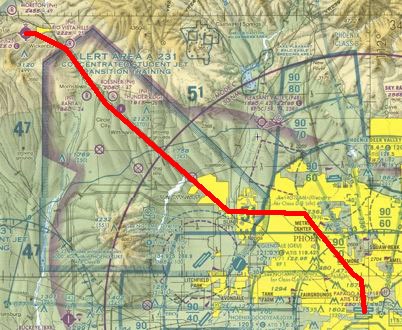
My flight path would take me from the darkness of Wickenburg along Route 60 (Grand Avenue) to Bell Road. By then, I’d be in the brightness of the Phoenix area, flying at about 2,000 feet in over its lower elevations. I planned to turn east along Bell Road and follow that to I-17. I’d call Phoenix Tower from the Metro Center Mall at I-17 and Dunlap.

Yes, I follow roads.

The flight worked just as I intended, although I did have to head southeast toward the mall sooner than I expected to avoid Deer Valley’s airspace. It wasn’t worth calling them for the 3 minutes I’d be in their space, so I just avoided it. My GPS made it easy to see where the space was so I didn’t slip in by mistake.

I’d been listening to Phoenix Tower talking to the incoming airliners since I was 20 miles out. I had nothing else to listen to. I’d purposely left my iPod behind so I wouldn’t be distracted by it. I don’t fly at night that often — maybe once or twice a month — and I was nervous about flying into the helipad at night.

Don’t think you can recite what I’ve written here to land at the T-3 Helispot. In March 2012, the tower management at PHX realized that a lot of pilots were claiming they were signatories to the Sharp Echo letter of agreement when they, in fact, were not. As a result, they instituted a new letter of agreement and required all signatories to attend a meeting at the tower. If you plan on operating a helicopter in the Phoenix Class Bravo airspace, you need to meet with Phoenix tower management and get signed up with the new letter of agreement to take advantage of the options it offers pilots.

I tuned my transponder to 0400. “Phoenix Tower, helicopter Six-Three-Zero-Mike-Lima is over Metro Center Mall, Sharp Echo with November for landing at the Terminal Three helipad.” This call to the tower identified me and my position, indicated that I was a signatory to the Sharp Echo letter of agreement for helicopter pilots, verified that I’d listened to the airport’s ATIS recording so I knew conditions, and state what I wanted.

The female controller’s voice came back in a moment. “Helicopter Zero-Mike-Lima, squawk zero-four-zero-zero and ident.”

She was telling me to tune my transponder as I already had and press the Ident button. That button makes my radar blip brighter than the others for a short time so she can see which blip I am.

“Zero-Mike-Lima is identing,” I said, pressing the button.

I was still quite a distance from her space, so I continued, now heading southeast. Hopefully, she’d see me and clear me to enter the class bravo airspace. But she didn’t. Instead, she gave some instructions to incoming airliners. I waited about two long minutes, then pressed the Ident button again, convinced that I was flying too low for her to see me.

“Helicopter Zero-Mike-Lima, say position again.”

“Zero-Mike-Lima is about three miles southeast of Metro Center.”

“Helicopter Zero-Mike-Lima, radar contact. Cleared into Class Bravo airspace. Proceed via Sharp Echo to midfield for crossing to Terminal Three helipad. Remain north of Runway Two-Six.” This call verified that the Tower could see me on radar and gave me the all-important clearance into the surface airspace. It also told me how I should proceed inbound: toward the airport, north of midfield.

I confirmed that I’d received the instructions by reading back the most important ones: “Zero-Mike-Lima proceeding. Will remain north of Runway Two-Six.”

I continued on my way, now looking for the airport. I was still at least ten miles out and all I could see were lights. After a while, I could see airplanes coming in for a landing and airplanes departing. I figured the airport had to be between them. My GPS confirmed that, but I really wanted to see where I’d be going.

I also wanted to see the tower. The Terminal Three helipad is less than 100 yards west of the tower. If I could see the tower, I could find the helipad. I wanted to make my approach directly to the helipad to minimize my time over the runway.

I heard the incoming jets talking with the tower as I continued in. One of them was being told to wait in the holding area. The pilot came on the radio and said, “Tower, we have a medical emergency and need to get to the gate immediately.” She cleared him to the gate.

I was three miles out and down to about 1500 feet when I saw the tower quite clearly. I adjusted my course. A moment later, the controller came on the radio again.

“Helicopter Zero-Mike-Lima, do you have that Airbus on short final in sight?”

“Zero-Mike-Lima has the traffic in sight.” How could I not? Two bright headlights were about a quarter mile from the runway end, closing on it quickly.”

“Helicopter Zero-Mike-Lima, cross behind that traffic and cleared to land at the Terminal Three Helipad.”

“Zero-Mike-Lima crossing the runway behind the traffic.”

I adjusted my speed to reach the runway just as the airbus passed by me and began my descent. I was already pretty low, so my descent wasn’t very steep. I crossed the runway with the quickest glance at the landing lights of about five more jets on their way in. I felt my cell phone vibrate and ignored it.

At first, I couldn’t see the helipad. I saw the rooftop parking structure and headed toward it. I was about 50 yards away when I saw the lighted helipad. I glided over to it and set down diagonally in the square, unsure of where my passengers would be coming from. I don’t like to park with the helicopter’s tail rotor facing where people might be walking or waiting.

It wasn’t until later that I saw the tri-colored rotating beacon in the southwest corner of the area that identified a civil aviation helipad. It was the first time I’d ever seen one.

On the Helipad

I cooled down the engine and shut down. A message on my cell phone was from my passengers. They’d landed but couldn’t get to the gate. It turned out that their gate had been handed over to a plane with a medical emergency. (I can’t make this stuff up.)

The terminal 3 helipad is a big, square landing area on top of the building. There’s enough room for one helicopter. If a helicopter is sitting on it, no one else can land on it. For that reason, a helicopter pilot who is parked there cannot leave the area.

Of course, I had my engine shut down and my radio off. If they needed me to move, they’d probably have to get someone out there to tell me. There was a security guy watching me for the first fifteen minutes or so of my wait. But then he got as bored as I did and, able to relocate, did.

I was aware of a few things up there. First, the smell of burning rubber. At first, it was so strong, I thought it was my helicopter. But then I realized it was the smell of the tires of the big planes heating up as they hit the tarmac on landing. The wind was blowing the smell from the south runways right to me. Not long afterward, I started smelling their brakes, too.

I was also aware of how nice the view is from up there. Great view of most runways. Phoenix skyline off to the northwest. The lights of Phoenix’s urban sprawl spread out in every direction around me, punctuated by blackness where rocky mountains rose too steeply to build upon. The antennas atop South Mountain looking like so many floating red lights. A nice breeze blowing kept the air feeling fresh and clean (despite the tire/brake smell).

The helipad is an excellent place to hang out and watch traffic come and go. It was quite entertaining — at least for the first fifteen or twenty minutes. Then it got just plain boring. I spent some time tweeting updates on Twitter and reading what others were writing. The Oscars were on television and most folks seemed tuned into that.

After about 45 minutes, I called my passengers again. They’d retrieved their luggage and were now waiting for the van from the guest ranch they were staying at to come pick it up. I guess I should explain. There’s enough room in my helicopter for them and some small pieces of luggage, but not enough room for them and enough luggage for two people for two weeks. It turned out to be cheaper and easier to have the ranch send a van down for their bags than to book them on another charter carrier. This was also a good idea in case the weather turned bad and I couldn’t come get them at all. They could always take the van to the ranch. Why not just take the van? My client wanted to fly and he didn’t even care that he’d arrive at the ranch before his luggage. (Why can’t I have about 20 clients like that every season?)

I told them to have the van drop them off at Terminal 3 as it was leaving the airport. This would save them the hassle of catching the Inter-terminal shuttle bus. Then we hung up and I went back to waiting.

The Flight Back

My passengers arrived suddenly about 15 minutes later. I greeted them and bundled them on board, seating them both on the left side. I planned fly fly past downtown Phoenix on the way to Wickenburg, to give them a little night tour of the area. I started up and warmed up the engine, listening to the ATIS recording before switching to the tower frequency. I must have timed it just right because when I requested a departure to the northwest past downtown Phoenix, she immediately cleared me across the runway. I saw the landing lights of at least another five jets bearing down on us as I scooted across, climbing.

Phoenix at Night by Jon Davison
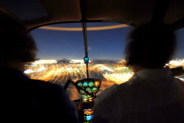
After clearing the runway area, I turned to the west. The roof on Chase Field was open and there were some lights on in there. Maybe they were doing some kind of maintenance. I didn’t fly close enough to see. I turned north to follow 7th Street past the tall buildings, then headed northwest. I wanted to hook up with Grand Avenue again before we left the brightness of the city. This photo by Jon Davison gives you an idea of what it might have looked like from the back seat.

The flight back was uneventful. As we reached Sun City and left the lights behind us, a sort of haze seemed to fill the cockpit. The first time I’d experienced this phenomena, it had scared me. Now I knew what caused it: my eyes adjusting to the lower light levels. I dimmed the cockpit’s instrument lights even more to prevent reflection on the inside of the bubble. My passengers were awed by the darkness we had to fly through.

Then we could clearly see the line of white that marked route 93: cars returning from Las Vegas on that Sunday night. They’d pass right through Wickenburg. We followed route 60 at an altitude of about 3,000 feet into town. Then I turned along the dark corridor of Sols Wash, keyed the mike button, and brought the airport lights to life. A while later, we were on the ground on one of the two helipads and Mike was driving up to give them a lift to the ranch and bring me home.

It was just after 10:00 PM.

This particular flight will be one of those that stays with me for a long time. Not because it was frightening or dangerous or beyond my skill level. It was none of those things. But it was a new experience that offered new and unique challenges. Any time I take on a reasonable challenge and succeed, I learn and become a better person.

And when it’s a flying challenge, I become a better pilot.

Moments to Remember

A drive through the desert on a starlit night.

Ever have one of those moments you wish you could remember for the rest of your life? I’m not talking about simple recall here. I’m talking about remembering with the detail you need to relive the experience in your mind.

I had one of those moments [again] on my way home from Phoenix last night. I’d driven down in the afternoon to pick up my husband, Mike, who had driven his Honda down that morning to pass it on it its new owners. I took my Honda S2000, which is a convertible, and because the weather was so perfect yesterday, I had the top down. After dealing with traffic on the afternoon drive through Phoenix, I finally connected with Mike on Chandler Avenue (or it is Boulevard?) in Ahwatukee. From there, we headed back into Phoenix, to one of our favorite restaurants: Tarbell’s on 32nd Street (I think) and Camelback. After a wonderful meal full of interesting flavors and textures, presented with perfect service, we climbed back into the Honda and headed northwest for home.

Tarbell’s is probably about 60 miles from Wickenburg. We took Camelback west to the 51, followed that north to the 101, and took that west to the 17. Then north to Carefree Highway and west to Grand Avenue and northwest to Wickenburg. I had my iPod plugged in, playing just below distortion volume on my Honda’s very disappointing stereo system. (The 2003 model year did not include speakers behind the headrests; what were they thinking?) I’m used to the less than satisfactory sound quality competing with road and wind noise, so I enjoyed the classic rock — mostly 70s and 80s — that I made Mike listen to. (The rule is, the driver chooses the music.)

The drive north on the 51 at night is always interesting. On most nights, you can see the landing lights of the jets on their way in from the north to Sky Harbor Airport just southeast of Phoenix’s downtown area. Last time I took this route home, I’d spotted at least eight aircraft, lined up into the distance. But last night, there were never more than four.

We stopped for gas at Carefree Highway — last gas for about 30 miles. My Honda gets between 25 and 30 miles per gallon, depending on how I drive. Because I don’t drive it very often, I tend to drive in a way that gets me lower mileage. (Hey, girls just wanna have fun, right?) But on a long highway drive, if I keep my speed down near the speed limit, I can go far more than 300 miles on a 13-gallon tank of gas.

Then came the part of the trip I’d like to store in my brain for periodic detailed recall: the drive west on Carefree Highway. It was about 7:30 PM, and even though it was a Friday night and Carefree Highway is a favored route for the Phoenix to Las Vegas crowd, there weren’t many people on the road. Once I passed the new Game and Fish Building (with its deplorable new traffic light) and rounded the bend at Lake Pleasant Road, I brought the car up to speed, set the cruise control, and drove while classic rock blared out into the night.

It was dark out there — it usually is at night — and a slim crescent moon hung in the sky, bright side down. I say “bright side” because the sky was so dark, you could clearly see the entire moon, even though most of it wasn’t illuminated. The crescent hung there in front of us, surrounded by stars, sinking ever lower into the sky. Above us, the sky was black as — well, black as night, to use an appropriate cliche. There were more stars than a city dweller could imagine; so many, in fact, that it was difficult to pick out the standard patterns of the Big Dipper, Orion’s Belt, and the Pleiades among them. And being that the sky was perfectly cloudless, those stars stretched in every direction.

What I should have done was pull over to a safe spot off the road, killed the headlights, and spent some time just looking up. Because frankly, when you’re driving 65+ miles per hour on a two-lane road in the middle of the desert at night, you really can’t steal too many glances at what’s directly above you. What’s in front of you is far more important to monitor.

Yes, it was cold — probably in the low 50s. Although the top was down, Mike had his window up and the heat was on. And yes, I hate the cold. But the cold was part of the entire experience: dark night, fun car, open roof, loud music, crescent moon, countless stars, cold wind.

The moon dipped behind a hill as we got onto Grand Avenue and drove the last ten miles to Wickenburg. In town, the carnival at the Community Center offered a bright contrast to the otherwise dark night. Town was surprisingly empty at 8 PM on Wickenburg’s big Friday night of the year.

I drove home, coming down from the kind of high you can only get from having real fun.

The Super Bowl is Coming!

Developments around the University of Phoenix Stadium in Glendale.

I’ve been doing flight training down at Glendale Airport for the past few weeks, working on my Instrument Rating at Silver State Helicopters. Two or three times a week, I drive or fly down there in the afternoon, spend a few hours sitting in a simulator trailer with a flight instructor, and fly or drive home.

The drive is long and boring. I found the best route though, thanks to my friends Ray and Robbie: Grand Avenue to Litchfield Road to Glendale Avenue to the airport. I can do it in just over an hour sometimes. It’s about 50 miles each way.

University of Phoenix StadiumGlendale Airport is just 3 miles or so from the University of Phoenix Stadium, where Super Bowl XLII will be held this Sunday. The other day, while waiting for the Glendale Tower controller to clear me across the runway, I overflew the stadium area. The grass was outside, looking rich and green. The top of the stadium was closed. A ferris wheel was under construction in the parking lot on the west side of the stadium and there were lots of party tents and other things going up.

The Super Bowl is apparently Glendale‘s chance at the “big time” and they’re doing everything they can to make it a big party.

At the airport, things are also changing. Glendale Aviation, which had been the FBO there for years, expanded its building and added a corporate hangar large enough to accommodate three small jets. (At least that’s how it looks to me.) It’s now called LuxAir — I guess you need a foo-foo name to attract football fans arriving by jet. Of course, since it’s the only real FBO there, there’s no competition at the airport. It’ll probably make enough money this weekend to cover the cost of the building addition and more. But it couldn’t have been timed any better; crews are probably putting on the finishing touches inside as I type this.

Last week, the ramp was completely full of small airplanes, like Cessnas and Pipers. Apparently, the guy who owns the hangars and shades evicted everyone while doing some upgrades, then raised the rents beyond what local pilots were willing to pay. Few planes went back. I guess their owners would rather roast their wings in the hot Arizona sun. But yesterday, the ramp was almost empty. They’d moved all the little planes under the shades or to the more remote parts of the ramp, leaving plenty of room for incoming jets. Even the DC3 that had been sitting there for months (if not years) had been towed to the far reaches of the airport ramp, tucked into a spot between the hangars and perimeter fence like a broken down truck in someone’s yard.

Inside the terminal, the lobby area’s furniture — a mixture of chairs and tables normally used by one of the flight schools for training and briefing — have been removed. In their place are leather chairs and tables, arranged in little chat groups. I can’t tell you how comfortable they are because I don’t know. They’ve roped the whole thing off with yellow caution tape so no one sits on them until the big money starts arriving. I’m willing to bet that next week, when I return, all that nice furniture is gone.

It’s almost as if Glendale Airport is putting on airs, like Scottsdale Airport.

Glendale Airport’s restaurant, which had been closed for months, reopened last week. It’s the same old place, but with new owners. I haven’t eaten there, so I can’t rate it. I’m sure they expect to do a good business over the weekend. Rumor has it that they’re going to do a buffet. Rumor also leads me to believe that they’re doing a buffet because they can’t deal with table service and they’re taking the easy way out.

Yesterday was my last afternoon at Glendale Airport until after the big event. I canceled Friday’s lesson so I could get an early start out to my weekend gig in Parker, AZ, chasing race vehicles around a desert racetrack with a film crew on board. Wickenburg is one of two area airports outside the 30-mile TFR (Temporary Flight Restriction) that’ll kick in around Glendale on Sunday afternoon, before the game, so even if I get back late on Sunday afternoon, I don’t have to worry about landing at my home base.

But I doubt whether Wickenburg will see the big jets. There’s plenty of room at Glendale and, thanks to the inability of Wickenburg’s Airport Consultants and Manager to plan for the future, only two jet parking spaces at Wickenburg Airport.

The above image of University of Phoenix Stadium is from Wikipedia and is licensed under Creative Commons Attribution ShareAlike 2.0 License (cc-by-sa-2.0). In short: you are free to share and make derivative works of the file under the conditions that you appropriately attribute it, and that you distribute it under this or a similar cc-by-sa license.

Flying in the Phoenix Area During the Super Bowl?

Not likely.

Here’s the TFR graphic for the Super Bowl. As you can see, Wickenburg (E25 in the northwest) is one of the few airports outside the forbidden circle that marks a 30-mile radius from the stadium in Glendale.

Super Bowl TFR

I just spoke to my FAA guy in Scottsdale and received confirmation that the only flights allowed within the circle after noon on game day will be police and security aircraft. Glendale Airport will be closed to all traffic. And they’ll definitely be writing up violations for the folks who bust that circle.

What does this mean? Well, it means that although I can fly all day out of Wickenburg if I stay to the north and west, I’m certainly not going to be ferrying folks around Phoenix. This is a good thing — I was really starting to get worried about dealing with security anyway.

It’ll be interesting to see how many F-16s get scrambled to chase down Cessnas that day.

I have a great gig lined up the day before in Parker, AZ. Maybe I’ll just spend an extra day there.

Down in the Valley

Observations from a day in the Phoenix area.

Yesterday, I spent much of the day in the Phoenix area and south of there. I’d like to note a few of my experiences.

Casa Grande

One of my errands yesterday was to take my 22-foot travel trailer, which I use primarily for “barnstorming gigs,” to the Casa Grande Airport. The COPPERSTATE Regional EAA Fly-In begins today and I’m one of two helicopter pilots who got a contract to offer helicopter rides.

RouteCasa Grande 109 miles south of Wickenburg, just off I-10 (see map). I was driving my husband Mike’s truck, a 3/4 ton Chevy SIlverado diesel pickup, towing the trailer. The truck, which normally has a lot of pep, drove as if I were hauling my old 13,000 pound horse trailer with living quarters rather than a 5,000-pound steel and cardboard — well, that’s what it seems like — RV. I was lucky to get it up to the speed limit on the highway. With high winds south of Phoenix, I wasn’t even able to get it up to the 75 mph limit. Later, I asked Mike about it. He says he thinks its wind resistance. The trailer has a flat front; the horse trailer was curved. The 218-mile round trip used up 3/4 tank of fuel.

ParkingIt wasn’t really clear until yesterday, when I arrived at the Casa Grand Airport, where I was supposed to set up. I found the spot described to me — a D-shaped bit of gravel (A on illustration) adjacent to the landing zone (LZ on illustration) and taxiway– and called the other pilot, Michael, to confirm with him. That was the spot.

I’d just hung up the phone when three guys rolled up on a golf cart. One of them was in charge of parking. He didn’t want me to park where Michael told me to.

I was kind of expecting this. Michael wanted me to park between the helicopter and a taxiway intersection. It would have been convenient for me and for passengers, but it was very close to helicopter parking and the taxiway. The parking guy was worried about the trailer blocking the view of pilots trying to taxi out. So he directed me to another spot nearby on gravel (B on illustration). It wasn’t as convenient a spot, but I had to agree that it was likely to be safer. And I didn’t think it was any less visible. So I called Michael again to reconfirm. He told me that was plan B and if I didn’t mind, it was fine with him.

Getting the trailer into the spot was a bit of a task. The parking guy wanted it lined up with the huge tent that had been erected there. I needed the door facing the landing zone. That means I had to drive the truck right toward the tent, get the trailer as close to the tent as possible, and still get the truck out. On my first try, I couldn’t get the trailer lined up with the tent, although the position wasn’t bad.

So I used my “helpless female routine.” Women who don’t know this routine are really missing out on something that can help them get assistance when they need it.

“I don’t drive this thing much,” I told the three men. “My husband usually does.” (That was a fib.) “If one of you are good at moving trailers around, be my guest.”

After a short debate, one of the men stepped forward. He got behind the wheel, did another circle in the gravelly area, and parked it almost where I’d had it, but with the truck pointing the other way. His companions directed him so he wouldn’t run over the taxiway light there and I kept him away from one of the tent stakes. I know it wasn’t quite as close to the tent as the parking guy wanted it, but it was lined up. They were all happy.

At this point, I’d identified myself as a helpless female who seldom dealt with trailers. So the three men came around the back of the truck to help me disconnect the trailer. This was very nice because the trailer has these sway bars attached to it that are heavy and difficult for me to disconnect. They disconnected them and I stowed them in the back of the truck. Then they guided me in the truck away from the trailer so I wouldn’t run over that darn taxiway light.

Then they got into the golf cart and rolled away.

But not before one of them asked me where I was coming in from.

“Wickenburg,” I said.

“Wickenburg!” he replied. “I didn’t think anyone lived there.”

“They don’t,” I told him.

I spent the next half hour organizing the trailer a bit and putting up a pair of rides signs so the folks setting up would know what the trailer was for. I also lugged the 4 6-1/2 gallon water containers I’d put in the back of the truck out of the truck. (In the old days, when I was younger and thinner and better looking, the helpless female routine would have had one of the guys volunteering to do this for me. Such are the pitfalls of middle age.) Then I locked up the trailer and started the long drive home.

Wild Horse Pass Resort & Spa

On the way home, I had a stop to make at the Sheraton Wild Horse Pass Resort & Spa. This is a resort that’s part of a casino complex on the north end of the Gila River Indian Reservation.

The place is pretty new. I know because I learned to fly in Chandler, which isn’t far from there, and once in a while, my instructor and I would take the helicopter out to the Gila River to find the wild horses. There are an estimated 1,500 of them out there, although we never saw more than 100 or so at a time. The resort didn’t exist back then.

I was impressed by the place as I drove up to it. The entrance road winds through a desert golf course that has a flowing stream running through it. But this isn’t a 100-yard bit of water pumped through the desert. The stream goes on for over a mile, with small rapids, ponds, ducks, and riparian vegetation. It’s the kind of stream I’d want to hang out beside in the shade, on a summer day. (Not an Arizona summer day, of course. You’d bake.) The stream was full of water and at least 8 feet wide in most spots. Although it had to be man made — there are no natural streams like that in the area — even the Gila River is almost dry — it looked completely natural. Very nice.

I pulled up in front of the place and was flagged down by a valet parking guy. I asked for directions, then parked the truck myself down in a parking lot. I gathered the things I needed for my meeting and walked back up to the main building.

Inside, I was impressed again. The main building’s entrance is on the top of a hill. When you walk in, you’re faced with a huge wall of windows that look out onto the golf course and mountains. It was a two-story walk down stairs at the side of a rock face to get to the lower level lounge. The view was magnificent.

Now I’ve seen this kind of lobby in several hotels in the Phoenix area. The Hyatt at Gainey Ranch has one and so does the Westin Kierland. But neither are as dramatic and beautiful as this. I was really impressed.

And those of you who read my blog frequently know how seldom I’m really impressed.

I think the place would make a great getaway for Mike and me. Maybe early next season we’ll try a weekend there.

iPhone Spotting

I had my first iPhone “in the wild” spotting yesterday. (Keep in mind that most of Wickenburg’s population is somewhat technologically challenged, so I don’t get a chance to see much in the way of gadgets here in town.) It was in the parking lot for A.J.’s Fine Food (my favorite supermarket) on 67th Avenue at the Loop 101.

The guy was holding the phone in one hand and a pair of white earbuds hung from his ears. (For the record, I purposely bought black earphones for my iPod just so I wouldn’t look like an Apple fangirl.) He was talking loudly to someone about how he wasn’t interested in getting into a relationship. A young girl maybe 4 or 5 years old and holding a baby doll, was walking along with him, trying to keep up, trying to talk to him. He was completely ignoring her. I think that if someone had come up behind them and taken the kid away, he probably wouldn’t have noticed — or cared.

The guy struck me as a complete jerk.

I have more to say about iPhones, but I’ll save that for another post.