What I’ve been up to — and why I’ve been too busy to blog.
I haven’t been blogging regularly for the past week or so. That’s because I’ve been on the move.
Monday, July 28
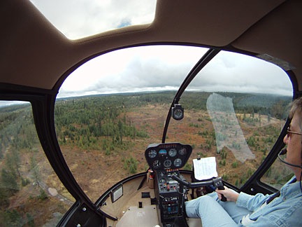
 I spent the morning cleaning out my hangar at Quincy for departure the next day. Then I flew up to Chelan and met my friend Jim. He flew us in his helicopter to Spokane, ID for lunch and then on to Coeur D’Alene, ID where he’s based. He demonstrated a confined space landing by setting down in the parking area of his business property in downtown Coeur D’Alene to offload a bunch of stuff. Then we went to the local airport, fueled up, and picked up his wife for the return flight to Chelan. I got some great photos of combines in action on the dry wheat fields. We landed at Chelan with just enough time to chat with another helicopter pilot before it was time for me to fly back to Quincy.
Tuesday, July 29
I spent much of Tuesday morning preparing to leave Quincy. I had to disassemble my helicopter tow bar and stow its pieces in the back of my truck, then clear out everything else still in the hangar I’d been renting. I also had to drop off my last month’s rent. I bought some cherries and other fresh fruit, too.
I had just enough time for a quick shower before visitors started coming. Louis, who would fly with me later in the day to Seattle, arrived first. Then Teresa, Jim’s wife, arrived with Jim’s pickup. He bought the remaining fuel in my transfer tank — about 50 gallons of 100LL — for $4/gallon. A great deal for both of us, since I wanted the fuel out to lighten up my truck. We pumped the fuel from my transfer tank to Jim’s and Teresa departed.
Then Louis dropped me off at Quincy Airport and drove my truck to Wenatchee. I took my helicopter to Wenatchee to meet him and we flew from there to Seattle’s Boeing Field, on a marginal weather flight I reported in some detail here. After a chat with my mechanic there, Louis and his mom dropped me off at SeaTac. I had a pretty good halibut dinner at Anthony’s before I caught a flight back to Wenatchee. I was back in my camper by 9:30 PM, exhausted.
Wednesday, July 30
Wednesday was the big day. I packed up the camper, stowed Alex the Bird on board the truck in his travel box, hooked up the camper to the truck, and pulled out. I’d been in my campsite for just a few days short of two months.
My destination was Walla Walla, WA, about 150-200 miles away. I chose a route that kept me on back roads. I don’t think I ever saw so much wheat in my life. My chosen route took me past Palouse Falls, so I stopped in and got some photos. It was an interesting place and well worth the stop.
From there, I continued on to Walla Walla, with a stop at a drugstore soda fountain in Dayton for an ice cream sundae. I checked into the Four Seasons RV Park around 5 PM, set up the camper for a two-night stay, and went out to grab some dinner. I wound up at a restaurant called Luscious, where I had an excellent polenta dish and a glass of wine.
This is also the first day I gave my new SPOT Messenger a workout. You can track my progress for this entire trip on my Share page, http://www.tinyurl.com/FindMaria. You’ll have to page back using controls under the Waypoints list to see the track for that day.
Thursday, July 31
There was something about dinner that didn’t agree with me, no matter how tasty it was, because I was up at 3 AM, leaning over the camper’s toilet and choking it all back up. I hate to puke but what they say is true: you do feel better when you’re done. But I wasn’t operating at 100% the next day, which I’d set aside to explore opportunities in Walla Walla.
It’s no secret that I pretty much hate where I live right now. Wickenburg is a dead town, full of ultra conservative retirees who live there only half the year and don’t spend much of their money in town when they’re around. They don’t have an emotional investment in the town and don’t seem to care what happens to it. As a result, new businesses — other than those that cater to the budget-conscious — don’t last more than a year or so. There are few decent restaurants and very few shopping opportunities. If it weren’t for the newly built and then remodeled Safeway Supermarket and a handful of longtime other businesses, I don’t know how I could live there at all. To make matters worse, the Mayor and Council seem more interested in growing the town’s population base for the financial benefit of their families and cronies than building an economic base that includes good-paying jobs that’ll attract young, vibrant people. The Chamber of Commerce pushed for an in-town “bypass” that’s destroying downtown parks and other facilities and adding a “roundabout” that’s sure to cause daily accidents. I love my home and its immediate surroundings and it’s painful to see how they’re destroying whatever was good about the town. There’s nothing else here for us anymore. All of our friends in our age group have already left town. We’re the only ones left.
So I’m exploring possibilities and Walla Walla was high on my list. I spent some time checking out the very pleasant historic downtown area, where it was nice to not be the youngest person on the street. Then I went over to the airport to meet with the airport manager about moving my flying business there. She was extremely helpful and enthusiastic and said a lot of things that made me believe I’d be welcome there. (What a refreshing change that was.) There would certainly be a lot more opportunities in that town than where I’m based now. I also checked out a few wineries — there are dozens in the area! — although I couldn’t do any tasting with my stomach so iffy all day.
By 4 PM, I was exhausted. I went back to the camper to relax and wound up staying in for the rest of the night.
Friday, August 1
On Friday, I needed to get an early start. I was expected in Salt Lake City at 6 PM. I’d be spending the night at the home of my friend and editor, Megg, and her family. Utah (MDST) is 1 hour ahead of Washington (PDST) so I’d already lost an hour. Trouble was, I needed to visit the post office to see if a General Delivery letter (containing a large check) had arrived. So I got as much prepared as possible before 9 AM and drove into town again. The check was there. I stopped at an excellent bakery that had been highly recommended by a Twitter friend and bought a fruit tart to bring to my friend’s place. Then I gassed up the truck.
Back at the camper, I was all ready to hook up the trailer when I realized that I was missing a leverage bar I needed for the hitch. I wasted an hour searching for it, then gave up and went to Home Depot to buy a replacement. That little fiasco cost me another hour. I didn’t get on the road until 10:30 AM.
That meant I had to take highways. I drove down to Pendleton and hopped on I-84 eastbound. And thus started a very long, very grueling day of driving. The trouble is, my 1994 Ford F150 8-cylinder pickup truck, when towing, is no match for hills and mountains. On flat areas (or downhill, of course), I could get it up to 65 MPH. But as soon as I started to climb, my speed deteriorated. Down to 35 MPH. Trucks were passing me.
And the roads through eastern Oregon and southern Idaho are very hilly.
I plowed on, stopping only for fuel and some fast food that I ate while driving. The hours slipped away. I was just entering the Salt Lake basin area when the sun set. It was about 8 PM. After making two wrong turns, I pulled up in front of Megg’s house just after 9 PM. I’d been on the road for more than 10 hours and was exhausted.
Megg fed me and helped me bring Alex the Bird’s cage into her dining room. By 11 PM, I was asleep in her guest room.
Saturday, August 2
We got up early and hit the farmer’s market in downtown Salt Lake City. This was, by far, the best farmer’s market I’d ever been to. Plenty of fresh produce, baked goods, and other items you’d expect to find at such a place, as well as other non-food items that generally dominate most other farmer’s markets in this country these days. Megg had her 5-year-old son, Cooper, along and we joined Megg’s friend and her 5-year-old son for coffee and scones at a shady table in the park. I felt as if I could have spent the whole day there — it was so pleasant.
But we headed out to the Snowbird ski resort area, where we took a hike in Albion Basin. The area had been recommended by photographer and Twitter friend Ann Torrence, who linked to a photo of the place that made it irresistible. The three of us hiked about 2 miles round trip to Cecret Lake (also spelled Secret Lake). I took a lot of photos; this is one of them. The place was amazingly beautiful. Again, I think I could have spent the whole day there. But we didn’t have a whole day. In fact, I was hoping to be back on the road by 1 PM.
The departure time slipped as we went to the Snowbird Ski Resort and took the tram to the top of Hidden Peak. I’m so out of shape I was huffing and puffing at 11,000 feet. We headed back to Salt Lake City where I scrambled to get everything together. It was 3:30 when I said goodbye and hit the road again with Alex.
My goal had been to reach Page, AZ before nightfall. That simply was not going to happen — especially with the way my truck was climbing hills. I wound up in Beaver, UT, where I had dinner at a truck stop before pulling into an RV park for the night. I didn’t unhook the trailer or pop out any of the beds. Instead, I just plugged in the power cord, opened the sofa, and snuggled up in a comforter with a pillow.
Sunday, August 3
I pulled out of the RV park at 6 AM sharp and continued south on I-15 to SR 20 to US 89. It wasn’t until I got to Mt. Carmel Junction that I stopped for breakfast and fuel. I was back in familiar territory — the turn at this junction leads to Zion National Park. After breakfast, I continued down through Kanab, stopping to take a photo of a reflecting pool alongside the road along the way. Then I continued east and was very pleased to see the silhouette of Navajo Mountain off in the distance.
I arrived at the Glen Canyon Dam visitor’s center at 10:30 AM. Mike was already there with his truck and Jack the Dog. We had another breakfast in Page, then went to the airport to chat with the folks I’ll be flying for there, and finally to the campground, where we were told we were “lucky” to get a spot. (There’s more to this story, but I don’t feel like going into it now.) We spent the rest of the day picking up a few things for the camper and then just taking it easy. We had dinner in town, then came back to the trailer and watched a movie on my laptop before falling asleep.
Monday, August 4
We did a lot of chores that morning. We had to button up the camper to move it to another site (which we were “lucky” to get) that was suitable for monthly use. It turns out, the only thing that made it suitable was an electric meter, so if I sucked too much electricity, they could charge me for it. The new site is right near the road, which I’m not happy at all about. But I’m hoping it’ll be close enough to the office to connect to the WiFi network there.
We left Mike’s truck with the trailer and climbed back into my truck with the stuff I wouldn’t need anymore — including Alex’s cage. Then the four of us headed home. We’d gotten about 15 miles south of Page when Mike realized he’d forgotten his cell phone. We went back to fetch it, then bought milk shakes that were way too big (and way too expensive) for the ride. At 2 PM, we were in Flagstaff, where we stopped for a Thai food lunch. We were still full from the damn milk shakes, so we wound up taking most of the food home with us.
We were in Wickenburg by 5:30 PM. I fetched one of my cars from my hangar and came home.
Busy enough for you?
So that’s a whole week and then some, all accounted for here. You can see why I didn’t blog regularly. Hopefully, this long post will make up for it — if you could last through it all.
We hit the road again on Friday morning, when we fly to Seattle to fetch the helicopter and bring it down to Page. I hope to be able to share more stories and photos with readers then.
Until then, remember that you can track my progress for most of my trips these days on my SPOT Share page, http://www.tinyurl.com/FindMaria. Use controls under the waypoints list to scroll back through previous days.
And be sure to check out my photo gallery for larger images of what I’ve shared here: http://www.FlyingMPhotos.com/.


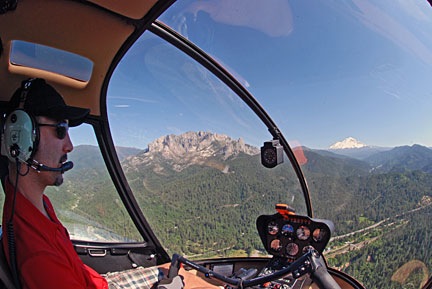
 Scud running is dangerous and I don’t do it without full understanding of that danger. Not once did I ever lose sight of the ground or immediate surroundings. When I realized I could not go forward the way I was going, I went back. As you can clearly see by shape of the white line U-turns I made, I was required to turn in two very tight places. These are turns that an airplane could not accomplish, especially since they were made in narrow canyons with no view over the canyon walls. The photo here shows how low the clouds were on that third attempt — the successful one. At several points, I was 200-300 feet below the clouds.
 I left Wenatchee Heights with my 5th wheel RV hooked up behind my husband’s Chevy pickup. The first day’s drive was relatively short: from Wenatchee Heights to Walla Walla, a distance of only 190 miles. Only a small portion of the drive was on a freeway (I-90); the rest was on back roads through farmland.
 In Walla Walla, I stayed at the
  On Friday night, I got the trailer hooked up again and mostly ready to go. I needed to be on the road early for the next leg of my trip: from Walla Walla, WA to Draper, UT (south of Salt Lake City), a distance of 606 miles. I was on the road not long after dawn. The route took me south almost to Pendleton, OR, then onto I-84 through Oregon and Idaho and down into Utah, where I picked up I-15. The landscape started with farmland, then mountains, then more flat farmland, then more mountains, and then finally into the Salt Lake basin. I’d driven the route before with my underpowered Ford F150 pickup towing my old 22-foot Starcraft. It wasn’t fun then; Saturday’s drive was much more tolerable. I stopped three times for fuel and twice for food. It was very unlike me to make so many stops; I usually try to get food and fuel on the same stop, but the situation made that tough. I rolled into Draper, UT’s Camping World parking lot at 6:15 PM local time, just 15 minutes after the store closed. I’d called the week before and knew I could park out back, so I did. I even got to hook up 50 amp power.
 On Sunday, @AnnTorrence picked me up for a drive to Ft. Bridger, WY. There was a
 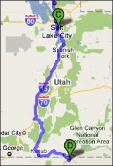 Monday — Labor Day — was my last drive day. I drove from Draper, UT to Page, AZ, a distance of 370 miles. I got a very early start, pulling out of the parking lot at 6:30 AM local time. By the time I stopped for fuel two hours later, I’d already gone more than 100 miles. (I parked with the big rig trucks and discovered that my rig was about as long as theirs.) This part of the drive was mostly on I-15, but started east on route 20 to Highway 89, which took us all the way to Page. The roads were mountainous and there was a lot of climbing and descending. There were also a lot more vehicles on the road, making driving a bit more of a chore.
 The only food stop I made along the way was at the Thunderbird Restaurant at Mount Carmel Junction. The place is a bit of a tourist trap, but it does have good “ho-made” pies (whatever that means). Odd thing happened when I tried to leave. They couldn’t give me a bill because the computer was down. Apparently no one knows how to do basic math. All I had was a piece of pie with ice cream and an iced tea. They apparently expected me to wait until the computers came back online. With Alex the Bird in the front seat of the car, that was not an option. Finally, my waitress disappeared into the kitchen where she may have used her “lifeline” to get help with this difficult math problem. The verdict was $7.79. I was afraid to count my change.
 My husband, who’d flown up in his plane and spent a few hours swimming in the lake, met me at the lodge restaurant for lunch. Afterwards, we put fuel in the truck and parked it (temporarily) at Page Municipal Airport. I gathered my belongings — forgetting only two things, one of which was vital — and we loaded into Mike’s plane. Then we started the long (90 minutes), hot (90°F+), and bumpy (I almost got sick) flight to Wickenburg. The only sights of interest along the way — keeping in mind that I make that flight about 1000 feet lower at least a dozen times a year — were a handful of forest fires east of our Howard Mesa place and a heavy rain shower coming out of a remarkably small cloud near Granite Mountain.

 I spent the morning cleaning out my hangar at Quincy for departure the next day. Then I flew up to Chelan and met my friend Jim. He flew us in his helicopter to Spokane, ID for lunch and then on to Coeur D’Alene, ID where he’s based. He demonstrated a confined space landing by setting down in the parking area of his business property in downtown Coeur D’Alene to offload a bunch of stuff. Then we went to the local airport, fueled up, and picked up his wife for the return flight to Chelan. I got some great photos of
  My destination was Walla Walla, WA, about 150-200 miles away. I chose a route that kept me on back roads. I don’t think I ever saw so much wheat in my life. My chosen route took me past
  But we headed out to the Snowbird ski resort area, where we took a hike in Albion Basin. The area had been recommended by photographer and
  I pulled out of the RV park at 6 AM sharp and continued south on I-15 to SR 20 to