Snowbirding 2016: Valley of Fire

A short overnight visit to a geologically interesting place.

Posts in the Snowbirding 2016 Series:
Introduction
The Colorado River Backwaters
Quartzsite
Wickenburg
Phoenix
Home
Back to the Backwaters
Return to Wickenburg
Valley of Fire
Death Valley
– Back to Work

When I left Wickenburg that Sunday morning, I was technically on my way to my late winter job in the Sacramento area of California. Indeed, I had to be in Sacramento to catch a 6:40 AM flight home on Friday to fetch my helicopter. But I’d planned the drive with enough time to make two stops along the way. The first was Valley of Fire State Park near Overton, NV.

Valley of Fire gets its name from the vibrant red rocks that jut out of the desert floor in this area of Nevada. It’s full of scenic overlooks, easy to difficult hiking trails, and plenty of interesting sandstone formations. In the right light, it’s quite photogenic. It’s also easy to visit. Only 50 miles from Las Vegas, it gets quite a few visitors on weekends — as I soon found out.

Camping with the Mobile Mansion

When I planned the trip, I didn’t realize it was a holiday weekend — since when is President’s Day right after Valentine’s Day? — and had half expected to be able to slide into a campsite inside the park that Sunday afternoon when weekenders left. I’d also been assured by a friend who’d been there weeks before that if all the campsites were taken, I could park my rig in “overflow parking.”

Wrong on both counts.

When I arrived in early afternoon after a long but pleasant drive up Route 93 from Wickenburg, the weekenders weren’t quite through with their weekends and the first come, first served campgrounds were marked “Full.” I managed to park my rig along the curb in a completely full Visitor Center parking lot and went in to talk to a ranger. She confirmed what I’d already learned on the Self-Pay Station signs: camping in designated sites only. But she was extremely helpful, offering suggestions for camping on Bureau of Land Management (BLM) land west of the park or Bureau of Reclamation land east of the park.

Since the Reclamation land was closer, I soon found myself backtracking out the park entrance I’d come in and then turning north along the main road there. In a few miles, I found the gravel road I thought she’d referred to and made a right onto it. I could see a few other campers out there, quite far from the road. Since I wasn’t interested in exploring with the mobile mansion behind me — it’s seriously difficult to turn that sucker around in a narrow space — I opted for the first “pull through” spot I could find: a narrow road that climbed up a hill with a relatively level spot on top. I approached it from the east after turning around in a wide area and parked with the Mobile Mansion’s big back window facing out toward the lake. When I got it level enough that I didn’t have to worry about it rolling back down the hill, I dropped the landing gear and disconnected it from my truck. Then I put out the slides, gave Penny some food and water, locked it back up with Penny inside, and headed back into the park.

Another free campsite, courtesy of our government.

I later discovered that the location the ranger had referred to was about a half mile farther down the road where there were literally dozens of RVs, some of which were even bigger than mine, parked. I was glad that I wasn’t among them, though — I know half of them would be running generators past dark; likely watching satellite TV instead of the stars. There was no one within a quarter mile of my site and the closest campers were in tents. I had no intention of ruining their quiet evening with my generator so it was all good.

Afternoon Photo Shoot

Closer Look at Valley of Fire
Want to learn more about what’s photogenic in the park? Start with this €4 ebook.

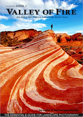
It was nearly 4 PM and the sun was low in the west when I got back into the park. I took the road north from the Visitor Center. I was very interested in hiking out to a formation called the Fire Wave, which was best viewed in the afternoon. My photographer friend Rebecca, who had been to the park recently, had recommended an ebook about the park: A Closer Look at Valley of Fire by Isabel & Steffen Synnatschke. That’s where I learned about the Fire Wave, which is pictured on the cover, and it was exactly the kind of scenery I like to shoot.

Of course, what had been described in the book as something off the beaten path had since gotten its own marked path. The parking lot there was completely full and there were people all over the place. Even if I could have parked, I doubted I could get the kind of scenery-only photos I wanted. On top of that was the authors’ note that the scene was best shot just after sunset and numerous signs that warned that anyone out on the trails after sunset was trespassing. So it seemed to me that a walk down to the Fire Wave that afternoon would be a frustrating waste of time.

I continued out to the end of the road, finding every single parking area completely full with day trippers who were out of their cars and climbing all over the rocks. While it’s nice to see families enjoying the outdoors together, I really wish I’d come on a weekday when it would likely be a lot less crowded. I turned around at the end of the road and headed back.

Red Rocks
I spent an hour shooting various rock outcroppings with various lenses from various positions. It was nice working alone, unrushed with plenty of time to experiment.

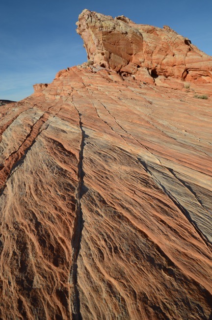
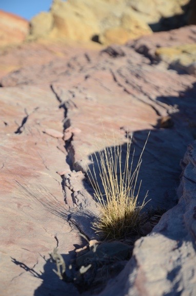
I wound up parking at an almost empty parking lot beyond the Fire Wave’s lot on the way back. From there, I struck out into the desert to the northeast with the thought of maybe coming up on the Fire Wave or an area like it from the other side. That didn’t pan out, but I did find some interesting rock outcroppings to photograph. I walked about a mile with Gaia GPS turned on in my phone to record my track. In addition to my phone, which I used to take a few photos for my Gaia track, I had my Nikon with me, along with three lenses. I got a chance to use my 10-24mm lens, which I rarely use, to take some really wide angle shots. As the sun got lower and lower, the shadows grew, giving the rocks a three-dimensionality they wouldn’t have when the sun was higher in the sky. The tricky part was keeping my shadow out of some of the shots. And I tried to tread carefully among the sometimes delicate rock formations to keep from crushing thin rock ridges beneath my feet.

Cactus with Red Rocks
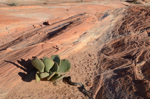
Another wide angle shot, this one featuring a type of prickly pear cactus that would likely be in full bloom with large pink flowers within two months.

Selfie
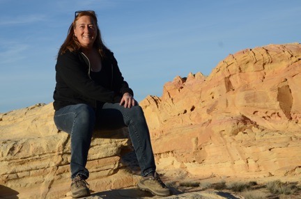
I seldom share selfies — I usually don’t like the way they turn out — but was very pleased with this one.

On the way back to the truck, I stopped for a selfie with the park behind me. The battery in my camera’s remote was apparently dead — no real surprise there — so I did it the old fashioned way, with the camera’s self-timer. I was very pleased to get a good shot on the first try.

Sunset
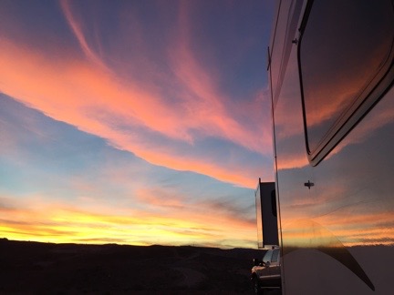
Another beautiful desert sunset, reflected on the side of the Mobile Mansion.

I explored a bit more of the park before the sun set, trying to find a good place for a morning shoot the next day. Then I headed back to the Mobile Mansion. Penny, as usual, was glad to see me. We went for a walk and I watched the sun set. Later, while I was having dinner, I watched the flickering dots of nearby campfires through my big back window, marveling at how bright the moonlight was.

Morning Photo Shoot

I was up, as usual, before sunrise. My closest neighbors had started a campfire, likely to keep warm. I could see it flickering off in the distance. It reminded me of my days at the backwaters in January and early February.

I made a cup of coffee to go and grabbed a snack bar for breakfast. Then, as the sky brightened to the east, Penny and I were in the truck, headed into the park.

Stone Walls
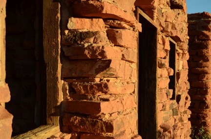
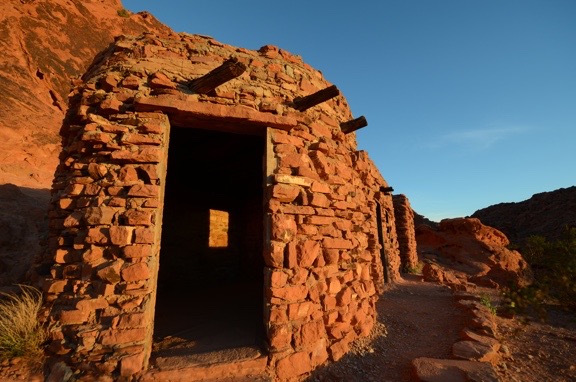
I love the textures of the wood window frames and stone walls at the Cabins.

Although I’d read through the Valley of Fire book looking for ideas of where to go for that morning shoot, I decided, in the end, to keep it simple: I’d go to the Cabins, a trio of stone cabins built by the Civilian Conservation Corps (CCC) to house workers years ago. The book panned the Cabins as a photographic destination, claiming it wasn’t interesting unless they were lit from inside. I disagree. I was there before sunrise — trespassing? — and began shooting almost immediately. The first light on the cabins was extraordinary and I got more than a few interesting shots. I was the only one around and, again, it was a real pleasure to shoot on my own without having to deal with other photographers or tourists. (Honestly, I don’t understand why people go on photo excursions where they have to jockey with other photographers for a good spot to take a shot.) My only challenge was keeping an eye on Penny — and keeping her out of my shots.

Cabins in First Light
The Cabins at Valley of Fire, shot with a 10mm lens at first light. No, I didn’t retouch this (or any other image) here. It really was that red.

Grass and Rock
Yet another wide-angle close up. The light had already become too harsh by the time I shot this.

Afterwards, I drove farther into the park, retracing my route from the afternoon before. It was around 7 AM, the Visitor Center was still closed, and there wasn’t another soul in sight. I parked alongside the road in one of the numbered dips where the road crosses a wash, got out alone, and began hiking down a slot canyon. The sun hadn’t climbed high enough to illuminate the canyon walls and there were deep shadows. According to the book, the canyon would eventually end up by the Fire Wave. I didn’t get that far, however — the canyon was full of water about a quarter mile in.

I turned around and went back to the truck, then crossed the road and headed off to the west. By that time, however, the light had become bright and harsh — not good for photographing desert landscapes. It was time to go.

Hooking Up and Heading Out

After taking a drive through the west side of the park, Penny and I headed back to the Mobile Mansion. It was around 9 AM. People were just starting to come into the park.

After a quick drive farther down the road where I’d parked — mostly to scout it out for better sites for a future stay — I returned to my rig and began the relatively quick task of hooking it up to the truck and getting ready to move on. Although it’s big, I’ve learned over the years that if I don’t take a lot of stuff out of storage while I’m parked, it’s pretty quick to close up for travel.

By 10 AM, we were rolling back down the gravel hill and onto the pavement. We’d have to drive through the park again — it was the shortest route to I-15. I had to show my pay stub at the ranger station on the west side to exit. Then we were on our way to our next destination: Death Valley.

Some Thoughts on Travel

“We travel not to escape life, but for life not to escape us.” – Anonymous

Ludwigsburg
Perhaps my wanderlust was fed by this 1976 trip to Germany with my grandparents. Or perhaps it’s in my DNA, planted by my maternal grandfather, who used to follow us on vacation when I was a kid.

I need to start off by saying that I love to travel. I love getting into a car or plane or train with luggage and going someplace and staying for a while. I love learning about new places, meeting new people, and seeing new things.

Travel for Work

In the past, I was fortunate to have had a series of jobs that sent me all around the country. My job as an internal auditor for ADP (based in New Jersey) sent me to Chicago, Kansas, Los Angeles, Orlando, New Orleans, Denver, and Washington DC, as well as a few places closer to home. Trips ranged from one to three weeks in length. The job was 40-50% travel and I was told I’d get tired of it. But I never did.

When I started out as a freelancer, I worked as a hands-on computer trainer for Data Tech Institute. They sent me on numerous trips all over the eastern half of the country, from Milwaukee to Cape Cod to Atlanta. The trips were three days each: a travel day followed by two work days with travel at the end of the second day. I remember one particularly busy month when I visited eight different cities with 20 airplane legs and a round trip train ride. While I was exhausted at the end of that month, I was also ready for more.

Later, my writing work took me to New York, Boston, San Francisco, Toronto, Vancouver, Santa Barbara, and Boulder to speak at conferences, meet with editors, and record video courses. I looked forward to every single trip.

Even my flying work got me traveling. Short trips to tourist destinations like the Grand Canyon, Sedona, Monument Valley, and Las Vegas. Overnight trips for survey and photo flights in northern Arizona, New Mexico, California, and Nevada. Training flights to the Los Angeles area. Long-term trips to Washington (where I later moved) for cherry drying and to California’s Central Valley for frost control. I loved those trips most — probably because someone was paying me to fly my helicopter there.

I simply loved to travel.

Don’t get me wrong — It isn’t because I didn’t like it at home — I did. (Well, I did until my marriage started falling apart.) I just liked to get out and get a new perspective of the world. And to me, that’s what traveling is all about.

The Stay-At-Home Rut

My future wasband and I traveled quite a bit during the first 20 or so years of our relationship. We had some amazing trips: Seattle to San Francisco by car; Shenandoah Parkway, Skyline Drive, the Blue Ridge Parkway, and the Outer Banks by motorcycle; and a handful of islands in the Caribbean by cruise ship are among the top 10. He even accompanied me on quite a few of my business trips — several times to California and once to Hawaii on my frequent flyer miles — and I went with him on a few of his.

Havasu Falls
I went to Havasu Falls for the first time in 2004 on an Arizona Highways photo excursion. Alone, of course.

But that ended in the mid 2000s when he started a series of dead-end jobs with limited vacation time. Suddenly, long trips were difficult to arrange and weekends were the only time he could get away. (Unless, of course, he needed to visit his mother; he could always make time for her.) I tried to get him to commit to one three-day weekend trip every month. Doesn’t sound like much, does it? But it apparently was.

I fell into in a stay-at-home rut. I wanted to travel — and I did actually make a few trips on my own — but unless it had some connection to my work, it wasn’t easy to do without having to deal with the resultant guilt trip my wasband put me on. You see, it wasn’t fair to leave him behind. Why should I have fun when he couldn’t? So I stayed at home, waiting, eventually looking forward to spring when I could go back to Washington, get a change of scenery, and spend time with friends. By that time, didn’t want to be at home.

Things are different now, of course. I don’t have a ball and chain holding me back. All I have is a 10-12 week period every summer when I’m stuck in the Wenatchee area for cherry drying work and another 8 weeks in early spring when I need to be within a few hours commercial flight time of Sacramento for frost work. I’m pretty much free to travel the rest of the year. Best of all, I don’t have to wait for a weekend to do it.

I got a chance to really stretch my legs in the autumn of 2012 and spring of 2013 with multiple trips from Arizona to California, Las Vegas, Washington, and Florida. I can’t tell you how good it felt to finally be able to go wherever I wanted whenever I wanted.

The Benefit of Traveling Alone

Beatty NV
My self-labeled “midlife crisis road trip” in the summer of 2005 lasted 19 days and covered 10 states. I saw a lot of off-the-beaten-path places, like this ghost town in Nevada.

Although I do prefer traveling with a good travel companion, I’ve only managed to find one — and she lives in Colorado with her own set of responsibilities. I thought I’d found another this past summer, but we apparently had different ideas of what “sharing the cost” meant. If I’m going to pay for more than half a trip, I’ll take it by myself so I don’t have to compromise with a “frugal” — his word, not mine — travel companion.

Compromise is only part of the problem when traveling with a companion. The other is spontaneity — the ability to make last minute plans and see them through. When there are two or more people traveling, planning a spur-of-the-moment trip is nearly impossible. Even making changes to travel plans once you’re on a trip is difficult. But when you’re running the show and you don’t have to worry about making someone else happy, you can do whatever you like, whenever you like.

And that’s where I am today. Loving it.

Recent Trips, Upcoming Plans

Since cherry season ended in late July, I’ve gone on several trips:

All that in three and a half months! It’s amazing I get anything done around here.

And that doesn’t include day trips to Seattle (for shopping), Woodinville (for wine-tasting), or local hiking trails and mushroom-gathering locations.

Right now, I’m thinking about other trips. I’ve already got an overnight trip to Spokane (yeah, big deal) with a friend planned. If I don’t spend the winter in Arizona, I’ll likely go on my annual cross-country skiing trip to Winthrop. One way or another, I’m sure Arizona will be a January destination — I’m thinking of driving down with my boat and stopping at various lakes along the way. Looks like I’ll spend part of the late winter in the Sacramento area again for frost; if that doesn’t pan out, I’ve got a job offer in Ohio that I’ll try to grab. (Yes, I do work for a living.) I’ll be back in Idaho with my boat to visit friends with a new home on the Spokane River and would love another trip to Alaska in May.

What about big trips, like the one I’d hoped to take with my wasband in late 2012 to Australia? Well, those are on the back burner right now while I finish my home and get my helicopter ready for its overhaul next winter. Once that’s all done and the dust has settled, I’ll be thinking about going way south for the winter of 2017/2018.

A travel companion would be nice, although not required. I’m looking for just the right person to join me.

A Weekend in Wenatchee, a Helicopter Flight Home

Cramming a lot into three days.

Last weekend, I took Alaska Air/Horizon from Phoenix to Wenatchee, WA. I left on a Friday morning with the goal of being back in Wickenburg with my helicopter on Sunday night.

Friday: The Travel Day

Pilot Don
Don at the controls, over Peoria, AZ.

My day started early at Wickenburg Airport. My friend, Don, came to pick me up in his helicopter at about 8:30 AM. After topping off his tanks with fuel — which was cheaper at Wickenburg than his winter base in Deer Valley — we headed southeast.

Don is one of my good friends. Like me, he lives in Washington in the summer and Arizona in the winter. But unlike me, his main home is in Washington; mine is in Arizona. The past two winter seasons, we shared hangar space — at least part time — at Deer Valley Airport. That’s where we met. Don owns an R44 like mine but blue. He’s retired and likes any excuse to fly. On Friday morning, I was his excuse. He came up to Wickenburg, picked me up, and flew me down to Sky Harbor.

What most folks don’t know is that Sky Harbor Airport in Phoenix has a public helipad on the top of the Terminal 3 parking structure. (Don’t believe me? Next time you’re at the airport, take your car up there to the roof and see for yourself.) The helipad doesn’t get much use. In fact, I’m willing to bet that Don is one of the top 10 users with me in the top 20 during the winter months. I blogged about the helipad here and here and even put a video online here.

Don Flies Away
Don’s departure to the north.

Don dropped me off with my limited luggage, waited until I was clear of the helipad, and flew away to the north. I had just two small bags: an overnight bag that contained primarily camera equipment and my Bose headset bag. My A20 headset had been repaired under warranty and shipped back to my Wickenburg home; I wanted to use it on my upcoming long distance flight.

I took the elevator down to the baggage claim level, went out to the curb, and waited for the airport shuttle bus. I was at Terminal 3 and needed to be at Terminal 2. If it wasn’t so damn hot out already — at 9 AM! — I would have walked it. Instead, I waited for the bus, consulting my watch every 30 seconds.

Fortunately, the security lines at Terminal 2 were short and they didn’t ask me to go through the naked x-ray machine — which I won’t go through. So I was walking to my gate with time to spare before my 10:20 AM flight. Enough time to get a shoeshine and spend most of my time in the chair helping the shoeshine guy attract his next customer.

Grand Canyon from Airliner
This is what the Grand Canyon looks like from an airliner. And yes, I’ll admit it: I actually took this photo on the way home from Seattle in September.

The flight was uneventful. The only item of note is the pilot or first officer who acted as a tour guide throughout various portions of the flight. I’ve never heard a pilot provide so much information about what was out the windows. We flew near or over the Grand Canyon, Bryce National Park, and, of course, the mountains south of Seattle: Rainier, St. Helens, Adams, Hood. I was on the right side of the plane and felt a surge of homesickness when I spotted the Columbia River basin near Quincy. I also caught sight of the smoke from the fires that were still burning between Wenatchee, Cashmere, and Ellensburg. The air over the Columbia, however, was much clearer than it had been on the day I’d left three weeks before.

At SeaTac, I needed to meet up with my co-pilot for the return trip, Ronnie. Ronnie is a pilot who used to live in Arizona but now lives in Colorado. She’s a flight instructor who mostly flies Schweizers these days, but she’s checked out and endorsed in R44s. I’d asked her to join me on the return flight to Phoenix because I was worried that I might be too tired to make the flight alone. I haven’t been sleeping well for the past few months and would likely be doing a lot of flying on Saturday, before our planned afternoon departure. Her flight landed right after mine. We texted back and forth and finally met up near her gate. We’d take the same flight together to Wenatchee.

We arrived in Wenatchee on time at about 3:30 PM. We walked to the general aviation terminal, where the truck I used all summer was parked and waiting for my return — with the luggage I’d packed three weeks before for my return trip. It started right up. We stowed our bags and drove it out onto the ramp. Then I peeled off the helicopter’s blade hail cover and cockpit cover and tossed them into the back of the truck. We unloaded all the gear I’d left in the helicopter and stowed it in the truck, moved the truck off the ramp, and went back out to the helicopter. I wanted to make sure it started — I hadn’t flown it in over three weeks — and top off the tanks with fuel. It seemed like a good idea to take Ronnie for a quick flight around the area.

I preflighted, we climbed aboard, and I primed the engine. When I pushed the starter button, the helicopter roared to life as if to say, “Where the hell have you been? Let’s go flying!” A few minutes later we were airborne, heading southwest.

I showed Ronnie the orchard I’d been based at for the end of the season and the now-empty RV pad my host had built for me near his home. Then we popped over Wenatchee Heights and headed out to Malaga. I showed her my friend Al’s winery and the 10 acres of view property I hope to buy in January for my new home. Then we crossed the river, hovered momentarily near the tasting room for Mike and Judy’s winery, and went in for landing at the pumps at Wenatchee Airport. As we were coming in, another helicopter pilot got on the radio and welcomed me back.

(I should mention here that I was supposed to stay in Washington until October. I’d been working on a video project for another one of my winemaker friends. In April, when I brought my RV up from Arizona, I’d videoed the bottling process. I was supposed to video the late September pick and crush at several of the wineries. But things back home had become so uncertain that I simply had to return to check things out. And although I had every intention of coming back to Washington to do the video work I planned, what I found at home convinced me to stay. Thus, I missed out not only on getting the video work done, but I also had to turn down at least a dozen charter flights and winery tours that probably would have been good for about $10K in revenue.)

We fueled up the helicopter and I repositioned it on the ramp. By that time, my friend Jim was about 20 minutes out with his helicopter. Jim also flies an R44. He’s based in Coeur d’Alene, ID and operates Big Country Helicopters there. Like me, he’s a cherry drying pilot. During the summer, we’d arranged to work together at the Wenatchee Wings and Wheels event at the airport on Saturday, October 6. We’d be doing helicopter rides for $35/person. Jim had brought along his wife and another ground crew person. Ronnie would also help out during the event.

Jim arrived and parked beside me on the ramp. We then set about stowing all the helicopter gear from the truck in the general aviation hangar so I could squeeze the five of us in the truck for the trip into Wenatchee.

We got rooms at the Coast Wenatchee Center Hotel, which was quite nice. Ronnie and I shared a room, not only to save a few dollars but because it was the last available room in the hotel. Jim had reservations; we didn’t. We were pretty lucky to find a room at all because of a big event going on in Leavenworth, about 20 miles away.

At the Rivertop
I think this sign says it all about the Rivertop Bar and Grill.

We had dinner at the Wok About Grill. Jim and I are still dieting; Mongolian Barbecue makes it easy for us to pick and choose exactly what we eat. Later, we went up to the top floor bar in our hotel for drinks. While we were there, a DJ came in, started playing a weird mix of music, and turned on one of those disco balls. We left before the Karaoke began.

Saturday: The Big Event

Of course, I slept like crap. It’s difficult to deal with insomnia when you’re sharing a room with someone else. There are limits to what you can do without waking the other person. I spent a lot of time reading and doing social networking on my iPad. By the time 6 AM rolled along, I’d had about four hours of sleep. I hopped in the shower, dressed, and put on some makeup. By that time, Ronnie was half awake. I left her at 7 AM with a promise to be back my 9:00 to take everyone back to the airport. I had things to do and people to see.

My first stop was up in Wenatchee Heights, at the house where I’d parked my RV in late August and early September. The house belonged to my friend Mike, who had agreed to store my motorcycle for the season in his garage. I needed to retrieve my Moitek video camera mount. I wanted to bring it back to Arizona with me so I could do video flights while I was home during the winter months. I unlocked the house and dragged the two Pelican cases to the garage door where the truck was parked and waiting. But I could not lift the larger of the two boxes by myself. I needed help.

So I called Steve, the next door neighbor. He’s building a garage with an apartment on top for retirement and he was there and awake. A while later, he was helping me lift the two boxes into the back of the truck.

Next, we needed to make sure that the truck fit in Steve’s garage. I’d made arrangements with him to store the truck there over the winter. His garage has three bays and solar heat. He’d graciously agreed to let me park the truck there, out of the elements. In return, I told him he could use the truck for any Home Depot runs he needed to do. After measuring the garage bay and the truck, I drove it in. It fit with about 3 feet of space to spare.

Steve gave me a cup of coffee and we chatted for a while. His upstairs apartment is coming along nicely. He’s a really nice guy — hell, all of the people I’ve met in Washington are really nice — and I really appreciated him helping me out with the truck.

Then I was off to my next meeting: a visit with Alex the Bird and the folks who have agreed to take her for the winter.

When I knew I had to leave early to check on things back home, I arranged with Leah and Freddy, who live on the orchard, to watch Alex the Bird. Even though I planned to return, I suspected that bringing Alex home with me would not be a good idea. It would complicate matters that were already likely out of control. So I asked them if they’d take her for the winter. Not only did they say yes, but they were excited about it. With two kids, a dog, and a cat, I knew their home would be a great environment for Alex. I also suspected that Alex would entertain them.

I rang the bell at 8 AM, as scheduled. Alex was in her cage in the kitchen where she could watch everything going on. She looked happy — but cautious — about seeing me. Our past year together — which included living in my husband’s Phoenix condo — had not been good. Alex hated the condo, maybe even more than I did. Not only was her space there dark with nothing going on to keep her entertained, but I spent long hours in my office, working on various books. Her winter molt had lasted far longer than it should have — an indication to me that she wasn’t happy. Even when we got back to Washington and she was staying in her favorite cage, I could tell that things were different with her.

In talking with Leah, I got the impression that she was happier with Leah’s family than she had been with me over the past year. It made me both happy and sad. And Leah was still enthusiastic about watching her. She told me about how much Alex kept them entertained. And she apologized about Alex learning the word “crap” from her son. I left them after a half-hour visit that included filling Leah in on what had gone on at home in the past three weeks. She, like everyone else, was extremely sympathetic and supportive.

I was back at the hotel at 9:15. Everyone climbed aboard and we headed up to the airport. The event was just beginning, starting with a pancake breakfast. We went out to the helicopters, removed the tie-downs, and preflighted. We already had several people waiting to fly. Because of the cold overnight temperatures, Jim needed a little help from the local mechanics to get his helicopter started. So I started up and started doing rides. I was just coming back from my second ride when Jim was spinning and ready to take on his passengers.

Waiting Passengers
The view from my seat as I waited for the ground crew to load passengers. The orrange-red plane in the photo is operated by the Spirit of Wenatchee. It’s a reproduction of the Miss Veedol, the plane Clyde Pangborn and Hugh
Herndon Jr. used to cross the Pacific Ocean in 1931.

We flew from 8:30 AM on. Our ground crew was excellent — no whining! Jim’s wife took the money and kept track of how many each of us flew. Ronnie did the safety briefings, using one of my safety briefing cards. Then Ronnie and Marshall loaded and unloaded the passengers. Jim and I worked hard to time the flight so only one of us was on the ground at a time. It was a constant flow of passengers for our 6- to 8-minute flights. The only time we stopped was for fuel: Jim first, then me a while later, and then Jim again.

Time flew. The event was supposed to end at 3 PM, but people were still lined up for flights. When Jim went for fuel around that time, I told him I’d keep flying until he was ready to fly again. Then Ronnie and I needed to leave. The plan was to top off the tanks, reload the gear, and get down to John Day Airport in Oregon before nightfall. But as time ticked on, that seemed less and less likely. Even when the tanks were topped off and we started loading our gear, I was doubtful about reaching John Day before dark. Sunset was just after 6 PM and it was already after 4 PM in Wenatchee.

Honey Crisp Rules!
The remaining apples, once I got them home. I’ve been eating them every day since and have given away a bunch more. Thanks, West!

Meanwhile, my favorite Wenatchee area client stopped by with a 40-pound box of Honey Crisp apples, picked only days before at one of the orchards we’d landed at quite often during the summer. I realized immediately that the box would take up too much space in the helicopter. So I gave away about half the apples to the mechanics at Wenatchee airport and to Jim and his crew, then cut the box down to half size to get the remaining 20 pounds home. The box was still a lot bigger than I needed it to be, but there was no way I was going to part with any more of those apples.

We struggled to get the Moitek boxes into the helicopter. Although we managed to get the big one in, it left very little room for the rest of the things we needed to take. I started getting stressed, probably because of the long day of flying and my general lack of sleep. I made two big decisions: (1) leave the Moitek behind and (2) start the flight home in the morning. Ronnie agreed.

In the meantime, Jim was just finishing up. He planned to fly back to Coeur d’Alene that night. It was about a 90-minute flight for him and he knew the area well. We repacked my helicopter and repositioned it for the night. Then we saw Jim and his party off and headed back up to Wenatchee Heights to store the Moitek back in Mike’s house.

Ronnie and I were both exhausted from the full day. We knew we’d have to leave Wenatchee very early in the morning to make it to Phoenix in time for Ronnie’s 5:55 PM flight to Denver. We got a room at an East Wenatchee hotel I’d stayed at before and tried to grab a quick meal in the restaurant behind it. Service sucked and we spent way too long there. Ronnie got a sandwich and I took the other half of my salad to go for the next day. We wouldn’t have time to stop for lunch; there would be in-flight meal service on our helicopter flight.

We were in bed and asleep by 9 PM.

Sunday: The Cross-Country Flight

It should come as no surprise that I slept like crap. I was up for hours in the middle of the night with my brain operating at light speed. My biggest worry: what was going on at home with me gone. My husband had become an irrational stranger over the summer and I honestly didn’t know what he was capable of anymore. Of course, I fell back to sleep around 4 AM. So when Ronnie’s alarm went off, it woke me up, too.

I grabbed a quick shower, dressed, and was ready to go within 30 minutes. It was still dark out with no sign of dawn when we got to the airport at 5:30 AM. It was cold, too. I’d dressed in a long-sleeved shirt and one of my Flying M Air denim shirts and a jacket and was still chilled. I preflighted with the help of a flashlight while Ronnie installed the dual controls. We lifted off at 5:50 AM as the sky began to brighten in the east.

Our Route
The actual track from our route, plotted on a map. The kinks in the route were to fly around restricted or otherwise controlled airspace.

We were going the most direct route, which should be about 9 hours of flight time. We needed three fuel stops: Burns, OR; Elko, NV; and Mesquite, NV. Although I wanted to land in Wickenburg and drive Ronnie to the airport, it didn’t look as if we’d have enough time to do that. I’d evaluate the situation when we got to Mesquite; I was prepared to land her at Sky Harbor, just as Don had done for me two days before.

Ronnie at the Controls
Ronnie at the controls over Oregon or maybe Nevada.

The sun came up when we were just south of Hanford. We crossed the Columbia River near Hermiston to voice the restricted area west of there. From there, it was a straight shot to Burns. Ronnie did most of the flying, but I landed us at Burns because I knew where the fuel island was. We got there in good time. The place was deserted, but fuel was self-serve. I had the grounding strap connected before the blades had even stopped spinning. I don’t think we were on the ground more than 15 minutes. Then we started up and took off to the next stop.

The stretch between Burns and Elko crosses over some of the most remote, empty desert I’ve ever flown over. In the spring, the area is home to many large herds of wild horses. But in the fall, with most of the grass gone, there isn’t much life at all. We didn’t see a single horse — and believe me, I looked.

Fall Foliage from the Air
Fall foliage near Elko, NV from the air.

Again, Ronnie did most of the flying. I had my Nikon out and took a few pictures. Just a few because I really hate photos with glare in them and it’s nearly impossible to get glare-free photos through Plexiglas. We saw some pockets of fall color along the way. In some areas, it was quite beautiful.

We landed at Elko, where they have a great FBO. The line guy fueled us from a truck while we went inside to use the restroom. I also bought some oil — I’d been adding at least a half-quart at each stop — and bottled water. We were on the ground less than 30 minutes. Then we were airborne again, continuing southeast. It was about 11 AM. We were doing excellent time.

We ate our lunches, one at a time, just after leaving Elko. Ronnie went first while I flew. Then I went. Yes: I admit that I stole a fork from the restaurant. We’d kept the food cold in a little cooler I’d left in the helicopter just for that purpose; my salad was even better the second day.

We may have been doing good time, but it wasn’t good enough to land at Wickenburg and drive to Phoenix. That became clear as we neared Mesquite, NV. Even though we were on the ground there less than 20 minutes, we had at least 2 hours of flight time ahead of us. While it might be possible to land and drive to Sky Harbor in time for Ronnie to make her flight to Denver, there wouldn’t be time to stow the helicopter in the hangar before that. And with things as weird as they were back in Wickenburg, there was no way I would leave my helicopter out in the open without keeping an eye on it.

We skirted around the Grand Canyon airspace south of Mesquite, listening to the tour pilots on the radio talking about reporting points we didn’t know. I made a few position calls in relation to Meadview. As we climbed over the cliffs near Grand Canyon West airport, just when I thought we were clear of the tour traffic, Ronnie spotted another helicopter a little too close to our location for comfort. The other pilot must have seen us, too, because he took evasive action before we could.

Later, near the Weaver Mountains, I took control from Ronnie again and gave her a low-level thrill ride through the canyons that led to Lake Pleasant. It’s something that I usually do alone, but since Ronnie had commented on canyon flying earlier in our flight, I thought I’d give her a taste of what I do when I know the terrain very well. I admit that I’m spoiled: being able to fly where I like is something that most pilots who work for someone else don’t get to do.

It was around 4 PM when I made my radio call to Phoenix Tower. Ronnie used her camera to video our approach and landing on the helipad. (She put it on Facebook but I think access is restricted to her friends.) She climbed out and grabbed her bags. I watched her clear the helipad, then called for departure and headed north to Deer Valley. I’d need to buy fuel to get back to Wickenburg.

I took a nice rest at Atlantic Aviation, had some cold water, and chatted with the girl working the desk. Although I’d been shedding layers of clothing on every stop, I was still wearing jeans and a long-sleeved shirt in 90+° weather. But I felt remarkably refreshed when I headed out for the final leg of my trip to Wickenburg. Once I cleared the subdivisions and the power lines near Lake Pleasant, I dropped down low over the desert, speeding northeast. It felt good to be back in familiar territory.

But I also felt sad. I knew my days in Arizona were numbered. How many more times would I cross that familiar stretch of desert between Phoenix and Wickenburg? I didn’t know. One thing is for sure: I’m determined to enjoy every single flight.

I touched down at Wickenburg at 5 PM. By 5:30 PM, the helicopter was secured back in its hangar and I was heading home.

We’d shattered my previous record for the flight, completing it in about 9 hours of total flight time.

Travel Insanity

Too many miles, too little time.

I’m just recovering from a crazy week with too much travel in too short a time span.

Our Flight Path

Our flight path, recorded on my iPad with GPSTrack. Can you tell where we did some scud running?

It all started last Saturday, when I flew with two companions from Phoenix, AZ to Wenatchee, WA by helicopter in one day. It was almost 11 hours of flight time with mostly very brief stops for fuel. Although I had very little stick time — one of my companions did almost all the flying — I was still alert and able to fly at a moment’s notice.

It got a little tense when we had to do some scud-running in Oregon that lasted far longer than I like to be spending scud running — as if I like it at all. It never got dangerous, but more than a few times, I began scouting the remote hillsides around us, looking for a place to set down and wait it out. I was very glad when the terrain finally descended, dumping us in an area where we could get back on course.

We spent the night in Wenatchee and I parted company with my travel companions, leaving them to catch an early flight to Seattle while I took care of other things locally.

Sunday was relatively restful. I needed to reposition the helicopter to Quincy, WA, where I’d be spending part of my summer. That was just a 15-minute flight. Then I spent some time socializing at Ferguson Flying Services, where my helicopter is parked in Quincy, and the Colockum Ridge Golf Course, where my RV would be parked soon. Then a friend/client picked me up and drove me the 5 miles to his winery in town, where I spent the afternoon socializing with him, his family, and the folks who came for wine tasting. A nice, mellow afternoon.

But at 4:15, the craziness started again. I got a lift to Wenatchee Airport, where I caught a flight to Seattle with a connecting flight to Phoenix. My husband picked me up there at about 10:30 PM. Overnight at our Phoenix condo.

Monday morning, bright and early, we were on our way back up to Wickenburg. I spent the day finishing up some work on a chapter of my book and then packing. It wasn’t until nearly 9 PM that night that we were done and pulling the RV out of the hangar where it lives most of the year. We left it parked in front for the night.

Welcome to NevadaAt 6:45 AM, I was in the driver seat of the truck with Alex the Bird in the seat beside mine. We were starting a 1,295-mile drive from Wickenburg, AZ to Quincy, WA. My goal was to make Jackpot, NV that first day — a distance of 725 miles. I spent most of those miles on Route 93, a two-lane road with speed limits up to 70 miles per hour. There was no traffic and certain stretches of the road were straight and flat as far as the eye could see. We made Jackpot before nightfall. After dinner n the casino, I spent the night in the RV with Alex in comfort — in the casino parking lot.

My Rig, in Jackpot, NVThe next morning, I woke at 6:15, which is late for me. Anxious to get on the road, I rushed around making my coffee and Alex’s breakfast and then buttoning up the RV for another day on the road. It wasn’t until after I topped off the fuel tank across the street from the casino that I realized it was an hour earlier; that part of Nevada is on Mountain Daylight Time. So I got a very early start. I left Route 93 behind in Twin Falls, ID, and hopped on I-84. The route was mountainous and the truck sucked diesel at an alarming rate as I struggled to maintain speed up hills. I left the interstate just past Pendleton and got back on smaller, traffic-free back roads to head north. After 10 miles on I-70 and the last five miles through familiar farmland, I rolled into the parking lot at the Colockum Ridge Golf Course RV Park just after 3 PM.

My Route

My route, as captured by GPSTrack on my iPhone.

I was fortunate to have had good weather all the way. Towing 13,000 pounds of fifth wheel RV on wet pavement is no fun — as I learned last year. It was just starting to rain when I finished hooking up my utilities at 4 PM.

Do I need to say how exhausted I was? I’d snacked my way from Wickenburg to Quincy, eating only snacks on my low-carb diet: jerky, almonds, and cheese sticks. The only real meal I’d had was at the casino in Jackpot. My digestive system was a mess for the next two days.

And of course, I developed a bad cold, which I think I’m just coming out of now.

But on the bright side of this, I managed to get all my assets in position for the first half of the cherry drying season. I set up my RV office and yesterday I managed to knock off another chapter of the book I’m working on. I’m also in the area early enough to set up helicopter tours and wine tasting trips with the local wineries.

It’s been a rough week, but now I’m settled in. It feels good to be at my home away from home.

Wickenburg to Las Vegas by Helicopter

Again.

I couldn’t have asked for better weather. That’s what I was thinking as I preflighted my helicopter early on Wednesday morning.

I’d been hired to take three people from Wickenburg to the Las Vegas area with the primary objective of viewing the new bridge near the Hoover Dam from the air. My client, who had flown with me several times before, was willing to make the four-hour round-trip flight by helicopter — and pay for it — just for a look. To make the trip more worth his while, we’d also land at Boulder City Municipal Airport, where they’d rent a car and drive over to the dam for a tour. After lunch, they’d come back to the airport, climb back on board, and I’d take them for a Vegas Strip tour before returning to Wickenburg.

I’d mounted my GoPro Hero camera on the helicopter’s nose and set it up to shoot 720p video of the flight. I expected the flight up there to yield some good images and, if the camera was mounted properly, some smooth video footage. The camera seems to work best with the light behind the helicopter. On the way back, we’d by flying with the sun in front of us, so I didn’t have high expectations. Still, I brought along a pair of 16GB SD cards and the camera’s charger so I could capture it all. The images throughout this narrative are stills taken from that video.

The Flight Up

A thin, almost lacy layer of high clouds veiled the sky as we headed northwest from Wickenburg just after 8:30 AM. There wasn’t a breath of wind. The helicopter glided over the desert, 500 feet off the ground passing over cacti and other desert vegetation, open range cattle, and the occasional manmade water “tanks,” half of which were dry. Our departure from “civilization” to empty desert was almost immediate. As I often tell people, Wickenburg is on the edge of nowhere; I could just as easily say it’s a five minute flight from nowhere. We passed over a lonely ranch alongside the railroad tracks leading to Parker and beyond, then Route 71, which runs between Aguila and Congress, AZ. Then not a single building for thirty miles, when we reached the Wayside Inn and Alamo Lake.

Alamo Lake
Alamo Lake, at the confluence of the Big Sandy River, Santa Maria River, and Date Creek. The trickle of water released from the dam is the Bill Williams River, which eventually joins the Colorado River north of Parker, AZ.

I climbed not only to cross the lake within gliding distance of shore but to clear the mountains on the far side. As we crossed the lake, I was surprised by the number of campers parked alongside its shore and the boats tied up nearby. I suspected that a fishing tournament might be either starting or finishing up. The lake is popular with fisherman, which is probably a good thing. It’s so remote — heck, it’s a 90-minute drive from Wickenburg — that it simply doesn’t appeal to the typical powerboat/jetski crowd. They usually prefer Lake Pleasant, only 30 minutes from Phoenix (or Wickenburg), which is larger and far more interesting for boating.

Beyond the lake and the rugged mountains on its opposite shore was yet another stretch of empty desert. But rather than being just a flat expanse, this one was peppered with rock formations left behind by ancient volcanos. There were areas of broken basalt, including flat-topped mesas. In the distance, to our left, we could catch glimpses of the Colorado River. If we’d been in a plane, flying 3,000 feet higher, we’d have a better view of the river and mountains in the distance; at our cruise altitude of 500 to 1000 feet above the desert floor, we could clearly see the details of the rock formations, dry stream beds, and scant vegetation as we flew.

Beyond Alamo
The desert northwest of Alamo Lake is vast and empty.

Forty-five miles from Alamo Lake, we reached Lake Havasu, one of the Colorado River’s many lakes. Formed by Parker Dam far to the south, the lake widens in a broad valley. The founders of Lake Havasu City bought the London Bridge — the real London Bridge from England — and had it installed across a manmade canal as a tourist draw. The town formed nearby. It’s popular for water sports and has a huge influx of visitors during boat races and Spring Break. A friend of mine who lives there complains that the temperatures top 100°F six months out of the year.

Lake Havasu
Lake Havasu’s surface was mirror calm as we flew over, reflecting not only the graceful arches of London Bridge, but the clouds high above.

I’d chosen our route carefully. Two hours is a long time to spend in a helicopter, especially out over the desert where the terrain can be — and, up to that point had been — very monotonous. I planned the trip to follow the Colorado River, which was quite scenic. From that point on, we’d be over one shore or another or at least nearby. It would give my passengers something interesting to see for the second hour of the flight.

Indeed, the scenery along the river can be breathtaking — especially where the river narrows and passes through mountainous terrain. Topock Gorge is one of those places. Although it’s a short stretch of river and takes only five minutes or so to overfly, it’s dramatic and rugged. During the summer season, when the lake busy, speedboats roar through this area all day long. But that day, the lake was calm and quiet and we were treated to beautiful reflections of the sky and canyon walls.

Topock Gorge
Topock Gorge is one of the more scenic areas along the Colorado River between Lake Havasu City and Bullhead City.

Past the gorge, the river twists and turns in big arcs to the east and west. Rather than follow its course exactly, we headed almost due north. We passed over I-40 where it crosses the Colorado and the farms and communities built up in the Mohave Valley. This was also desert, but desert made habitable by the river that passed through it. Make no mistake: we were still miles from anything remotely resembling a real city — but at least there were people living here.

Mohave Valley
The Mohave Valley, near Needles, CA, is full of farms and small communities clustered up near the Colorado River.

A while later, we were within range of Bullhead City Airport and I called the controller for permission to transition the area along the river. Bullhead City Airport is a real oddity. It was built on the Arizona side of the river to support the casinos in Laughlin, NV. Although it’s well over 100 miles from any international border, it’s an International airport, meaning that you can fly into it from other countries and pass through customs and immigration. It even gets airline traffic; as we flew through the area, a Sun Country 737 was coming in to land. But the airport itself gets very little traffic. This might be because of the natural “wind tunnel” that funnels air up or down the river, resulting in winds that often top 20 knots. But that day, the wind was calm — the first time ever that I’d been there — and other than the jet, we were the only other traffic in the area.

Laughlin, NV
The tall casinos of Laughlin, NV across the river from Bullhead City, AZ. You can see the Bullhead City airport on the far right.

Beyond Laughlin and Bullhead City was the Davis Dam, which forms Lake Mohave. Lake Mohave is another one of the oddities of the desert. Although there are a few marinas and campgrounds along its southern shores, most of the lake is deserted and I seldom see any boat traffic on it. Again, this is likely because of its remote location — although access is easy from the Laughlin area. It seems to me that Lake Mohave would be a great place to become a houseboat hermit.

Davis Dam
The Davis Dam is just upriver from Laughlin and Bullhead City.

Lake Mohave
Lake Mohave seems like the perfect place to get away from it all on a clear, blue lake.

We flew up the eastern shore of the lake and I kept a sharp eye out for wild burros (donkeys). I’d seen them there before. While their trails were easily visible from the air, I didn’t see any animals — or people — at all.

The north end of the lake narrows considerably where the Colorado River winds through a gorge. The rock formations are rugged and starkly beautiful. This isn’t the place you’d want an engine failure — there aren’t many places for an emergency landing. But the landscape draws me to this area each time I fly up the river.

Colorado River
The Colorado River on the north end of Lake Mohave passes through a rugged gorge.

I tuned into the Lake Mead/Hoover Dam tour helicopter frequency and began monitoring communications. I knew that the area around the dam would be full of traffic and wasn’t sure what altitude pilots would be flying at. Routes and procedures are not published; my attempt to get this information from a tour operator failed miserably. (These operators apparently think they own the places they fly over and do what they can to keep everyone else out.)

I reached Willow Beach and made my first call. “Helicopter Six-Three-Zero-Mike-Lima at Willow Beach, heading for the bridge at 2500 feet.”

Some wise-ass tour pilot came on the radio and said “Which bridge? Hoover?”

What an idiotic question. There was only one bridge within 60 air miles. Which bridge did he think? What kind of morons are those tour companies hiring?

“Hoover,” I replied.

“Be advised that there will be four Maverick helicopters over the dam in about two minutes,” he replied. No indication of altitude or any other useful information.

Other pilots were more generous. Although the Papillon Pilots seemed to be crossing the river farther south at 3500 feet, the Maverick pilots were operating near the dam at 3000 feet. I planned to say at 2500 feet, which would keep me out of their way.

The bridge came into view around the same time the Maverick helicopters started appearing overhead. They were flying an odd S-shaped pattern that was obviously designed to give all their passengers a view. I did a three-quarter circle from the right to the left as my passengers leaned forward and then left to see. They got a good look — I was not prepared to loiter and they didn’t seem as if they needed me to. Then I was exiting the area along the road to Boulder City.

Hoover Dam and Bridge
The Hoover Dam and its new bridge are a popular tourist attraction for Las Vegas visitors. They’re amazing from the air.

I wasn’t finished yet, though. Another tour operator does very short tours of the dam and bridge from the Hacienda Hotel just up the road. He was preparing to launch as I flew over. He kindly said he’d wait until I’d passed by, then thanked me for talking on the radio. (Apparently, some pilots don’t — that’s a scary thought.) I thanked him for listening.

Not knowing the approach procedures for Boulder City Airport and anxious to stay out of the way of any other tour traffic, I stayed low as I crossed over the city and headed for the airport. (I was later told I’d likely get in trouble for that, but no one ever called. I guess I lucked out.) There were skydivers falling from the sky near the airport so, to stay clear, I circled around to the east and landed along one of the runways. I was still on edge from mixing with so much other traffic when I set down on one of the helicopter parking spots for the FBO.

Boulder City
Boulder City was built 90 years ago to provide a home for dam construction crews. It’s since grown to a vibrant community — the only one in Nevada that does not allow gambling.

We’d been in the air for 2.2 hours and I was ready for a break.

More about this trip in another post…