
My answer to a reader’s question.
 A week or two ago, I got an email message from a reader who had read my November 2011 post, “A Few Aerial Views from Today’s Flight.” That post shows off a bunch of photos captured by my helicopter’s “nose cam,” a GoPro Hero2 camera I sometimes use in flight. The photos include views of the Verde and Salt Rivers north and east of Phoenix, including some of the lakes along the rivers. My reader noticed, after consulting some aeronautical charts, that much of the area I’d flown over was designated as wilderness area.
This reader, who asked to remain anonymous and not be quoted verbatim, was wondering about “bending” rules. Although he mentioned the June 2012 wire strike helicopter crash in the Verde River area, he wasn’t interested in the safety aspects of maintaining a high enough altitude to clear obstacles. He was interested in my interpretation of the rule about flying at least 2,000 feet above wilderness areas.
The “Rule”
Before I interpret the rule, it’s a good idea to know exactly what the rule is and where it can be found.
It’s interesting to note that a search for “wilderness” and “2,000 feet” in the Federal Aviation Regulations (FARs) does not provide any guidance related to operations over charted wilderness areas. The FARs are the rules pilots are required to comply with.
A search of the Aeronautics Information Manual (AIM) for “wilderness” results in “Part 7-4-6: Flights Over Charted U.S. Wildlife Refuges, Parks, and Forest Service Areas.” Paragraph b pertains to this topic:
b. Pilots are requested to maintain a minimum altitude of 2,000 feet above the surface of the following: National Parks, Monuments, Seashores, Lakeshores, Recreation Areas and Scenic Riverways administered by the National Park Service, National Wildlife Refuges, Big Game Refuges, Game Ranges and Wildlife Ranges administered by the U.S. Fish and Wildlife Service, and Wilderness and Primitive areas administered by the U.S. Forest Service.
A note adds this:
FAA Advisory Circular AC 91-36, Visual Flight Rules (VFR) Flight Over Noise-Sensitive Areas, defines the surface of a national park area (including parks, forests, primitive areas, wilderness areas, recreational areas, national seashores, national monuments, national lakeshores, and national wildlife refuge and range areas) as: the highest terrain within 2,000 feet laterally of the route of flight, or the upper-most rim of a canyon or valley.
First Glance Interpretation
At first glance, the “rule” seems pretty straightforward: you’re supposed to fly at least 2,000 feet above the ground in any charted wilderness area, etc.
 Charts, by the way, make it very easy to identify these areas. They’re normally surrounded by a blue line that has dots on the inside of the area. This entry from the Aeronautical Chart User’s Guide shows what to look for. And this chart excerpt from the Phoenix terminal area chart (TAC) illustrates how two areas look on an actual chart: The Hells Canyon Wilderness area (left) and Lake Pleasant Bald Eagle Breeding Area (right):

The Advisory Circular note goes a bit further to explain that the lowest point in the wilderness area that you should consider when setting your altitude is the highest point 2,000 feet from your aircraft in any direction. So if you’re flying over a 1,000 foot deep canyon and the canyon is only 1,500 feet wide, you should be 2,000 feet above the canyon walls — not 2,000 feet over the bottom of the canyon.
It’s important to note that a requirement like this is extremely difficult for helicopter pilots to deal with, primarily because helicopters normally operate 500 to 1,000 feet above the ground. We seldom fly 2,000 feet above anything — that’s nosebleed territory for us. That’s also where small planes might be operating — and we’re trained to stay away from them. So when you ask a helicopter pilot to fly 2,000 feet above the ground, we’re not going to like it.
But Is It A Rule?
But the real question should be, is this really a rule? Something that must be followed? Something that could get you in trouble with the FAA if you ignore it?
I can offer two arguments for why pilots are not required to fly 2,000 feet above charted wilderness areas:
- The “rule” is not included in the FARs, which are the regulations governing flight in the U.S. Instead, it’s described in the AIM, which is informational in nature.
- The language of the “rule” says that “Pilots are requested to maintain a minimum altitude of 2,000 feet above the surface…” Surely you can’t confuse a “request” with a “requirement.”
Before I go any further, I want to point out paragraph c of the same AIM part (7-4-6):
Federal statues prohibit certain types of flight activity and/or provide altitude restrictions over designated U.S. Wildlife Refuges, Parks, and Forest Service Areas. These designated areas, for example: Boundary Waters Canoe Wilderness Areas, Minnesota; Haleakala National Park, Hawaii; Yosemite National Park, California; and Grand Canyon National Park, Arizona, are charted on Sectional Charts.
Note the use of the word “prohibit” in this paragraph. With a little bit of effort, you can find the rules for these areas in the FARs or Special Federal Aviation Regulations (SFARs). For example, FAR 93 Subpart U and SFAR 50-2 govern special regulations over Grand Canyon National Park. In the case of Yosemite the rule is printed right on the chart:

In case you can’t read it:
Public Law 100-91 prohibits flight of VFR helicopters or fixed-wing aircraft below 2000 feet above the surface of Yosemite National Park. “Surface” refers to the highest terrain within the park within 2000 feet laterally of the route of flight or within the uppermost rim of the Yosemite Valley.
Pretty clear, no?
My point is, don’t get the idea that a pilot can ignore charted wilderness areas. That simply isn’t true. You need to know whether an area has its own special flight regulations before even considering “breaking” the 2,000-foot “rule.”
What’s Right?
Now you know my interpretation. But I didn’t get this on my own. It was pointed out to me by my primary flight instructor years ago. Pilots who take the time to look up and read the “rules” can make their own conclusions.
The reader who queried me about this obviously realized from the photos I shared on my blog post that I must have been flying lower than 2,000 feet above the ground in a charted wilderness area. Denying I did so when there’s photographic evidence to the contrary would be dishonest, insulting to my readers, and a waste of time.
But is it right to fly low over these areas? Because it’s not a regulation in most wilderness areas, it becomes an ethical decision on the part of the pilot.
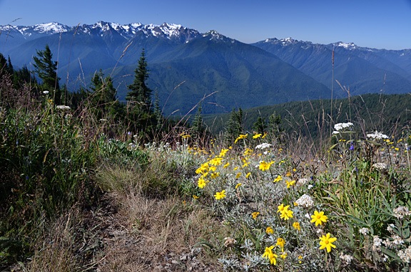
First, consider why charted wilderness areas exist. The government is protecting these areas, for whatever reason. Usually, it’s because they don’t want aircraft noise to interfere with wildlife — especially wildlife breeding and habitat maintenance. Sometimes its because they want “natural” areas to be kept quiet for visitors trying to enjoy the beauty of nature in peace.
How do you feel about preserving quiet in these areas? Is it important to you? If you were on the ground, how would you feel if a helicopter or plane buzzed by at 500 or 1,000 feet? Would it bother you? How do you think it affects the people on the ground? People camping, fishing, hiking, meditating?
As the person who contacted me pointed out, when he flew in the area, he didn’t see a person for miles. So who would he be bothering?
The one thing I can say with certainty is this: If pilots typically “busted a wilderness area” by flying low through it and enough people on the ground noticed and complained about it, it’s far more likely that the government will respond by establishing a real rule to prevent it. Yes, at one time people were allowed to fly low-level through the Grand Canyon and Yosemite valley. But when enough complaints came in, regulations were written to make such activity illegal.
Would you want to see that happen with all the wilderness areas on the charts?
I know I wouldn’t.
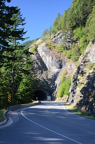 The road climbed south slowly into the mountains on a narrow strip of park land. We found a parking area right before one of two tunnels and Mike parked the truck. There was a view to the northeast and we could clearly see the Juan De Fuca Strait, which runs between Washington and Canada’s Vancouver Island. It was relatively hazy and the conditions weren’t good for photography.

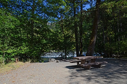 We were hungry and planned to dig into some of the cheese we’d brought along when we got to the observation point near the end of the road. But the road was closed for some kind of construction. So instead, we turned into the Altair Campground, which was mostly empty, and pulled into the first campsite, which was right along the river. We carried the cooler over to the picnic table, opened it up, and had a great meat, cheese, cracker, and cucumber lunch.
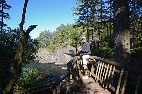 As we got closer and closer to the point, we could clearly hear the ocean waves crashing against rocks. There were a handful of short side trails to points where you could see the rocky shoreline. Some of them had been built up with rustic log rails to prevent a fall into the water below.
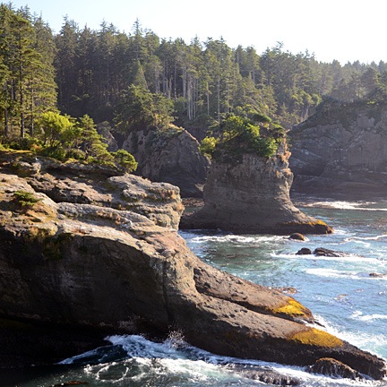 At the end of the trail was a platform that looked out to the northwest. There was an island out there with a lighthouse on it. To the north, was the opening of the strait and Vancouver Island; a container ship slowly made its way in toward the ports. Waves crashed on the shore against odd-looking formations called “stacks.”